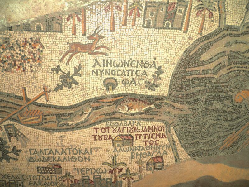
© 2009 Jan Herca (license Creative Commons Attribution-ShareAlike 4.0)
Bethabara is a town mentioned in John 1:28 as a place where John baptized. There is no clear unanimity among scholars as to where this town and also Ainon are located. According to the Madaba map, a mosaic from the 6th century, Bethabara was located next to the Jordan, near the mouth of the river in the Dead Sea, but on the eastern shore, while Ainon or Aenon would be located on the western shore. From the size of the letters on this map, it also seems that Ainon was the important town, while Bethabara was secondary. Scholars seem to debate whether or not the designations Bethany and Bethabara should be assumed to correspond to the same place and whether this place near the Dead Sea was the correct one. However, in my opinion the whole discussion is wrong from the start, since all the sources that speak of these places are very late, and the ancient writers who speak of them tend to change the name frequently. Thus, for example, apart from the fact that the place is sometimes mentioned as simply “Bethany”, other times as “Bethany Beyond the Jordan”, and other times as “Bethabara” (although the name Betabara only appears like this because of Origen, who apparently used it to avoid confusion with the other Bethany near Jerusalem), the names “Sapsaphas”, “Salumias”, “Salim”, “Salem”, “Ainon”, or “Aenon” are also used for this site, whether on one bank or the other. The designation as Salem seems to be due to a tradition that places the famous place where the king of Salem, Melchizedek, performed a sacrifice on a mound. The names of Salumias and Salim may also be derived from this. As for Ainon or Aenon, it is the Greek word for the Hebrew ay-yin, meaning fountain or spring. It is quite possible that there was a famous spring on the eastern bank which caused the name Bethany to be lost in favour of this other name.
In The Urantia Book it is referred to only as “Bethany beyond Jordan,” and never by any of the other designations. Furthermore, in The Urantia Book (UB 141:7.2) we are expressly told that Bethany was on the eastern bank, for it says that Jesus went to the hills “across the river, south of Jericho.” Therefore I believe that in Jesus’ time this place was always known by the name of Bethany, with “Beyond Jordan” added because it was across the river (the trans-Jordanian side), that is, on the eastern bank, and not where the Madaba map later placed it. Nearby, on either side, there must have been several places of worship, some of them by Jews, such as the place called Salem or Salim, where Melchizedek supposedly made a gesture in honour of Abraham, the father of the Jewish faith, or the place where the prophet Elijah also lived, near the Chorath torrent. As for the Christian faith, it was here that John the Baptist was believed to have begun to preach and baptise, and modern archaeology has unearthed the remains of a church and a monastery in the area, from the Byzantine period, which attest to the belief that this was a site revered by pilgrims from ancient times.

The town must have been important, as it was a necessary crossing point on the route to Jericho and Jerusalem along the eastern road that avoided Samaria. On the Madaba map we can see the drawing of large fish in the river, so there must have been some fishing industry; of date palms, for whose fruit, dates, the region was famous; a lion chasing an antelope, which attests to a fairly wild fauna; and a ferry or boat that crossed the Jordan River pulled by a strong rope from both ends of the river, although at a higher altitude to the north. I have doubts as to whether there was a passable ford in Jesus’ time at any time of the year, or whether this means of ferry was the only possible way of crossing the river.
¶ References
-
Biblical Archeology Society, MAdaba: The World’s Oldest Holy Land Map
-
Old Madaba map website. Additional information is found here and here.