© 2009 Jan Herca (license Creative Commons Attribution-ShareAlike 4.0)
Sometimes there are references in The Urantia Book that are striking for their accuracy and concreteness. They seem to have been placed there so that someone would take the trouble to verify them, or perhaps with some hidden intention that I cannot yet understand. But when I began to write the chapter on Jesus’ period of isolation after his baptism, the famous “forty days,” I could not escape the temptation to inquire into Jesus’ whereabouts during that period.
Throughout these eventful days Jesus lived in an ancient rock cavern, a shelter in the side of the hills near a village sometime called Beit Adis. He drank from the small spring which came from the side of the hill near this rock shelter. [UB 136:4.14]
This passage from The Urantia Book was so striking that it seemed to be crying out for investigation.
First, it was necessary to locate Pella and then see if there is currently a village that could answer to the name of Beit Adis.
Pella could not have been difficult to locate. As far as I knew, there were still some wonderful ruins of the city nearby, a town known today as Tabakat-Fahil. But my 1:200,000 scale maps were insufficient to locate either of them. I needed more precise maps, so I spent hours and hours scouring the Internet.
Suddenly, a small blessing. This link, which was available for a while, is now broken. But the same thing can be accessed with this new link
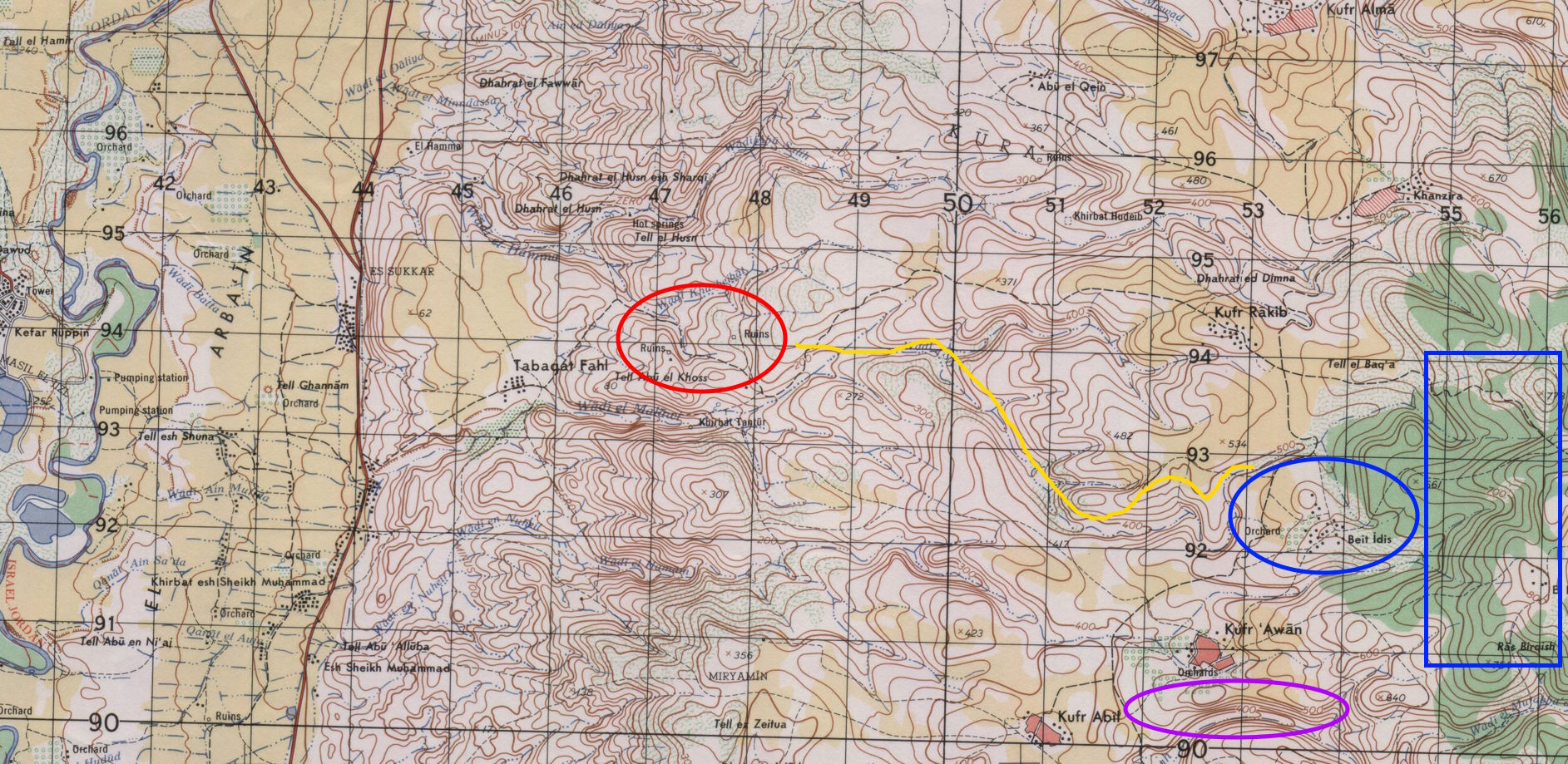
The website contains scanned maps at a scale of 1:50,000, the best I have found. And if you look at the map, it is not long before Tabaqat Fahl appears, very clearly. It is at the intersection of the line with coordinates 46 vertical and 94 horizontal.

You can see, nearby, that two positions with ruins (Ruins) are marked on the map. They are the remains of the ancient Pella.
And what about Beit Adis? Is there a town with a similar name today? There it is, clear and obvious on the map. It is called Beit Idis, and is located at the intersection of quadrants 54 vertical and 92 horizontal. From the map’s graphics, it appears to be nothing more than a small hamlet. There are orchards nearby, which confirms that the village has water for irrigation, undoubtedly coming from several nearby springs that flow from the east in a westerly direction.
If we look at the map we can easily see from the contour lines that from Pella to Beit Idis (Beit Adis) it is all uphill, going from less than 200 m in Pella to more than 500 m in Beit Idis. And the hills to the east of this village rise to 800 m.
Yes, but where is the cave where Jesus took refuge? There is no indication or symbol on the map to help us locate it. The most we can do is to roughly locate the location. The Urantia Book says that near the cave there was a spring where Jesus drank. Indeed, on the map we can see that there are several springs flowing down from the eastern slopes near Beit Idis. It could well have been near one of these springs that the sought-after cave was located.
That’s as close as you can get to locating the cave using maps. To find it, someone would have to travel to Jordan and start looking for it. Has anyone made this journey before?
Back on the Internet to search I find this gem: la cueva de la llave (previously the page was here)
For those of us who believe the revelations in The Urantia Book, this article by journalist and writer JJ Benítez is deeply moving. I don’t know if the Spanish author was the first person to discover the most likely location of the cave where Jesus took refuge. But he is certainly the first to divulge this information to the public, which is undoubtedly impressive. In the television series Planeta Encantado (Enchanted Planet), J.J. Benítez even shows the location in the filming of the episode entitled El mensaje enterrado (The buried message).
The location of the cave is, according to Benitez’s account, on the eastern slopes of Beit Idis, as we had guessed from reading the maps. From the description it is a natural grotto about 15 m long, 6 m wide and 3 m high. Next to it is a spring which has now been conveniently secured with a metal cover. Of course, all the indications fit with what is mentioned in The Urantia Book.
If the real cave has been discovered, we can say that this place represents one of the most memorable places in the life of Jesus. This natural cave may be, despite its lack of beauty and its dirtiness, the most sentimental and emotional place for all those who are followers of Jesus. There are many temples that commemorate the most representative events of the life of Jesus, but possibly none like this natural temple.
It is a blessing that the place has remained unknown and undiscovered by believers until today. Let us hope that future generations will leave the place as it is and that if the number of believers in the revelations of The Urantia Book grows, it will remain intact in its wild freedom, lost there in those hills, for those who wish to seek it to find it.
Regarding the discovery by J.J. Benítez of a hook for hanging beams, supposedly old, I have been able to slip a small hint into the story.
But all other considerations aside, I have one question about this whole cave business. Why did the authors of The Urantia Book give us this splendid clue to the location of the cave and not to other places? Did they perhaps wish to share with us a place of special spiritual significance?