© 2018 Halbert Katzen, JD
By Halbert Katzen J.D.[1]
A description of the location and physical characteristics of the Garden of Eden is provided in The Urantia Book. The location is said to have been on a long narrow peninsula that extended off the eastern coast of the Mediterranean Sea. According to The Urantia Book, Adam and Eve first lived at this location almost 38,000 years ago, and it further states that this peninsula sank into the Mediterranean Sea approximately 34,000 years ago. The topography of the seafloor in an area between Cyprus and the Syrian coast fits the description and looks to be the only area that could. Today, this area off the eastern coast of Mediterranean Sea drops down sharply, quickly reaching a depth of nearly one mile.
When The Urantia Book was published in 1955, sonar readings needed to create a detailed map of the eastern Mediterranean basin did not exist. Such maps were not created until decades after The Urantia Book’s publication. [2]
¶ Summary
According to The Urantia Book, “ADAM AND EVE arrived on Urantia [Earth], from the year A.D. 1934, 37,848 years ago.”[3] They lived on “a long narrow peninsula – almost an island – projecting westward from the eastern shores of the Mediterranean Sea.”[4] “[A]lmost four thousand years after Adam left the Garden . . . , in connection with the violent activity of the surrounding volcanoes and the submergence of the Sicilian land bridge to Africa, the eastern floor of the Mediterranean Sea sank, carrying down beneath the waters the whole of the Edenic peninsula.”[5] These few statements about the shape, location, and fate of the Garden of Eden are not all that The Urantia Book has to say on this subject. But they are sufficient for introducing this topic.
When it was published in 1955, sonar mapping had not yet provided sufficiently detailed images of the eastern Mediterranean seafloor to consider the merits of The Urantia Book’s assertions. Today, images of the Mediterranean seafloor, created with the use of advanced sonar technology that was developed more than thirty years after The Urantia Book was published, reveal correlations to all of The Urantia Book’s statements about the shape, location, and fate of the Garden of Eden.
¶ Complete report
The Urantia Book’s story about Adam and Eve and the Garden of Eden is considerably different than the one found in the Old Testament. Among other things, The Urantia Book says that Adam and Eve were genetically superior to the rest of humanity, and it provides an extensive review of the role that they and their progeny played in the development of human civilization.[6] Genetics research published in 2006, tracing a specific upgrade in the genetic history of human beings, lends powerful support to The Urantia Book’s account. See the Adam and Eve Report.
Along with advances in sonar technology and genetics research, Plate Tectonic Theory also supports The Urantia Book’s story about Adam and Eve and the Garden of Eden. This now widely accepted theory, which was not developed until about ten years after The Urantia Book was published, correlates with The Urantia Book’s description of the fate of the Garden of Eden. This report addresses the plate tectonic issue sufficiently to inform readers about how this is harmonious with assertions made about the Garden of Eden. See the Pangaea to Plate Tectonics Report for a fuller appreciation of the how The Urantia Book’s statements about geophysics predated the broad scholarly support that now exists regarding Pangaea (the theory that all the continents were once joined together), continental drift, sea floor spreading, and plate tectonics.
Before reviewing exactly how scientific advances are corroborating The Urantia Book’s statements about the Garden of Eden, the first step is to take a look at the history of mapping the bottom of the earth’s oceans. The 1961 Life Pictorial Atlas of the World states:
Man had long been able to map in fairly accurate detail the land areas of his globe before he was able to ascertain the configuration of the bottom of the tremendous oceans that occupied 139,434,000 square miles of the his world’s surfaces. It was not until 1957-1958- the International Geophysical Year-that scientists of many nations worked together as a tremendous team to compile a comprehensive portrait of the oceans’ floors. The maps here and on the following pages incorporate their findings.[7]
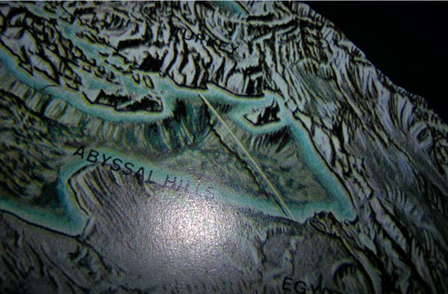
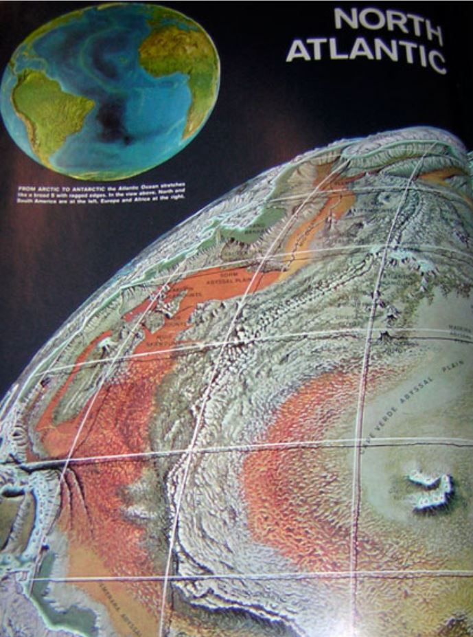
[Image 1] is a photograph taken from a page in this atlas showing the eastern side of the Mediterranean Sea. Under the yellow line is a shadow running across the Mediterranean Sea’s basin. As can been seen from [Image 2], that yellow line is part of a longitude and latitude grid placed on the globe that was created to depict the findings mentioned above. On the upper right side of the longitude line in [Image 1] is an island. This is the island of Cyprus.
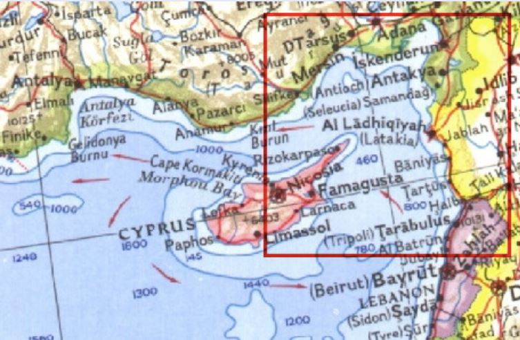
The commentary and pictures in the 1961 Life Pictorial Atlas of the World indicate that mapping the bottom of the oceans had not developed sufficiently when The Urantia Book was published to corroborate the statements it makes about the Garden of Eden. Similarly, a National Geographic map from 1962 of the eastern Mediterranean is not particularly detailed, providing only a few topographic lines and sporadic depth readings (see [Image 3]).
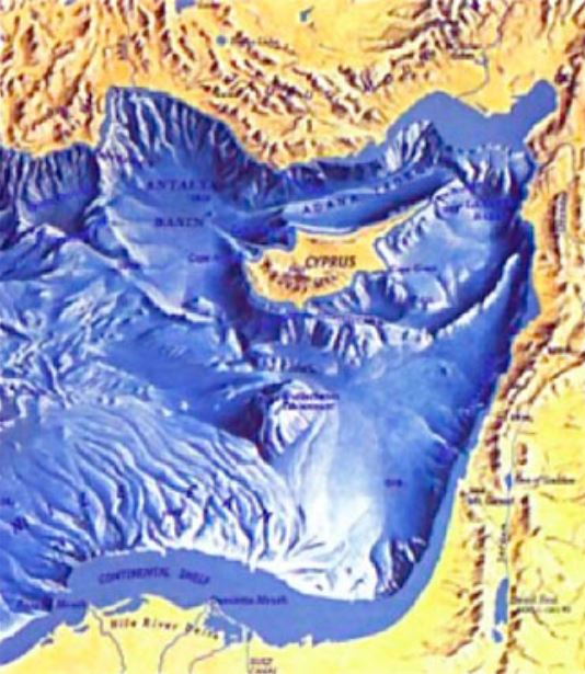
As [Image 4] reveals, by 1982 better maps became available, showing significantly more details of the seafloor. Note that in this image the shoreline drops down immediately and there is a mountain range right along the coast. The southern and central portion of the eastern Mediterranean basin is generally flat, while the area between the island of Cyprus and the coast has a topography that looks like it could match up with The Urantia Book’s description of a “long, narrow peninsula” projecting westward from the eastern shore. But still, these images are not nearly as revealing as the ones that were created from sonar readings gathered by the Russians in 1989, using even more advanced sonar technology.
It took sonar technology developed over thirty years after The Urantia Book was published to provide images with sufficient detail to consider the merits of its assertions. To appreciate the significance of these more detailed maps, one must first become familiar with the specific statements made in The Urantia Book about the size, shape, location, and topography of the Garden of Eden, as well as its description of how this peninsula sank to the bottom of the Mediterranean Sea.
The Urantia Book states:
The committee on location . . . reported favorably concerning three possible locations: The first was an island in the Persian Gulf; the second, the river location subsequently occupied as the second garden [between the Tigris and Euphrates rivers]; the third, a long narrow peninsula – almost an island – projecting westward from the eastern shores of the Mediterranean Sea.
. . .
This Mediterranean peninsula had a salubrious climate and an equable temperature; this stabilized weather was due to the encircling mountains and to the fact that this area was virtually an island in an inland sea. While it rained copiously on the surrounding highlands, it seldom rained in Eden proper. But each night, from the extensive network of artificial irrigation channels, a “mist would go up” to refresh the vegetation of the Garden.
The coast line of this land mass was considerably elevated, and the neck connecting with the mainland was only twenty-seven miles wide at the narrowest point. The great river that watered the Garden came down from the higher lands of the peninsula and flowed east through the peninsular neck to the mainland and thence across the lowlands of Mesopotamia to the sea beyond. It was fed by four tributaries which took origin in the coastal hills of the Edenic peninsula, and these are the “four heads” of the river which “went out of Eden,” and which later became confused with the branches of the rivers surrounding the second garden.[8]
The architectural plans for Eden provided homes and abundant land for one million human beings.[9]
[A]lmost four thousand years after Adam left the Garden . . . , in connection with the violent activity of the surrounding volcanoes and the submergence of the Sicilian land bridge to Africa, the eastern floor of the Mediterranean Sea sank, carrying down beneath the waters the whole of the Edenic peninsula. Concomitant with this vast submergence the coast line of the eastern Mediterranean was greatly elevated. And this was the end of the most beautiful natural creation that Urantia has ever harbored. The sinking was not sudden, several hundred years being required completely to submerge the entire peninsula.[5:1]
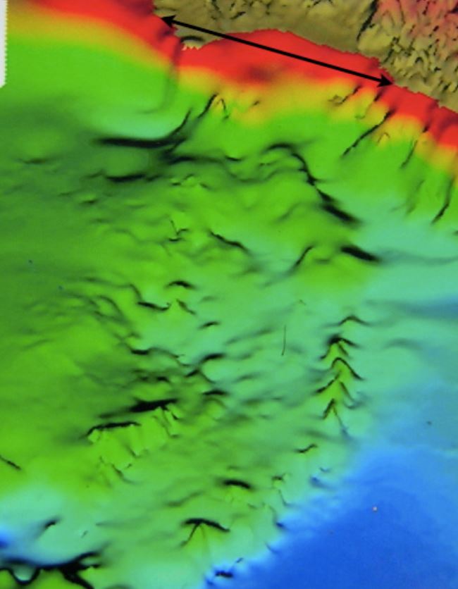
[Image 5] and [Image 6] are provided courtesy of Robert Sarmast.[10] They were created from the Russian sonar readings done in 1989. The red color indicates where the shoreline starts; the earth tones represent the land. The areas on the ocean bottom depicted in turquoise and blue indicate a depth of 4,000 to 5,000 feet. The black arrows in [Image 5] and [Image 6] show a distance of twenty-seven miles. These arrows are included because, according to The Urantia Book, “the neck connecting with the mainland was only twenty-seven miles wide at the narrowest point.” These arrows also help provide a perspective on the different scale that had to be used for the vertical dimension. By looking at the sudden vertical drop off the southeast coast of Cyprus, we can see that this vertical distance on the page, representing about one mile in depth, is about two thirds the length of the black arrow depicting a distance of twenty-seven miles. This difference in scale makes heights look more pronounced.
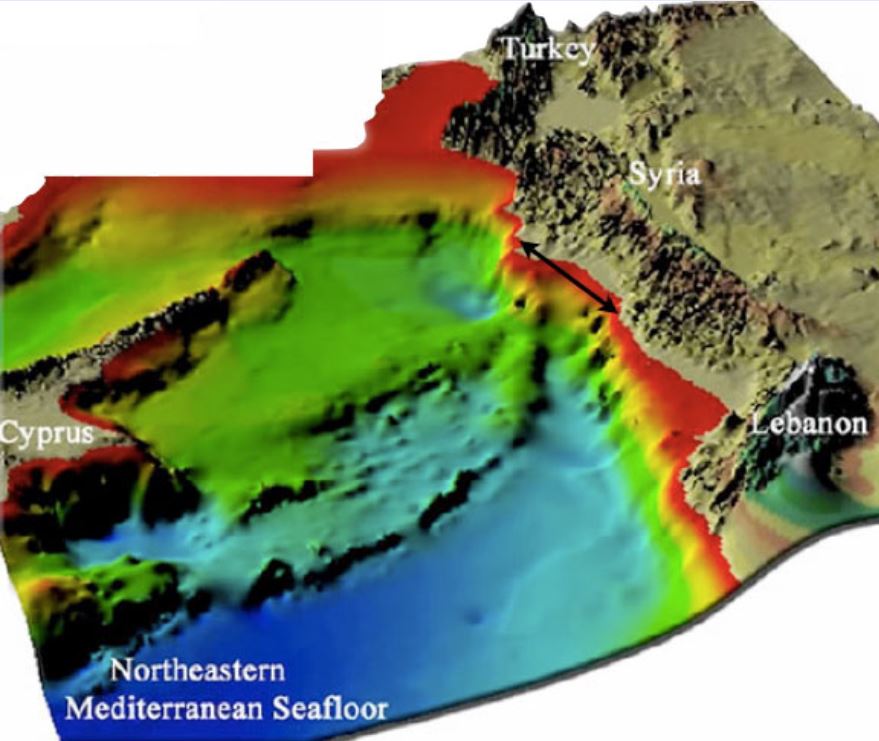
In [Image 5] and [Image 6] the topography between Cyprus and Syria reasonably fits the description in The Urantia Book of what a “long narrow peninsula” with “encircling mountains,” “projecting westward from the eastern shores of the Mediterranean Sea,” might look like if it sank about a mile beneath the Mediterranean Sea some 33,000 years ago. Adding additional support to the theory that this formation between Cyprus and Syria relates to The Urantia Book’s description of the Garden of Eden is the depiction in [Image 7] of the tectonic plates that join together in this region. Note how the line to the east of Cyprus marking the convergence of the Anatolia and the Sinai plates is precisely located in the area where the “long narrow peninsula” topography occurs.
Geophysically speaking, the eastern Mediterranean basin is an active area, both currently and historically. A 2006 article in Geophysics Journal International (GJI) explains some of the fundamental characteristics of this area, while also acknowledging that there is still more to learn.9 Research papers on tectonic plate activity are steeped in the terminology of that discipline. Given the numerous images included in the GJI article (which is not very long), it is reasonably understandable to someone who is not sophisticated in this field, assuming one is willing to look up the definitions of some of the key terms. Because the relevant information is sufficiently provided by [Image 7] and because the primary support for The Urantia Book’s statements about the Garden of Eden come from the sonar images, this report is not going to do an in-depth analysis the GJI article. Mention will be made only of those aspects that relate most directly to interpreting the sonar images.
This area marks the convergence of three tectonic plates. According to the GJI article, “[. . .] McClusky et al. (2000) present in their maps two arcs, one north and the other south of Cyprus, suggesting that Cyprus behaves as an independent block. . .”[11] This statement regarding the independent behavior of Cyprus, along with the fact that Cyprus and Garden of Eden area are separated by the line demarcating the Anatolia and Sinai plates, lends support to the theory that the topography between Cyprus and Syria might have sank into the Mediterranean irrespective of the historic geophysical activity of Cyprus.
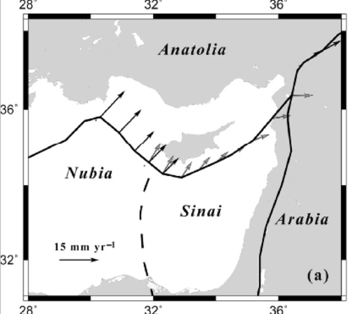
The GJI article also states that the “Cyprian Arc is subjected to subduction, collision and transcurrent tectonic processes.”[12] Unlike the western side of the arc, where the Nubia plate primarily is experiencing a process of subduction (pushing under the Anatolia plate), the eastern side of the arc is experiencing a confluence of various tectonic plate forces. In all likelihood, these forces to some degree would distort the topography of the peninsula as it sank into the Mediterranean Sea.
With these forces in mind, now consider in [Image 5] and [Image 6] the two elevated areas that converge at the shore near the black arrow and then run roughly parallel to each other as they project westward from the eastern shore of the Mediterranean. The convergence near the shore is consistent with The Urantia Book’s description of the neck narrowing to twenty-seven miles. Though the elevated areas converge to less than twenty-seven miles, the shoreline is noticeably more rugged than the smoother descending shoreline just to the south. Just to the north of the convergence there is a deeper drop compared with everything else to the north. Given the depth to the north, the more rugged terrain in the twenty-seven mile range near the shore, and the confluence of tectonic plate forces in this area, The Urantia Book’s description of the Eden and its fate appears generally consistent with topography revealed in [Image 5] and [Image 6].
Additionally, note how on the western side the elevated northern range breaks line and is further south as it approaches the southeastern tip of Cyprus. As well, for the most part this northern ridge is less sharply defined than the southern range of hills. Based on the position of the line separating the tectonic plates in [Image 8], it appears that the northern side of what would be the now submerged peninsula is situated more directly over the convergence of the plates. This can be appreciated by noticing that where the tectonic plate line breaks onto the shore is also the location of the more northern end of the double arrow seen in [Image 5] and [Image 6].
The Urantia Book’s description of what happened to the Garden of Eden is consistent with:
- the smoother topography associated with the northern line of hills,
- the way the western edge of this range appears displaced to the south, and
- the narrower-than-twenty-seven-miles convergence at shore with the depressions on either side associated with a more rugged descent off the shore in that area.
[Image 8] (also provided courtesy of Robert Sarmast) is helpful for considering the merits of what The Urantia Book says regarding the size of the peninsula. “The architectural plans for Eden provided homes and abundant land for one million human beings.” Curiously, the island of Cyprus offers a conveniently placed landmass for appreciating how much land is needed for one million people. According to the Encyclopedia Britannica, the population for the entire island of Cyprus in 2005 was 968,000 persons.[13]
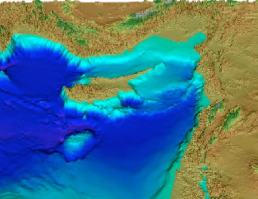
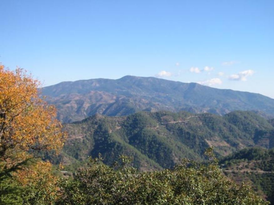
Directly south of the southeast corner of Cyprus the water becomes particularly deep. Using [Image 5] for reference and comparing the depression to the twenty-seven mile long double arrow, the depression looks to be about thirty miles east to west and twenty miles north to south. Assuming that the eastern side of this depression marks the western edge of what would have been the Garden of Eden, the length and width of Eden roughly corresponds to the size of Cyprus. Cyprus is a bit bigger, but it also has a range of mountains covering most of the inland area. Mount Olympus rises up to 6,404 feet.[14] In contrast, the topography between Cyprus and Syria that matches up with The Urantia Book’s description of Eden shows narrower ranges “encircling mountains” (like the one along the north coast of Cyprus), leaving the central plain of Eden more easily inhabitable than central region of Cyprus.
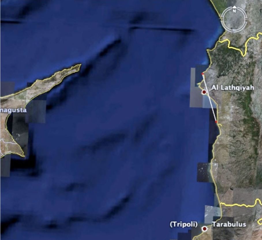
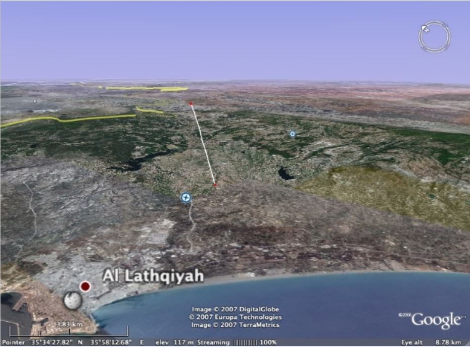
The last correlation to be made with The Urantia Book’s description of the Garden of Eden pertains to following two statements: “The great river that watered the Garden came down from the higher lands of the peninsula and flowed east through the peninsular neck to the mainland and thence across the lowlands of Mesopotamia to the sea beyond.” “Concomitant with this vast submergence the coast line of the eastern Mediterranean was greatly elevated.” In Image 10] and [Image 11] a depression in the mountains can be seen that runs parallel the angle at which the now-submerged peninsula protrudes from the shore, and it is also aligned with where the converging ridges meet the shore.
In Image 10] the line at the shore represents the twenty-seven mile distance marked by the double arrows in [Image 5] and [Image 6]. The line that is superimposed onto [Image 11] marks the depression in the mountains that can also be seen in Image 10] directly above where the name of the coastal city, Al Lathqiyah, appears. Note also from Image 7 that this dip in the mountains is right where the Anatolia and Sinai plates meet.
The eastern side of the Mediterranean was and continues to be a geophysically active. It is easy to speculate about how this area may have been affected 33,000 years ago by tectonic plate shifts, earthquake and volcanic activity, and flooding occasioned by a submergence of a land bridge from Sicily to Africa. However, these various influences make it a challenging area for geophysicists to make definitive statements about the history of this area. In time, as geophysicists continue to develop their understanding of this area, even more corroborations may develop concerning The Urantia Book’s account of the Garden of Eden.
For now, at least advances in sonar technology allow us to see a topography between Cyprus and Syria that is harmonious with all of The Urantia Book’s statements about the size, shape, and location of the Garden of Eden. Even the description of how water flowed off the peninsula can be correlated with the topography in this region. As well, tectonic plate theory, which was not developed until more than a decade after it was published, also lends support to The Urantia Book’s depiction of the fate of Eden.
¶ Links
¶ External links
- This report in UBTheNews website
- Other reports in UBTheNews webpage
- Topical Studies in UBTheNews webpage
- Life Pictorial Atlas of the World, Life magazine Randy McNally, 1961.
- Robert Sarmast,Discovery of Atlantis, First Source Publications, 2006.
- Shimon Wdowinski, Zvi Ben-Avraham, Ronald Arvidsson, Goran Ekström, Seismotectonics of the Cyprian Arc, January 2006, Geophysical Journal International, https://academic.oup.com/gji/article/164/1/176/2071574
- Mart, Y.; Ryan, W., The tectonics of Cyprus Arc: a model of complex continental collision, https://ui.adsabs.harvard.edu/abs/2003EAEJA.....2282M/abstract
- Ergün, M.; Okay, S.; Sari, C.; Oral, E. Z., Gravity and magnetic anomalies of the Cyprus arc and tectonic implications, https://ui.adsabs.harvard.edu/abs/2003EAEJA.....1663E/abstract
¶ References
With special thanks to Robert Sarmast. ↩︎
Research from the last several years, tracing a specific upgrade in the genetic history of human beings, also lends powerful support to The Urantia Book’s recounting of the story of Adam and Eve. See Adam and Eve. ↩︎
Life Pictorial Atlas of the World, Life magazine and Randy McNally, 1961. ↩︎
Robert Sarmast’s research, published in Discovery of Atlantis, led him to conclude that there is link between the mythology of Atlantis and the religious accounts related to Adam and Eve. He believes that the story of Atlantis developed because a new tribe of people came to occupy the architecturally developed Edenic peninsula after Adam, Eve, and their progeny abandoned this area. By the time the peninsula sank, some 4,000 years after Adam and Eve left, it had become disassociated with the civilization they had started. According to Sarmast’s research, the connection between Garden of Eden and Atlantis is that they had the same geographic location, but became associated with two different cultures. Sarmast attempted to find vestiges of human civilization at this location between Cyprus and Syria. More can be learned about his work by going to http://discoveryofatlantis.com/. Much thanks goes to him for allowing the UBtheNEWS project to use the images that were created in connection with his work. ↩︎
Shimon Wdowinski, Zvi Ben-Avraham, Ronald Arvidsson, Goran Ekström, Seismotectonics of the Cyprian Arc, January 2006, Geophysical Journal International, https://academic.oup.com/gji/article/164/1/176/2071574, [Article GJI], p. 179. ↩︎
[Article GJI] p. 176. ↩︎