© 2006 Jan Herca (license Creative Commons Attribution-ShareAlike 4.0)
Machaerus is the name of a fortress inhabited by Herod Antipas where John the Baptist was imprisoned and where he was beheaded.
Near the site of the present ruins is a village called Mukawer, the name given by the Arabs to the existing Roman-Byzantine remains. Next to this village, on top of an isolated and barren hill, stand the ruins of what must have been the fortress. The Arabs gave the site the name Qalaat al-Mishnaqa.
This fortress was one of the most strategic defensive enclaves of the Jewish state in the Perea region on the border with the Nabataean kingdom. The site was erected by the Hasmonean Alexander Jannaeus in 90 BC (BJ VII 6:2). In 57 BC it was destroyed for the first time by the governor of Syria, Gabinius, who was sent by Pompey to suppress a revolt by the Hasmonean Aristobulus II. The structure was razed to the ground.

The palace was rebuilt by Herod the Great beginning in 30 BC (BJ VII 6:2-3). After Herod’s death, his son Antipas inherited it as part of the region of Perea. It was at the fortress that John the Baptist was imprisoned and killed (AJ XVIII 5:1-2,18:109-119; Mt 14:1-12; Mk 6:14-29; Lk 9:7-9; UB 135:12.1). After the death of King Agrippa I (44 AD), the fortress fell under the direct administration of the Roman prefecture.
When the Jewish Revolt broke out (66 AD) the Romans abandoned the fort to the rebels (BJ II 18:6), who remained there until 72 AD, when Machaerus was destroyed by the Romans after a long siege. The first part of the siege was led by General Cereale, and then the command passed to Lucilius Bassus. When the legions finished the wall (vallus) and the attack ramp (agger), some Zealots betrayed their comrades and handed the fortress over to the Romans (BJ VII 6).
Later Byzantine bibliographic sources only mention a small village called Maccaberi (Georgii Cyprii Descriptio, n. 1082; Cyrilli Vita Sabae, 82).
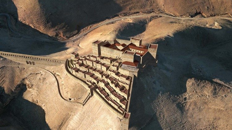
The isolated hill on which the fortress stands is situated 700 m above sea level and is located at the end of a spur between the Wadi Zerqa Ma’in to the north and the Wadi Heidan-Mujib (the Arnon River) to the south. The mountain, isolated by deep gullies, forms two hills to the southeast and northwest. It can be accessed from the Dead Sea in the west or from the Madaba region in the east.
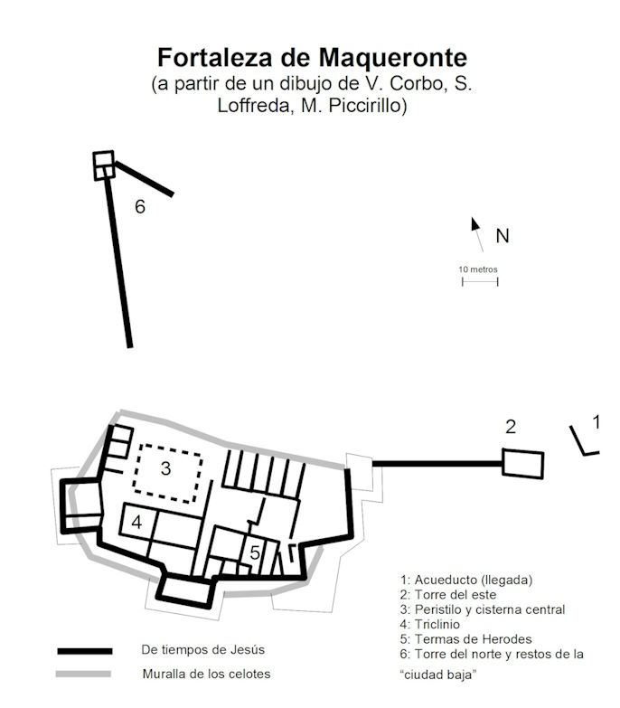
Archaeological excavations in the area have clarified Josephus’ distinction between the upper city and the lower city, the latter located on the northern slopes. The upper city housed the royal palace, defended by four towers, of which only three have been identified. The remains of the palace are so destroyed that it is difficult to distinguish which corresponds to which period. The upper main structure (possibly from the time of Herod the Great) was divided into two main wings with a paved corridor running north to south. The east wing ran along the sides of a paved courtyard covering a cistern with baths to the south and elongated rooms on the north side. The west wing had a peristyle to the north, built over a cistern, and connected to a triclinium to the south. Stucco, fragments of columns, and Ionic and Doric capitals and bases have been found at the bottom of the cistern.
In its final period, a polygonal defensive wall was built around the entire perimeter of the upper city to protect the rebels from the Jewish revolt. Remains of the Zealot presence have been found at the site, such as two ovens in the mosaic floor of the apoditerium and a poorly worked wall on the west side of the triclinium.
In the lower city, only a few houses have been excavated within the northern wall. The wall was defended on both sides by a tower. Inside the northwest tower, the protected opening of a large cistern could be accessed.
The upper and lower towns were accessible from the east via a 15 m high bridge that connected the fortress to the plain. It also served as an aqueduct conveying rainwater to the cisterns dug into the northern slope of the mountain. A lower aqueduct also served the same purpose for the cisterns located at a lower elevation.

¶ References
-
Report of the excavations of the 2016-2017 campaign (in English)
-
Flavius Josephus, Complete Works, Jewish Antiquities (AJ) and Jewish Wars (BJ), Editorial Acervo Cultural, 1961.