[ p. 135 ]
One of the greatest truths of Geology is that the continents are continually undergoing change; they are from time to time dightly and irregularly elevated or depressed over more or less extensive areas, while long and narrow tracts toward their marg ing slowly subside tens of thousands of feet. Later the subsiding tracts rise fairly rapidly into mountains, and these are subsequently vertically reelevated time and again. Outside of the long and comparatively narrow tracts are rising wide borderlands that furnish the sediments for the shallow seas of the sinking tracts, and that once extended hundreds of miles into the oceans beyond the present shorelines. These crustal movements, along with erosion, were the primary causes for the changing topographic and geographic aspects of North America, which will now be taken up in greater detafl.
The unravelling of North American geology and stratigraphy began in earnest with the state survey of Massachusetts in 1830, and that of New York in 1836. During this decade there were organized no fewer fifteen state surveys and two national ones. In the next twenty years, eleven other surveys came into being, besides the path-finding federal railway surveys across the Rocky Mountains made by Emory, Marcy, Pope, Ives, and Newberry.
The question of mountain origin could not fail to attract the attention of these early pioneers in American geology, and here the path was blazed first by the Rogers brothers and later by James Hall followed by James D. Dana and Joseph LeConte, the area of their generalizations being chiefly the Appalachian Mountains. As early as 1842, the Rogerses offered an explanation, not only for the structure of the Appalachians but for their causes as well, though their ideas were not published in detail imtil 1857, when they were embodied in the epochal Final Reports on Pennsylvania.
¶ Geosyndines
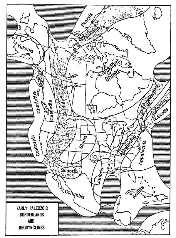
(Study Figs., pp. 139 and 169)
As a result of the work in the Appalachians of Pennsylvania and Virginia, in the valley of the St. Lawrence, and in New York, [ p. 136 ] James Hall came to see that mountains occur only in areas of greatest sedimentary accumulation, and never where formations are thin. For example, the Paleozoic formations in the Appalachian region are possibly ten times and certainly six times thicker than the equivalent deposits of the same seas in the Mississippi Valley. These thick sediments we now know were accumulated in narrow troughs or synclines that persisted as shallow seaways for long periods of geologic time. Such troughs were unstable areas of the earth’s crust, sometimes subsiding and sometimes rising until their great thicknesses of sediments were folded into mountains. In other words, as Hall saw, mountains arise out of the very areas that previously had long been seaways or synclines of subsidence and sedimentation. His term “ synclines ” for these long narrow areas was altered by Dana to geosynclines, since they do not have the simple syncline structure, but are made up rather of many true or simple synclinals as weE as anticlmals. The mountain system that eventually rises out of a geosyncliue, Dana at the same tune called a syndinorium. Synclinorial mountains arise subsequently out of the strata of a geosyncline, through folding due to lateral compression, following upon a shrinking earth. See also Pt. I, pp. 304-306, 380, 385, and 396.
Since the time of Hall and Dana, North American stratigraphy has made much progress, and we now know that early in Proterozoic time there were in existence three geosynclines: (1) the Appalachic, in the eastern part, trending northeast-southwest; (2) the Cordilleric, in the west, with a north-south axis; and (3) the Ontaric, in the medial part of the continent, striking nearly east and west. The last-named was folded into moimtains at the close of the Proterozoic. These troughs need not here be described further, since this will be done later on. The student should from time to time consult the %ures on pages 139 and 159, so as to impress upon his mind the geographic position of the geosynclines and lands.
In the Paleozoic era there were four geosynclines: (1) Appalachic, and (2) Cordilleric, as before; (3) Acadic, in sympathetic relation with Appalachic; and (4) Franklinic in the American Arctic regions, with a northeast-southwest trend. The northern half of the Appalachic geosyncline (= St. Lawrencic trough), and allof the Acadic geosyncline were converted into mountains toward the close of the Devonian, while the Franklinic and the southern half of the Appalachic rose into mountains toward the close of the Paleozoic. Therefore of the Paleozoic geosynclines only the Cordilleric continued into the Mesozoic.
[ p. 137 ]

Fig. 1. — James HaJl (1811-1898). Father of the theoiy of geosynclines. Fig. 2. — James D. Dana (1813-1895). Professor of Geology at Yale. The first to put into working order the theoiy of mountain building out of geosynclines.
Fig. 3. — Henry D. Rogers (1808-1866). State Geologist of New Jersey and Pennsylvania. One of the first to unravel the Appalachian structure. Fig. 4. — Joseph LeConte (1823-1901). Professor of Natural History at the University of California. Exuounder of Dana’s theoiy. A great lover of the Sierra Nevadas.
[ p. 138 ]
In Mesozoic time there developed out of the great Cordilleric geosyncline a long and narrow land, the Central Cordilleran geanticline (see p. 141). Then during the Cretaceous there lay (1) to the east of this land the recently developed vast Rocky Mountain geosyndine, and (2) to the west of it the smaller Pacific geosyncline. Finally, at the close of the Mesozoic the former trough was folded into the Rocky Mountains, while a southern part of the Pacific geosyncHne continued as such into Cenozoic time.
Embayments. — The geosynclines also often had great connecting bays called embayments, which usually endured during the existence of the geosyncHnes. Prominent among them were (1) the Ouackitic embayment, trending east-west across Arkansas and Oklahoma; (2) the Sonoric embayment, also extending east-west through northwestern Mexico into Texas; and (3) the Alexandric embayment of southeastern Alaska. Finally (4) the Northumberlandic embayment was a post-Devonian seaway between the mountains of Acadis. All of these embayments were of Paleozoic time, though the Alexandrie one continued throughout the Mesozoic.
¶ Borderlands
(Study Fig., p. 139)
Borderlands are situated outside or oceanward of the geosynclines, and are periodically raised mto highlands, though they never appear to have been folded while the troughs on their inner sides were subsiding. They may have been faulted and tangentially sliced and thrusted toward the geosyncHnes while the troughs were subsiding, but this action appears to have taken place mostly during the times when the geosynclines were being folded into mountains. Because the borderlands are periodically raised, they are the regions from which most of the elastics have been derived and dellvered into the geosynclines.
The borderlands formerly extended an unknown distance out into the oceans. From the quantity of sediments that they have furnished to the geosynclines, it is certain that they continued beyond the present strandlines at least 200 to 300 nules, and some of them doubtless considerably farther. Their geologic histories are as yet but Httle known, but the quantity and nature of the elastics derived from them indicate their extent, the times of their periodic elevation, and that they were composed essentially of cr3rstalline rocks, and mainly of granites.
North America is margined on the east by the borderlands Acadis, Apalachis, and Antillis, each one of which has its own geologic [ p. 139 ] [ p. 140 ] structure and history, though almost nothing is known of the history of Antillis. Along the west coast is the greatest of all borderlands, Cascadis, which later on divides into Californis and Charlottis. Mexico, or Columbis, appears to be an old nucleus, while its northeastern extension Llanoris is the borderland of the Ouachitic embayment. Finally, Arctic America is bordered by Pearyis, part of which is now elevated, along with the Franklinic geosyncline, into the folded United States Mountains.
¶ Geantidines
(Study Fig., p. 141)
The term geanticline was proposed by Dana in 1873 for “the upward bendings in the oscillations of the earth’s crust — the geanticlinal waves or anticlinoria.” His tjrpical example was the Cincinnati arch, though later on he also included (imder the term anticlinoria) far greater and even continental (epeirogenic) arching. Beginning with simple, depressed, and restricted arches, the term therefore came to be applied to all archings of lesser or greater extent.
Greanticlines and geosynclines are complementary flexures of the lithosphere, and the regularly folded, faulted, and thrusted outer part of the lithosphere, where these structures can be easily made, is known as the tectonosphere. In the area of the oldest mountains, where all of the tectonosphere has been worn away, as in the Lake Superior-Ontario-Quebec regions, one gets to see the originally deeper zone of rock flowage and granite bathylithic intrusions. These structures of the deeper lithosphere are very difiB,cult to interpret correctly.
Of geanticlines, the best known ones are the following: The Cincinnati geanticline was defined by Dana in 1890 as the wide flexure in the lithosphere centering near Cincinnati, Ohio, and Nashville, Tennessee. Its width is something like 250 miles. It has in a general way the strike of the Appalachian folds, and was at times completely overlapped by the interior epeiric seas. The uplift began in middle Champlainian time, was followed by repeated reelevation, and during the middle and late Paleozoic the region continued as a low ridge or as islands in the eastern inland seas.
The New Brunswick geosyncline was in existence very early in the Paleozoic and continued up to the close of the Devonian as the highland between the Acadic and St. Lawrencic geosynclines. It includes the granitic area of eastern Connecticut and Rhode Island and the White Mountains of New Hampshire, and strikes [ p. 142 ] across central Maine into northern New Brunswick and southern Newfoundland. Its present width averages more thau 100 miles.
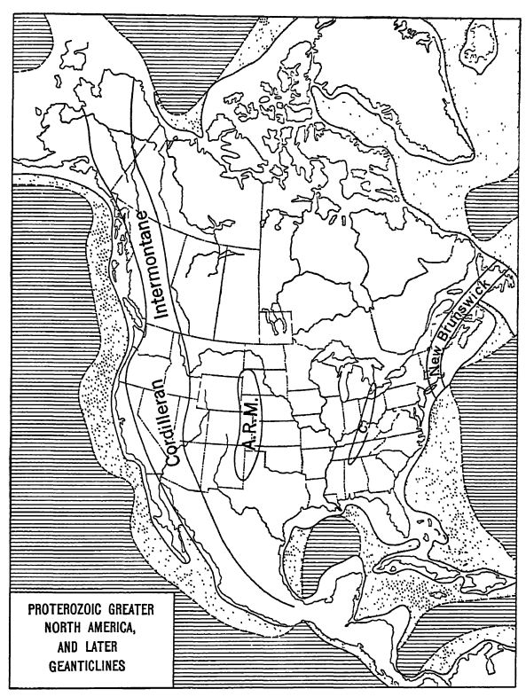
The Ancestral Rodcy Mountains geosyncline described by Lee arose late in the Paleozoic across eastern Colorado and New Mexico,’ western Kansas and Oklahoma, and northwestern Texas. To the west of it lay the Cordilleric seas of late Pennsylvanian and Permian times, while to the east of it were the brackish-water Mississippian seas of the same periods. These mountains were base-leveled in early Jurassic time, since late in this period and during the Cretaceous the Rocky Mountain sea completely transgressed the roots of this geanticline. A part of it is the present reelevated Front Range (Long’s and Pike’s peaks) of Colorado.
Most extensive of all the geanticlines was the Central Cordilleran (in Fig. 40 called Cordilleran Intermontane), extending from Alaska into Central America. To the east of it was the vast Rocky Mountain geosyncline, and to the west the smaller Pacific inland seas. This, the greatest geanticline of North America, began to appear in Nevada, Utah, and Idaho certainly as early as the late Triassic, and at the close of the Jurassic was completed into Alaska. This old arched land exists to-day as the elevated plateaus known as the Northern Interior, Columbia, and NevadaSonoran.
¶ Collateral Reading
C. Schuchert, Sites and Nature of the North American Geosynclines. Bulletin of the Geological Society of America, Vol. 34, 1923, pp. 151-'230.