Public domain
[p. 448]
¶ Formations and Physical History
The time between the Archeozoic era and the deposition of the oldest system of rocks containing abundant fossils (the Cambrian) constitutes the Proterozoic era. It was the era when sedimentation first became the leading process in the formation of the geological record. During the era several great systems of sedimentary formations, unconformable with one another, were formed. With these sedimentary formations there is much igneous rock, some of which was intruded as sills and bosses, and some of which was extruded.
The Proterozoic rocks include the first great series of sedimentary strata which imply mature weathering, and the prolonged and continuous deposition, on low lands or in the sea, of weathered material derived from the adjacent lands. It is important to emphasize the inauguration of the dominance of these processes, for they have been the most conspicuous ones ever since. Taken as a whole, the era was marked by more igneous activity than any later one, and may therefore be regarded as a transition-time from the profoundly igneous era that preceded, to the markedly sedimentary eras that followed.
Stratigraphic relations of the Proterozoic rocks. Great unconformities separate the Proterozoic formations from the Archean below and from the Paleozoic above. Great unconformities usually involve three elements: First, a change in the attitude of the lower formation, as the result of which it is subject to erosion; second, a long period of erosion during which Its surface is much [p. 449] degraded; and third, another change resulting in the deposition of the upper series on the eroded surface (Figs. 305 to 307).
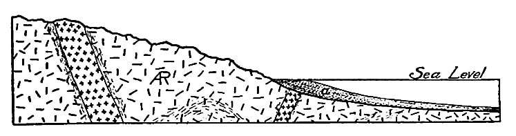
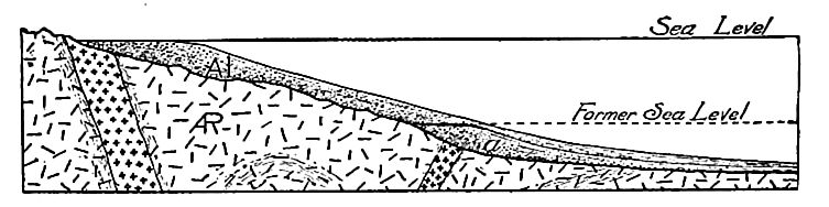
A sequence of events which might have given rise to the unconformable relations of the Archean and the Proterozoic, where seen, is illustrated by Figs. 342 and 343.Fig. 342 represents an area of land composed of Archean rock in such a position as to suffer erosion. The sediments derived from it are washed down to the sea and deposited in its waters (a). In Fig. 343, the land of the preceding figure is represented as having sunk so as to be partially submerged. A part of the sediments washed down from the remaining land are being deposited unconformably on the surface which has suffered erosion. The sediments a are older than the sediments Al, though the latter may be the oldest now accessible.
Great lapses of time were doubtless involved in the development of the unconformity between the Archean and the Proterozoic formations, but of this interval there is little more than conjectural knowledge.
[p. 450]
Though unconformity between the Archean and the Proterozoic is wide-spread, it is presumably not universal. There were probably places, even on the land-areas, where the surface of the Archean did not suffer notable erosion before the deposition of Proterozoic sediments upon it, and there were quite certainly such places in the areas continuously covered by the sea.
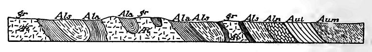
Subdivisions. No classification of the Proterozoic formations has general application, but in the Lake Superior region, where these rocks are best known, four great unconformable systems are referred to this era. In some other regions the number is three
(Fig. 344), in others two and in still others but one. In most places each system is thousands of feet in thickness, but, in spite of this, they do not constitute a complete record of the era. The unconformities between them show that, after the formation of each, there was a disturbance of relations between the sources of the sediments (the lands) and the sites of their deposition (chiefly the sea). Each unconformity appears to mark a prolonged period of erosion in the region where the formations are exposed, and deposition somewhere else. The only record of these periods is the unconformities themselves.
Proterozoic sedimentation. The surface of the Archean on which the Proterozoic sediments were deposited was probably comparable to existing land surfaces of crystalline rock which have been long exposed to weathering and other phases of erosion. The [p. 451] topography was doubtless more or less uneven, and the surface mantled by soil and residual earths (mantle rock) which had arisen from the decay of the underlying rock. Large and small masses of rock, more resistant than their surroundings, probably remained undecayed, or but partially decayed, in the earths which represented the products of more complete decomposition.
The general nature of the clastic sediments laid down on such a surface when it became an area of deposition may be readily inferred. They were made up chiefly of (1) the disintegrated products already on the surface, (2) the materials worn from the rocks by the waves, if the surface was covered by the sea, and (3) river detritus.
(1) One of the first effects of the Proterozoic seas, as they slowly transgressed the land — for it is presumed that this transgression was slow — was to work over, assort, and re-deposit the loose material found on the surface. The larger masses of rock suffered little transportation and wear, the sand and small bits of rock were rolled along the bottom and deposited in relatively shallow water, while the fine materials were carried out from the shore and deposited in the more quiet waters beyond. Deposits of gravel, sand, and mud were doubtless being made at the same time at different distances from the shore, and from the gravel on the one hand, to the finest mud on the other, there were all possible gradations. Changes in the position of the shore line, and changes in the depth of water incident to the sinking, of the land or the sea bottom, brought about the deposition of fine sediment on coarse, and of coarse sediment on fine. Thus the sedimentary deposits came to be arranged in beds of different sorts, coarser and finer alternating in vertical section, and grading into each other laterally.
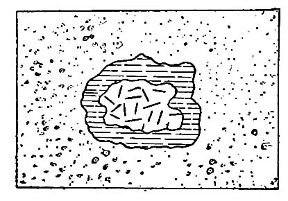
As the land of Archean rock was submerged by the Proterozoic seas, the coarse materials of the mantle rock were left upon the surface in many places, with little movement and little wear. At the base of the Proterozoic there is therefore often a wide-spread deposit of coarse material (gravel, etc.) derived from the underlying rock (Fig. 345). Such a formation is known as a basal conglomerate, and is often one of the best indices of an unconformity.
If the climatic conditions were like those of the present, the [p. 452] residual materials which the advancing Proterozoic seas found upon the surface which they transgressed had arisen chiefly by rock decay, and the material arising from the decomposition of the Archean was unlike the formation from which it came.
(2) Besides working over the decayed rock, the waves doubtless attacked the solid rock wherever exposures were favorable, just as waves here and there cut into, solid rock at the present time. The materials thus derived resembled the .parent formation in average composition, and are thus distinguished from those of the preceding class. The sediments of this second class were more or less intimately mingled with those which had been prepared in advance by the decomposition of the rock.
(3) The streams descending from the land must have brought down gravel, sand, and mud. The larger part of the river-borne detritus was probably made up of the decomposed products of rock, though a smaller part was doubtless derived by the mechanical action of running water on undecayed rock. Once in the sea, the river detritus was mingled with the sediments acquired in other ways.
Since some of the more soluble- constituents of the Archean rock extracted during the processes of decomposition probably remained in solution in the sea-water, it is to be presumed that the clastic sediments were, on the whole, more silicious than the rock from which they were derived.
The sorting power of moving water takes account of the physical conditions and properties of the material handled, and not of [p. 453] their chemical constitution; but in the decomposition of Archean rock, the quartz remaining in the residual mantle -was generally in larger particles than the aluminous products of the decomposition of the silicates, and under the sorting influence of the waves the quartz grains (sand) were more or less completely separated from the aluminous particles (mud). Thus materials which were unlike chemically were separated from one another because they were unlike physically. If the Proterozoic seas had abundant life which secreted calcium carbonate, or if their waters anywhere became overcharged with lime carbonate, limestone might have been formed.
Extent. While the sediments accumulated in the Proterozoic era are known in limited areas only, it is to be borne in mind that Proterozoic sediments were in reality more wide-spread than the seas of the time; for though coarse material from the land is not usually washed out far from the shore, material fine enough to be carried in suspension may be transported great distances, and small amounts of dust are constantly being blown from the land to all parts of the sea. In later 'geologic time, the life of the sea has occasioned considerable deposits even far from the land, and presumably over the whole of the ocean bottom. The same may have been true from the beginning of the Proterozoic era, for the beginnings of life go even farther back. From extra-terrestrial sources, and by precipitation from solution, further additions may have been made to the sediments accumulating on the sea bottom. Sedimentation, even if slow, was therefore doubtless in progress everywhere in the Preterozoic seas, and on some parts of the land as well.
The exposed formations. The sedimentary beds of the Proterozoic consist of conglomerates, sandstones, shales, and limestones, or of their metamorphic equivalents. Before being cemented or otherwise solidified into firm rock, their materials were gravel, sand, mud, etc. The manner in which such materials are derived from older formations and transported to places of deposition, has been explained.
Basal conglomerate is of rather common occurrence at the base of the several systems of the Proterozoic, while the overlying beds [p. 454] are of finer sediments. It is thought that the gravel of the conglomerates was accumulated along ancient shores, and that as the shores advanced upon the land, finer off-shore sediments were deposited on the shore gravels. Conglomerate beds which are not basal also occur, and point to changes in the conditions of sedimentation even where unconformities were not developed.
The Proterozoic systems contain thick and extensive beds of quartzite, composed chiefly of grains of quartz, firmly cemented.
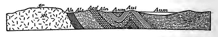
The quartz grains probably came from granitic rocks, and their separation from the other materials of the rock indicates the thorough decomposition of the rock, and ample opportunity for the rolling and rounding of the grains before they came to rest. As the quartzites of the Proterozoic are ^thousands of feet thick in some places, great bodies of rock must have been decomposed to furnish so much sand. There are also great beds of shales, or their metamorphic equivalents, which are interpreted as the clayey products of the decomposition which set the quartz free. Limestone also is present, from which it is inferred that the sea of the time had become calcareous by processes similar to those now in operation (p. 290), and that a portion of the calcareous content of the waters was extracted and deposited. Figs. 346 and 347 show sections of the Proterozoic rocks in the Lake Superior region.
[p. 455]
The inference that these ancient sediments were deposited in the same manner as the sediments of modern times is supported by the ripple- and other shallow-water marks on the sandstones and shales, and by their lamination and stratification, all of which are similar to those of sediments now being deposited.
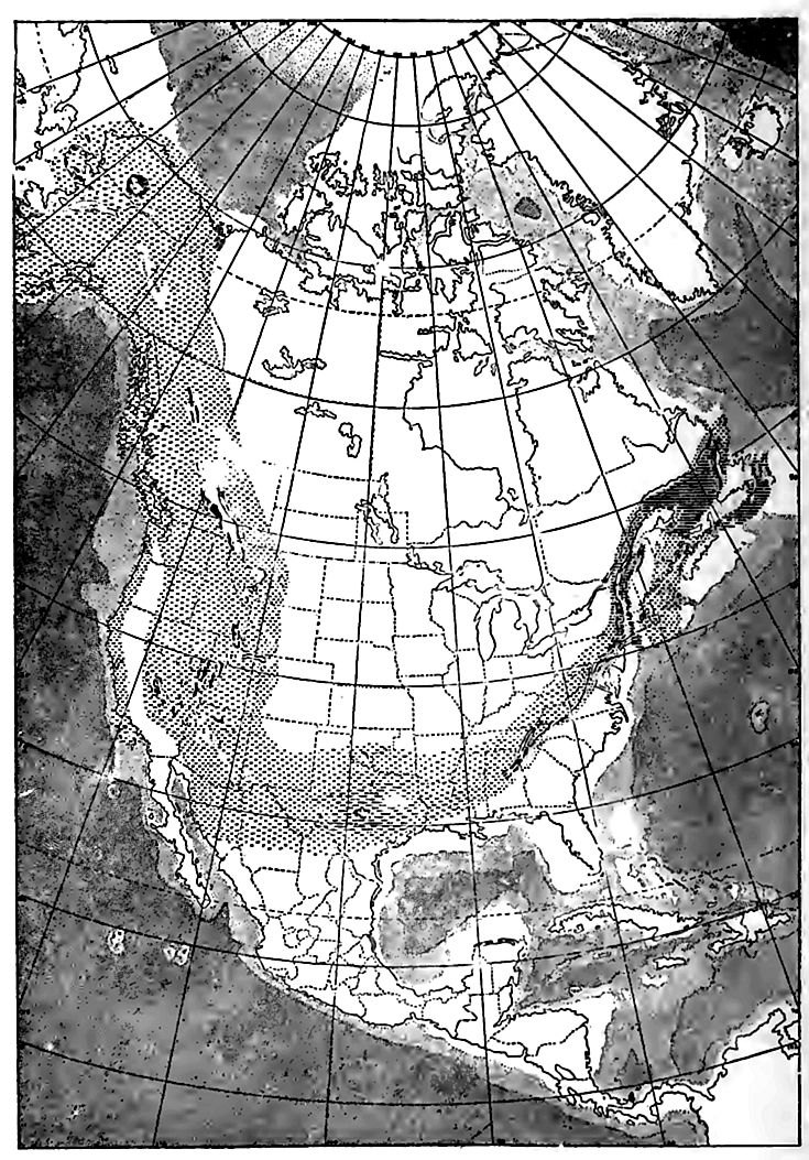
Geographic relations of the exposed Proterozoic to the Archean. Proterozoic rocks appear at the surface in many parts of North America, but in few regions have they been clearly separated from the Archean, and in very few have their subdivisions been worked out.Fig. 341 shows the area where rocks of known Proterozoic age lie at the surface, together with areas where they have not been differentiated from the Archean. In many places, the Proterozoic rocks at the surface are near areas of exposed Archean.
[p. 456]
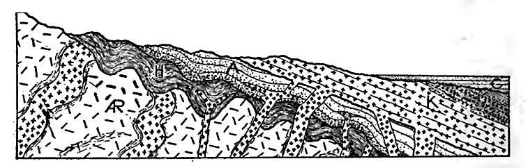
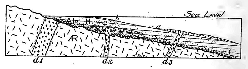
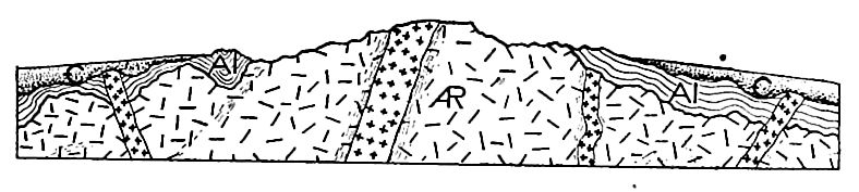
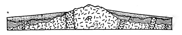
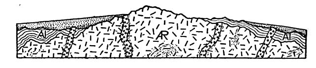
That the Proterozoic formations should be exposed most commonly about the borders of the Archean is made clear by Fig. 348, which shows, in section, the general relations of the Proterozoic systems (Al) to the Archean (^R) below, and to younger formations (tf?) above. The same relations are shown in ground-plan in Fig. 349. While the relations shown in these diagrams are common, there are areas of Archean not surrounded or bordered by exposed Proterozoic formations, and areas of the latter not associated with exposed Archean. Various relations of the two are illustrated by Figs. 350 and 351.
It is to be borne in mind that the map (Fig. 341) shows only the exposed areas (so far as known) of the Archean and Proterozoic. The Archean is presumably universal, beneath other formations. The Proterozoic system is not universal, but its real extent is much greater than the area where it appears at the surface. Thus the Proterozoic beds of Wisconsin are probably continuous beneath younger formations with the Proterozoic beds of southwestern Minnesota, and these in turn with those of Missouri and Texas on the south, and with those of the Black Hills and Rocky Mountains on the west.
¶ The Proterozoic of the Lake Superior Region
The Proterozoic formations have been most carefully studied and their relations are best understood in the region about Lake [p. 457] Superior, and the formations of this region have become, in some measure,- the standard of comparison for the Proterozoic group as a whole. The Proterozoic formations of this region are of great thickness, and are divisible into four great unconformable systems, the relations of which to one another, to the Archean below and to the Cambrian above, are shown diagrammatically in Fig. 344. Not all of the four systems are present at all points in this region and Fig. 344 shows but three of them. They are now classified as follows:[2]
The Huronian Systems[3]
The first three systems of the Proterozoic group have much in common. All are dominantly sedimentary, and each includes formations of the common sorts of clastic rock or their metamorphosed equivalents, together with limestone and beds of iron ore, the last derived by alteration from beds of sediment which were ferruginous at the outset. Since none of the limestones are known to contain fossils, their organic origin cannot be affirmed. Each of the three periods of sedimentation represented by the Huronian systems was long, though their duration is unmeasured. Each system contains much igneous rock, some of which was extruded while sedimentation was in progress, and some intruded into the sediments after their deposition. Locally, igneous rock is more abundant than sedimentary.
The unconformable relations of the three Huronian systems, and the unconformity of the third below the Keweenawan, show that after the deposition of the first, second, and third systems [p. 458] respectively, geographic changes occurred, resulting in erosion where sedimentation had been in progress.
The source of the material for the sedimentary part of the first of these systems was doubtless the exposed part of the Archean; the source for the sedimentary part of the second system was the exposed part of the Archean and the Lower Huronian systems, and the source for the sedimentary part of the third system, the exposed parts of all older formations.
In places, the sedimentary rocks still remain in the condition of conglomerate, sandstone, and shale, though more commonly the sandstone has been changed to quartzite or quartz schist, and the shale to slate or schist. Some of the igneous rock remains massive, while some of it has been changed to schist. The rocks which are least altered are, as a rule, those which have been least deformed, and in places they are still nearly horizontal, as when first deposited. The movements which deformed and altered the second system [p. 459] must have affected the first, while those which affected the third must have affected both the older systems. The oldest system is, on the average, most metamorphosed, and the youngest least.
Carbonaceous slates. One of the significant formations of this region is black shale or slate, the color of which is due to the presence of carbon, often in considerable quantity. The content of carbon is thought to imply the existence of life when the sediments were deposited. Where the rocks are highly met amorphic, the black shale has been changed to graphitic schist.
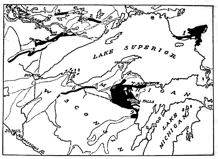
Iron ore. Another important formation is iron ore. Here belong the iron ores of the Mesabi (Minn.), Penokee-Gogebic (Wis. and Mich.), and Menominee (chiefly Mich.) regions (Fig. 352). The ore is in the form of ferric oxide (chiefly hematite, Fe2O3), but in this form it represents an alteration from iron-bearing cherty carbonates, and sediments containing ferrous silicate. The alteration was brought about by ground- water, circulating through the rocks.
The region about Lake Superior yields more iron ore than any other area of equal size in the world. In 1907, the aggregate production of this region was 41,526,579 long tons,[4] which was more than 78 per cent of all that was produced in the United States that year; of this, the Mesabi region produced nearly 27,245,441 tons. The iron ores of this region are partly in the Archean (about Vermilion, Minn.), partly in the older divisions of the Huronian group (about Marquette, Mich.), but most largely in the Animikean (Menominee and Gogebic regions, Mich, and Wis., the Mesabi region of Minn., and some of the ores about Marquette). The following table gives the production in tons for these several regions for certain years preceding 1906:
(Long tons; maxima for each region in Italics.)
| 1890 | 1895 | 1900 | 1905 | 1907 | |
|---|---|---|---|---|---|
| Marquette | 2,863,848 | 1,982,080 | 3,945,068 | 3,772,645 | 4,167,810 |
| Menominee | 2,274,192 | 1,794,970 | 3,680,738 | 4,472,630 | 4,779,592 |
| Gogebic | 2,914,081 | 2,625,475 | 3,104,033 | 3,344,551 | 3,609,519 |
| Vermilion | 891,910 | 1,027,103 | 1,675,949 | 1,578,626 | 1,724,217 |
| Mesabi | . . . | 2,839,350 | 8,148,450 | 20,156,566 | 27,245,441 |
| Total | 8,944,031 | 10,268,978 | 20,564,238 | 33,325,018 | 41,526,579 |
[p. 460]
Thickness of rocks. The thickness of the Huronian systems is difficult of measurement, because of their wide-spread deformation, but if the maximum thickness of the individual formations of different localities is taken, the aggregate thickness is not less than three miles. Such thicknesses, however, are rarely attained in any one locality.
The following section from the Marquette region gives an idea of the sequence of formations in one place, and may be regarded as fairly typical for the region:
- Upper Huronian:
- Michigamme slate and schist. Several thousand feet (maximum) in thickness.
- Ishpeming formation, largely quartzite. 1,500 feet (maximum) thick.
- Negaunee formation or series (slate, schist, jaspilite, iron ore, etc.). 1,500 feet (maximum) thick.
- Middle Huronian
- Siamo slate. 1,200 feet (maximum) thick.
- Ajibik quartzite (sometimes schistose). Nearly 1,000 feet (maximum) thick.
- Lower Huronian
- Wewe slate (including some other sorts of rock). More than 1,000 feet (maximum) thick.
- Kona dolomite (some clastic beds). More than 1,300 feet (maximum) thick.
- Mesnard quartzite. Several hundred feet (maximum) thick.
The Keweenawan System
Constitution, thickness, and relations. In some parts of the Lake Superior region, a fourth system of pre-Cambrian rocks, the Keweenawan, overlies the Upper Huronian. This system is unlike the Huronian systems in being composed more largely of lava-flows than of sedimentary strata.
The lava beds of the Keweenawan constitute its lower and larger part. The earlier flows seem to have occurred on the land. and to have followed one another at short intervals, for the surface of one flow was not sensibly eroded before the next overspread it. Later in the period, the intervals between the flows of lava appear to have become longer, and thin beds of sediment were deposited between successive sheets of igneous rock. Still higher in the system, the sedimentary beds increase in importance until, in the upper part of the system, the lava beds fail altogether, and there follows a succession of sandstones and conglomerates of great thickness.
[p. 461]
In the valley of the St. Croix River, in northwestern Wisconsin and the adjacent parts of Minnesota, there are said to be 65 lavaflows and 5 conglomerate beds in succession, with neither top nor bottom of the system exposed.[5] Some of the igneous rocks, such as the gabbros of the Vermilion [6] and Mesabi [7] regions, are intrusive (laccolithic) . The laccolithic intrusions of the Mesabi region have occasioned extensive metamorphism in the rocks into which they were intruded. The igneous rocks of the system consist principally of gabbros, diabases, and porphyries; but other varieties are also present.
The sedimentary rocks of the system were derived largely from the igneous rock, and their character is such as to indicate that they accumulated rapidly. The thickness of the sedimentary beds has been estimated at some 15,000 feet.
Estimated thicknesses. It is important to note the meaning of the great thicknesses sometimes assigned to sedimentary and igneous formations. In the case of the Keweenawan, for example, the thickness of igneous and sedimentary rocks has been placed as high as 50,000 feet, or nearly ten miles. When great thicknesses of sedimentary rock show signs of deposition in shallow water (or perhaps on land), as in this case, it is commonly inferred that the bottom of the basin of deposition sank during the deposition to an amount corresponding approximately to the thicknesses. In some cases, the amount of sinking assumed exceeds the greatest depth of the oceans. Moreover, if sedimentary rocks accumulated to the thickness assumed, their lower parts would be down where high temperatures prevail, and where the pressure would be such that all crevices and pores would be obliterated, and the rock highly metamorphosed. As a result of uplift and erosion the deeper parts of these thick systems are sometimes exposed, and in many cases do not show the effects of great heat and pressure. In view of these considerations, two positions have been taken by geologists. (1) The correctness of the estimated thicknesses has been questioned, or (2), accepting the estimates, far-reaching theories of [p. 462] crustal deformations have been built upon the supposed subsidence of the surface. It is therefore important to inquire whether the thickness of a series of sedimentary beds is a measure of the depth of the basin in which they were deposited, or of its subsidence while they were being laid down.
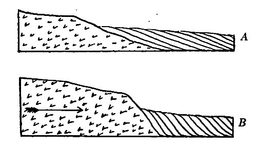
When the sea covers the continental shelf, deposition takes place both on it and on the slope to the abysmal depths of the ocean, and to a slight extent on the bottom of the deep sea. When the sea is withdrawn from the surface of the continental shelf, the shore stands near the upper edge of the abysmal slope, and the heaviest deposition is on this slope. The result may be seen from Fig. 353. Sediment from the land, a, is carried to the sea and deposited on the steep slope. The upper part of the deposits on the steep slope takes place normally in shallow water, and from its exposed position must be subject to the action of currents and waves which give it the characteristics of deposits made in agitated water. These characteristics are interpreted, commonly, as the marks of shallow water.
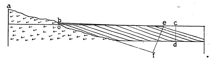
The abysmal slope is usually 2° to 5°, and these are about the angles of dip of the beds laid down on it. Now when these beds have become accessible by deformation and erosion, they are measured along the surface, which may be represented by the line eo, Fig. 353. There are two common modes of measurement: (1) The beds are measured individually, or by groups, at right angles to [p. 463] the bedding-planes, and the sum of the whole ascertained; or (2) the average dip of the beds is taken, and the distance across the truncated edges, eo, is measured, and the thickness of the whole, ef, computed. By comparing the line ef, representing the thickness of the series, with the line cd, the depth of the basin when the beds were deposited, a marked difference is seen. Moreover, the difference may vary so much that there is no necessary relation between the two. If the line ef is short, as it would be if the series had not been built far out, the thickness would be less than the depth of the ocean, cd; but if the line ef is long, as it would be if deposition were continued sufficiently long, the thickness of the series, would be proportionately increased, while cd might remain constant. In other words, the thickness of the series may vary from any fraction of the depth of the basin to a large multiple of it.
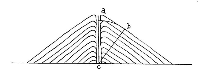
Similar considerations reveal a discrepancy between the vertical measurement and the thickness of the beds deposited subaerially. For example, the thickness of the beds of a volcanic cone is less than the height of the cone which they form, as will be seen from Fig. 354. Lava-flows which congeal as they spread, may give rise to a series of great thickness, without implying contemporaneous sinking. Clastic beds formed by slope-wash may be laid down between the lava-flows without implying subsidence. In the case of the Keweenawan system, a congelation or deposition slope of 5°, extended horizontally a little more than one hundred miles (about half across the Keweenawan basin as it may have been) would give the estimated thickness. To explain the present attitude of the beds, it is necessary to suppose that the basin was compressed laterally, so that the beds were upturned and somewhat sheared upon one another (Fig. 355).
[p. 464]
It is not here affirmed that this is the whole of the explanation of the great apparent thickness of the Keweenawan system, though it seems to throw important light on it. The point here made is merely that great apparent thickness may and does arise in this way, and that inferences and doctrines that overlook this fact have an insecure basis.
Delta deposits furnish especially good illustrations of the point under discussion. If the Amazon were to build a delta out 200 miles, the ocean bottom remaining immovable at an average depth of four miles below the surface, and if the angle of deposition were 2°, the computed thickness of the series, according to current methods of measurement, would be about 7 miles. If the delta were built out 1,000 miles, the computed depth would be 35 miles. If a lake basin 100 miles wide and 1,000 feet deep were filled by sediment, the angle of deposition from either side being 3°, and the filling from each side out to the center, the thickness of the series on each side, measured by the above method, would be 13,800 feet. In this case 13,800 feet of sediment would accumulate in a basin 1,000 feet deep.
[p. 465]
Dwelling on these aspects of the case, we almost reach the conclusion that the thickness of a series of beds, as we usually measure thicknesses where they are great, is independent of the depth of the basin. This, however, is pushing the case too far, for the considerations that have been urged apply only to deposition of the kinds specified, i. e., deposition on appreciable slopes. As originally laid down, the Keweenawan system probably fell far short of covering all of the Animikean.
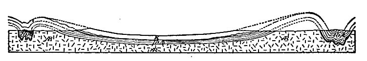
Deformative movements. The sedimentary part of the Keweenawan series has usually been thought to imply marine submergence ; but so far as now known the sediments may have been accumulated in an interior basin and may be more or less subaerial. It was probably during and at the close of this period that the Lake Superior syncline (Fig. 356) was formed, in part at least, and the Keweenawan rocks tilted toward its axis, both from the north and south. It is not to be understood that this syncline has remained a surface depression ever since. On the contrary, it was subsequently filled with sedimentary beds, and the basin occupied by the present lake is the result of later and relatively recent excavation. The deep bowing of the series explains, in part, the distribution of the exposed portions of the Keweenawan system, which comes to the surface chiefly about the Lake Superior syncline.
The deformation of the Keweenawan strata of the region about Lake Superior was perhaps contemporaneous with deformation in other parts of the continent, and these changes are regarded as marking the beginning of the end of the Proterozoic era in this region.
As a result of the deformation at the close of the Keweenawan, some parts of the area where Keweenawan sediments had been [p. 466] deposited were brought into such an attitude as to be subject to erosion, but the changes did not, as a rule, involve great folding of the strata. They are generally tilted, but only locally folded and faulted. In keeping with their structure, neither the sedimentary rocks nor the igneous rocks are greatly metamorphosed.
After the warping which followed the deposition of the Keweenaw an system, the exposed surfaces of this and older systems suffered protracted erosion. Ultimately the land about Lake Superior sank again, and when the sea came back, a new series of sedimentary beds were deposited unconformably on the eroded surface of those which had preceded. The waters of the returning sea teemed with life, for the formation then deposited contains abundant fossils. This abundantly fossiliferous formation, resting unconformably on those which had preceded, is a part of the Cambrian system, the oldest system of the Paleozoic group.
Copper. The Keweenawan system contains the most extensive deposits of native copper known. The metal occurs in the pores and cracks of the igneous rock, and in the interstices between the pebbles and grains of some parts of the sedimentary beds. In the conglomerate at some of the richer mines, the copper is so abundant as to be an important cementing material of the rock. In its present form, it is believed to be a precipitate from aqueous solution, and to have been concentrated by ground-water. The original source of the metal was probably the igneous rock itself.[8]
In 1875 the Keweenawan formation of northern Michigan yielded 16,089 tons of copper, or about 90 per cent of all that was produced in the United States. In 1905, the same area yielded 102,807 tons, but this was only about 26 per cent of the copper produced in the country that year.[9]
General Considerations Concerning the Lake Superior Proterozoic
Duration of time. It is difficult to conceive of the great lapse of time involved in the history of the Proterozoic era. The estimates give an aggregate thickness of more than 30,000 feet for the [p. 467] sedimentary rocks of the Proterozoic systems. The accumulation of so much sediment would in itself mean a vast lapse of time, and when it is remembered that the four systems are separated from one another by unconformities, each of which may represent as much time as that involved in the accumulation of a system, it will be seen that the duration of the Proterozoic era was exceedingly long, possibly comparable to all succeeding time. The duration of the era cannot be stated in numerical terms, but it would appear that it should be spoken of in terms of tens of millions of years, rather than in terms of a lesser denomination.
Destruction of rock implied. Thick beds of sediment mean the destruction of a still larger volume of older rock, for much of the more soluble part of the rock destroyed does not appear in the sedimentary formations. It is important to note that a large part of the Proterozoic sediments were produced by the mature decomposition of older rocks. It is scarcely too much to infer that the materials of the larger part of the great formations of quartzite, slate, and shale first became soils on the surface of the parent areas, and that their removal was at a rate comparable to that of their renewal by rock decay. This point is ,of significance because it implies the existence of climatic conditions and geologic processes comparable to those of the present time.
If the Archean lands in the vicinity of Lake Superior were high enough at any time to furnish the thick sediments of the Proterozoic, their height would perhaps have surpassed any existing elevation, but is is not probable that such elevations existed at any time. It is more probable that as erosion proceeded, the land reacted by rising slowly, or that the sea bottom sank, drawing off the waters and leaving the land relatively higher. In this way, degradation and elevation may have been in progress at the same time, and the one process may never have got far ahead of the other. It is believed by some geologists that the removal of sediments in large quantities from the land would result in its rise, and that their deposition on the sea bottom would cause that to sink. The doctrine that the surface of the lithosphere sinks and rises under increase and decrease of load is one phase of the general theory of isostasy.
[p. 468]
Succession of events. Reviewing the succession of events in the Lake Superior region, we find (1) that the land was high enough, after the Archean rocks came into existence and were deformed, for its surface to suffer prolonged erosion, but that the sites of the earliest sedimentation are unknown. (2) The Archean land then sank or was so eroded or deformed as to permit the deposition of the Lower Huronian sediments on portions of its eroded surface. (3) The area of the former Archean land, together with some part of the Lower Huronian system about it, was then brought into such an attitude, presumably by crustal warping, that it was subject to a long period of erosion, with contemporaneous sedimentation elsewhere. During the time of the deformation, the rocks involved were somewhat metamorphosed. (4) Again the land seems to have sunk, allowing the sea (or at any rate, conditions for deposition) to cover a large part of the territory which had been subject to erosion, and to deposit upon its eroded surface the sediments of the Middle Huronian system. (5) After this long period of sedimentation, certain tracts seem to have emerged, exposing the landward border of the Middle Huronian system, and all the older rocks not covered by it, to erosion. The emergence of areas of Middle Huronian sedimentary formations was accompanied by some deformation and metamorphism. (6) This period of erosion was followed in turn by another period of submergence, when sediments (the Animikean) were laid down again in the Lake Superior region, this time on the eroded surface of the Middle Huronian or some older system. (7) Deformation, accompanied by emergence and followed by erosion, succeeded this third period of Proterozoic sedimentation. (8) Flows of lava of great magnitude were then poured out upon the surface of the land over considerable areas, and intruded into existing terranes. Before the outflows ceased, sedimentation began again in the region, and soon predominated, the lavas and sediments making the Keweenawan system. (9) After the deposition of this system, much of it was exposed to erosion.
This succession of events implies repeated changes of relative level of land and sea in the Lake Superior region during the Proterozoic era. We shall see that such changes are confined neither [p. 469] to this time no? to this region. Geological history makes it clear that changes in the relations of sea and land are among the notable events of the earth’s history, even to the present time. Since many other changes are dependent on them, they are believed to furnish the best basis for the subdivision of geological history.
It is not now possible to determine the extent of the crustal oscillations which took place during the Proterozoic era; but enough is known of the extent of the area in North America at the close of the Proterozoic to make its cartographic representation instructive. The area not covered by the early Cambrian beds (Fig. 357) was land at this time, and the continent was probably much more extensive than this statement implies.
Metamorphism. The Lower Huronian rocks are, on the whole, more highly metamorphosed than the Middle Huronian, and these are more generally altered than the Animikean, while the Keweenawan formations are metamorphosed scarcely at all. On the other hand, the Animikean beds are locally as highly metamorphic as the Lower Huronian, indicating intense dynamic action, at least locally, after the deposition of the third great system. Since different sorts of rock behave differently under dynamic action, it follows that some beds are much more highly metamorphic than others associated with them, even though subjected to the same forces.
There is scarcely a phase of metamorphism which the Proterozoic rocks do not show. The schists, slates, and gneisses are especially the product of dynamic metamorphism; the quartzites are the products of extreme consolidation by cementation; the iron ore is the product of metasomatism, effected by ground-waters, while other phases of metamorphism are due to the heat of intruded rock. It is not to be understood that the metamorphism of any considerable body of rock is effected by any one process alone. Dynamic action, which seems on the whole the most important factor in metamorphism, always generates heat, and high temperature, especially in the presence of water, facilitates chemical and mineralogical change. So, too, in the case of igneous intrusions, there is often great dynamic action as well as great heat, and water, an agent of chemical change, is always present.
[p. 470]
[p. 471]
Sequence of events elsewhere. A series of events consonant but not necessarily identical with those of the Lake Superior region was probably in progress about every other area of Archean rock, during the Proterozoic era; but it does not follow that about every other Archean land area four great systems of rocks were laid down during this long era. About some such areas there may well have been three, or two, systems of Proterozoic rocks instead of four, while about others, continuous sedimentation may have been in progress from the beginning of the Huronian period to the end of the Keweenawan.
Proterozoic Rocks in Other Regions
Pre-Cambrian sedimentary formations occur in many other parts of North America, in relations to the Archean similar to those already described. On the whole, it may be said that they resemble the rocks of the Proterozoic systems about Lake Superior as closely as could be expected under the general principles already set forth. Some of the more important occurrences of Proterozoic rocks outside the Lake Superior region are the following: (1) In an extensive area north of the Great Lakes; (2) in the eastern provinces of Canada; (3) in the Adirondacks; (4) in isolated patches in the Mississippi basin, in Wisconsin, northwestern Iowa and adjacent parts of Minnesota and South Dakota, in the Black Hills of South Dakota, in southeastern Missouri, and in Oklahoma; (5) in Texas; (6) in the Piedmont belt of the eastern part of the United States; and (7) at various points in the Cordilleras.
In some of these localities, the rocks are chiefly sedimentary or meta-sedimentary, while in others they are partly or even largely igneous. Thus in the Black Hills, the Proterozoic rocks consist of closely folded meta-sedimentary rocks, such as mica slates, quartzites, schists, etc., and intrusive igneous rocks. From the granite intrusions, the largest of which is eight or ten miles [p. 472] long and nearly as broad, numerous dikes penetrate the clastic beds, and furnish good illustrations of the metamorphosing effects of igneous intrusions.
In the Adirondack region, Pre-Cambrian rocks make up a large part of the Adirondack Mountain mass. They belong to two groups: (1) The central mass of the mountains, consisting of igneous rocks which were intruded into (2) a series of pre-Cambrian sedimentary rocks which surround and cover the base of the igneous mass.
The Cordilleran region. The axial cores of many of the older mountain ranges of the West are believed to be of Archean rock. In many of them there are thick series of sedimentary or meta-sedimentary rocks overlying the Archean and surrounding its outcrops, overlain in turn by Cambrian or younger strata. Rocks referred to the Proterozoic are found in the Medicine Bow and some other mountains of Wyoming; in the Bridger, Little Belt, Lewiston, and Livingston ranges of Montana, where some of them are fossiliferous; in British Columbia; in the Wasatch and certain lesser ranges of Utah; in several of the ranges of Nevada and Colorado, and in the Grand Canyon of the Colorado in Arizona. In most if not all of these localities, sedimentary beds predominate, but are accompanied by igneous rocks which are in part contemporaneous. The thickness of the Proterozoic rocks in these various localities is often great, and in most places they are unconformable on their base, and beneath overlying formations. In much of the northwest, however, there is conformity between the Proterozoic and the Lower Cambrian, according to present interpretations.
In the Canyon of the Colorado (Arizona) the pre-Cambrian formations are well exposed. The Proterozoic (Grand Canyon) group, more than 10,000 feet in thickness, here rests unconformably on the Archean, and is in turn covered unconformably by the Cambrian. The group is itself divisible into two systems by a slight unconformity. Here, as in Montana, a few fossils have been found.
In the eastern part of the United States.[10] There are large areas of metamorphic rock in the eastern part of the United States, [p. 473] which were formerly classed as Archean. Their position is shown in Fig. 341. This belt of metamorphic rocks contains formations that were sedimentary, and those that were igneous. Some of them are probably Proterozoic, but the Proterozoic rocks here have not been generally differentiated from the Archean on the one hand, and from metamorphic Paleozoic rocks on the other.
Summary. While the correspondence of the Proterozoic rocks in these various regions with those of the Lake Superior region is not generally very close, it may be pointed out again that close correspondence is not to be expected, even if the rocks of different localities were contemporaneous in origin. The phases of sedimentation taking place about any land mass at any time are largely dependent upon the height of the land, the freeness of the exposure of its coasts, the climate, and the character of the formation suffering erosion. These various factors were as likely to be dissimilar as similar about the various centers of sedimentation. Igneous rocks form a not inconsiderable part of the Proterozoic systems, and there is no apparent reason why igneous activities in different regions should correspond either in time or in the nature of their products. Even deformations of the crust, which are the basis for the separation of the group into systems, need not have corresponded in different regions. It follows (1) that the number of systems bounded by unconformities wdthin the Proterozoic, may not be the same in all regions; (2) that the thicknesses of the various systems may vary within wide limits; (3) that there need have been no close correspondence in the sorts of rock in different regions at the outset; and (4) that they may have been metamorphosed unequally since their deposition. The dissimilarity of the Proterozoic in different regions, as suggested by the preceding sketch, was, therefore, to have been anticipated.
Proterozoic Formations in Other Continents
Proterozoic formations are believed to exist in all continents. In more than one country where they have been studied, the preCambrian sedimentary rocks are thought to belong to at least two systems, separated by unconformities. It is worthy of note that in Sweden, as about Lake Superior, iron ore occurs in these formations.
[p. 474]
¶ Life During the Proterozoic Era
While the Proterozoic rocks do not generally contain fossils, there can be no doubt that life existed during the era. The lines of evidence are as follows: (1) The carboniferous shales, slates, and schists indicate the existence of life; (2) the occasional fossils[11] (especially in Montana and in the Grand Canyon of the Colorado) demonstrate the existence of life at that time; (3) the iron ore of these systems, although not originally deposited in its present form, has been thought to imply the existence of life; and (4) the limestone. It should be noted that limestone occurs near the base of the Lower Huronian. This rock was formerly regarded as demonstrative of the existence of life, but in recent years the belief has gained ground that considerable formations of limestone may have originated by precipitation from sea-water. This origin is suspected for many limestone formations which are free from fossils, and if the hypothesis is applicable to any extensive formation of limestone, it may be applicable to that of the Proterozoic. But even without reliance on this sort of rock, the occasional fossils leave no doubt of the existence of life in this era. The best-preserved fossils are those of Eurypterus-like crustaceans. There are also tracks of two genera of worms, and other undetermined forms. Besides these certain fossils, there are obscure forms which appear to be referable to brachiopods and pteropods. It is significant that the oldest definite fossils yet found are forms well up in the animal kingdom and that they occur (in Montana) 9,000 feet below the unconformity between the Proterozoic and the Cambrian.[12]
¶ Climate
Since inferences concerning the climate of any period are drawn chiefly from fossils, and since fossils are exceedingly rare in the Proterozoic strata, they afford little warrant for any conclusion concerning the climate of the era. It may be noted, however, that conglomerate beds which have been interpreted as glacial are [p. 475] found in the Proterozoic of Canada,2 that glacial beds of somewhat uncertain age — late Proterozoic or early Cambrian — are also reported from Norway,[13] and that glacial formations of early Cambrian (of late Proterozoic) age exist in China.[14] Glacial formations are singularly out of harmony with the conceptions of the climate of early geologic time which have prevailed until recent times.
Map studies. Map studies should be carried on in connection with the chapters on the Archeozoic and Proterozoic. For this purpose, numerous folios of the U. S. Geological Survey are especially serviceable; so also are some of the maps and sections in various Reports of the same Survey, and of certain State Geological Surveys.
Some of the folios which are especially valuable for this purpose are the following; Arizona, Bradshaw Mountain, Clifton; Colorado, Needle Mountains, Ouray, Rico; District of Columbia, Washington; Maryland, Patuxent; Michigan, Menominee; North Carolina, Asheville, Cranberry, Mount Mitchell, Nantahala, Pisgah; Virginia, Harpers Ferry; Wyoming, Absaroka, Bald Mountain-Dayton, Cloud Peak-Fort McKinney, Hartville, Sundance. These folios show the structure and the relations of the Archean to the Proterozoic (Algonkian) at divers points, and the relations of both to younger rocks. These relations should be noted. The Structure Section Sheets of the folios afford the means for determining, more or less closely, the sequence of geologic events in the region concerned, such as the dates of deformations, the dates of igneous intrusions or extrusions, the dates of faulting, etc. The texts of the folios give brief descriptions of the formations, and concise statements concerning the sequence of geologic events in the regions concerned.
¶ Notes
Proterozoic, as here used, is a synonym for Algonkian as used by the U.,8. Geol. Surv. ↩︎
Jour. Geol., XIII, p. 161. ↩︎
The name Huronian comes from the area north of Lake Huron, where these formations were first differentiated. ↩︎
Mineral Resources of the United States. ↩︎
Hall, Bull. Geol. Soc. Am., Vol. XII, pp. 313-340. ↩︎
Elements, Mono. XLV, U. S. Geol. Surv. ↩︎
Leith, Mono. XLIII, U. S. Geol. Surv. ↩︎
For discussions of the copper, sco Irving and Van Ilise, Mono. V, U. S. Geol. Surv., and Chamberlin, Vol. I, Geology of Wisconsin. ↩︎
Mineral Statistics for 1905, U. 8. Geol. Surv. ↩︎
See Bull. 86, U. S. Geol. Surv., and folios, U. S. Geol. Surv. ↩︎
For summary of knowledge concerning pre-Cambrian fossils, see Walcott, Bull. Geol. Soc. Am., Vol. 10, pp. 199-244. ↩︎
Coleman, Jour. Geol., Vol. XVI, p. 149. The evidence of the glacial character of these beds is open to question. ↩︎
Reusch, Norges geologiske Undersoegelse : Det nordlige Norges Geologi, 1891. Also Strahan, Quar. Jour. Geol. Soc, Vol. 53, 1897, pp. 137-146. ↩︎
Willis, Year-Book No. 3, Carnegie Inst., p. 382. ↩︎