Public domain
[p. 338]
The outer parts of the lithosphere are subject to a variety of movements; some very rapid and some very slow, some very slight and some very great, some limited to small areas, some affecting extensive tracts, and some involving the whole earthbody. For practical treatment, they fall mainly into two groups, (1) the small and rapid, and (2) the great and slow. Sudden movements of local masses, such as avalanches and landslides, are put in the first class. Minute and slow movements, unless they rise to importance by long continuance, are here neglected.
¶ Minute and Rapid Movements
The crust of the earth is in a state of perpetual tremor. For the most part, these tremors are too slight to be sensible, though detectable by delicate instruments. Some of them precede or follow sensible vibrations, such as earthquakes, but more of them have no connection with violent movements. Many spring from the ordinary incidents of the surface; waves, waterfalls, winds, tides, rainfall, the rise and fall of atmospheric pressure, the tread of animals, the rumble of traffic, the blasts of mines, and many other processes. These are serviceable for demonstrating the elastic nature of the crust, but are here neglected.
Earthquakes [1]
When tremors of appreciable violence spring from sources within the earth, they are classed as earthquakes. The causes are various; [p. 339] the most prevalent is probably the fracture of rocks and the slipping of strata on each other in the process of faulting. To the same class belong movements due to slumping, which is, in reality, superficial faulting. Tremors often attend volcanic eruptions. Such tremors are attributable to the sudden fracture and displacement of rock by the movements of lava, or by the expansion due to rapid and unequal heating. They are often attributed to the sudden generation or cooling of steam in underground conduits, crevices, and caverns. Earthquake vibrations also spring from the collapse of the roofs of subterranean caverns.
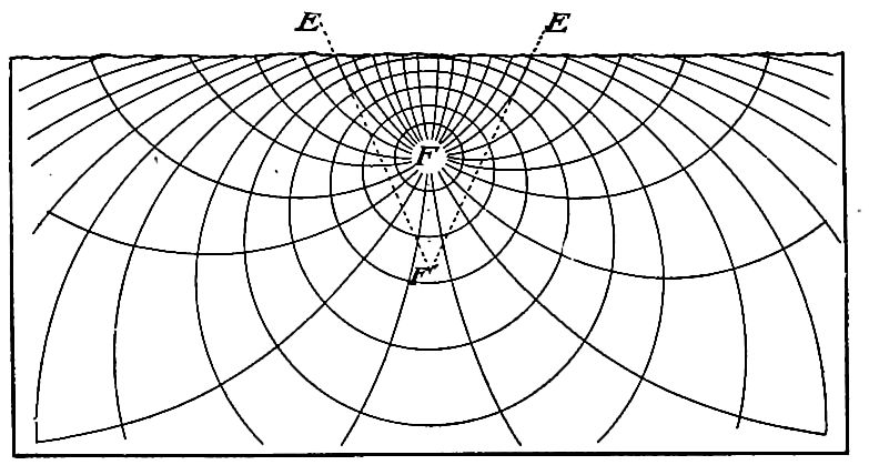
Points of origin; — foci. It is probable that nearly all earthquake movements start at depths of less than ten miles, and most of them at depths of less than five. The earlier estimates which placed some of the foci deeper, seem to be defective. The depth of the sources of disturbance is usually estimated by noting the directions in which bodies are thrust during an earthquake, plotting these directions, and projecting them backwards to their underground crossings (lines EF’,Fig. 272). This only gives a [p. 340] rude first approximation to the location of the focus (point, line, or plane), and all estimates made in this way are subject to important corrections.[2]
The amplitude of the vibrations. From the disastrous effects of earthquakes it might be inferred that the vibrations have large amplitudes; but it is chiefly their suddenness that makes them effective. Except at their points of origin, they are usually only a fraction of a millimeter in amplitude, and seldom exceed a few millimeters. A sudden shock with an amplitude of 5 or 6 millimeters is sufficient to shatter a chimney. It is the oscillation of the rock particles transmitting the vibrations that is here meant, not the movement of objects on the surface, which is often much greater. Just as a marble lying on a floor may be made to bound several inches by a slight tap of a hammer some distance away, so a sufficiently sudden rise of the earth-surface for a fraction of an inch only, may project loose bodies many feet.
[p. 341]
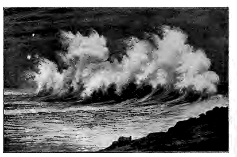
Destructive effects. The disastrous effects of earthquake shocks result from (1) the suddenness and strength of rather minute vibrations of earth-matter, and from (2) the freedom of motion of the bodies affected. The deeper rocks, where sensibly continuous, transmit seismic vibrations without appreciable disruptive effect so far as known (though the origin of crevices has been assigned to this cause) ; but bodies at the surface are fractured, overturned, and notably displaced. The tap of a hammer sends an almost imperceptible vibration along the floor, but this vibration throws well into the air the glass ball beneath which it runs. Similarly the minute seismic vibrations travel miles from their origin through continuous substance with little result, and yet may then hurl a loose or unstable body to destruction. Earthquake waves striking [p. 342] the sea-border may thrust the waters off shore, and the return wave may overwhelm the coast (Fig. 276). Sea-waves doubtless arise also from a sudden stroke of seismic vibrations on the seabottom.
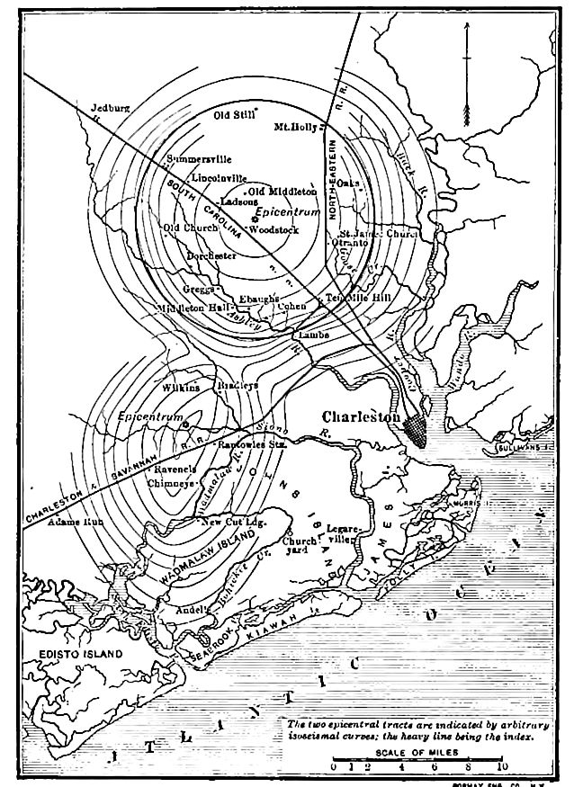
Direction of throw. Immediately above the point, line, or plane of origin (epicenirum or epi-focal point, line, or plane), bodies are projected upwards. Elsewhere at the surface plane, the thrust is oblique. The destructiveness commonly increases for a certain distance from the epi-focal point, line, or plane, and then diminishes. Lines drawn through points of equal effect (isoseismals,Fig. 277) are not usually circles or regular ellipses, and their departures from these forms represent differences of elasticity, etc. As most earthquakes originate from lines, planes, or masses, rather than points, there are differences in the intensity of vibration at different points on the lines or planes of origin, and these differences introduce inequalities in propagation and in surface effects.
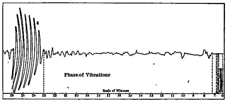
Rate of propagation. The progress of a seismic wave varies appreciably. The violent vibrations on the surface near the place [p. 343] of origin are the most irregular, and the stronger vibrations generally have greater speed than the weaker ones. The vibrations propagated to great distances through and around the earth are more uniform in rate, being about 1.85 miles (3 km.) per second for those which follow the surface, about 5.7 miles (9.17 km.) per second for the speedier set that goes through the earth, and about 3.9 miles (6.25 km.) for the second set that goes through the earth.[3]
[p. 344]
Distribution of earthquakes. Over large portions of the globe, severe earthquakes are rare, but in certain regions they are, unfortunately, frequent. In general, earthquakes are likely to be rather frequent where geologic changes are in rapid progress, as along belts of young mountains where the stresses are not yet adjusted, or at the mouths of great streams where deltas are accumulating, or about volcanoes where temperatures and strains are changing, or on the great slopes, particularly the submarine slopes, where adjustments to inequalities of stress are in progress. Not a few, however, occur where the special occasion is not obvious.
The Geologic Effects of Earthquakes
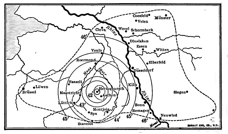
Geologically, earthquakes are of less importance than many gentler movements and activities. Disastrous as they sometimes are to human affairs, they leave few distinct marks which are more than temporary. During the passage of notable earthquake [p. 345] waves the solid rock is probably often fractured, though the fractures are rarely observable at the surface where it is covered by deep soil. Elsewhere the crevices are readily seen, especially if they gape. In a few instances, surface-rock has been seen to be thoroughly shattered after the passage of an earthquake, as in the Concepcion earthquake of 1835.[4] Joints which were closed before, are often opened during an earthquake. Thus in northern Arizona, not far from Canyon Diablo, there is a crevice traceable for a considerable distance which is said to have been opened during an earthquake (Fig. 281). Locally, it gapes several feet. During an earthquake which shook the South Island of New Zealand in 1848, “a fissure was formed averaging 18 inches in width, and traceable for a distance of 60 miles, parallel to the axis of the adjacent mountain chain.”[5] The development of fractures or the opening of joints is sometimes accompanied by faulting. This was the case in Japan during the earthquakes of October 28, 1891, when the surface on one side of a fissure, which could be traced for 40 miles, sank 2 to 20 feet (Fig. 282). In this case there was also notable horizontal displacement, the east wall of the fissure being thrust locally as much as 13 feet to the north.[6]
[p. 346]
[p. 347]

[p. 348]
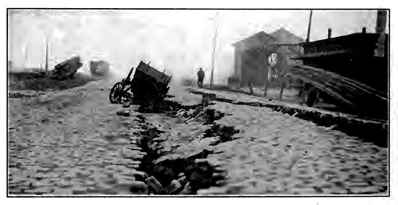
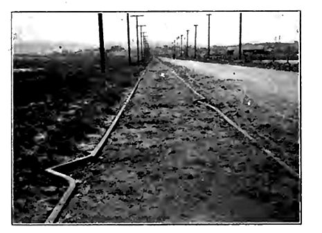
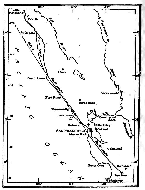
Changes of surface. Circular surface openings or basins are sometimes developed during earthquakes. This was the case during the Charleston earthquake of 1886[7] and similar effects have been noted elsewhere. These openings often serve as avenues of escape for ground-water, gases, and vapor. They are commonly supposed to be the result of the collapse of caverns, of other subterranean openings, or the compacting of rock, the collapse often causing the forcible ejection of water. Such openings are likely to be formed only where the surface material is incoherent. Sand cones and craterlets are sometimes developed (Fig. 283). During the California earthquake of 1906, the ground was much broken along the line of the fault which caused the shock (Fig. 284). Earthquakes sometimes dislodge masses of rock in unstable positions, as on slopes or cliffs, and occasion slumps and landslides.
Effects on drainage. The fracturing of the rock may interfere with the movement of ground-water. After new cracks are developed or old ones opened or closed, the movement of groundwater adapts itself to the new conditions. It follows that springs sometimes cease to flow after an earthquake, while now ones break out where there had been none before. The character of the water [p. 349] of springs is sometimes changed, presumably because it comes from different sources after the earthquake. Joints may be so widened as to intercept rivulets. Where faults accompany earthquakes, they may occasion ponds or falls where they cross streams.[8]
Effects on standing water. Some of the most destructive effects of earthquakes are felt along shores. The great sea-waves of the Lisbon earthquake (1755) and of the earthquake on the coast of Ecuador and Peru in 1868, were most destructive. Such waves have been known to advance on the land as walls of water 60 feet in height. They are most destructive on low coasts where the water may sweep over great areas of land. The great loss of life during an earthquake is often caused by such waves. Lakes are also affected by earthquakes, but their waves are much feebler than those of the sea, and are not often very destructive.
Earthquake shocks are sometimes remarkably destructive to the life of lakes and seas. Thus during the Indian earthquake of [p. 350] 1897, “fishes were killed in myriads as by the explosion of a dynamite cartridge and for days after the earthquake the river (Sumesari) was choked with thousands of dead fish and two floating carcasses of Gangetic dolphins were seen which had been killed by the shock.”[9] This wholesale destruction of life is of interest since the surfaces of layers of rock, often of great age, are sometimes covered with fossils in such numbers as to indicate that the animals were killed suddenly and in great numbers, and their bodies quickly buried. It has been suggested that such rock surfaces may perhaps be memorials of ancient earthquake shocks.[10]
[p. 351]
Changes of level. Permanent changes of level sometimes accompany an earthquake. Thus after the earthquake of 1822 “the coast of Chili for a long distance was said to have risen 3 or 4 feet.” [11] Similar results have occurred on the same coast at other times, and on other coasts at various times. Depression of the surface is perhaps even more common than elevation. Thus on the coast of India all except the higher parts of an area 60 square miles in extent were sunk below the sea during an earthquake in 1762. Widespread depression in the vicinity of the Mississippi in Missouri, Arkansas, Kentucky, and Tennessee accompanied the earthquakes of 1811 and 1812. Some of the depressed areas were converted into marshes, while others became the sites of permanent lakes. Reelfoot Lake, mainly in Tennessee, is an example. Change of level is often involved in faulting, and faulting is probably rather common in connection with earthquakes.
Changes of level are not confined to the land. Where earthquake disturbances affect the sea-bottom in regions of telegraph cables, the cables are often broken. In such cases notable changes have sometimes been discovered and recorded when the cables were repaired. In one instance (1873) the repairing vessel off the coast of Greece [12] found about 2,000 feet of water where about 1,400 feet existed when the cable was laid. In another instance (1878) the bottom was so “irregular and uneven for a distance of about two miles, that a detour was made and the cable lengthened by five or six miles.” In still another case (1885) the repairing vessel found a “difference of 1,500 feet between the bow and stern soundings.” These records point to sea-bottom faulting on a large scale.
¶ Secular Movements
The minute and momentary oscillations of earthquakes are very unlike the slow movements of continents or ocean basins, or even [p. 352] the slow wrinkling of mountain folds. Rivers may wear down their channels across a mountain range as fast as it rises athwart them, and the movements of continents are even slower; but far apart as these contrasted movements are, they are doubtless associated in cause; and the earthquake shock is often merely an incident in the formation of a mountain range or in the movement of a continent.
The great movements may be classed (1) as continent-making (2) plateau-forming and (3) mountain-folding; or as (1) general (epeirogenic) or (2) as concentrated (orogenic) ; as (1) vertical and (2) horizontal, and dynamically, as (1) thrust and (2) stretching movements. These distinctions are analytical conveniences but are not exclusive of one another, for continental movements often involve mountain-making, vertical movements usually involve horizontal movements, and stretching usually attends the outer bends of thrust folds.
Present movements. Observations on seacoasts show that some shores are slowly rising and some slowly sinking, relative to the ocean-level. It is not certain what these movements are relative to the center of the earth. All parts of the coast may be sinking, some faster than others, while the ocean-surface goes down at an intermediate rate; or, theoretically, all parts may be rising, but at different rates. Some lands may be actually rising relative to the center of the earth, and others sinking, while the ocean-level has an intermediate movement or none at all. We are accustomed to take the sea-level as a standard, as though it were stationary, which is probably not the fact. A general shrinkage of the earth is probably going on, carrying down the surface of both land and sea. It is possible that the shrinkage is so great that upward warpings and foldings do not usually equal it, and hence nearly all movement may be really toward the earth’s center. This seems to be implied by the crumpling of the surface. The popular disposition is to regard earth movements generally as “upheavals.” There is also a predilection for regarding the rigid land as moving, and the mobile sea-level as fixed. In reality, the sea is an extremely adaptive body which settles freely into the irregular hollows of the lithosphere and is shifted with every warping of the [p. 353] latter. Whatever change affects the capacity of the abysmal basins’ affects the sea-level. If the basins are increased, the sea settles deeper into them; if they are decreased, the sea spreads out more widely on their borders. The one thing that gives a measure of stability to the sea-level is the fact that all the great basins are connected, and so an average is maintained. For this reason the sea-level is the most convenient basis of reference, and has become the accepted datum-plane, notwithstanding its instability and its complete subordination to the lithosphere. If there were some available mode of measuring the distance of surface points from the center of the earth, it would give absolute data and would reveal much that is now uncertain respecting the real movements of the surface.
The classes of movements. The existence of land depends on protuberances on the surface of the lithosphere. If the lithosphere were perfectly spheroidal, water would cover it everywhere to a depth of nearly two miles. To maintain the existence of land the protuberances must be renewed from time to time; otherwise the land would in time be degraded to the lowest depths of wave action. The renewal has been brought about again and again in geologic history by movements that have restored the protuberances. With every such movement, the oceans seem to have withdrawn more completely within the basins, while the continents have stood forth more prominently until again worn down. This renewal of protuberances appears to have been periodic in its great features, with long intervals between. In these intervals, the land was worn down by rivers, waves, etc., and the sea crept out upon the lower parts of the continents, forming continental shelves. Before complete submergence was effected, however, renewed deformations checked the progress of submergence and rejuvenated the continents.
Beside the great movements, numerous minor warpings or oscillations of the surface have been in almost constant progress. Some of these are probably only incidental features of the larger movements made necessary to complete the adjustment to the smaller stresses left after the great stresses are relieved, but others are probably due to local and special causes of the lesser sort.
[p. 354]
Minor Movements
Gentle movements seem to have affected nearly every portion of the surface of the lithosphere at nearly all stages of its history. They have often had much to do with the particular places and forms of deposits. Slow relative sinkings of sea-borders have permitted deposition to go on in shallow water for long periods without building the bottom up into land, and slow relative swellings of land tracts have permitted the agents of erosion to get sediments for such deposits. Such movements have also shifted the borders of lands and seas, and with them, the areas of erosion and deposition. These movements may have amounted to a few inches, a few feet, or a few fathoms per century. They are sometimes reciprocal, one area being bowed up while another near by is bowed down. How far these are merely local or regional, due to loading, unloading, changes of temperature, and other local causes, and how far they are the milder phases of the great body movements of the earth or the incidental creep arising from these, it is difficult to decide.
The Great Periodic Movements
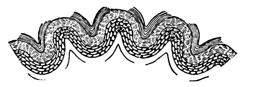
I. Mountain-folding. Along certain tracts, the shell of the earth has been folded into wrinkles, thus forming folded mountains. The shell so folded, judged from the nature of. the folds, seems to be quite superficial, reaching only a few miles in depth. Sometimes the strata were very closely folded, and even intensely crumpled. The forces that caused the folding took the form of lateral thrusts. The folds themselves were usually lifted, showing that there was an upward component to the horizontal thrust, but the latter was the dominant factor. The folds were crumpled outward rather than inward, which implies that there was crowding below, rather than shrinkage. The folds are sometimes nearly upright and symmetrical, and sometimes inclined and asymmetrical, as illustrated in Chapter XL When the folds Jean, it is commonly inferred that the active thrust was from the side of the gentler slope, and pushed the fold over toward the resisting side, but this is not always a safe inference, for the original attitude of the beds has much to do with the way they yield. Systems of [p. 355] folded mountains usually embrace a series of roughly parallel folds, the whole forming an anticlinorium (Fig. 286).
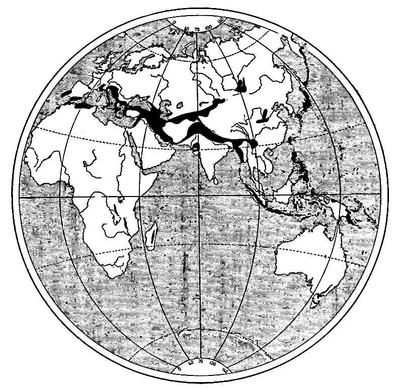
Distribution of folded mountain systems. The location of folded mountains is so often near the borders of the continents that the relation is probably significant, but there are very notable exceptions. Among these are the Urals, the complex series that stretches from the Pyrenees to the Hindu Kush, the Central Asian chain which embraces the Sayan, the Altai, and the Tien Shan, and many minor ranges.
Folding movements had extraordinary prevalence in the early ages. The Archean rocks are almost universally crumpled, often in the most intricate fashion, and the proterozoic formations are much folded. After the inauguration of the well-known sedimentary eras, folding appears to have taken place chiefly at long intervals, and for any given period to have been concentrated along certain tracts. The Appalachians and the Juras are types.
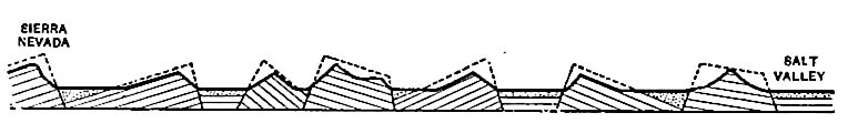
2. Plateau-forming movements. An important phase of massive movement was the relative settling or raising of great blocks or segments as though by vertical rather than horizontal forces. The great plateaus are examples of the protrusive phase of this action; perhaps the great “deeps” of the ocean bottom, and some of the basins or troughs (Graberi) on the continents, are examples of the depressional phase. The plateaus usually embrace numerous [p. 356] blocks which were moved in different degrees, and were often tilted individually (Fig. 287). At the surface, these blocks are separated by fault-planes, but below, some of the faults pass into flexures. Most such flexures are monoclinal. Plateau-forming movements are to be compared with the continent-forming movements, rather than with mountain-foldings, differing from the former chiefly in magnitude. Plateaus may be regarded as parts of a continental mass that have suffered special additional movement. Plateaus stand in some such relation to continents, as one fault block of a plateau does to the whole plateau. They are probably to be regarded as the results of body deformations, while the mountains are the result of the folding of the shell, affecting only a few miles of the outside.
3. Continent-forming movements. These are widespread movements affecting large masses of the body of the earth, if not its whole outer portion. Two or more continents are often affected by similar movements at the same time, and it is the view of many geologists that all continents are usually affected simultaneously by movements of a like kind, resulting in emergence or submergence, while the ocean basins are affected by movements of the opposite phase. These are thus thought to be body movements. The depression of the basins and the relative elevation of the continents are regarded as reciprocal parts of a world-wide adjustment. While well supported both by observation and theory, this view cannot be said to be universally accepted. Movements of this class seem to have started early in the history of the globe, and to have been renewed from time to time, rejuvenating the continents and developing the basins. Under the view that the earth is essentially solid throughout, these movements are regarded as deepseated deformations, while the mountain folding is regarded as but the wrinkling of the earth’s skin to fit its changed body.
Downward movements are regarded as the primary ones, and horizontal movements as a necessary result of them. The primary cause is believed to be an increase of the density of the earth, actuated by gravity and the molecular and sub-molecular attractions. The master movement is thought to be the sinking of the great basins, whose specific gravity is greater than that of the continents. [p. 357] The reasons for this will be set forth later. If the ocean basins and the continental platforms, respectively, be regarded as the surfaces of great segments of the earth all of which are crowding toward the center, the stronger and heavier segments may be conceived to take precedence, squeezing the weaker and lighter ones between them. The consequent swelling up of the lighter segments accounts for the relative protrusion of the continents.
The area of the more depressed segments is almost exactly twice that of the protruding ones, if we count the 10,000,000 square miles now covered with shallow water as parts of the continental platforms. Roughly approximated in millions of square miles, the major depressed segments are as follows: The Pacific 60, the Indian 27, the South Atlantic 24, the North Atlantic 14, leaving 8 for minor depressions. The elevated segments are the Eurasian 24, the African 12, the North American 10, and the South American 9, leaving 10 for the minor blocks.
The downward movement of the master segments and the crowding of the smaller and lighter segments between them involves deformations of the latter. Those that spring from the deeper, more massive crowdings affect the continental platforms generally, or at least broadly, while the crowding of the more superficial parts affects the continents more locally. The great plateaus lie chiefly at angles in the great segmental movements, where special crowding naturally arises. It is obvious that on the borders of the continental segments there would be special bowings, and this tallies with the archings common on border tracts, even when no folding takes place. The shell of the earth is free at the surface, and as a result, folding and faulting are the modes of easiest accommodation, while in the deeper parts which are under great pressure, the mass must be deformed throughout.
The periodicity of the movements is assigned to the rigidity of the thick, massive segments which must be deformed to accomplish a readjustment. Because of this rigidity, stresses may accumulate for a period until they come to equal the resistance opposing them, after which a further increase of the stresses brings on a yielding and forces a readjustment. When masses, under stress, once begin to yield in the direction of the free surfaces, their attitudes [p. 358] for resistance become less favorable, and hence the stress compels continued yielding until it is fully eased. After this a period is required for stress to accumulate, sufficient to produce another general deformation. Meantime the minor stresses that may remain, or may be produced by the great deformations, tend to ease themselves and thus give rise to the minor movements (p. 354). Other minor movements are doubtless due to local causes.
The extent of the movements. Between the highest elevation of the land and the lowest depth of the ocean, there is a vertical range of nearly twelve miles. From the Tibetan plateau, where a considerable area exceeds three miles in height, to the Tuscarora deep, where a notable tract exceeds five miles in depth, the range is eight miles. This may fairly represent the vertical range of differential movement of large areas. The average height of the continents is about three miles above the average depth of the oceans, and this may be taken as the differential movement of the great segments.
If the protruding portions of the lithosphere were graded down and the basins graded up to a common level, this level would lie about 9,000 feet below the surface of the ocean. Referred to this datum plane, the continents, with an area about half that of the ocean depths, have been squeezed up relatively about two miles, and the basins have sunk about one mile. The total downward movement, representing the total increase of density of the earth, is quite unknown, but from theoretical considerations, it would appear to be far greater than the differential movement, which means that all segments have probably moved toward the center, the basin segments about three miles more than the continental.
The extent of the lateral movements of the shell has a peculiar interest, for it bears, theoretically, on the downward movements. Every mile of descent of the crust represents more than 6 miles (6.28 = 2π) shortening of the circumference. If the vertical movements were limited to the relative ones just named, the mile of descent of the ocean basins would give but little more than 6 miles excess of circumference for the lateral thrust and crumpling of the shell. How far does this go in explaining mountain folds? The shortening represented by the folds of the Alps has been estimated [p. 359] at 74 miles;[13] the shortening for the Appalachians in Pennsylvania, not including the crystalline belt on the east, at 46 miles;[14] that of the Laramide Range in British America at 25 miles,[15] and that of the Coast Range in California at 9 to 12 miles.[16]
Though these estimates cannot be taken as measurements, they are sufficiently close approximations to make it clear that the amount of shortening of the shell involved in mountain folding is large. These estimates represent only that shortening of the circumference effected at certain times and places; the whole shortening of a circumference involves the shortening implied by all the transverse folds on a given great circle. Usually a great circle does not cross more than one or two strongly folded tracts of the same age, from which it is inferred that the shortening on each great circle at any one time was largely concentrated in a few tracts running at large angles to each other. If the folding of one of the main mountain ranges be doubled, it may perhaps represent roughly the shortening for the circle normal to it, for its own period of folding. If one is disposed to minimize the amount of folding, the estimate of the shortening may perhaps be put roundly at 50 miles on a circumference, for each of the great mountain-making periods; or, if disposed to make the estimate large, the shortening may be put at 100 miles, or even more. For the whole shortening since the beginning of the Paleozoic, perhaps twice these amounts might suffice, for while there have been several mountain-making periods, perhaps no more than two or three are entitled to be put in the first order. Assuming the circumferential shortening to have been 50 miles during a given great mountain-folding period, the appropriate radial shortening is 8 miles. For the more generous estimate of 100 miles, it is 16 miles. If these estimates are doubled for the whole of the Paleozoic and later eras, the radial shortening is 16 and 32 miles, respectively. The shortening for earlier eras can hardly be estimated from present data.
[p. 360]
Causes of Secular Movements
The volume of the earth depends on two sets of forces, acting in opposition to one another, (1) the concentrating forces, consisting of (a) gravity and (b) molecular and sub-molecular attractions, and (2) the forces which resist concentration, consisting of (a) heat and (b) molecular and sub-molecular resistances.
1. The centripetal forces. The best known of the concentrating forces is gravity, which tends to bring all parts of the earth as near the center as possible, the heavier beneath the lighter.[17] The gravitative force of the earth causes a pressure of about 3,000,000 atmospheres at its center, and a graded series of lesser pressures from the center to the surface. This is a constantly acting force and tends to bring about greater density whenever any molecular movement permits it.
In addition to gravity, there are attractive agencies acting between molecules, atoms, ions, and electrons, which co-operate with gravity in accordance with laws of their own. Their general effect is to give matter denser forms. How far these may go by united and prolonged action is not determined, but there is ground for believing that the density of the interior may still be increased by such action. It is known that substances which crystallize in a given way under surface pressures may be re-aggregated into denser forms under higher pressures. It is a general law that re-aggregation under pressure takes the densest form available. Re-aggregation in the interior thus probably means increased density, and it may be constantly going on. It has even been suggested that complex molecules may be organized under such conditions as obtain in the earth’s interior, but for the present this must be regarded as merely speculative.
While we must hold final judgment in suspension until fuller knowledge of the laws of molecular, atomic, and sub-atomic combination under extremely high pressures and temperatures is developed, it is permissible even now to entertain the view that gravitational, molecular, atomic, and sub-atomic agencies have been and are still at work tending to increase internal density.
[p. 361]
2. The resisting agencies. The condensing agencies are more or less held in check by resisting agencies. Heat is the most familiar of these. It is abetted by molecular and atomic arrangements, and by factors in the ultimate structure of matter, not as yet understood. It has been usual to regard the primitive state of the earth as one of intense heat, and to assign its subsequent reduction of volume almost solely to loss of heat. This is not the view here favored. On the contrary, the heat is supposed to have been chiefly developed by forceful reduction of volume. The heat thus developed is one of the forces which check the further decrease of volume. Loss of heat is a cause of shrinkage, but its effect is thought to be less than that of molecular, atomic, and sub-atomic rearrangements of the material of the earth.
The Original Distribution of Heat
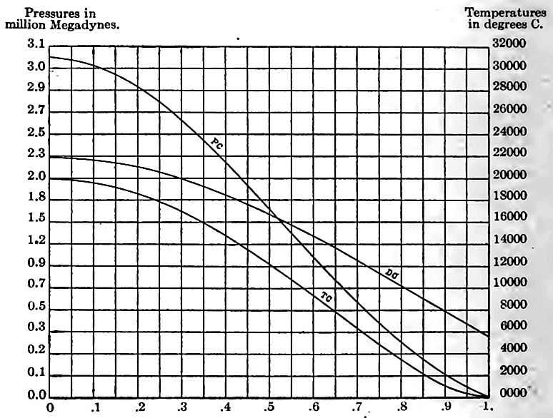
Very different views as to the original state of the matter of the earth are entertained according as the older or the later hypotheses of the origin of the earth are followed. These will be set forth in Chapter XII.[18] In the hypotheses which assign to the young earth a molten state, the original temperature is usually held to have been high, and its distribution somewhat uniform throughout the interior. Cooling afterward affected only a moderate depth, usually computed to be little more than 200 miles. Under the planetesimal hypothesis, which is here favored, the theoretical distribution of the internal heat arising from compression is shown in Fig. 288. The nature of this distribution is such that heat would be conducted from the deep interior to the outer zone 800 to 1,200 miles thick, faster than from the latter onward, with the result of raising the temperature of the outer zone while that of the deep interior falls. The result of this should be a severe crowding of the outer zone upon itself, in shrinking to fit the deep interior as it loses heat and shrinks. This crowding of the thick outer zone upon itself is the assigned cause of the great deformations that gave rise to the abysmal basins and the continental platforms. Very important discoveries have recently been made relative [p. 362] to the effects of radioactivity springing from the spontaneous decomposition of uranium, thorium, and some other substances, on the temperature of the earth. The heat thus generated is even held to be sufficient to account for the heat that is lost from the earth’s surface, and for the rise of temperature below the surface.
[p. 363]
If the effect of radioactivity be superposed on that of compression, it modifies the curve of Fig. 288, by raising its outer part, making it accord with the observed temperatures shown in deep excavations.
Observed temperatures in deep excavations. As the earth is penetrated below the zone of seasonal changes, by wells, mines, tunnels, and other excavations, the temperature is almost invariably found to rise. The rate of rise, however, is far from uniform. If we set aside as exceptional the unusually rapid rise near volcanoes and in other localities of obvious igneous influence, the highest rates are more than six times the lowest, the range being from 1° F. in 20 feet, to 1° in 130 feet, with an average of 1° in 50 to 60 feet. The more recent deep borings in which the temperatures have been carefully recorded indicate a slower rate of rise, say 1° for 80 feet. It is not probable that the average rates of increase as determined by observation continue to the center of the earth. One degree in 60 feet, continued to the earth’s center would give a temperature of 348,000° Fahr., and 1° Fahr. in 100 feet would give 209,000° Fahr. It is much more probable that the rate of rise diminishes below the superficial zone, and that the temperatures cited are far in excess of those actually existing at the center.
The amount of loss of heat. The amount of loss of interior heat may be estimated by that which is observed to be passing outward through the rock, or by computing the amount which should be conveyed outwards with the estimated temperature gradients, and with the known conductivity of rock. On this basis estimates of the loss of heat in 100,000,000 years range from 10° C. (18° Fahr.) (Tait [19]) to 45° C. (81° Fahr.[20]) , for the whole earth. This is an exceedingly small result, and emphasizes the low conductivity of rock.
The amount of shrinkage from loss of heat. With this amount of cooling, the shrinkage from this cause may be calculated, the average coefficient of expansion of rock being known. This has been done, both experimentally and theoretically. For a loss of 10° C. of heat, the circumferential contraction is calculated to be 1.6 to 2.35 miles; for a loss of 45° C, 7.27 to 10.5 miles. These results [p. 364] are so small that unless there is a serious error in the estimated rate of thermal loss, or in the coefficients of expansion, cooling would seem to be a very inadequate cause for the shrinkage implied by mountain folds, overthrust faults, and other crustal deformations. This inadequacy has been strongly urged by various students of the problem.[21] In view of the apparent incompetency of external loss of heat, the possibilities of distortion from other causes deserve consideration.
The transfer of internal heat. Under certain possible conditions, more heat would flow from the central parts of the earth to outer zones than would be passed through them to space, as already stated (Fig. 288) . As a result, the temperature of the central parts might be falling while that of sub-surface zones was rising. A lowering of the average temperature of the inner half of the earth 500° C. and a raising of the temperature of the outer half an equal amount, would cause a lateral thrust of about 83 miles. Some transfer of this kind is among the theoretical possibilities under the planetesimal hypothesis. The process could not continue indefinitely; but computations imply that it may still be in progress.
The rise of lavas. If lavas are forced out from beneath the surface, a compensating sinking of the outer shell will follow. The great lava-flow of the Deccan is credited with an area of 200,000 square miles, and a thickness of 4,000 to 6,000 feet. Vast as this is for a lava-flow, it would form a layer only about 5 feet thick if spread over the whole surface of the globe. The compensatory sinking would cause a lateral thrust, on any great circle, of about 31 feet only. It requires a very generous estimate of the lavas poured out between any two great mountain-making periods since the beginning of well-known geological history, to cause a horizontal thrust of any appreciable part of that involved in the folding of a typical mountain system. The case is different, however, if we go back to the Archean times when the amount of extrusion was very large. Very notable distortion may have arisen from the extravasation of the lavas of that era.
Intrusions of lava rising from lower to higher levels in the [p. 365] earth would have a dynamic effect similar to that of extrusions, so far as the outer portion of the earth is concerned, and the amount of intrusive rock is probably greater than the amount of extrusive; — far greater if the views of vulcanism here entertained are correct.
Rotational possibilities. The oblateness of the present earth is accommodated to its present rate of rotation. It is assumed that such accommodation has always obtained, and that if the rotation has changed, the form of the earth has changed also. The more oblate the spheroid, the larger its surface shell and the less the total force of gravity. If the earth’s rotation has diminished, its crust must have shrunk, because the form of the earth became less spheroidal, and the increase of gravity increased its density. Recent studies imply that the effect of this was probably small.
Sphericity as a factor in deformation. It is obvious that if the earth shrinks, its crust must become too large for the reduced volume, and must be compressed or distorted to fit the shrunken whole. If the radius shortens 5 miles, each great circle must on the average be compressed, wrinkled, or otherwise distorted to the extent of about 31 (5 x 6.28) miles. If the mountain foldings on any great circle, taken together, show a shortening of 100 miles, the corresponding radial shortening is about 16 miles. A segment 3,000 miles across (about 1/8 of a circumference of the earth), such as the bottom of the North Atlantic basin, sinking three miles (about the full depth of the basin), would give a lateral thrust of about 2.3 miles, a little over a mile on each side, a trivial amount compared with the foldings on the adjacent continental borders.
Each portion of the crust of the earth is ideally an arch or dome. When broad areas like continents are considered, it is the dome rather than the arch that is involved, and in this the thrust is ideally toward all parts of its periphery. A dome corresponding to the sphericity of the earth, formed of firm crystalline rock of the high crushing strength of 25,000 pounds to the square inch, and having a weight of 180 pounds to the cubic foot, would, if unsupported below, sustain only 1/525 of its own weight.[22] This result is essentially independent of the extent of the dome, and also of its thickness, provided the former is continental, and the latter does not exceed [p. 366] a small fraction of the earth’s radius. Roughly speaking, each mile of thickness may be conceived to support a layer of about 10 feet of its own material. It is clear therefore, that a dome of shallow depth could not accumulate the stresses involved in the folding of great mountain systems, and that something more than a mere crust of the earth has been involved in the great deformations. But if the great dynamic forces which have deformed the body of the earth have acted through some large part of its depth, and if the rigidity of the interior is as high as the astronomical behavior of the earth implies, its resistance to deformation would be adequate to accumulate such stresses as are required.
The weakness of the crust alone is such that the conclusion seems imperative that, while the pliant subject of minor and frequent warpings, it is wholly incompetent to be the medium of the great deformations. Such deformations apparently involve a large part of the body of the earth, and imply a high state of effective rigidity.
A few references on crustal movements. Lyell, Principles of Geology, Vol. II, p. 235; Reade, Origin of Mountain Ranges, and Evolution of Earth Structure; Fisher, Physics of the Earth’s Crust; Dutton, Greater Problems of Physical Geology, Bull. Phil. Soc. of Washington, Vol. XI, p. 52; also Am. Jour, of Sci., Vol. VIII (1874), p. 121, and Geology of the High Plateaus of Utah (1880); Dana, Manual of Geol., 4th ed., p. 345 et seq.; Woodward, Mathematical Theories of the Earth, Smithsonian Rept. for 1890, p. 196; Willis, The Mechanics of the Appalachian Structures, 13th Ann. Report, U. S. Geol. Surv., Pt. II (1893), pp. 211-282; LeConte, Theories of Mountain Origin, Jour. Geol., Vol. I (1893), p. 542; Gilbert, Jour. Geol., Vol. Ill (1895), p. 333, and Bull. Phil. Soc. of Washington, Vol. XIII (1895), p. 31; Van Hise, Earth Movements, Trans. Wis. Acad. Sci., Arts and Let., Vol. II (1898), pp. 512-514; Estimates and Causes of Crustal Shortening, Jour. Geol., Vol. VI (1898), U. S. Geol. Surv. (1904), pp. 924-931; A. Geikie, Text-book of Geology, 4th ed., pp. 672-702; Chamberlin and Salisbury, Geology, Vol. I, Chapter IX.
Map work. Various phases of diastrophism are shown on the maps of the U. S. Geological Survey listed on pages 432-433 of Salisbury’s Physiography, Advanced Course. Plates CLXV to CLXVII of Professional Paper 60 show certain topographic features due to faults. The folios, especially of mountain regions, afford other illustrations, best seen in the Structure Section Sheets.
¶ Notes
Recent and instructive books on Earthquakes are Dutton’a Earthquake] Hobbs’s Earthquakes; An Introduction to Seismic Geolog;/; Milne’s Earfhr quake* (4th ed.), and the same author’s Seismology, and Knott’s Physics <>/ Earthquake Phenomena. ↩︎
These corrections are due to the decrease in the elasticity, temperature, density, and continuity of the rock as the surface is approached. See the authors’ larger work, Vol. I, p. 528 et seq. ↩︎
The Physics of Earthquake Phenomena, C. G. Knott, 1908, p. 226. ↩︎
Darwin, Journal of Researches, 1845, p. 303. ↩︎
Geikie, Text-book of Geology, 4th ed., p. 372. ↩︎
Koto, Jour. Coll. Sci., Japan, Vol. V, Pt. IV (1893), pp. 329, 339. Cited by Geikie, loc. cit., p. 373. ↩︎
Dutton, Ninth Ann. Rept., U. S. Geol. Surv., pp. 209-528. ↩︎
Oldham, Report on the Indian Earthquake of June 12, 1897, p. 138. Mem. Geol. Surv. of India. Cited by Geikie, loc. cit., p. 374. ↩︎
Oldham, loc. cit., p. 80. ↩︎
Geikie, Text-book of Geology, 4th ed., p. 375. ↩︎
Ibid., p. 376. ↩︎
Forster, Seismology, 1877. Summarized in Am. Geol., Vol. Ill, 1889, p. 182. ↩︎
Heim, Mechanismus der Gebirgsbildung, p. 213. ↩︎
Claypole, Am. Nat., Vol. XIX, p. 257, 1885. ↩︎
McConnel, Geol. Surv. of Canada, p. 33 D, 1886. ↩︎
LeConte, Elements of Geology, 5th ed., p. 266. ↩︎
For distinctions between gravitational energy and gravitational force see the authors’ larger work, Vol. II, pp. 552-553. ↩︎
They may be found more fully stated in the authors’ larger work, Vol. I, pp. 559-574 and Vol. II, pp. 1-81. ↩︎
Tait, Heat, p. 225. ↩︎
Daniell’s Physics, p. 407. ↩︎
Fisher, Physics of the Earth’s Crust, Chap. VIII; and Dutton, Penn. Monthly, Philadelphia, May, 1876. ↩︎
Calculations by Hoskins. ↩︎