| XVIII. Mollusca or Shelled Animals | Title page | XX. Petroleum and Natural Gas, their Distribution and Origin |
[ p. 229 ]
¶ General Characteristics of the Period
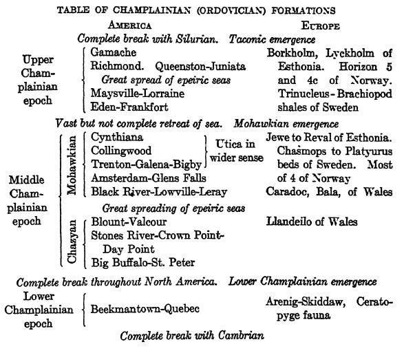
The Champlainian system of rocks lies above the Cambrian and beneath the Silurian, and the name is taken from Lake Champlain (New York-Vermont) where it is well developed. The time of Champlainian endurance was considerably longer than that of any of the six other Paleozoic periods, occupjing in fact about one quarter of this era.
The Three Champlainian Floods. — North America during Champlainian time stood but little above sea-level, and it was only along the margins of the continent that there were uplands. For these reasons it was all the easier for the rising warm-water oceans to spread widely over the land. There were three cycles of floodings and withdrawals, of which the oldest one was of the least extent. The other two floods, mainly of Arctic waters, inundated North America very widely, in fact, more extensively than those of any other time. The second flood took place during the middle part of Middle Champlainian time (Trenton) and was followed by an almost complete withdrawal of these waters. Then early in Upper Champlainian time (middle Richmond) the Arctic waters returned to almost all the places of the earlier inundation.
Champlainian Sediments. — Early or Lower Champlainian time in America was one essentially of dolomite making, while during the middle epoch of this period thin-bedded limestones, along with shale formations, were the dominant kind of rocks laid down. Champlainian time in general may well be spoken of as one essentially of limestone making. During the last of the three epochs, thinbedded limestones were also common, but accompanied by more muds (shales), and toward the close of the epoch came increasing amounts of sediments, with a prevalence of sandstones. These changes from the finest of sediments to coarse ones are evidence of rising lands, quickened erosion, and more rapid transportation of sediments by the rivers. The rising lands are those of Appalachis and especially Acadis, the area of the New England States and the [ p. 230 ] Maritime Provinces of eastern Canada. In western North America, Cascadis was the land from which the sediments in smaller amounts were delivered eastward into the Cordilleric trough.
St. Lawrence Seaways. — In the western portion of the New England States, and in southern Quebec (also New Brunswick), wherever Champlainian strata are known they are usually dark to black shales and greenish sandstones having but little limestone. These formations range in thickness from a few hundred up to more than 2000 feet, and contrast markedly with the dominant limestones and dolomites formed elsewhere during Champlainian time. Another interesting feature is the many thin and thick limestone conglomerates either at the base or in the lower portion of the Champlainian.
The St. Lawrencic sea was also an independent marine province and belonged to the Atlantic realm, since much of its life is common to western Europe. The region was, however, also more or less in connection with the Central Interior sea (see pp. 231, 238).
Interior Seaways. — In the interior of North America the Champlainian seas were, in the main, dear-water ones, depositing largely limestones. Toward the margins of these seas the sediment was greatly increased by the addition of much mud and some sands. In a broad, general way it noay be said that there are in the middle Appalachian region from 6200 to 9700 feet of Champlainian strata, thinning down m the Mississippi valley to, at most, 1900 feet and in many places to less than 1000 feet.
Cordilleran Seaways. — In the Eocky Mountains region the greatest thicknesses are in Nevada and Utah, where there are Champlainian limestones, essentially Lower Champlainian ones, between 3000 and 5000 feet thick. These deposits thin down rapidly northward and also eastward, but in British Columbia they a gain thicken to the northward, for in the Mackenzie valley there appear to be more than 4000 feet of limestones, dolomites, and shales.
Champlainian Life. — With the two greatest marine transgressions came a profusion of life, and of all the floodings none brought a greater diversity of invertebrates than that of the Trenton. Fully 1200 species are known from the Cambrian of North America, but the Champlainian has four times as many. The period was, therefore, one of marvellously great evolutional progress among the lowly organisms. Of the land plants of this time, little has been recovered (Skiddaw of Wales and Maysville of Kentucky), and while fragments of peculiar armored fishes are abundant in Colorado, South Dakota, and Wyoming, they are not found elsewhere. Curioudy, the [ p. 231 ] [ p. 232 ] first appearance of fishes is in river deposits and this is of great significance in their probable evolution, as will be seen in the chapter on the origin of fishes. We may characterize the Champlainian as a continuance of the Cambrian marine invertebrate dominance, but with this difference, that in the younger period all the grander divisions and subdivisions of this type of animals are represented (see Pls. 9, 11, 12). Appearing for the first time in the Champlainian are the true corals, floating graptolites, crinids, bryozoans, and lamellibranchs.
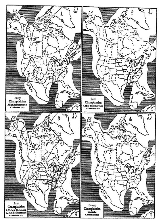
Epeiric seas dotted; oceans ruled. See Plate 10 (p. 238) for Middle Champlainian physiography.
Map 1 illustrates the first flood of this period; Plate 10 the second one; Map 3 shows the third flood, beginning in areas marked 1 and later becoming general; Map 4 brings out the widely emergent condition of North America toward the dose of the Champlainian.
Climate of Champlainian Time. — The vast limestone and dolomite accumulations of Champlainian time throughout North America, which have an abundance and great variety of life even in the Mackenzie valley and arctic Alaska, point to warm and equable waters. The same Middle Champlainian reef corals that are found in Tennessee and New York occur also in BaflSn Land, the Mackenzie River valley, and Alaska, though they are less abundant in the far north. We may therefore assume that the temperature of the lands and the seas in the northern hemisphere was nearly everywhere the same, and that it was warm temperate throughout.
Many years ago Reusch discovered in arctic Norway (Finmarken) a series of tillites whose age could not be definitely determined, but which for general geologic reasons were thought to be of early Cambrian or late Proterozoic time. These tillites have recently been restudied by Holtedahl (1919), who finds that they occur in a sandstone series having a thickness of between 200 and 500 meters. The Bossekop-Mortensnes tillite has a thickness of about 10 meters, the Bigganjarga tillite of 2 to 3 meters. Their age can not even now be definitely fixed, but it is certain that they are either of Champlainian (Ordovician) or Silurian time. They appear to be the tills of local continental glaciers flowing northward.
¶ Divisions of Champlainian Time
History of the Terms Champlainian and Ordovician. — It was Professor Lapworth of Birmingham University, England, who in 1879 proposed the term Ordovician, after the ancient tribe of Ordovices living in Wales at the time of the Roman Empire, to replace Murchison’s Lower Silurian (1835). Further discussion of the term in connection with Cambrian and Silurian will be found in the chapters on those two periods. There is, however, a much older American term, Champlainian, which was proposed in 1842 by the geologists of the New York Survey. This is most appropriate for America, since in the region of Lake Champlain may be studied to good advantage most of the formations now embraced under Ordovician.
Basis for the Divisions. — Partly on the basis of the entombed fossils, but more particularly because of three distinct cycles of continental submergence, Champlainian time in North America is divisible into as many epochs of time, or series of strata. In each [ p. 233 ]
¶ Early or Lower Champlainian Epoch
In no place has there been determined an unbroken deposition from the Cambrian into the Lower Champlainian, and the submergences were restricted to the Acadian area, the eastern and central United States, and the Cordflleran region. Upward of 550 species are known from the Lower Champlainian, though if the strata were not so dominantly dolomitic, causing the destruction of the fossils, the total would probably be at least three times as great.
Life of the St. Lawrence Province. — The fossils of the St. Lawrence province are chiefly graptohtes of the Atlantic realm, since very similar and even identical species recur in Great Lritain, Sweden, and southern Norway. From Cape Breton, Matthew has described another variation of these Atlantic faunas (Ceratopyge fauna), and a similar facies with faunas of the same general type is also known in southeastern Newfoundland, where Van Ingen has described the Lower Champlainian in twenty-six zones.
[ p. 234 ]
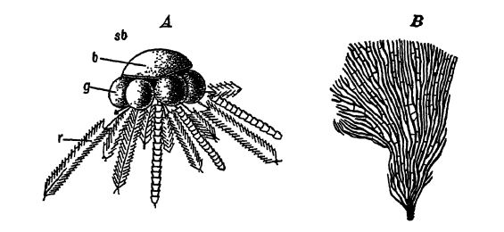
Graptolites (from the Greek words meaiimg written and stones so called because of their resemblance in the fossil state to ancient writings on stone) were colonial animflls with chitinous external skeletons, the part that is preserved. They are related to living hydroids, the simplest of coelenterates. There are two mflin kinds, the dendroids or bush-like forms that are anchored to the sea bottoms (Fig. 5, below) and the free or floating kinds (Fig. A, below, and Figs. 1-6, p, 236). It is the latter that are of most significance in Stratigraphy, since they have widest distribution. Both stocks appeared early in the Champlainian and here the graptolites were most common, decreasing in number in the Silurian. In the Lower Devonian the free forms died out, and the dendroids in the Mississippian.
Quebec Conglomerates. — The thick limestone conglomerates in the Quebec series and at the base of the Champlainian system in Vermont are regarded by Sayles and Coleman as probably of glacial origin. The significance of these conglomerates has been discussed in the Cambrian chapter near its close.
Levis Shales. — The dark shale facies so characteristic of the St. Lawrence province occurs to the south of the St. Lawrence River all the way from near Gaspe, Quebec, to Levis, and thence southeast of Montreal, in Vermont on both sides of the Green Mountains, and in the Taconic Mountains in eastern New York to the south of Albany. These shales have many zones of graptoKtes, the lowest being marked by (1) Dictyonmea flabelliforme, followed upward by (2) Staurograptus, (3) Clonograptus-Tetragraptus, (4) Phyllograptus typus, and zones of Didymograptus (see Pl., p. 236, Figs. 1-6).
The Tetragraptus-Phyllograptus faunas made up of floating forms are worldwide in their distribution. First made known from Canada by James Hall between 1858 and 1865, they have since been reported in many places in the United States, Scandinavia, Wales, Belgium, France, Peru, Bolivia, Australia, and southern New Zealand. Among the graptolites we often see cosmopolitan and widely distributed assemblages, due to their floating habits.
Life of the Appalachian Province. — From northern Lake Champlain south, and more especially from central Pennsylvania into [ p. 235 ] Alabama, there is a series of heavj’-bedded dolomites that have a totally different series of fossils from those of the St. Lawrence province. These strata are also known in much thinned formations in western Tennessee, the Ozark region of Missouri, and in the upjjer Mississippi valley. In most places the dolomites are marked near their base by growths of lime-secreting algse known as Cryptozoon (Fig., p. 198), and at many horizons by peculiar intraformational conglomerates, the pebbles of which are usually of thin, flat pieces, the washed-together broken debris of sun-cracked magnesian limestones. Other than the algse, these dolomites are poor in fossils, due to the alteration from limestones they have imdergone during deposition, though in favored places Mollusca still abound, chiefly thicksheHed gastropods and their curious horn-like and more or less long opercula known as Ceratopea; also a variety of straight, bent, and coiled cephalopods (see Pl., p. 236, Figs. 16-24).
In western Newfoundland there is another representation of this same province in dolomites and magnesian limestones more than 2000 feet thick. Across the Atlantic it is again present at the north end of Scotland in the Durness limestone, and Holtedahl reports it on Bear Island south of Spitsbergen and in extreme northern Norway in Finmarken.
Life of the Cordilleran Province. — The Lower Champlainian is also known to be present in thick formations in the Cordilleric trough, and here the faimal development is again different from that of either the St. Lawrence or the Appalachian area, though dolomites and magnesian limestones are the dominant rock types in both.
Lower Champlainian Emergence. — In all the known areas of North America west of Appalachis and Acadis, there is a marked change in sedimentation between the Lower Champlainian and the succeeding strata of Middle Champlainian time. The older formations are dolomites, while the younger ones are thin-bedded limestones. Furthermore, the Middle Champlainian seas transgressed more widely and their faunas were totally different from those of the earlier epoch. This change is a striking illustration of the fact that the apparently insignificant break — the contact is everywhere a disconformable one — between the Lower and Middle Champlainian is of much time import in that the greatly altered faunas have undergone a long evolutional change. In other words, the break in deposition represents a loss of record long enough for the earlier faunas to have evolved into those so characteristic of Middle Champlainian time. This change is seen best in a completely different series of graptolites; a far greater prevalence of brachiopods, molluscs, and [ p. 236 ] [ p. 237 ] ostracods; the first crinids and fishes; and for the first time an abundance of bryozoans.
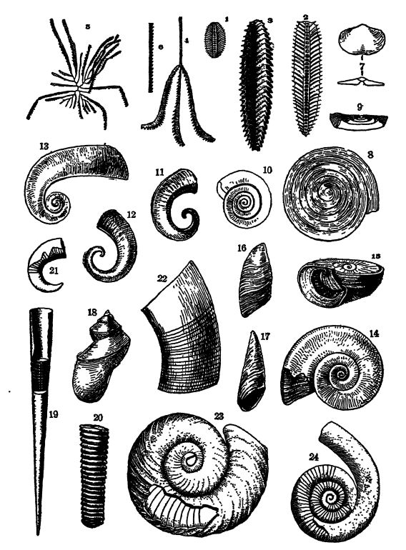
Figs. 1, 2, Phyllograptua Uicifolius and P. angustifolms, crushed flat; 3, P. angustifolius, uncrushed, x 2; 4, Tetragraptus fruticosus; 5, Goniograptus postremus, x i; 6, fragment of Logariograptus logani; 7, Synlropkia lateralis, x 2; 8, Ophlleta complanata; 9, 10, 0. compacta; 11, 12, Eccyliopterus triangrdtbs, x f ; 13, Orihostoma lituifonnis, x i ; 14, Madurites acumincllus; 15, Af. logani of liigher strata, to show the operculum in place; 16, 17, Ceratopea kellhi, the operculum of an unknown Maolurites; 18, Eotomaria (?) cassina, x 19, Orlhoceras mvliicameraium of the Middle Champlainian, x A; 20, Protocydoceras whitfieldi, x I; 21, Cyrtoceras juvenale of the Middle Champlainian, x §; 22, Ooceras leirhyi; 23, Plectoceras (?) oceidentale of the Middle Champlainian, x 24, Sckroederoceras eatorCi, x - In the main after the New York State Survey, R. P. Whitfidd, and H. F. Cleland.
Ozark Dome. — In southern Missouri and northern Arkansas are exposed ancient granites, around which are arranged in crescents and rings the early Paleozoic formations. This arrangement, and particularly the thinning out of many of the formations by overlap against the granites, indicates dome structure, a periodically rising area in the midst of shallow depression fields having epeiric seas. This dome appeared probably toward the close of the Cambrian.
Wisconsin Uplift. — In northern Wisconsin is exposed an ancient mass of rocks, a southern prolongation of the Canadian Shield or Laurentis. Around this p en in sula -like mass in the east, south, and west are arranged in an irregularly parallel way the early Paleozoic formations. This headland came into existence seemingly with the lullamey mountains toward the close of the Proterozoic.
¶ Middle Champlainian Epoch
Seas. — The Middle Champlainian was a long epoch and one with much change between land and sea. The seas were oscillatory and variable, with a final great inundation from the Arctic, the first of a series of Paleozoic floods from this ocean. The maximum submergence occurred early in Trenton time, when the Arctic flood had its greatest extent and seemingly covered about one half of the continent. More of North America was then beneath the sea than at any other time since the beginning of the Paleozoic. Our knowledge of the Cordilleric sea of this time is not extensive, but there appears to have been a through waterway from the Great Basin country into the Arctic Ocean. Encroachments by the Atlantic Ocean were restricted to the northeast of the continent and this ocean sent but little of its life into the Central Interior sea. Finally, nearly aE of the marine water was withdrawn, completing the ebb and flow of Middle Champlainian time. (See Pl., p. 231.)
Life. — During no one of the Paleozoic inundations did the life of the sea record itself so completely by its fossils in the sediments as during the Middle Champlainian epoch. The waters swarmed with a vast variety of iQvertehrate animals, and there are known from North America alone more than 2600 species, chiefly of bryozoans (exceedingly small animals, remotely resembling corals), brachiopods, gastropods, cephalopods, andtrilobites (see Figs., pp. 240, 242). There are about 500 kinds of brachiopods from these deposits in North America, and when the bryozoans are all described there will be more than 1000 species of them. The contribution of the latter as limestone makers, notwithstanding their minute size, Ulrich believes to have been twice as great as that of the brachiopods. There appear to have been as many kinds of gastropods as of brachiopods.
[ p. 238 ]
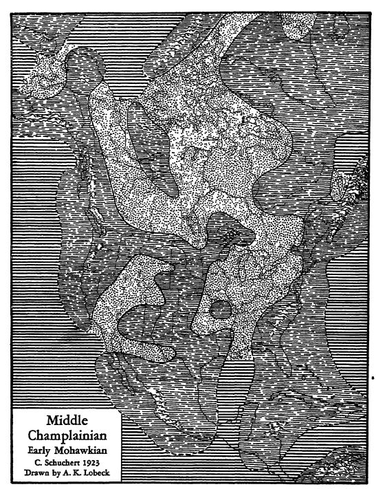
Epeiric seas dotted; oceans ruled; lands in wavy lines. See Plate 8 (p. 231) for Champlainian paleogeography.
The probable geography of Middle Champlainian time, when the lands were widely peneplained and the seas depositing limestone in the main. The seas are described on page 237. The drainage is unknown.
On the lands there may have been some vegetation, and the climate was warm and moist.
[ p. 239 ]
Trilobites are often eonunon and well preserved and include more than 300 kinds, but in general thej- are neither large nor ornate (see Pl., p. 242). The sponges are conspicuous by their rarity, Crinids (animals related to the star-fishes but fastened to the ground by a stalk, see Pl., p. 240, Fig. 5) are locally common, and contributed largely to the making of limestones. The first true Paleozoic corals appeared here, both cup (Pl, p. 240, Figs. 3, 4) and compound forms, along with stony hydroids (stromatoporids) and exhibited a tendency to form reefs.
First Vertebrates. — In 1891 Walcott announced the finding of an abundance of fragmentarj’ vertebrate remains in the rhaToplainian near Canyon City, Colorado, and since then similar r emains have been found in the Big Horn Mountains of Wyoming and the Black Hllls of South Dakota. These fossils usually occur in a sandstone 6 to 8 feet thick at the base of the Middle Champlainian deposits of the Cordllleric sea. There can be no question that these are the armor bones of fishes of the same type seen often in late Silurian and throughout Devonian time (Ostracoderms). They are described in Chapter XXIII. From their fragmental nature and their occurrence in sandstones it seems probable that these fishes were inhabitants of fresh waters, and that after death they were drifted by the rivers and broken up before arriving in the marine sediments of the littoral.
Nelson’s Volcano. — At about the time when the Arctic waters were spreading most widely across North America, there stood a volcano somewhere in eastern Kentucky (between Fayette and Elliot counties). In 1921, W. A. Nelson directed attention to an ash bed in the Lowville formation covering an area of about 360,000 square miles in the Southern States, and of a thickness ranging up to 7 feet. He estimates that the amount of ash blown out equals 66 cubic miles. Until this ash bed (a bentonite or decomposed rhyolitic ash) was discovered, no one had suspected the presence of a volcano anywhere in eastern North America in Champlainian time.
Mohawkian Emergence. — After the great flood in early Trenton time, the waters began to retreat into the oceanic basins, first from the medial portions of the continent and finally from the northern ones. Some water appears to have remained in the southern portion of the Central Interior sea, completing here the marine record between Middle and Upper Champlainian times. It is this vast retreat of the Middle Champlainian epeiric seas and the succeeding long and more or less emergent time of the early Upper Champlainian that bring about a natural separation of these formations into two series of strata (see Pl, p. 231)
[ p. 240 ]
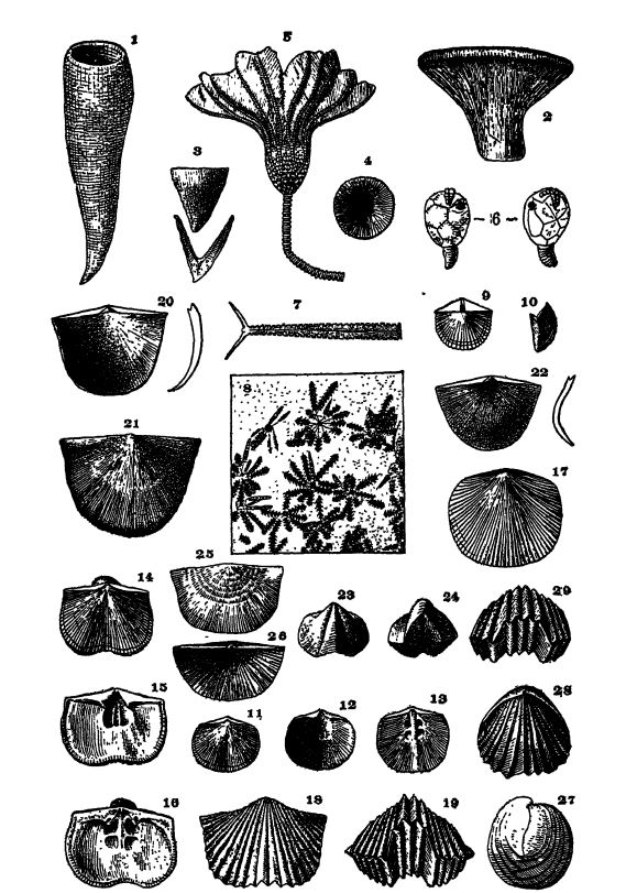
Fig. 1, Cyathospongia reticulata, x i; 2, Zittelella typicalis, x 3, 4, Streptelasma profuridum, x o, Glyptocrinus dyeri, x 6, Lepadocrinus moorei; 7, Climacograptus bicomis; 8, Diplograptus ruedemanni, X f; 9, 10, Orthis tricenaria, x f; 11-13, Dcdmanella testudinaria; 14-16, Hebertella einuata, x 17, Dinorthis subquadrata, x i; 18, 19, Platystrophia laticosia, x 1; 20, 21, Rafinesguina alternata, x i; 22, Strophomma planumbona, x 23, 24, Triplecia extans, x 25, Leptcena rhomboidalis, x f; Plectamhonites sericeus; 27-29, Rhynchotrema capax, X i.
In the main from the New York, Ohio, and Indiana State Surveys.
[ p. 241 ]
¶ Upper Champlainian Epoch
Seas. — The formations of this epoch were first studied in southwestern Ohio and chiefly about Cincinnati, and to the rocks in this region the name Cincinnatian was applied by Meek and Worthen in 1865. The Middle Champlainian sea had almost completely vanished from the continent when a new cycle of water movement spread from the Giilf of Mexico northeastward along the western side of Appalachis, northward into the Ottawa basin, and westward into Indiana. This was the sea of Eden and Maj’sville time (see Pl., p. 231, Map 2), a muddier water than that of the two earlier invasions, and it brought back to the interior sea the previous southern faunas that had been changing elsewhere during the emergent interval into other forms. After nearly 500 feet of shales and thin-bedded limestones had been deposited, another flood from the Arctic Ocean arrived, spread its Richmond fauna far and wide over North America and submerged more than 40 per cent of the continent (see Pl., p. 231, Map 3).
Queenston Delta. — WMle this flood was at its greatest, there formed in the medial Appalachic trough a very large river delta of red sandstones (Juniata), extending from Maryland north into New York, where the brick-red sandy muds may be seen at Niagara Falls (Queenston).
Life. — The Upper Champlainian faimas were at first very similar to those of the previous epoch, but the subsequent Atlantic and Arctic invasions introduced new types of animals which gradually changed into others prophetic of Silurian time. These differences are seen more especially among the bryozoans, brachiopods, and reef-building corals. However, there is still so marked a Middle Champlainian stage of organic development present in the faunas of the Upper Champlainian series as to compel its closer association with the Champlainian than with the Silurian.
Cincinati Axis. — The Cincinnati axis or geanticline is a broad g.ud depressed arch in the Paleozoic strata of the eastern part of the Interior Lowlands. It is seen at the surface extending from north of Cincinnati south to beyond Nashville (see Fig., p. 141). To the east of the arch is the Ohio basin and to the west of it the Indiana basin. This arch began to form in Middle and Upper Champlainian time, but was not a separating ridge in the Great Interior sea until after early Silurian time. In Middle Silurian time a part of the arch in central Kentucky sank below sea-level and this depression was renewed from time to time and harbored marine waters as late as the Pennsylvanian. On the other hand, the southern and [ p. 242 ] [ p. 243 ] especially the northern end was widely invaded at different times by the Great Interior sea. Finally, the top of the entire arch was completely truncated by aerial erosion, since the Upper Devonian sea spread its black muds across both the Xashville and Cincinnati domes.
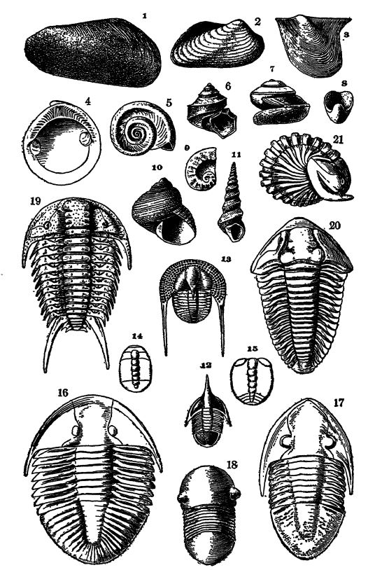
Fig. 1, Modiolopsis modiolaris, x f; 2, Colpomya constricta; 3, Pterinea demissa, X 4 ; 4, CteTiodonta cingulatay x 2 ; 5, Helicotoma planulatoides; 6, Trochonema urnbiLicaiumy x 4; 7, Botomaria supracmgulatay x 4; 8, Protowarthia cancdlata, X 4; 9, Cyrtolltes oTTMtuSy x 4; 10, Cydonema humerosum, x f; lly Hormotoma graciliSf X 4, 12, Ampyx nasutus; 13, Cryptolithits iessdatus; 14, protaspis of Triarthrus beckiy X 20; 15, same of Proetus parviusculusy x 20; 16, Ogygites canadensisy x I; 17, Jaotdus lowensis, x 4; 18, Bumastus trentonensis, X 4; 19, Ceraurus dentcdfis; 20, 21, Ccllymene Tneeki. (242)
¶ Taconic Emergence or Disturbance
Evidence. — From a study of the paleogeography of Middle and Upper Champlainian time, it is seen that the seas were undergoing much change. This unrest in the hydrosphere was apparently due to movements within the bordering masses of the North American continent, not only depressing and elevating the land but affecting the general level of the strand-line as well. We have seen that the greatest mass of sediments was laid dowm along the inner margins of Acadis and Appalachis, and here in the geosjmcline, therefore, occurred the greatest depressions of the original land surfaces. In eastern Pennsylvania this maximum sinking was over 15,000 feet during Cambrian and Champlainian time, and it was about the same, or even 1500 feet greater, along the eastern side of Lake Champlain. In the Great Basin area of the Cordilleric sea the sinking of the bottom during the Early Paleozoic was also great, being over 16,000 feet.
Metamorphism. — In Vermont, and throughout the Taconic Mountains, the Cambrian and Champlainian sandstones are now quartzites, the shales are slates, and the limestones are marbles. This regional metamorphism took place largely if not wholly when the strata were folded and thrusted to the west during the Appalachian Revolution (p. 426) and net, as has been thought, at the close of the Cambrian or the Champlainian. Some of the metamorphism, however, may have been connected with the Acadian disturbance of late Devonian time (see p. 316), along with the injection of igneous rocks now seen to best advantage in the White Mountains of New Hampshire.
It is clear that there was a wide-spread elevation of the New England-Acadian area (= New Brunswick geanticline), beginning before Richmond time, and seemingly renewed at the close of the Champlainian. This elevation is known to have been of a folding or orogenic nature only over a small western part of the area mentioned, and to have renewed erosion in a marked manner. The deposits of this wear and tear of the land are seen in the widespread, red and thick delta deposits of the Upper Champlainian series (Juniata and Queenston formations), and in the thicker and more extended ones of the succeeding Silurian (Medina). Together these coarse deposits made up the Queenston delta.
[ p. 244 ]
The relief of internal stresses is known to have folded the pre-Silurian strata from at least Port Jervis, New York (see Fig., p. 263), northeastward to Kingston and Hudson (Becraft Mountain). Curiousty, however, the often recited evidence for folding at this time, said to have been general throughout the New England States and the Maritime Provinces of Canada, fails to be borne out by the more recent geologic work in these areas. This work does not, however, demonstrate that there was no Taconic folding or mountain making. H. D. Rogers in 1837 was the first to note the significance of the marked angular unconformity at Kingston and described it at length in his famous Geology of Pennsylvania, published in 1859. Considering this evidence and the apparently similar unconformity at Gaspe, Quebec, Dana was led in 1874 to postulate a general upheaval and the making of mountains throughout the area mentioned above. More recently J. M. Clarke has restudied the geology of Gasp6 and concludes that the unconformity is due to overthrusting. Therefore all of the confirmed evidence of mountain making is restricted to a narrow and not long area in the state of New York. For the present, then, the Taconic disturbance must rest upon what is known, but the chances are good that a wider field of orogeny will be proved along the western side of the New Brunswick geanticline. The whole evidence for the Taconic disturbance as recorded in the literature has recently been reviewed at length by T. H. Clark (1921).
Orogeny in Europe. — In Great Britain there was important mountain making toward the close of the Ordovician. It was most marked in western England, Wales, and Ireland, where the Silurian rests unconfonnably upon the older metamorphosed strata. Then, too, in Great Britain, all through Middle and Upper Ordovician time, ashes and lavas, along with intruded deep-seated plutonic rocks, were added to the coarse marine sediments. Jukes-Browne holds that this orogenic movement extended, but with less intensity, far into northern Norway.
The only other extensive mountain ranges known to the writer to have been made in Ordovician times are those of eastern Australia, and this folding was accompanied by much volcanic activity.
¶ Economic Products op the Champlainian
Trenton Oil and Gas. — Between 1886 and 1900, Ohio and Indiana were yielding vast quantities of petroleum and natural gas. To-day the yield in these states is small. It came from the upper 20 to 30 feet of the Trenton dolomite, in places where it is highly crystalline, and at depths of from 1100 to 2200 feet below ground (Kg., p. 257). The Middle Champlainian strata of Illinois are now yielding petroleum in commercial quantities.
The Trenton oil and gas fields are connected in the main with the terrace structure ” of the Cincinnati uplift and are situated under its northern end, and under the short northeasterly trending arch known as the Lima spur of Ohio and the broader northwesterly trending arch known as the Wabash spur of Indiana. The once famous Karg gas well of Kndlay, Ohio, stood on the edge of a rapid descent of the Trenton dolomite; and only a thousand feet west [ p. 245 ] of it, where the top of this formatioii lay 120 feet lower, the adjacent well yielded petroleum.
Slate. — In the Appalachian region, and especially in Pennsylvania and Vermont, Lower Cambrian and Champlainian slate belts are much quarried for black, green and blue, purple and red slates. The uses of roofing and " mill-stock ” slate are now very varied, and the annual production is valued at over $4,000,000. Nothing is more astonishing to see than the vast waste piles of a slate quarry, the worthless material including from 60 to 80 per cent of the rock quarried.
Limestone, Marble, and Cement. — Because of the wide surficial distribution of the Champlainian limestones, they are much quarried for foundation structures, road metal, flux for the reduction of iron ores, and especially for the lime used in mortar, whitewash, and fertilizer for farm land. The annual value of this raw material now ranges around $55,000,000; manufactured, the value is ever so much greater. In the Appalachian valley of Virginia and Pennsylvania they are also much used in the making of Portland cement. In Vermont there are immense quarries in the Middle Champlainian from which is obtained most of the American Carrara, or white and clouded marble. In eastern Tennessee some of the Middle Champlainian fossiliferous limestone if mottled pinkish to deep red in color and is used for decorative and interior building. The annual value of these marbles is now about $5,000,000.
Lead and zinc, mainly in the form of sulphides and carbonates, have been mined for more than a century and in considerable quantity from the Middle Champlainian dolomites of eastern Iowa, southern Wisconsin, and northern Illinois; the formation from which they come is known to geologists as the Galena formation, and is of the same age as the Trenton of New York. The ores occur in solution cavities, in crevices, or as replacements of the limestone and they were leached out of the higher strata by the aerial waters percolating through them, and then segregated at lower levels in the places now found. They were redeposited, however, long after Champlainian time. Some lead is also yielded by the Upper Cambrian of the Ozark region of Missouri and Arkansas.
Iron Ore. — In southeastern Newfoundland there are rich oSlitic iron-ores of early Champlainian time, occurring in five zones.
Calcium phosphate, valuable as a fertilizer, is obtained in central Tennessee, where the Middle Champlainian limestones are rich in tinv eastropods (Cydora) having phosphate of lime shells.
[ p. 246 ]
¶ Collateral Reading
R. S. Bassler, Cambrian and Ordovician. Maryland Geological Survey, 1919.
E. R. Cumings, The Stratigraphy and Paleontology of the Cincinnati Series of Indiana. 32d Annual Report, Indiana Department of Geology and Natural Resources, 1907, pp. 607-1188.
R. Ruedemann, Graptolites of New York. New York State Museum, Memoirs 7 and 11, 1904, 1908.
| XVIII. Mollusca or Shelled Animals | Title page | XX. Petroleum and Natural Gas, their Distribution and Origin |