| XX. Petroleum and Natural Gas, their Distribution and Origin | Title page | XXII. Corals and Coral-like Animals |
[ p. 261 ]
The Term Silurian. — The term Silurian was proposed in 1835 by the great English geologist, Sir Roderick Impey Murchison, who was for a long time the director of the Geological Survey of Great Britain. The area where these rocks were first studied is the border land between England and Wales, the home of the ancient Silures, a Celtic race who fought Caesar’s legions.

History of the Term Silurian. — Previous to 1835 the geological column had been determined down to the Old Red sandstone, the continental phase of the Devonian, the equivalent marine phase having not yet become known. Below lay a great complex then known as the Primitive Series.” On the border land between England and Wales, the “ primitive ” rocks were least disturbed and many of them abounded in fossils. Early in his studies Murchison found that the highly fossiliferous portion represented a system not known before to Geology. At the same time he urged his colleague, Sedgwick, to give the name Cambrian to the greater mass of the greywackes that both men then thought to be older than any part of the Silurian. This was done late in 1835. Even if the proper sequence of the formations was then Yeiy inadequately understood, what was made known marked an epoch in Historical Geology In 1838 Murchison published his “ big book,” The Silurian System, a classic of 800 pages, while Sedgwick delayed until 1855 the printing of his great work, Synopsis of the Classification of the British Rocks.
Murchison subdivided his “ Silurian System ” into an upper and a lower portion, but his Lower Silurian formations were essentially of the same age as the series in the north of Wales that Sedgwick was calling Upper Cambrian. Nor did Murchison see that an angular unconformity separates the Lower from the [ p. 262 ] Upper Silurian, and it was Sedgwick who first showed such a relationship. These differences inevitably led to a controversy which was not adjusted until 1874, when Lapworth restricted the term Silurian to Murchison’s Upper Silurian sequence, leaving Cambrian to be applied, as usage had brought about, to Sedgwick’s Lower Cambrian, and proposing for Sedgwick’s Upper Cambrian and Murchison’s Lower Silurian the term Ordovician.
The upper boundary of the original Silurian also long remained undefinable because of the absence of marine fossils, and because of the erroneous opinion that here there was a transition series passing unbroken into the fresh-water Old Red sandstone. The adjustment was first made in Germany by Kayser (Harz region), in France by Barrois and Pruvost in 1919, and in Shropshire and southern Wales by Stamp in 1920. The result is that all of the “ passage beds ” (Temeside shales at the top, followed beneath by the Downton Castle sandstone = Tilestones, and the Ludlow bone bed) are now referred to the base of the Lower Devonian. The Silurian of the type area, therefore, now ends with the Chonetes flags of the Upper Ludlow. On the basis of these determinations, the upper boundary of the Silurian in America is in this book regarded as beneath the Manlius formation.
General Characteristics of the Period. — The Silurian system of strata lies upon the Champlainian and beneath the Devonian. Silurian time is far shorter than Champlainian. Almost everywhere in North America the strata of the Silurian system are easily separated from the Champlainian below by a more or less long “ break ” or interval. An angular unconformity occurs between them from Port Jervis (see Fig., p. 263), northeast to Kingston and Becraft, New York, but in the New England States and the Maritime Provinces of eastern Canada the reported angular nature of the break has not as yet been established. In the great interior region of the continent the separation, as a rule, can be made only on the basis of the entombed fossils (see Fig. 82, p. 265) . On Anticosti Island in the Gulf of St. Lawrence may be studied the most complete American section. Even here, however, the two periods are separated by a break.
North America during the Silurian had about the same general topographic expression as in Champlainian time, that is, the greater interior basin region stood but little above sea-level, while the highlands, as heretofore, were toward the margins of the continent. Twice was the interior low area transgressed by great floods, first during the Alexandrian epoch and later during the Niagaran epoch, when from 35 to 40 per cent of the continent was imder water. These floods came m the main from the Arctic, spreading south into the United States, while smaller seaways spread from the Gulf of Mexico northward. There were also small seaways in the St. Lawrencic and Acadic geosynclines that were flooded by the Atlantic [ p. 263 ] Ocean. At different times the St. Lawrencic marine waters connected with those of the Appalachic trough. Of the Cordilleric seas little is known.
The life of the Silurian, while prolific, is not so varied as that of the Champlainian. The Silurian strata abound in invertebrate marine animals, but now more land plants are present and land animals (scorpions and thousand-legs) make their first appearance, with a considerable variety of fresh-water fishes. From this time onward, we shall see wider and wider home-making on the lands bj- the emerging life of the waters. The climate was in the main warm, moist, and equable, but in the last Silurian epoch (Cayugan) it became arid over very wide regions; furthermore, the seaway’s during this epoch were small. In consequence, the almost land-locked parts of the epeiric seas deposited during Cayugan time in eastern North America much gypsum and salt. The last of the Silurian seas were very sT uall shifting ones in the Appalachic geosyncline and elsewhere, and they appear to have continued uninterruptedly into Lower Devonian time.
[ p. 264 ]
Toward the close of the Silurian all of western Europe was in the throes of a most marked time of mountain making, giving rise to the Caledonian and other chains of grand mountains. These movements also naturally affected the climate, and there is evidence of glaciers and winters in northern North America.
Cincinnati Uplift. — This low arch, described in Chapter XIX, was not a marked topographic feature in the seas xmtil after Lower Silurian time (see pp. 241, 273), when distinct marine basins lay on either side of it. Floods from the Gulf of Mexico extended northward and covered the areas to the east and west of the arch, but along the western side the waters were most persistent during the Niagaran epoch.
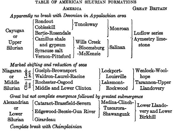
TABLE OF AMERICAN SILURIAN FORMATIONS
¶ Character and Thickness of Silurian Rocks
Eastern United States. — In the Appalachic trough the sedimentaries are coarse-grained throughout until near the close of the Silurian, when much compact or dense cement rock (water limestone) was deposited in very shallow seas, as is indicated by its decidedly sun-cracked nature. These coarse-grained rocks are the results of rapid erosion from the high lands of Appalachis and Acadis following the emergence of late Champlainian time. In east-central Pennsylvania the thickest accumulations occur, with a maximum of 6490 feet. Of this mass the lower 4490 feet are almost devoid of limestones, [ p. 265 ] [ p. 266 ] the strata being cross-bedded sandstones, sandy shales, shales with a little sandy limestone, and, toward the top of the series, local beds of valuable fossil iron-ore. The upper 2000 feet of Upper Silurian age consist of shales gradually becoming more and more calcareous toward the top, which, in New York, Ohio, and western Ontario, bear valuable deposits of rock salt and gypsum.
This great mass of Silurian material thins rapidly to the south and north and probably also to the west under the coal fields of the Allegheny region. In the Niagara Falls area of New York there are about 180 feet of shale, sandstone, and dolomite that thicken rapidly to the south under the cover of the younger strata (see Fig. 84, p. 268). At the Virginia-Tennessee line there are not more than 400 feet of basal sandstone (Clinch) followed by 325 feet of shales and sandstones (Dyestone). South of Tennessee these beds again thicken, there being in the Appalachic trough of northwestern Georgia 1600 feet of Lower and Middle Silurian strata which thin rapidly to the west end of the state, where 180 feet are present.
Acadis. — In the Aeadic trough the Silurian is widely spread and often rich in fossils. A thick section is exposed at Arisaig, Nova Scotia, where there are nearly 4000 feet of shales and sandy limestones. In southeastern Maine the Silurian is locally very thick, there being in the Eastport region about 10,000 feet of volcanic tufis and detrital land sediments. This thickness, however, does not include the volcanics and lava flows, which also have considerable depths.
Another fine exposure of Silurian strata is that of Anticosti Island. It is, however, in the St. Lawrencic trough, with more than 1200 feet of limestones and some shales representing the earliest portion of the American Silurian; the higher beds continuing the section are present farther southwest along the north shore of the Bay of Chaleur, Quebec. At Black Cape the Silurian is about 7000 feet thick and is terminated by lava flows.
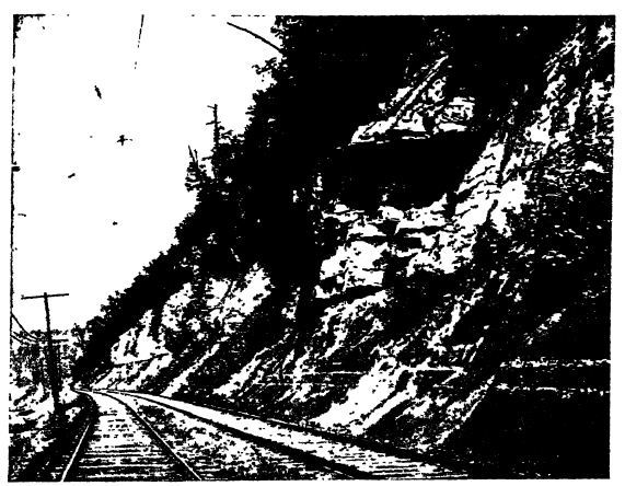
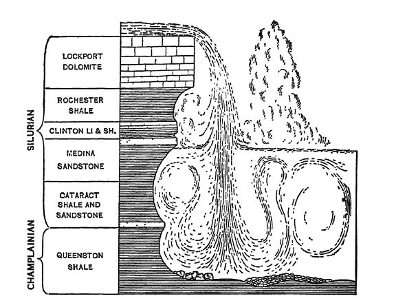
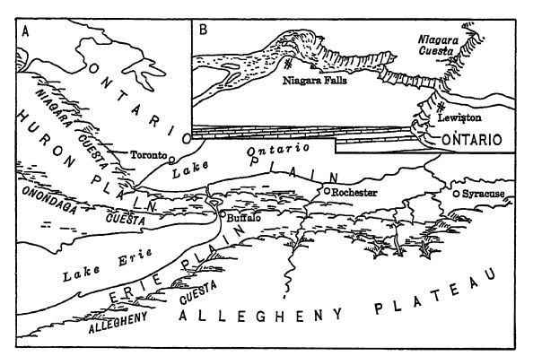
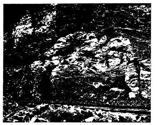
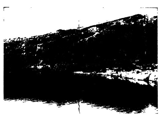
Silurian Sequence at Niagara Falls. — Between Buffalo, New York, and the region about Niagara Falls may be studied a typical Silurian section and one of the iSnest exposures in America for strata of this time. The gorge between the Falls and Lewiston has the lowest strata reposing on the Champlainian, while the younger deposits appear in sequence toward Buffalo, where some of the Middle Devonian is also to be seen in the Bennett quarries. The floor of the “ Cave of the Winds ” beneath the American falls is of Clinton limestone, and the Niagara River dashes over the basal sandstone at the Whirlpool Rapids. The diagram, page 268, shoves the sequence of the beds and the figure, page 267, pictures them as they appear in the walls of the gorge of Niagara River. All of the strata have a gentle dip southward.
Interior of North America. — Here the Silmian seas had clear waters, and their deposits were almost entirely calcareous. Almost all of them were of Middle Silurian time. The strata were widely [ p. 267 ] distributed in two epeiric seas, one being the smaller southern Central Interior sea and the other the far larger sea of the Arctic region. Nowhere are these deposits thick when compared with those of the Appalachic trough, and, u nlike the latter, they are largely limestones, dolomites, and calcareous shales, with almost no sands. In no place does the thickness exceed 1000 feet and in general it is usually considerably under 500 feet.
Rocky Mountains. — The Silurian of western North America is not yet well known and appears to be poorly developed throughout the United States. In the Cordilleric sea of Canada, however, there was another deep trough for near the International Boundary (Bow Pass) there are 1300 feet of dolomte and quartzites. This trough deepened northward, since in the western Mackenzie valley (Gravel River) there are 2000 feet of dolomites, and in Alaska at the Lower Ramparts of the Porcupine River there are 2500 feet of dolomites with some black shale. In southern Alaska in the region of Kuiu Idand there are 2000 feet of limestone. It is in this region that tillites occur, as described on page 277.

In the southern portion of the Cordilleric sea little is known of the Silurian deposits, but such are seen to occur in Nevada and in the Utah area of the Great Basin, where 200 to 300 feet of magnesian limestones have unmistakable Silurian [ p. 268 ] [ p. 269 ] fossils. In the Franklin Range of western Texas there is another Silurian area of a distinct sea, also apparently of Pacific origin; here there are 1000 feet of Middle Silurian limestones.
¶ Life of the Silurian
Marine Provinces. — On the basis of their entombed faunas the American Silurian deposits are geographically divisible into four provinces. These are (1) Atlantic, (2) Southern, (3) Arctic, and (4) Cordilleran (see p. 273). The best knowm of these, with the longest and least broken record, is the Southern province, embracing the Silurian deposits of the southern portion of the Central Interior sea and the Appalachic trough. The Arctic province, of Lower and Middle Silurian time, includes much of the northern interior part of the continent south almost to the Ohio River, and has decided faxmal connections with the Baltic area of northern Europe, the intercommunication being by way of northern Greenland, and the St. Lawrencic trough. In the Cordilleric sea the Silurian faunas are not well known, but appear to be of Pacific origin.
Marine Invertebrates. — As is usual in marine sediments, practically nothing of the soft seaweeds is preserved, although the Silurian life record is almost entirely that of the shallow sea wherein these plants abound. The invertebrates still dominated the seas, because the fishes were as yet not at all common though appearing more abundantly in the late Silurian rocks of Europe. Upward of 2500 species of invertebrates have been described from the American Silmian, the common ones being mainly corals, crinids, bryozoans, brachiopods, and trilobites (see p. 270). Of nautilids there are fewer than a hundred kinds known in America, although the Silmian in other parts of the world (especially Bohemia) was the time of greatest nautihd development; and since then there has been a steady decrease in number of species. True graptolites were still common in the European seas, but in America they are not often found as fossils.
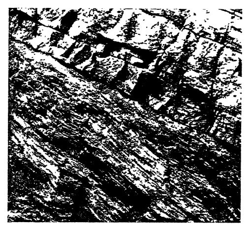
Of crinids there are nearly 400 kinds known in the American Silurian, a far better development than in the Champlainian. The bryozoans were also common, but while they made small reefs in the Clinton, they were not so prolific as in the Champlainian (see Fig. 87, p. 272).
Of brachiopods there are more than 360 kinds described from the Silurian of America (see Pl., p. 270, Figs. 5-14), Although their general development was still much like those of the Champlainian, they were, on the average, larger and more robust. There was also at this time a distinct change in the introduction of many [ p. 270 ] [ p. 271 ] forms that have internal spiralia or calcareous supports for the arms (p. 216) and in the abundance of rhymchonellids and pentamerids.
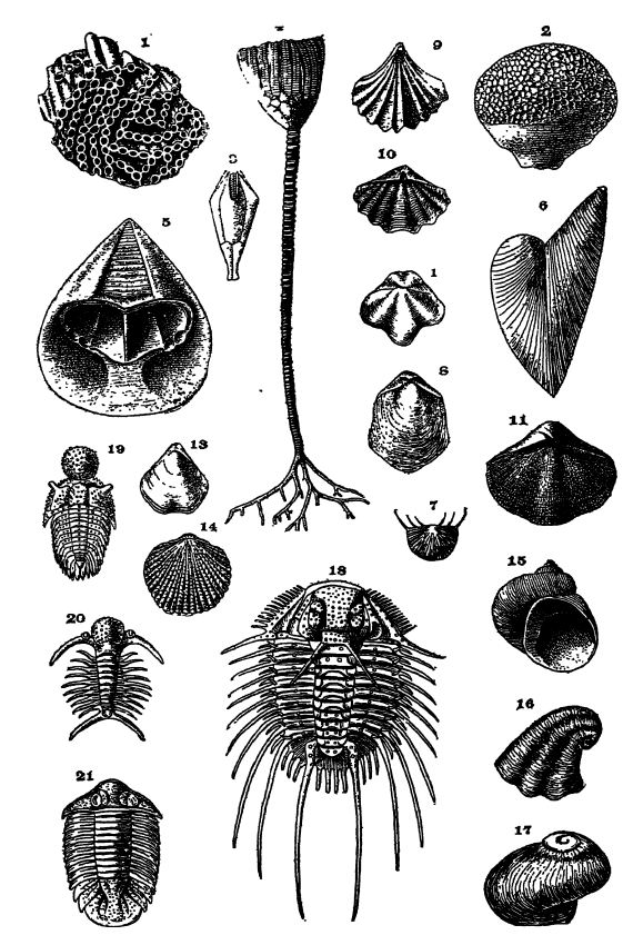
Fig. 1, Halysites catenulatus; 2, Favosites occidentalism X i; 3, Troostocrinus reinwardti; 4, Eucdlyptocrinus crossits, x 5, 6, Monomerellli noveboracum, x i; 7, Chonetes comutus; 8, Pentamerus oblonguS, x 9, Rhynchotreta americana; 10, Spirifer crispus; 11, S. radiatus, x §; 12, Hyattidina congesta; 13, Whitficldella nitidam x 4; 14, Atrypa nodostriata; 15, Strophostylus cycLostomuSm x §; 16, PlatycercLs angulaiuTn; 17, Diaphorostoma niaparense, x 4; 18, Ceralocephala dufrenoyi; 19m StaurocephclltLs murchisoni; 20, Deiphonforbesi; 21, Metopolichas breviceps, x 4. Mainly after tiie New York and Indiana State Surveys. Also from Scott and Zittel.
Of trilobites there were still at least 105 American species, many of which were bizarre looking animals with many spines on the head and tail (see Pl., p. 270, Figs. 18-21). Spinosity is often interpreted as indicating an ebbing of the vital force among the trilobites, but in some forms it may have been a protective device against the carnivorous fishes then coming into being.
Throughout the Silurian, but more particularly in the Upper Silurian, the “ sea scorpions ” or eurypterids were common (see p. 276). They usually occur in brackish-water deposits that otherwise are devoid of fossils, and very similar kinds are found in both eastern America and western Europe. Their immediate ancestors appear to have been marine animals, but after Silurian time they are usually found in fresh-water deposits. The largest American species is found in New York (Pterygotus buffaloensis) , where Clarke and Ruedemann have determined for it a length of nearly 9 feet. The eurypterids are particularly interesting in this connection, not only because they are so characteristic of late Silurian time, but also because they indicate the stock out of which in an earlier period arose the air-breathing or true scorpions.
Coral Reefs. — Corals were not common imtil the Middle Silurian, and then at many places in America they made reef limestones (see Fig. 88, p. 272, and Fig., p. 183 of Pt. I). The best examples of these are seen in Wisconsin, Iowa, and the Manitoulin Islands, and to a more limited extent at Louisville, Kentucky. All of these corals are of the kinds known as Tabulata and Tetracoralla, described in the next chapter.
Associated with the coral reefs, more especially toward the close of the Middle Silurian (Guelph), are seen many thick-shelled animals, most of which are gastropods. Fifty species of these have been described from a limited area in Ontario. Similar associations are seen on the present living reefs, where the molluscs form thick shells, not only because they are necessary- against the crushing power of the active waves, but also because there is much lime in the warm sea-water which can be easily extracted.
Cosmopolitan Character of Middle Silurian Life. — The known marine life of Lower Silurian time is scanty, but that which can be found indicates that each area had its own peculiar assemblage. [ p. 272 ] [ p. 273 ] [ p. 274 ]
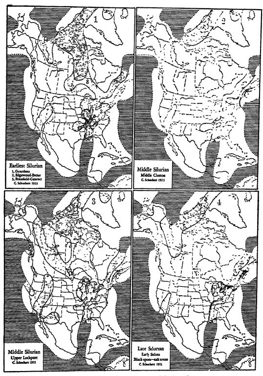
Epeiric seas dotted; oceans ruled.
Map 1 shows three different stages in the flood of Alexandrian time. Maps 2 and 3 show the progression of the second flood, while Map 4 has the lingering seas at the dose of the period, some of which were salt-making basins (the three black spots) during the arid conditions of this late Silurian time.
The same is also true of the earliest Middle Silurian faunas, but it is not so marked as in the earlier time. Finally, when the inundation of the continent was greatest, in Middle Silurian time (p. 273), the faimas of all the provinces took on a more cosmopolitan, appearance and had the greatest number of species in common.
First Land Plants. — The known land plants of Silurian time are as yet exceedingly few, and the specimens are rather indistinct, but our knowledge of them is better than the fragmentary evidence of the Champlainian. Nevertheless, their abundance in the Devonian indicates that there were many land plants living in Silurian times. The discussion of the nature of the first land flora is deferred to a later chapter.

First Land Animals. — Fishes undoubtedly lived in the fresh waters throughout this period, but nothing is known of them until late in Silurian time, when their skeletons are met with in Europe and very rarely in America (the Onchus of Claypole is not from the Clinton but from the Cayugan). As they are so much like those of the Devonian, a description of them is postponed until a later chapter.
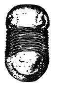
The scorpions of the Silurian are the oldest known air-breathing animals (Fig., above). They probably had their origin in the eurypterids of the sea, seemingly as early as the Champlainian. The largest one known was 2.5 inches long, and in general structure they [ p. 275 ] were very much like the living scorpions, which live entirely on land. The question therefore arises: Were the adult Silurian scorpions wholly adapted to the dry land, or did they live along the seashore between the tides? Their remains are rarely found in marine deposits, but usually in those of brackish water and associated with the eurypterids, which would seem to indicate a littoral habitat. Scorpions are carnivorous animals, and the living forms feed on insects, spiders, and other small forms, killing the prey with their poisonous tail sting. We may assume that the Silurian species lived as do those of the present, and, as the latter are wholly terrestrial, the further question suggests itself. On what could the Silurian forms have fed, since no insects, spiders, or even land snails are known at this time, or for that matter previous to the Carboniferous? As spiders are closely related to scorpions, and as species of the former are known along most sea-coasts, inhabiting the beach between high and low tide, it seems, therefore, a safe inference that the Silurian scorpions also fed and lived, when adult, above the strand-line, though, like frogs, they may have lived in the water during their period of infancy, and that they ate small invertebrates, among them trilobites and small crustaceans.
Other air-breathing animals are the thousand-legs (myriapods) found in the late Silurian strata of Wales in association with eurypterids. Their next known occurrence is in the Old Red sandstone of Scotland.
¶ Silurian Climate
As the Silurian seas abounded in varied life and as the deposits in the main were limestones and dolomites even as far north as the Arctic regions, it is safe to infer that these waters were warm. Additional confirmation is had in the fact that the life of the American Arctic deposits is very much like that of northern Europe and of the United States, while the reef-building corals are practically everywhere the same. The chain coral (HalysiteS, Pl., p. 270, Kg. 1) and the honeycomb coral (Favosites, Fig. 2) are very similar in all the areas, and are found even above 81’" north latitude at Polaris Bay. Further, extensive salt-depositing seas existed in eastern North America between 40° and 45° north latitude, indicating an arid or dry climate on the land, though it is not necessary, because of this evidence, to assume that the temperature was hot. We may therefore conclude, on the basis of the character of the deposits and of the life, that the climate of Silurian time, in the northern hemisphere at least, was temperate to warm.
[ p. 276 ]
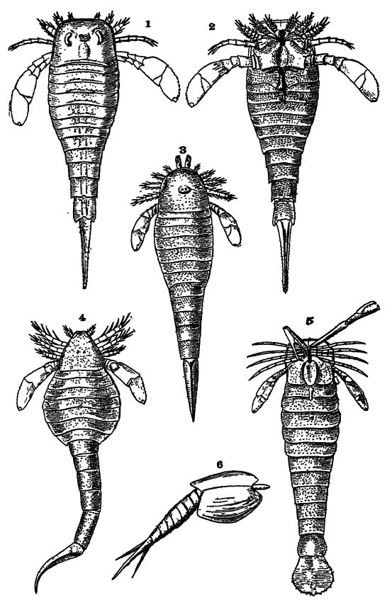
Fig. 1, dorsal aspect of Eurypterus remipes, x 1; 2, same, from the ventral side, female, x ⅓; 3, HiLghmilleria socialise x i; 4, Eitsarcus scorpionis, x i; 5, Pterygotus buffcdoensis, x is; 6, Ceratiocaris. After Clarke and Kuedemann.
[ p. 277 ]
In 1911, in southeastern Alaska in the region of Prince of Wales Island (about 55° to 60° N. Lat.), Kirk noted tillites interbedded with late Niagaran marine strata varjdng in thickness between 1000 and 1500 feet. The material is morainic and the bowlders are abundantly striated. Interglacial warmer climates also appear to be indicated. It may be that the tillites of Finmarken are likewise of this time (see p. 232). F. P. Shepard also described (1922) what appear to be Silurian tillites 200 to 500 feet thick in the mountains of British Columbia.
Oldest Known American Desert. — In the late Silurian of New York and Ontario many of the strata are red beds and associated with them are gypsum and much salt (see p. 279). In Great Britain, red beds are also present in the closing strata of Silurian time. This evidence indicates that desert conditions prevailed here at t.big time, and these climatic conditions were even more prevalent and of far wider extent throughout most of the Devonian.
¶ Caledonian Disturbance of Western Europe
No mountains were made in North America during Silurian time. Active volcanoes of the explosive type, however, were common in southern Maine throughout the Middle Silurian, as indicated by thick Silurian deposits which consist almost wholly of ashes. At the pamp. time other volcanoes throughout a great part of Gasp6 Peninsula were pouring out vast volumes of lava; at Black Cape the lavas are many hundreds of feet thick and are interbedded with late Middle Silurian limestones.
In Great Britain, toward the close of the Silurian, arose the majestic Caledonian ranges, extending from Ireland and Scotland into far northern Spitzbein. This was one of the most important times in the geologic building of the British Isles, and Jukes-Browne states that the Caledonian ranges must have been much grander and loftier than the Alps. The significance of the Caledonian movement is best seen, however, in Norway and Sweden, where the preDevonian strata over an area 1100 miles long have been overturned and pushed horizontally eastward some tens of miles.
In 1910 it was held that the major thrust in the north of Norway was at least 86 miles. Recently, however, Holtedahl (1921) has brought together the newer work and it appears that the overthrusted masses of Cambrian, Ordowcian, and pniirian ages, intruded by granite and gabbro that rose into the sedimentaries while they were in motion, now have, due to pressure from the north, a typical imbricated structure. These orogenic movements, he states, were of long diction. In southern Norway the overthrustings were seemmgly not greater than [ p. 278 ] from 10 to 20 miles, but in the north in the zone of present high mountains they were probably considerably greater. The thickness of the moved mass is at present less than a mile, but originally it must have been much greater. On the other hand, it appears almost certain that the Scandinavian countries have for a long time lain at a low level in respect to that of the sea, and great parts of southern Norway and Sweden were again invaded by it in late Cretaceous time. The present mountainous character of Norway is undoubtedly due to deformation in late Cenozoic time, an elevation that must have been a few thousand feet higher then than now, as proved by the deeply submerged marginal valleys, the beautiful fiords of Norway.
Other ranges trending from northwest to southeast also came into being in France at this time, extending from the Ardennes through the Taunus and Thiiringerwald of Germany into Moravia, beyond which they are hidden by the later overthrustings of the Carpathians.
“ In Asia the margins of the old Irkutsk basin of Siberia were folded into a semicircular mountain chain, while a new geos 3 rncline came into existence in what was formerly a part of the oldland, and in this the succeeding marine strata were deposited ” (Grabau 1921).
New mountains were elevated late in the Silurian in the Sahara desert, for the nearly horizontal Lower Devonian strata rest unconformably upon the folded Silurian beds of the Oran Sahara. Finally, for the second time, much of eastern Australia was folded into mountains. In South America there also must have been much mountain making in late Silurian time, since these strata are absent here, and the following Lower Devonian coarse and muddy marine deposits are in thick formations and of very wide distribution in the Andes and the lowlands to the east.
Close of the Early Paleozoic. — The making of mountains in several continents toward the close of the Silurian, along with the first common appearance in the Devonian of fresh- and saltwater fishes and land floras, is taken as the basis for delimiting the early Paleozoic subera. The early Paleozoic is therefore characterized by the dominance of marine life and the scarcity of living things upon the dry lands and in their fresh waters. The account of the later Paleozoic will bring out the peopling of the lands by the rising land floras and faunas.
¶ Economic Products
Clinton Fossiliferous Iron-ore. — In the Clinton formation of the Appalachic trough from New York to Alabama, there occur in many regions one or more beds, varying from a few inches to 10 and even 40 feet in thickness, of regularly stratified, argillaceous, red iron-ore or hematite (Fe2O3 ). They contain from 30 to 50 per cent of iron and were formerly mined throughout the Appalachian [ p. 279 ] Mountains, but now are worked extensively only in the Birmingham region (Red Mountain) of Alabama. The ore is usually more or less cross-bedded, fossiliferous, and made up of clay, some sand, oolites, and the fragments of invertebrate animals , the calcium carbonate of which is now more or less replaced by ferric oxide; the deposits are, therefore, often called “ red fossil ore.” The beds were evidently made in storm-beaten shallow seas where trituration or breakage of the shells was marked, with a loss of the carbonic acid. Frequently, the grain of the ore is oolitic and cross-bedded or the particles are flattened like flaxseed, and accordingly the ores are also spoken of as oolitic and flaxseed iron ores. In Tennessee, they are known as the Dyestone ores. It is said that over 600,000,000 tons of these oolitic iron-ores are still available under ground.
Silurian Salt in New York. — The Salina deposits (see table, page 264) of central New York, southern Michigan, and Ontario, are one of the very important sources of salt in the United States. The salt is obtained by deep mining of rock salt, or by underground solution, the water being forced down through one driven hole and pumped out of another, and the brine evaporated by artificial heat or that of the sun and air.
[ p. 280 ]
The Salina formation of New York consists mainly of reddish shales with some thin bands of dolomite. Its outcrops extend as a narrow belt across New York State from the Helderberg Mountains westward to Niagara Falls, where the thickness is 380 feet in well borings. From this belt the strata dip southward beneath the younger formations, and 25 miles nearly south of the Batavia outcrops they are 1000 feet beneath the surface, and 1500 feet at a distance of 33 miles. At Syracuse the thickness of the formation is about 600 feet, at Ithaca 1230 feet. Salt springs occur in many parts of New York west of Syracuse and Tully. Rock salt occurs in New York at depths of 800 to 3000 feet or more, over an area measuring 150 miles from east to west, and 60 to 65 miles in width if regarded as extending only to the Pennsylvania boundary. The northern limit of the area is near Morrisville, where 12 feet of salt were found, and near Leroy, 100 miles west of SjTacuse, where a bed 40 feet thick exists. In Livingston and Wyoming coimties the salt beds have an aggregate thickness of 50 to 100 feet, some beds of pure salt being 40 to .80 feet thick. At Ithaca the seven beds of salt have together a thickness of 250 feet and they alternate with shale between depths of 1900 and 3130 feet. For distribution see Map 4, p. 273.
Glass Sand. — In Pennsylvania and Maryland, a white, clean, hard sandstone of angular quartz grains, the basal member of the Alexandrian series (Tuscarora sandstone), is much quarried and crushed for glass sands and abrasives. In northwestern Ohio and southern Michigan the Sylvania quartz sandstone, attaining to a thickness of 150 feet, is even cleaner, and is composed of rounded grain sands, the wind-blown sands of a Silurian desert. This is an ideal material for the making of glass.
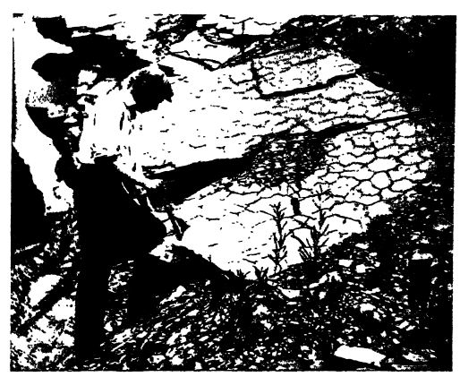
Cement Rock. — The Upper Silurian of the Appalachian area, central and western New York, Ohio, Indiana, Michigan, and Ontario, aboxmds in dark blue, laminated and often wonderfully sun-cracked, impure magnesian limestones, known as water-limes (see Fig., p. 279). These natural cement rocks were at one time widely used for the making of Portland cement, but have now almost everywhere been superseded by pure limestones of Champlainian age, which can be mixed with clay to any desired percentage, according to the quality of cement wanted. See Champlainian chapter, p. 245.
¶ Collateral Reading
J. M. Clarke and Rudolf Ruedemann, The Eurypterida of New York. New York State Museum, Memoir 14, 1922.
J. M. Clarke and Rudolf Ruedemann, Guelph Fauna in the State of New York. Ibid., Memoir 5, 1903.
W. J. Daves, Kentucky Fossil Corals. Kentucky Geological Survey, 1885.
A. W. Grabau, Guide to the Geology and Palaeontology of Niagara Falls and Vicinity. New York State Museum, Bulletin 45, 1901.
James ELall, Description of the Species of Fossils Found in the Niagara Group at Waldron, Indiana. Indiana Department of Geology and Natural Resources, 11th Annual Report, 1882, pp. 217-414.
[ p. 281 ]
E. M. Kindle and F. B. Taylor, Geologic Atlas of the United States, Niagara folio (No. 190). United States Geological Survey, 1913.
R. I. Murchison, The Silurian System. 1839.
Carl Rominger, Fossil Corals, Geological Survey of Michigan, 1876.
Adam Sedgwick, A Synopsis of the Classification of the British Palaeozoic Rocks, 1855.
C. K. Swartz et al., Maryland Geological Survey, Silurian volume, 1923.
| XX. Petroleum and Natural Gas, their Distribution and Origin | Title page | XXII. Corals and Coral-like Animals |