| XXXVIII. The Lower Cretaceous, and the First Appearance of Flowering Plants (Angiosperms) | Title page | XL. The Toothed Birds of Medieval Times |
[ p. 554 ]
The Upper Cretaceous strata were the last to be formed in the Mesozoic era. The way in which the Cretaceous system received its name from the chalk has been dealt with in the chapter on the Lower Cretaceous.
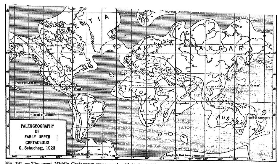
Significant Things About the Upper Cretaceous. — Upper Cretaceous time is known not only for its widely spread chalk deposits but as well for the great flooding of the continents by the oceans. Suess (see Fig., opposite) was the first to point out this flood, probably the greatest of all those of geologic time. In North America was developed the vast Rocky Mountain or Coloradic epeiric sea (see Fig., p. 655).
The next most striking fact is the extraordinary amount of mountain making that took place toward the close of the Cretaceous, since the Rockies then arose in North America and the Andes in South America. As a result of this orogeny, the climate was cooled, but there was no widespread facial one, as might have been expected, although late Cretaceous tillites have been discovered in Australia. The origination of the Gulf of Mexico out of the southern continuation of the Appalachic geos 3 mcline and the definite appearance of Antillis are of this time, and also the formation of the Indian Ocean. With the foundering of parts of the lands bounding the ancestral Indian Ocean, came the mightiest lava floods of all time, to be seen in India, Arabia, and Africa.
[ p. 555 ]
[ p. 556 ]
The Upper Cretaceous was the second marked time of coal making in North America and all of its coal was laid dowm west of the Mississippi valley (see Fig., p. 402).
All through the latter part of the Cretaceous there was a dying out of marine and land animals, and the complete blotting out of the aniinonids, belemnids, dragons, dinosaurs, and birds tvdth teeth. The scaled marine reptiles appeared with the Cretaceous and died out with it. The medieval or Mesozoic era had come to an end.
For the succession of Upper Cretaceous formations see the table on page 537,
¶ Part I. Seas and Strata. The Great Inland Seas of North America
During Upper Cretaceous time a more or less large inland sea was in existence which at first extended from the Arctic Ocean into southern Alexico and from the Cordilleran highlands east almost to the Mississippi River. To the west lay the Central Cordilleran highlands described in the previous chapter and these furnished nearly all the sediments for the seas to the east of them. All of that portion to the north of Texas is known as the Coloradic sea, taking its name not only from the state of Colorado where the Upper Cretaceous formations are well developed, but as well from the older deposits comprehended under the term Colorado series. It is also known as the Rocky Alountain epeiric sea. During this time the sea had its greatest extension, and its deposits continued unbroken into the younger Alontana series, though the seaways were then smaller and finally vanished entirely and for all time. South of New Mexico the Coloradic sea continued widely into the Mexican sea that covered the eastern half of Alexico all the way south to Tehuantepec. Northeastward these waters were continuous with the Gulf of Mexico overlap of the southern United States. Study maps on page 557.
It has been established that the Lower Cretaceous sea appeared first in southern Mexico and that it was an extension of the Gulf of Mexico. In the course of this time the Mexican sea spread farther and farther to the north, finally attaining Kansas and Colorado, while in the far north the Arctic Ocean began to spread southward toward the close of Lower Cretaceous time. Then the southern flood is believed to have begun oscillating back and forth across Kansas and southeastern Colorado. Until recently it was therefore held that there was a long dry-land interval between the Lower and Upper Cretaceous, but Stanton in a recent study of this problem (1922) holds that the muds and sands of Washita time (Cheyenne, [ p. 557 ] Kiowa, Mentor) represent “ merely a halt in that advance rather than a complete retreat of the sea from the Great Plains area as far south as Texas.” Accordingly, as pointed out in the preceding chapter, there is no proper boundarj’ distinguishing the two divisions, i.e., between the Lower Cretaceous (Comanchian) and Upper Cretaceous.
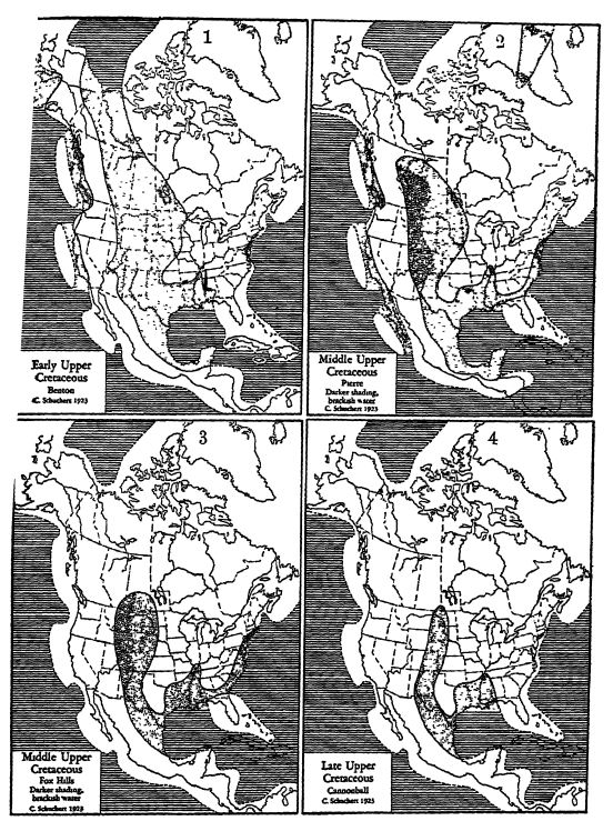
Epeiric and shelf seas dotted; oceans ruled. Fresh-waten deposits in solid tdack. See Plate 43 (p. 569) for latest Cretaceous physiography.
In Map 1 note the vast Coloradic sea, and in the other maps its retreat toward the south. The darker shading in Maps 2 and 3 marks the area of the thick brackishwater deposits which come from the rising Cordilleran Intermontane geanticline. Note also the submergence of Antillis and the continuous land bridge between North and South America.
[ p. 558 ]
Shortly after the Washita, perhaps in middle Dakota time, the Coloradic sea was continuous into the Arctic Ocean and a little later in Benton time had its greatest eastward extension into Iowa, Minnesota, and Manitoba. In the Alexico-Texas portion of the great inland sea, limestones and chalks are the dominant strata, and elsewhere occur muds and sands with coal beds. However, the time of most extensive chalk making was just before the middle of the Upper Cretaceous in the Niobrara, when this kind of rock was laid down from Manitoba south into Texas.
Dakota Formation. — The Dakota sandstone was ori gina lly studied “back of the town of Dakota, Nelnraska ” on the Missouri River about 6 miles south of Sioux City, Iowa. Here the thickness in wells is from 350 to 400 feet, and near the top are found unmistakable Upper Cretaceous brackish-water or marine shells. For a time the whole of this sandstone was believed to form the invading base of the Upper Cretaceous throughout the area of the Great Plains. To the north of the Black Hills there appears to be no typical Dakota sandstone, and southward from Wyoming the basal Cretaceous sandstones and shales also embrace [ p. 559 ] Comanchian fossils. The entire distribution of these sandstones has been HiamisgAH by Stanton (l922) and the flora has been presented in part by Berry (1922).
[ p. 560 ]
Formations of the Great Inland Seas. — The deposits of the Coloradic sea are verj* variable from place to place, and while in the main made up of muds and sands, there are areas of chalk and limestone deposits (Niobrara and Austin formations, 200 to 1500 feet thick). In general, the formations are thickest in the west, where the materials came from the periodically rising Rocky Moimtains, so that brackish and even fresh-water deposits are more frequent here than in the eastern part of the Coloradic sea. For this reason the greater amount of coal (bituminous and lignite) occurs in the western areas of this seaway. While the coal marshes were of greatest extent toward the close of the Cretaceous, some coal was laid down in various places throughout this period, evidence which indicates that the sea was shallow, with many deltas in the western area, along with bars and marshy islands, ever changing from place to place, due to the shifting sea currents, the unloading rivers, and the crustal warpings. Finally, the entire Coloradic basin was silted full, and with the final decided elevation of the Rocky Mountains, this epeiric sea vanished.
In Iowa and Minnesota the Upper Cretaceous deposits are thin, T inging from less than 100 feet to 500 feet, and embracing only the older half of the deposits. Westward the formations thicken rapidly, and the rate of deposition increases with time, so that in South Dakota and northwestern Nebraska the depth of the strata is about 4000 feet. In northern central Wyoming and the Great Plains in general, the thickness is about 10,0(X) feet, and finally in southwestern Wyoming the sections range from 13,000 to over 20,000 feet. These great thicknesses lie in the deepest western part of the basin, and in a genersJ way it can be said that the deposits thin out irregularly both to the north and to the south, though there are notable KEceptions to this, as in southwestern Colorado, where the maximum depth is given as less than 7000 feet. In the Big Horn coal basin of Alberta, the thicknesses are also considerable, being about 6200 feet, and this depth is maintained northward into the Saskatchewan country. Still farther north the depths are greatly reduced.
Toward the close of the Cretaceous (Laramie-Lanee) nearly all of the sea-ways changed from marine to fresh-water conditions, and the sediments were coarse materials (sandstones), often derived from lavas (largely andesites), and ranging in thickness up to 6500 feet. However, at intervals the sea reappeared for a short time through [ p. 561 ] out the area of the Great Plains, depositing beds a few feet in thickness made up almost entirely of oyster shells. These oscillations of the sea and the general vanishing of the marine waters are prophetic of the coming Laramide Revolution.
The faunas of the Coloradic sea were made up almost entirely of moHuses, of which the bivalves (Inoceramus, with a length of 3.5 feet) and gastropods had the greatest specific development, while the ammonids, although greatly reduced in numbers, are still most significant in determining the geologic age of the strata (see Pl., p. 575). Corals, sea-urchins, and braehiopods, so common in Europe, are almost unknoum in deposits of this sea north of Texas. The Coloradic faunas have their own aspect, with the greatest number of species in common with the Mexican sea and the least with the Atlantic overlap.
Formations of the Mexican Sea. — The great inland sea described in the previous pages continued widely into Mexico, where it opened out into the Gulf. The overlap came from the Gulf of Mexico and extended aE the way from central Mexico across the Gulf States northeastward to unite finally with the sheE seas of the Atlantic Ocean. In this spreading we see clearly for the first time the appearance of the Gulf of Mexico, but as a greater gulf thmi it is now.
[ p. 562 ]
In southern Texas on the bordej- jjne of Mexico (Eagle Pass), Upper Cretaceous time is fully represented and there are here about 6550 feet of strata that in the lower portion are made up of clays, marls, chalk, and chalky limestones (the Austm chalks and limestones are 1500 feet thick), while the upper 4000 feet consist largely of sandstones and clays, with valuable coal beds, which recur in the state of Coahuila (see Cretaceous-Eocene contact, Fig., p. 561). The Upper Cretaceous is also well developed throughout northeastern Mexico and as far south as San Luis Potosi in central Mexico, where the Cardenas limestones have an estimated thickness of 1800 feet. South of this region the formations gradually vanish, and none are known in southern Mexico and the greater part of Central America.
Western Gulf Border. — The Gulf of Mexico in Upper Cretaceous times also spread widely over the Gulf States from Texas to Geoigia (see Pl., p. 557) . The overlap appeared earliest in Texas in harmony with the early origin of the Coloradic sea, and did not begin to spread actual marine deposits east of the Mississippi River until the second half of Upper Cretaceous time (Montana) . We have seen that the Upper Cretaceous in southern Texas (Eagle Pass) has a thickness of about 6550 feet, thinning to about 4000 feet in the northeastern part of the state, where the whole of this period is represented by marine beds. Farther east in Arkansas the shore phase of the sj’stem is thin, and only the Upper Cretaceous is present, but in Louisiana beneath the Cenozoic overlap probably all of the strata are present.
Eastern Gulf Border. — The trough of the Mississippi River is occupied by rocks younger than the Mesozoic, and therefore nothing of these strata is seen except in extreme western Tennessee and southern Illinois. Here on the higher eastern land of the trough, Upper Cretaceous formations that are practically unconsolidated are met with from Tennessee through eastern Mississippi into Alabama and Georgia. Nearly everywhere they overlap Paleozoic strata, and in Georgia they rest on the more ancient crystallines (Pl., p. 557). The invasion is variable in time and character of deposits from place to place, beginning as a rule with fresh- to brackish-water sandstones that pass into clays and marls and locally into a thick deposit of impure chalks. The total thickness here is about 2400 feet. The “ rotten limestone ” or Selma chalk formation of Upper Cretaceous age in western Alabama and eastern Mississippi is 1000 feet thick, but east and west of this area the calcareous deposits are replaced by marls, clays, and finally sandstones. The thickness of these [ p. 563 ] eastern Cretaceous deposits does not exceed 1300 feet, and usually ranges nearer 500 feet.
Life of the Gulf Seas. — The younger Cretaceous faunas (Montana) of Texas are more harmonious with those of Mexico than with similar horizons of the Coloradic sea, being probably of waters with a higher temperature. Those of the eastern Gulf border take on more and more of the Atlantic border elements. Almost none of the warmer water rudistids and corals appear east of the Mississippi trough, though foraminifers, sea-urchins, and brachiopods occur here and northeastward, indicating the marine purity of the waters.
¶ Vanishing of the Great Inland Seas
Final Continental Deposits. — We have seen that the marine Upper Cretaceous of the Rocky Mountains region also has intermingled with it a considerable amount of fresh-water formations, and that the latter tend to recur oftener toward the close of the period. Over them often lie other fresh-water deposits usually regarded as of Cenozoic age, and while in general geologists are agreed as to the line of separation between the Cretaceous and Eocene marine deposits, from the time work was begun in this region of the Great Plains investigators have been in doubt as to the division line. In recent years this question of classification has become acute, and though many of the best geologists and paleontologists have labored toward its solution, the problem is not yet satisfactorily adjusted. The field relations of the formations are fairly well known, but how much value shall be ascribed to the unconformable and disconformable contacts between the series of strata, and whether animals or plants shall be the deciding evidence, are still unsettled questions. As the sediments come from the same western source as those of the previous formations, they are consequently very much like the older ones. Again, the fossils are not markedly different in their evolutionary change between the accepted and the debatable Cretaceous formations. There is no lack of fossils in these beds and the difference of opinion among the stratigraphers lies in the fact that the students of invertebrate and vertebrate life find the Cretaceous faunas continued into beds which the paleobotanists hold have floras that are clearly Cenozoic in aspect. Or, briefly put, in the same strata the animals appear to be of Cretaceous kinds while the plants seem to be of the early Eocene.
Cannonball Formation or the Final Marine Cretaceous. — In various states of the Great Plains, evidences of late Cretaceous seas are found, the latest of which is that of the Cannonball member of the Lance formation of North Dakota, with a known extent of 130 miles. Lloyd divides the Lance into a lower member of continental deposits (400 feet), with dinosaurs, and a flora that [ p. 564 ] Knowlton says is indistinguishable from the plants of the Fort Union; and an overlying marine Cannonball member (300 feet), with a fauna of seventy-three species (Stanton 1920). Two are sharks, six are cup corals, two are foraminifers, and the rest are molluscs (thirty-one each of gastropods and bivalves, and one scaphopod). Of these forms but one type (brackish-water) passes upward into the Fort Union, while twenty-four occur below in the marine Fox Hills or older Cretaceous formations. Not one of the species is known in the marine Eocene province of the Gulf of Mexico, and of the latest Cretaceous faunas of the lastnamed province, not one passes into the Mesozoic. All of the Lance dinosaurs are therefore of Mesozoic age.
Paleocene. — In Europe and America, the formations that are debatably Mesozoic or Cenozoic in time have since 1874 been grouped under the term Paleocene, which means oldest Eocene. In the Great Plains of North America the Paleocene deposits are of wide distribution and include the Fort Union, Puerco, and Torrejon beds, with combined thicknesses ranging between 1000 and 2000 feet.
Fort Union, the Last of the Mesozoic. — The great changes in the animal assemblages of the Cenozoic strata, seen in the rapid vanishing of the old forms and the arrival of unheralded migrants from unknown regions, come later than those among the plants. Let us look into this subject to see what is its significance in Stratigraphy. The latest Cretaceous marine faunas vanish, and dependence for stratigraphic correlation is then held to be best among the land animals such as the dinosaurs and archaic mammals. The former in the Lance and the latter in the Lance and Fort Union are still Mesozoic in development, and besides, these formations pass one into the other unbroken, the very significant time break comiag after the Fort Union. That the time is still Mesozoic during the Lance is seen in the retiun of the Coloradic sea, depositing the Cannonball marine strata replete with unmistakable Cretaceous invertebrates, closely allied with those of the earlier Fox Hills formation.
Since stratigraphers are agreed that the Pierre unbroken into the Fox Hills, and that the Lance does likewise into the Fort Union, we should digress a little here to point out that the Fox Hills also is continuous into the Lance, at least in most places in South Dakota. In other places, however, the Fox Hills was channeled to depths of 100 feet and to 600 feet in width. In such places there is an apparent angular unconformity between the Fox Hills and the Lance, imce blocks of the former have slumped toward and into the hollows. Here, therefore, the Lance lies unconformably upon the Fox Hills, but elsewhere there is complete transition between these formations (F. Ward 1924).
After Lance time the climate is changing slowly to a drier condition, the dinosaurs are dying out for want of proper habitat, but the archaic mammals are rising into greater variety and size, [ p. 565 ] and so continue into the Eocene (Wasatch). After Fort Union time (including Puerco and Torrejon) comes the greatest elevation of the Laramide mountains, when the climate, at least locally, becomes alpine (tillites of early Eocene time are present in southwestern Colorado), and with the next higher formation, the Wasatch, come the heralders of modernity in the migrant placental mammals.
The evidence relating to the field relations and stratigraphy, the orogeny and paleogeography, and the invertebrate and vertebrate fossils of the Montana series and the Fox Hills and Lance formations is now well enough in hand to conclude that they all are unmistakably of Mesozoic time. Then, because the Lance and Fort Union are continuous formations; because these, with the Puerco and Torrejon, have wholly archaic mammal faunas and are followed by a period of greater orogeny; and since the succeeding Eocene deposits have wholly different and modernized mammal assemblages, the line separating the Mesozoic from the Cenozoic lies between the Fort Union and the Wasatch, and not between the Fox Hills and the Lance.
What we have been discussing here is the record of the “ interval ” between the Mesozoic and Cenozoic eras, a record that is usually absent at these “ critical times.” Some invertebrate and vertebrate paleontologists, therefore, prefer to hold that the time is still Cretaceous. Usually our classifications in Historical Geology recognize the beginning of a new period by the arrival of strangers, forms prophetic of coming dynasties, laying the stress upon these rather than upon the evidence of the “ hold overs ” from an older time. It is the placental mammals of the Wasatch that indicate Eocene time and the beginning of a new era, the Age of Mammals that is to culminate in man.
The student who wishes to work out this knotty problem for himself should consult the references cited at the end of this chapter.
¶ Atlantic Shelf Sea
Upper Cretaceous formations are known all along the Atlanlie border, either beneath or inland of the Cenozoic marine strata from South Carolina to the south coast of Massachusetts (see Pl., p. 657). They all dip seaward, though their original position is now warped due to elevation in the west. East of New Jersey the outcrops are scattering and mainly of brackish-water origin, while south of Maryland these deposits are seen only in the river valleys beneath the Cenozoic. Therefore the area yielding most information [ p. 566 ] is in New Jersey and Maryland. Here the deposits average between 1000 and 1325 feet, of which the lower 400 to 600 feet are either of fresh-water or brackish-water origin. Here, too, the materials are unconsolidated, and consist in the lower hah of gravels, sands, and clays with lignite, wMe the upper portion is made up of clays and sands becoming more and more glauconitic and finally going over mainly into greensands. Glauconite is characteristic of the Atlantic overlap and at times is also found in considerable quantity in the eastern Gulf border.
Life of the Atlantic Cretaceous. — The marine invertebrate faunas are large, consisting of about 600 forms, in the main Mollusca (Pl., p. 575) . Weller says that many of these have a wide distribution, as many of the New Jersey species also occur in the Gulf border area and mainly east of the Mississippi River. Further, the faunas indicate late Cretaceous time (Montana), and while definite but broad correlations can be made with the formations of the Coloradic sea, there are not many species in common between the two widely separated areas with which this can be done. This marked difference in faunas is thought to be due to colder waters along the North Atlantic shores. The floras occur mainly in the basal formations, where 150 forms have been discovered.
¶ Invasion by the Pacific Ocean
Overlying the Liower Cretaceous (Shastan) strata of the Californic geosyncline disconformably, but usually unconformably, is the Chico series of sandstones and shales, with local conglomerates and coal beds. The coarse deposits and thick formations of the Chico are found in the British Columbic geosyncline all the way from the lower Yukon, the Alaskan peninsula (1000 feet), and the Queen Charlotte Islands (11,000 feet), to Vancouver Island (5000 feet); and in the Calif ornic geosyncline from middle and aouthem Oregon (4000 feet), the Sacramento valley (9500 feet), and the Coast Range of California, to San Diego and the peninsula of Lower California, as far south as 31° 30’ (see Pl., p. 557). In California there were two periods of volcanic activity and in the Queen Charlotte Islands one of long endurance.
These beds begin somewhat earlier in time and continue longer than those of the Colorado series of the great Interior or Coloradic sea, but do not embrace, according to Stanton, the youngest Cretaceous time.
The Chico faunas were essentially molluscan, and, like those of the earlier Shastan (Horsetown), were of the Indo-Pacific province, and were markedly different from those of the Coloradic and Mexican seas. A few species of bivalves were common to the two areas mentioned, but these forms were world wide in their distribution. The evidence, then, is decidedly in favor of the view that the Pacific sea was shut out by a land barrier, the rising Rocky Mountaizis, from entering the Coloradic epeiric sea.
[ p. 567 ]
¶ Part II. Crustal Movements, Climate, and Life
Laramide Mountains. — To the west of the Coloradic sea were the Central Cordilleran highlands discussed in the previous chapter. This arch or geanticline had been rising intermittently during the time of the Upper Cretaceous, while the Coloradic geosyncline or great mland sea was subsiding and receiving the vast detritals originating in the western highlands. When this arch was rising, especially after Pierre time, the geanticline was studded with active volcanoes that extruded much lava. These lavas, eroding, furnished the andesitic débris seen so abundantly in the latest Cretaceous marine and continental formations. These eruptions continued with unabated vigor to the end of Fort Union time, and even into the early Eocene, and the volcanoes extended from Mexico City and Arizona north into Canada.
[ p. 568 ]
These volcanic eruptions were but sjTnptoms of crustal movements, for mountain malring of a folding nature, and thrusting toward the east on a vast scale (see Pt. I, p. 367), were going on during late Cretaceous time: the rising of the Rocky Mountains. The first period of marked erogenic movement, but the lesser of two, came at about Laramie time, and then during a long interval of erogenic inactivity the essentially fresh-water Lance and Fort Union formations were deposited to the east of the rising Laramide mountains. Finally, at the close of the Cretaceous (Fort Union time) and before Wasatch deposition, came the most intense folding, the actual Laramide Revolution of Dana. It was then that the Central Cordilleran highlands were transformed into the very long Rocky Mountains proper and the Colorado Ranges, culminating in many conspicuous peaks such as Pike’s Peak, 14,100 feet, and Long’s Peak, 14,221 feet, and continuing southward into the Sangre de Cristo Range of New Mexico.
The Laramide orogeny was equalled by that of the closing period of the Paleozoic, but was exceeded by the deformation of late Cenozoic time. The area affected embraced the Rocky Mountains from southern Mexico into arctic Alaska.
In Central Japan huge bathyliths of quartz-diorite and granite were intruded into the older rocks towards the close of the Mesozoic. Volcanic activity continued into Cenozoic tune (Kato).
Along the Pacific coast in the areas of the Coast Ranges and the Klamath, Oregon, and Olympic mountains, the movements were small, and here the Cenozoic formations are as a rule not separated from those of the Mesozoic by an angular imconformity.
At the same time the Appalachians were reelevated about 2000 feet (see Figs., pp. 567 and 569), due not to horizontal thrusting but to vertical uplift (see Pt. I, p. 396).
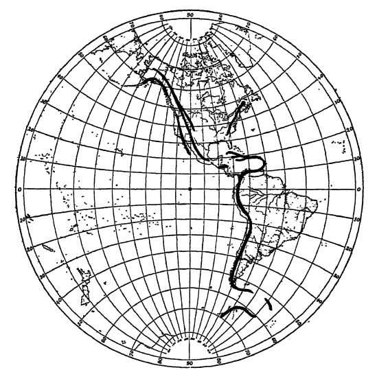
Birth of the Andes. — During the Paleozoic and Mesozoic there existed along the western side of the whole of South America a geosyncline, a subsiding area containing the Andeic inland sea. To the west of it stood a wide and repeatedly rising highland that was furnishing the rock materials for the Andeic sea. To the east of this sea lay a very extensive lowland, the Amazonian Shield, which in its history repeats the plains topography of the Canadian Shield.
In the middle of the Upper Cretaceous, and more especially in latest Mesozoic time, the Andeic geossmcline began to fold and rise into a mountain tract, the longest in the world. Beginning east of Trinidad off Venezuela, these moimtains extend southwestward into Colombia and thence southward all along western South [ p. 569 ] [ p. 570 ] America to beyond Cape Horn, a distance of nearly 5000 miles. In the geology of South America they are what the Rocky Mountains are in that of North America. With the folding of the Andeic geosyncline, the highlands to the west of it began to founder into the depths of the Pacific Ocean. This borderland probably first broke up into island arcs similar to those now off eastern Asia, nearly all of which during the Pliocene and Pleistocene went down into the present great depths of the Pacific Ocean (see Fig., p. 567).
Oceans ruled; lands in wavy lines.
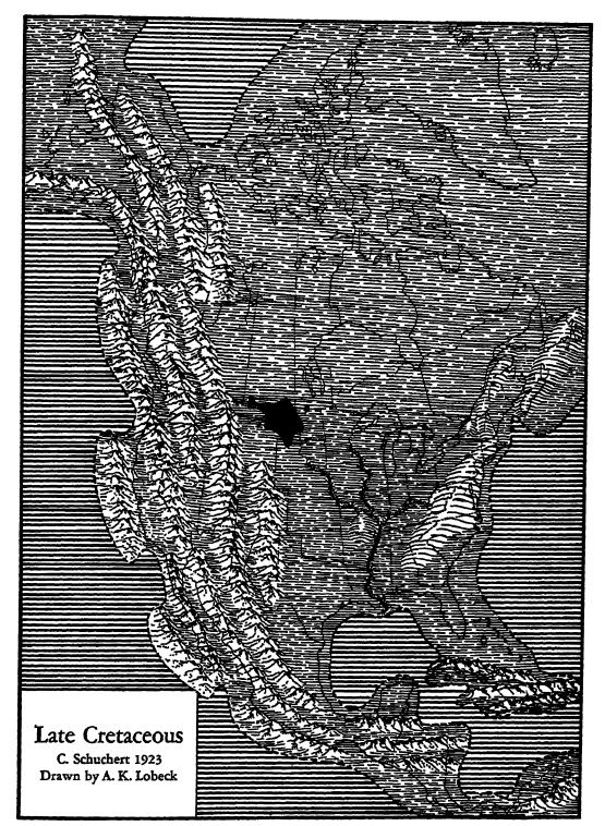
Note that the continent is completely emergent, and that in the west it is newly risen into the Rocky, Cordilleran, and Pacific mountains, while in the east the Appalachian area is again domed (pp. 567-568). Antillis and Central America also are mountainous (p. 570).
The black spot is the area of Fort Union fresh-water deposits (pp. 563-565). The drainage of the Mississippi astern is well established.
The Old Land Antillis. — Upper Cretaceous marine deposits are known in many parts of Cuba, consisting here of magnesian marls and glauconitic limestones. They occur also in San Domingo and Jamaica, where the Blue Mountain series, 5000 feet thick, begins with tuffs and lavas, passing into dark colored shales, marls, and limestones, all resting unconformably upon metamorphosed and igneous formations of older age. These deposits were greatly deformed and intruded by igneous material before the opening of Conozoic time.
The fauna of the Mexican and Antillian seas was of the normal marine type, and of warmer waters. The molluscs abounded here, and the foraminifers, corals, and especially the cemented bivalves (rudistids, Fig., p. 574) flourished.
Geologists have long accepted as a fact the existence of an old land in the region of the greater Antilles, the Bahamas, and southern Florida. The origin of this land is, however, shrouded in deepest mystery and may go back into Proterozoic time, though the known fossiliferous strata begin with the Middle Jurassic of western Cuba. In many places, however, Mesozoic and Cenozoic formations are seen to rest upon a peneplained surface of greatly deformed and much metamorphosed rocks. This old complex is therefore held to be certainly as old as the Permian.
There is evidence of crustal deformation in the greater Antilles, and of the birth of mountains at the close of the Mesozoic, though their presence is much clearer at the end of Eocene time. Then mountains trending east and west extended from eastern Porto Rico and in going westward bifurcated, the southern range passing through the southwestern peninsula of Haiti into Jamaica and westward. The northern range passed westward through northern Haiti and southeastern Cuba into the Cayman Islands. Some geologists think these mountains continued imbroken even into Guatemala and Honduras.
“ A series of fault zones extending along arcs that run approximately east and west have determined the major relief features in the region of the Greater [ p. 571 ] Antilles. Displacements along these fault zones have resulted in the formation of great trough-like valleys. The fault troughs are for the most part submerged beneath the Atlantic Ocean and Caribbean Sea and are, therefore, protected from erosion. They are characterized by great depth, precipitous inclosing scarps, abrupt changes in slope at the top and bottom, and relatively flat floors that, instead of being graded like river valleys, rise and fall throughout their length. The deepest places are close to the foot of the inclosing scarps rather than near the center of the trench, while horsts are also present along the fault zones ” (S. Taber 1921). For further discussion of Antillis, see page 595.
Origin of the Greater Gulf of Mexico. — There was no lower Mississippi basin in the form seen to-day before Lower Cretaceous time because nearly all of the Gulf States since the Pennsylvanian had been more or less of a highland (but not a mountainous folded tract) that trended east and west. During all of this vast time, the drainage of the upper Mississippi River had flowed westward, either through the Arkansas valley or north of the Ozark dome, probably to empty into the GuK of California. Toward the close of Lower Cretaceous time, in what is now the lower Mississippi valley, the land began to subside, and soon this sinking diverted the primal Mississippi River from its western course to its present southern termination. This downwarping is first seen in the state of Mississippi and finally the trough embraced all the area from central Alabama westward into central Texas. From the Gulf of Mexico the depression narrowed northward across these states and eastern Arkansas, western Tennessee and Kentucky into southern nimois. The maximum extent of this basin was attained in the later Upper Cretaceous and early Cenozoic. Since then the general tendency has been uplift in the Gulf border states. During the time of the greater basin there were laid down in an intermittent sequence many formations that in the main are marine and may aggregate 10,000 feet in thickness.
In the northern portion of the Gulf basin the subsidence was mainly of the slightly downwarping kind, with the greater amount of sinking on the Arkansas side. On the flanks of the southern part of the trough, however, there was more or less faulting, and of a striking nature. In eastern Texas near the western margin of the Cenozoic formations there was a downthrow on the eastern and northeastern sides of from 1000 to 1500 feet. This took place in Cenozoic time and is evidenced in the Balcones fault that is clearly of early Cenozoic age (certainly post-Midway). Faulting of about the same time, and with greater throw, took place all along the eastern margin of Mexico, extending into southern Vera Cruz. Parenthetically it should be said that the inbreaking of the GuK began in the south in Cretaceous time and continued at least to the close of the Eocene. On the eastern side of the GuK basin, in northwestern Alabama, there was a downthrow of at least 10,000 feet (Hilgard 1871, and Branner 1897).
[ p. 572 ]
It should be added here that the Gulf of Mexico actually had its inception certainly as far back as Lower Cambrian time, when the Appalachic geosyncline, so far as can be seen from present evidence, continued across what is now Alabama and Mississippi, the deeper part of the Gulf, and southern Mexico (Tabasco, Chiapas, and Guatemala), into the Pacific Ocean. Throughout Paleozoic time this widened Gulf of Mexico portion of the Appalachic geosyncline appears to have been in existence, but beginning with the Upper Triassic the bounding southwestern land (Mexico) began to warp into the depths of the trough. In the Jurassic, and especially beginning with the Lower Cretaceous, not only parts of Mexico, but Antillis and the Gulf border states as well, began to be dragged into the depths, making during late Mesozoic and Cenozoic time the greater Gulf of Mexico. The present great depths of the Gulf of Mexico, and more especially of the Caribbean Sea, however, came into existence during the Cenozoic and seemingly after Miocene time.
Origin of the Indian Ocean, and the Greatest of Lava Flows. — During the Cretaceous and more especially in Upper Cretaceous time came the dowmbreaking of the lands bordering the Indian Ocean, and the development here of the present geography. At the same time, there began the transformation of the eastern end of the greater mediterranean (Tethys) from an area of deposition into one of land rising into the grandest mountains of the present, the Himalayas.
From south of Madagascar north to India, greater Africa, Arabia, and India were breaking down into a far larger Indian Ocean and the beginnings of the Arabian Sea. The first clear evidences of this foundering of the lands bordering the Indian Ocean are seen in the volcanic eruptions of Arabia in early Upper Cretaceous time (Cenomanian), and then later in this period the belching forth of greater and greater amounts of lavas became more general. These are the most colossal eruptions known to geologists. The outpourings began with the “ plateau lavas ” of Abyssinia and southern and northern Arabia (Senonian time) and later (Danian) were far more general in India and in the area of the present Arabian Sea.
Professor Wadia of Kashmir states that the lavas (commonly basalts, rarely rhyolite or trachyte) of peninsular India, emanating through fissures, cover an area to-day of at least 200,000 square miles, but that originally their extent was about two and a half times as great. In the north about Bombay they are nearly 10,000 feet thick, thinning rapidly to the east, and in the south of the peninsula their depth is between 2000 and 2500 feet. The individual flows average 15 feet but single ones are as thick as 50 feet. They are known as the Deccan traps and consist of basalts and trachytes. Since their origin they have been much jointed into a stair-like topography.
Eastern Africa during late Cretaceous time was being tom apart and greatly faulted, and long narrow blocks dropped several thousands of feet, forming the [ p. 573 ] rift valleys so characteristic of Africa and Arabia. The Red Sea and Lakes Nyassa and Tanganyika are examples. The mflYiTmnn of rifting took place in middle Cenozoic time. Along with this fracturing of eastern Africa came marked volcanic activity, and the land was deeply covered with lavas. “ The size of the area buried under volcanic material, the vast bulk of the ejecta, the variety of lavas, and the prolonged duration of the eruptions make East Africa one of the greatest volcanic regions of the world” (J. W. Gregory 1921. Also see E. Erenkel 1922).
¶ Climate of Cretaceous Time
On an earlier page it was stated that the climate of late Jurassic times had marked climatic zones, and decided winters in the polar regions. This conclusion is further suppdrted by the fact that in King Charles Islands (78° N.) Nathorst records in early Cretaceous strata the presence of fossil trees more than 3 feet thick, having over two hundred annular growth-rings. However, even before the middle of Lower Cretaceous time the floras, according to Berry, show that the earth was considerably warmer than it is to-day, with much less change from season to season, and therefore with a very long growing period. The rainfall was ample and fairly well distributed throughout the year. These conclusions are evidenced by the relatively indistinct rinp of growth in the woods of this time, and by the presence of many cycadaceous and fern genera in Greenland, northern Alaska, western Canada, and Virginia, all clearly of tropical or subtropical kinds.
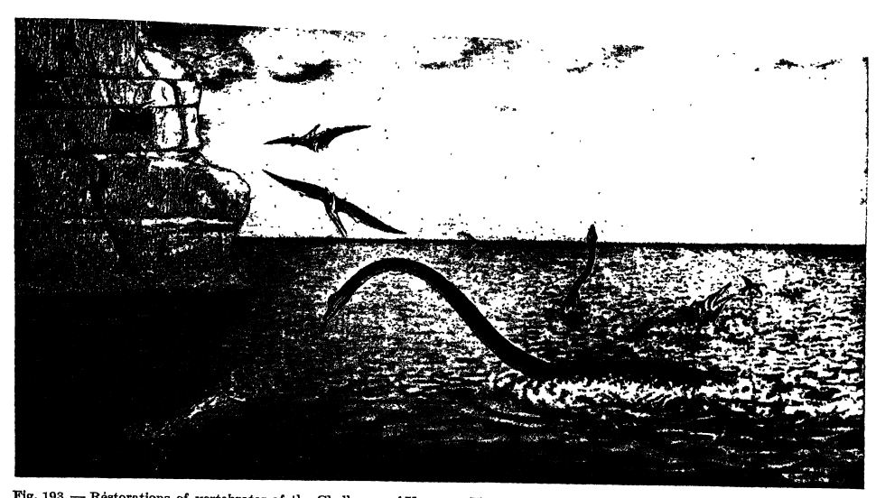
The marine faunas of the Lower Cretaceous were not of warm waters in the far north, for no coral reefs are known there, but their distribution was then in higher latitudes than it is now. In general we may say, therefore, that after early Upper Cretaceous time, when the marine floods were greatest, the climate the world over was milder than it is at present and that it was warm temperate in character (see Fig., p. 555).
Udden in 1918 described and illustrated what may be casts of ice crystals, indicating that winters with frost prevailed throughout the area of Texas and northern Mexico during the early part of the Upper Cretaceous (Eagle Ford) and the later part of the Lower Cretaceous (Del Eio). Shortly afterward, during the greater part of the Upper Cretaceous (later Benton to Fox Hills) the floras have pahns, fip, and other warm-climate trees from Argentina to Greenland and Alaska. In Greenland (Atane beds) there grew breadfruit trees in addition to cinnamons, fip, laurels, tree-feims, and other tropical and subtropical plants, indicating that the climate of this far northern land may well have been subtropical.
At tihe dose of the Cretaceous in the “ Laramie” of the Great [ p. 574 ] Plains there continued to live fig and breadfruit trees and palnas, indicating a climate as mild as that of to-day along the Gulf of Mexico. In the later Fort Union, however, the climate in the Rocky Mountains was again cooler, with distinct though probably not severe winters, more like those in the present Dismal Swamp of Virginia and North Carolina.
It is very probable that climatic zones existed during the Upper Cretaceous, though not in so marked a degree as now. This is best seen in the distribution of the marine faimas, for in the Cretaceous formations of Tethys, Antillia, Mexico, and Texas, reef-building corals and bivalves (rudistids. Fig., below) are conspicuous, while in the deposits of North Europe and the American Atlantic border these animals are absent.
We have seen that the Cretaceous closed with the Laramide Revolution, and in harmony with the earlier and later diastrophic movements of similar import, one expects to find here a cold, or at the least a considerably cooled climate. In confirmation of this expectation is the discovery by Atwood and Cross in 1923 of two beds of tillites in southwestern Colorado, which have been traced over an area of 40 miles in length, and represent the work of Alpine glaciers. Their age is not certainly known, though Cross holds that they are probably of early Eocene time, just when the Laramide Mountains were most extensive and highest.
There is now good evidence of glacially striated stones of wide [ p. 576 ] [ p. 577 ] distribution in late Cretaceous deposits of central-southern Australia. The discovery was first made b3’ Talbot and Clarke, and then confirmed bj" Brown (Benson 1923).
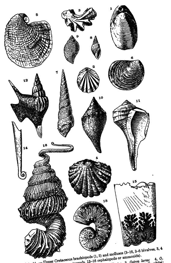
Fig. 1, Terebratula harlani, x 3; 2, Terebratella plicata; 3, Ostrea larra; 4, O. lugubris; 5, Exogyra .costata, x i; 6, Inoceramus vanuxemi, x i; 7, Turritella whitei; 8, Admetopsis subfusiformis, 9, Cancellaria malachitensis; 10, Cryptorhytis utahenais; 11, Pyropsü x i; 12, Aporrhaie prolabiata, 13, Scaphites nodosus, x i; 14, compressus, x 10; 15, fragment of an adult of same species, to show suture A and
¶ Life of the Upper Crelluxous
The most striking aspect of the life of the Cretaceous was the culmination of the dinosaurs, pterosaurs, and reptilian mammals that began in the Triassic, the toothed birds of Jurassic origin, and the marine faimas of Jurassic time. It was the final expression in the evolution of the medieval life, and out of it arose the modern world of organisms.
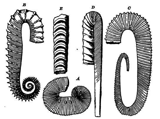
Invertebrates. — The marine invertebrate animals were much like those of the earlier Cretaceous (see Pl., p. 575), with the marked difference that the ammonids were making their last stand. Old age was upon them, since but few new genera arose, and their doom was foreshadowed in the uncoiling, the unnatural twisting of the shells (Pl., p. 575, Fig. 13), and the straight baculites (Fig. E, above, and Pl., p. 575, Figs. 14, 15). The genus Heteroceras displays the extreme of [ p. 577 ] irregular growth (Pl., p. 575, Fig. 16). The belemnids were still present in force, though hy no means so abundant as in the Jurassic, and they were evolving toward the squids in the loss of their internal vestigial structures.
In the fresh waters, unionids or pearl shells were common, and very much like those now living in the western streams of the United States. Fresh-water snails and land snails (Helix, Fig. C, p. 224) are also found, though less commonly.
Floras. — There was nothing medieval in the character of the later Cretaceous flora, for more than 90 per cent of the plant genera were of the woody kinds known to-day. The magnolia, fig, and sassafras trees, of Lower Cretaceous origin, were in their best development in the later Cretaceous. Other modern trees that appeared in this period were the birch, beech, maple, oak, walnut, hazelnut, plane, tulip, laurel, holly, ivy, sweet gum, and breadfruit. The giant trees of California, the sequoias, of early Mesozoic origin, were also in their ascendancy. The sedges and grasses appeared in Upper Cretaceous time, but it was not until late in the Eocene that the latter and the cereals became abundant, and thus made possible the rise of the higher or placental mammals.
Little is as yet known of the insects of the Upper Cretaceous. It appears probable, however, that most of the modern orders were then present, and also that much adaptation in the visiting of flowers to eat the pollen had already taken place, and that through this environment had come other changes modifjdng the mouth parts into tubes to suck the flowers of their honey. Through these visitations arose the dependence of plants upon their guests for pollenation.
Dinosaurs. — During Upper Cretaceous times the dinosaurs were very varied and the individuals large in size. The most characteristic were the Ceratopsia, homed animals some of which were twice as heavy as elephants (Pl., p. 485, Figs. 1-5). The duck-billed forms were large and represented by distinctively American kinds not only in the Rocky Mountains but also in New Jersey (Trachodon or Claosaurus, Pl., p. 485, Fig. 6). Large sauropods were, however, rare. Upon these various forms preyed the carnivorous kinds, among which the king-tyrant saurian (Tyrannosaurus rex, Pl., p. 485, Fig. 7), the most fearful of all flesh-feeding animals.
Until recently it was thought that the ponderous quadrupedal sauropod dinosaurs became extinct with the Upper Jurassic (Morrison) or at latest with the early Lower Cretaceous (Arundel). In 1922, however, Gilmore described the partial remains of a fairly large sauropod shoulder blade from the later Cretaceous (Ojo Alamo) of New Mexico. With this discovery, it is now all the more easy to believe that the dinosaurs of Argentina are also of late Cretaceous time and that among them were sauropod forms.
[ p. 578 ]
Near the close of the Cretaceous (Lance) the life of the land was still dominated by the dinosaurs, and nearly all were large forms. They were living in a forest of Cenozoic aspect, since the progression among the plants was ahead of that of the animals. Even though the Rocky Mountains were rising and the Great Inland Sea along whose shores in the fresh-water swamps they lived was vanishing, the dinosaurs continued on without apparent check. With the going of the last Cretaceous sea (Cannonball) these great beasts so characteristic of the medieval world died out, there being none in the Fort Union.
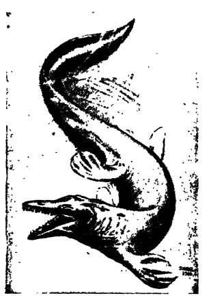
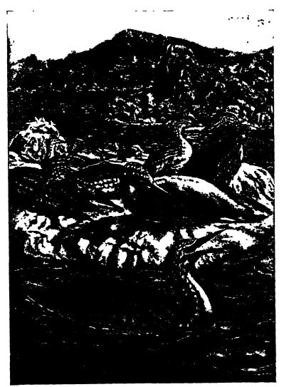
Reptiles of the Sea. — The seas of Upper Cretaceous time continued to be dominated by reptiles. The ichthyosaurs were vanishing, but the plesiosaurs attained their culmination, for a form has been found in Kansas which had a length of 40 to 50 feet, of which 22 feet was neck (Elasmosaurus, Fig., p. 559). The crocodiles were represented by the ancient broad-nosed, long-headed type (Teleosaurus), and by the first of the slender-nosed kinds, such as the gavials living to-day in the rivers of India and Borneo. Of marine turtles, at least one kind was present; the largest specimen known was nearly 11 feet long, with a breadth across the front flippers of 12 feet (Archdon)- But the most interesting of the newly appearing animals were the scaled reptiles known as mosasaurs, which were confined to the Upper Cretaceous. They swarmed in the shallow seas along the Atlantic border and the Gulf of Mexico, and especially in the seas of Kansas. The mosasaurs were gigantic, carnivorous, marine lizards, ranging in length up to 35 feet, with the limbs modified into aw imming paddles (see Fig., above).
Toothed Birds. — The last of the toothed birds are seen in the Upper Cretaceous of Kansas. They are discussed in Chapter XL.
[ p. 579 ]
Mammalia. — Many jaws of diverse kinds of mammals have been found in late Cretaceous deposits (early Lance) of Wyoming and Montana, but they did not as yet play an important role among the land animals of their time; nearly all were still small and of archaic character. Later, in Fort Union time, and immediately after the dinosaurs had vanished, they began to attain laiger size and tended to become the dominant animals of the lands. At
Great Mortality of Cretaceous Time. — We have learned that early in the Upper Cretaceous the oceans began to spread over the [ p. 580 ] continents, and that this transgression was one of the greatest of the geologic past (see Fig., p. 555) . It therefore is interesting to note that even though there was great opportunity for expansive evolution, but few new marine stocks appeared. On the contrary, it was rather a time of death to many characteristic ones. Entire races of specialized forms vanished, just as other stocks did under sim i lar circumstances (= critical period) at the close of the Paleozoic. In late Cretaceous times it was the ammonids, belemnids, rudistids, and other stocks of molluscs which disappeared. In addition, there was a great reduction among the reef corals, the replacing of the dominant ganoids by the teleosts or bony fishes, and, finally, the complete djTng out of the various stocks of marine saurians.
On the land, with the establishing of the highest or flowering plants, we see the vanishing of the dragons or pterodactyls, and, near the close of the Cretaceous, the last of the dinosaurs and the birds with teeth; they were overwhelmed by climatic changes and the rise of the mammals; in the air they yielded to the more finely organized birds — in short, the reptilian dominance was destroyed with the end of the Mesozoic era, during which entire time they had been the characteristic animals of the sea and even more of the land.
The great reptilian bubble swelled up and burst at the close of the Cretaceous, leaving behind a few crocodiles and lizards for to-day. Out of the crash of the reptilian overgrowth and extravagances the birds emerged with a promise stOl ahead, while the mammal line leading into man traveled clear of the hindering excesses (Clarke).
¶ Economic Products
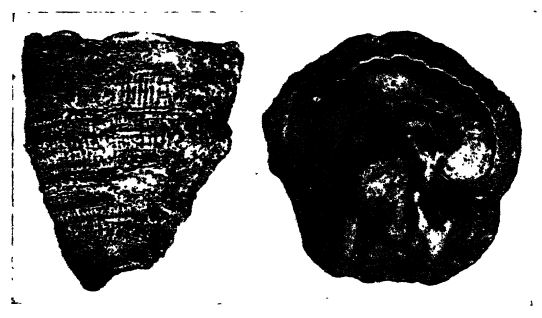
Coal. — Just as the Pennsylvanian, at the close of the Paleozoic in eastern North America, was the period of greatest coal making, so was the Upper Cretaceous in the Rocky Mountains coimtry at the close of the Mesozoic (see Fig., p. 402). Some coal was laid down in all of the formations of the Upper Cretaceous, but most of it in the closing time of the period. It is coal formed in sllu, in local swamps ranging from Arizona Into Canada, and occurs in both thin and thick beds (even up to 86 feet), and, as in the Pennsylvanian, usually in many superposed beds. These coals are composed in the maiTi of conifer woods, of sequoia or “ big trees,” cypress, juniper, fiir, and spruce. Throughout the Rocky Mountains of the United States there are more than 100,000 square nules of coal-beaiing lands, and Colorado alone is estimated to have 34,000,000,000 tons of available coal, most of which is of Upper Cretaceous age. These coals range in grade from lignite to anthracite.
[ p. 581 ]
Petroleum. — Much natural oil is being mined out of the Upper Cretaceous strata of Montana, Wyoming, and Texas, but in greatest amount in the Gulf coastal plain of Mexico. Here there are two main producing areas, (1) the Tampico-Tuxpan, and (2) the Tehuantepec-Tabasco. The wells are down between 2000 and 3000 feet. Single wells have yielded 260,000 barrels per day, and one has given 40,000,000 barrels in five years. Mexico has been the third largest oil-producing country, but at present the yield is greatly reduced due to salt water entering the wells.
Gold and Silver. — Lindgren says that from Cape Horn to Alaska the gold and silver deposits of the Cordilleras were formed under similar geologic conditions, at different times between the earliest Cretaceous and the present. They are the products of the igneous activity that accompanied the rise of these gigantic mountains. The hot waters ascending from the molten rocks carry in solution gold and silver, and on becoming cold, deposit the metals in what are known as primary or original deposits. The placer gold is derived from the primary veins through their disintegration under weathering influences.
In North America the annual yield of gold now has a value of about $130,000,000 and silver of about $100,000,000. This yield is ten times greater than the present production of South America. Mexico is the greatest producer of silver and during the past four centuries has yielded 122,500 metric tons. Colombia, Chile, Bolivia, and Peru have also produced greatly in the past.
¶ Collateral Reading
References relating to the Mesozoic-Cenozoic Boundary in North America
T. W. Stanton, The Fauna of the Cannonball Marine Member of the Lance Formation. U. S. Geological Survey, Professional Paper 128-A, pp, 1-66, 1920.
C. Schuchert, Are the Lance and Fort Union Formations of Mesozoic time? Science, new series, Vol. 53, 1921, pp. 45-47.
W. Cross and F. H. Knowlton, Are the Lance and Fort Union Formations of Mesozoic time? Ibid., new series, Vol. 53, 1921, pp. 304-308.
W. D. Matthew, The Cannonball Lance Formation. Ibid., new series, Vol. 54, 1921, pp. 27-29.
W. D. Matthew, A Note on the Cemaysian Mammal Fauna. American Journal of Science, 5th series, Vol. 1, 1921, pp. 509-511.
W. D. Matthew, Fossil Vertebrates and the Cretaceous-Tertiary Problem. Ibid., 5th series, Vol. 2, 1921, pp. 209-227.
F. Ward, The Lance Problem in South Dakota. Ibid., 5th series, VoL 7, 1924.
J. W. Gregory, The Rift Valleys and Geology of East Africa. London (Seeley, Service and Co.), 1921.
E. Krenkel, Die Bruchzonen Ostafrikas. Berlin (Bomtraeger), 1922.
| XXXVIII. The Lower Cretaceous, and the First Appearance of Flowering Plants (Angiosperms) | Title page | XL. The Toothed Birds of Medieval Times |