| XL. The Toothed Birds of Medieval Times | Title page | XLII. The Evolution of Mammals and the Rise of Mentality in the Cenozoic |
[ p. 588 ]

Long ago Newberry said that the picture which Geology holds up to our view of North America during the greater part of Cenozoic time is, in all respects but one, more attractive and interesting than could be drawn from its present appearance. Then a warm and genial climate prevailed from the Gulf to the Arctic Ocean, and most of the continent exhibited an undulating surface of rounded hills and broad valleys covered with forests, inhabited by birds and animals far more varied than any of the present day, or wide expanses of rich savannah over which roamed countless herds of mammals, many of gigantic size, of which our present meager fauna retains but a few representatives.
The Various Time Terms. — About Paris, France, the marine formations of the AngloGallic basin are interbedded with continental deposits and therefore these two usually independent records, one of the oceans and the other of the lands, are checks upon each other. The shells of the marine formations were studied by Lamarck (1818-1822) and Deshayes (1824-1837), the mammals by Cuvier (1812), and the plants by Brongniart (1822-1828). The numerical relations of the Cenozoic faimas to those of the present were first indicated by Cuvier, and followed out in detail by Deshayes and Lyell. Deshayes recognized nearly five thousand kinds of shells and the study of these led him to see that the youngest strata had the greatest number of still living species, while the forms found in the oldest rocks had the least faunal resemblance to those of the [ p. 589 ] present. He also pointed out that in the Cretaceous there are no species of the present living world, and it was this observation that led to the establishing of the Cenozoic as the era in which the present life damied. This change or evolution among the shells was taken by Charles Lyell (Fig., p. 588) in 1832 as the basis for dividing the Cenozoic formations into Pliocene (from the Greek words meaning more recent, 35 to 50 per cent ofthe species still living), Miocene (less recent, 17 per cent still living), and Eocene (dawn of the recent, 3.5 per cent still living). To these Lyell later added Pleistocene (most recent, 90 to 95 per cent still living) ; and in 1854 Beyrich separated out the older Miocene formations under the term Oligocene (little of the recent).
A wider knowledge of the marine Cenozoic molluscs has shown that this classification has permanent value, but that the percentage of living species is about as follows (see also p. 590):
The percentage of living shells in any Cenozoic formation is variable, as the above table shows, and the newer work in Japan and the Philippines, where the waters have remained continuously warm, appears to indicate that in the warm temperate and equatorial belts of the earth they may not hold at all. (Dickerson.)
During the rise of the science of Geology, the youngest era in the history of the earth was named Tertiary by Cuvier and Brongniart (see p. 453), it being thought that all earlier time was comprised in but two other eras. Later came into use the term Quaternary, which included the youngest geologic formations of more or less unconsolidated materials scattered over the surface of the earth. Since, however, Quaternary is not representative of an era of geologic time, and since six areas are now recognized by geologists, we had best abandon both these terms and use only one, Cenozoic (from Greek words meaning recent and life). Eecent time will then start when the Pleistocene continental glaciers began their final melting off northern Europe and North America, seemingly not more than 20,000 years ago.
It has long been the custom to divide the Cenozoic into two parts, an Old or Paleogene and a New or Neogene. This is done for the following [ p. 590 ] reasons. The Paleogene (Eocene and Oligocene) begins with inherited highlands that later are gradually reduced to peneplains. The climate is at first cool, but with the vanishing of the mountains it becomes warmer, moister, and equable. The Oligocene is the most widely spread warm time of the Cenozoic, and the animal life of the land and seas is still ancient. In the Neogene (Miocene, Pliocene) there is much crustal unrest, seen in the rising of moimtains, in consequence of which there appear cooler climates that attain their climax in the late Pliocene and the following Pleistocene. The life is decidedly modern.
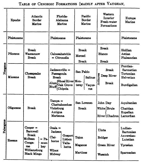
Table op Cenozoic Formations (mainly apfer Vaughan)
The question, is often asked, of what significance in chronology are such terms as Eocene, Oligpcene, Miocene, and Pliocene? Some regard them as of the value of periods, but clearly none represent the length of tirrift or show the amount [ p. 591 ] of organic evolution that the periods do in the Mesozoic or Paleozoic. It is now held that the Cenozoic represents from 4 to 5 per cent of all geologic time, while the Mesozoic endured 11 to 12 per cent and the Paleozoic 28 to 30 per cent. In other words, the whole of the Cenozoic endured no longer than the average time of a Paleozoic period, and while the evolution of the mammals is very marked, that of the other organisms is no greater than in a period of time. Accordingly the subdivisions Eocene, Oligocene, Miocene, Pliocene, and Pleistocene are here treated as epochs of time or series of strata.
¶ Part I. The North American Cenozoic
Areas of Marine Sedimentation
The seas of Cenozoic time in North America, excepting in CaEfomia, were typically marginal overlaps of the oceans, and were of the nature of sheE seas. There were almost no inland or epeiric seas, in contrast to their dominancy during the Paleozoic and less markedly during the Mesozoic. The marine overlaps oscillated back and forth repeatedly and variably in the different areas of invasion, but at no time was more than 6 per cent (Middle Eocene) of the present area of North America under water, while the average for the Cenozoic was about 3 per cent or even less. If, however, we include Central America and the Antilles, the total percentage may rise to 10 per cent, with the time of most marked flooding during the Oligocene epoch (Pl., p. 593).
In Europe and Asia, the marine overlaps were also less extensive than during the earEer eras, but Tethys continued in full extent from western Europe to India, and attained its greatest spread in OEgocene time. Its connections with the Atlantic were limited, and for a time it had Arctic connections east of the Urals. The Alps of southern Europe and the Himalayas of India began to rise in the Miocene and then the eastern half of this extensive middle ocean began to vanish more and more. In the PEocene, Tethys had attained about the area and the general configuration of the present Mediterranean; but in these alterations the remaining areas of former shallow seas had been changed to a chain of great basms of oceanic depths — an epeiric sea had given way to a mediterranean ocean.
The capital cities of many European countries are built on Cenozoic strata, among them London, Paris, Brussels, Borne, Vienna, and Berlin.
In southern Europe, northern Africa, Asia Minor, India, Burma, Siam, Sumatra, and Java, the stratigraphic and tectonic history is that of Tethys; in eastern Asia, Melanesia and Australasia, the very intricate record is that of the Pacific. These two types of [ p. 592 ] mountains meet in the Dutch East Indies to the north of Australia. In North America there were marginal pulsations of the Atlantic, the Gulf of Mexico, and the Caribbean, but along the Pacific the history is more in harmony with that of eastern Asia.
Degree of Consolidation of Strata. — Where the Cenozoic strata have not been deformed, they are apt to be unconsolidated and soft, as in the marine formations along the Atlantic border and in the continental deposits of the Rocky Mountains. Along the Pacific coast, however, nearly all of the formations older than the Pleistocene are folded or otherwise altered so that they are as much consolidated as are the formations of the Paleozoic.
Overlaps of the Atlantic Ocean. — Wherever the contact between the Cretaceous and the Eocene has been seen from New Jersey to central Mexico, the Eocene sea advanced across a land surface which had reached an old or nearly base-leveled stage of erosion, as is shown by the almost horizontal contacts (see Fig., p. 561). Not a single species of the Mesozoic is known to pass this break into the Eocene. Much of the time of this break is represented in the Rocky Mountains by continental deposits, the Lance, Fort Union, Puerco, and Torrejon, which in this book are referred to the Mesozoic.
The Cenozoic deposits of the Atlantic Coastal Plain north of North Carolina (Cape Hatteras) are not at all as well developed as those in the states bordering the Gulf of Mexico, and no Eocene strata are present north of New Jersey. A limited Lower Eocene development of marine greensands and marls not over 225 feet thick occurs in Maryland, Delaware, and Virginia. Upon these follow, after a long interval of land conditions, the Chesapeake Miocene sands, clays, marls, and diatomaceous earth, with a thickness ranging up to 475 feet (see Pl., p. 593). Marine Pliocene strata are of very limited and occasional development.
All of the Cenozoic strata dip toward the Atlantic Ocean, or the Gulf of Mexico.
Along the eastern Gulf Coastal Plain from Cape Hatteras southward and westward, the marine Cenozoic is well represented, with the longest sequence of the older strata in Alabama and Mississippi and of the younger ones in Florida. In the north, toward the old shore, it is a variable series of sands, greensands (glauconite), and marls, with more or less of lignite beds, while in Florida occurs an unequaled development of Oligocene and Miocene. limestones and marls, with but little sand. The thicknesses are variable, often under a few hundred feet, and at best attain to over 2000 feet. In Florida the [ p. 593 ] formations above the Eocene reach 2500 feet in depth, and in that state the Oligocene is profuse in invertebrate life.
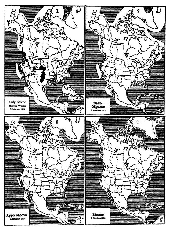
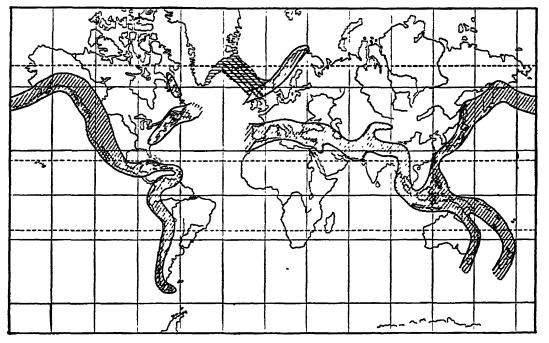
Epeiric and shelf seas dotted; oceans ruled. Presh-water deposits with land life in solid black; these areas, however, have the combined Cenozoic formations. Volcanic regions indicated by crosses.
Note that all geosynclines have vanished excepting remnants of the Pacific one; also that North and South America are separated by the Panama portal, at the time of the greatest submergence of Antillis (Map 2).
[ p. 594 ]
In the embayment of the Mississippi valley extending to southern Illinois occur only Eocene fresh- and brackish-water sands and clays, with beds of lignite (see Pl., p. 593), the plant accumulations of former swamps. These are the sediments of the ancient delta of the Mississippi River when the shores of the Gulf of Mexico were at Cairo, Illinois. Later, in early Oligocene time, the sea had withdrawn to middle Alabama (see Pl., p. 593).
Westward from the Mississippi River on the western Gulf Coastal Plain, the older Eocene is well developed into Texas and northern Mexico, while the younger Eocene is not known west of the Red River of Louisiana but is again sparingly present in northeastern Mexico. These marine, brackish-water, and swamp deposits of sands, clays, greensands, and lignite beds attain to a maximum thickness of 2000 feet. Since Oligocene time the great stream of fresh water from the Mississippi River has not only had its influence on the sedimentation of this area, but has also prevented the intermigration of the shallow-water life to the east and west of the river.
The Oligocene formations are well developed in Ijouisiana, where they are essentially fresh-water sands and green clays, reaching a thickness of 1600 feet. In Texas these strata are practically unknown, but in Mexico they occur as narrow overlaps. West of the Mississippi River Miocene strata are known only in deep wells, and at Galveston, Texas, they are 2300 feet beneath the surface, showing the extent to which the eastern margin has been warped beneath the sea since late Miocene time. Of Pliocene strata there is but a small development in Mexico. (See Pl., p. 593.)
There are no marine deposits of the early Eocene known in Central America, and hence we may assume that at that time and during the late Cretaceous North America and South America were united by a land bridge wider than the present one. This connection permitted the land life of the two continents to intermigrate. During later Eocene time, however, and more especially throughout the Oligocene, the Caribbean Sea spread widely across southern Central Ajnerica and some of the Atlantic Eocene molluscs migrated to California and South America. During the earlier Miocene the two continents still remained separated, and they were not reunited until late Miocene time. Even though the Central American land was wide, the land bridge does not appear to have been a favorable one for intercontinental migration of land animals. This may have been due to the mountainous and volcanic nature of the region, but more [ p. 595 ] probably to the barrier of the tropical jungle. The Caribbean did not again invade this land until Pliocene time, and then only marginally. (See Pl., p. 593.)
The Greater Antilles, Cuba, San Domingo, and Porto Rico appear to have been large land areas during the earlier Eocene, and it further seems that Cuba was then connected with Central America. In the Oligocene, however, all except the mountainous central portions of these islands were beneath the sea, whose waters were tropical and abounded in a very varied life. The record begins with local shallow-water formations of dark to black shales and ferruginous sandstones up to 1000 feet thick. These are followed by the widely spread white foraminiferal limestones and marls varying in depth from 700 to 2600 feet. From this it appears that it was during the Oligocene that, the oceans most widest flooded the Antilles and Central America.
Elevation of the Antilles again took place early in the Miocene, but it is not yet established that Cuba was then or at any time subsequently in connection with Central America. The living native mammals of the Antilles are small, of but a few kinds, and of ancient types. None of the larger North or Central American mammals appear to have reached these islands. In the Pleistocene of Cuba, however, there are several species of ground-sloths that Matthew believes are all derived from a single small form thought to have drifted there on a natural raft across the Caribbean from South America. For the earlier history of Antillis, see page 570.
Seas with Pacific Waters. — Almost all of oar knowledge of marine Cenozoic invasions along the Pacific is restricted to the states of California, Oregon, and Washington, and nortnward into the Vancouver area of Canada. There appears to be no sedimentary record along the shores of British Columbia and Alaska imtil late in Miocene times, and even this marine overlap was of small extent (see Pl., p. 593),
In most places the Cenozoic rests unconformably upon the Mesozoic or older rocks, though at times the contact is a disconformable one. In California there are other unconformities in the Miocene, and at the close of the Pliocene. Arnold states that about 25,000 feet of strata were accumulated during the Cenozoic, but if we take the maximum thicknesses for all the formations the total rises to about 45,000 feet. In the main the deposits are coarse detritals, as sands, muds, and much volcanic ash with local lava flows. The seas were shallow and in places became filled with sediment and then passed into marshes, making coal beds, as was especially the case in the estuary of the Puget Soxmd region, where 125 coal beds occur. The times of most marked and general sedimentation were in the early Eocene (8000 to 12,000 feet) and the late Miocene (8000 feet in California). In the Pliocene and Pleistocene, 13,000 feet of sands and volcanic materials were laid down south of San Francisco.
[ p. 596 ]
Throughout Alaska and extending into British Columbia occurs the widespread Kenai formation of continental character, which has a maximum thickness of 10,000 feet. It has much plant material and many beds of lignite, with some marine animals that indicate the age to be Eocene.
It is not yet clear to what extent during the Cenozoic Alaska was united with Siberia, though it seems that the ocean did not invade the Bering Strait region until late in Miocene times. If this land bridge between Asia and America was not in continuance throughout all of this time, it was during most of the era. Since the Pliocene the bridge has been crossed by the sea at different times, though at no time was this very shallow sea much deeper than it is now.
Continental Deposits of the Rocky Mountains. — Fresh-water and eolian deposits of Cenozoic time cover great areas in the United States, chiefly in the foothills and the plains country east of the Rocky Mountains (see Pl., p. 593, Map 1). It should be clearly understood, however, that the deposits consist of a large number of separated formations, laid down by many large and small rivers over their flood plains, now here and now there throughout the Cenozoic. As a rule, the strata remain horizontal and are somewhat consolidated into sandstones, sandy shales, and local conglomerates. Volcanic ash in thick beds or reworked by water and wind occurs in most of the formations and constitutes a considerable amormt of the Cenozoic rocks of the plains country. Nearly ever 3 rwhere the strata are exposed to view in more or less locally dissected places where the rain, streams, and wind of the present semiarid climate have worn them into those picturesque areas known as “ bad-lands ” (see Fig., p. 35 of Pt. I). The thickness at any one place varies from a few hundred feet to several thousand but if all the thickest local deposits are combined the total Cenozoic sedimentation attains to well over 20,000 feet. It is in this vast mass of material that lies buried the most interesting known record of mammalian evolution, the remains of one organic dynasty after another, whose histories have attracted the attention of paleontologists the world over.
The older geologists stated that these strata had in the main been laid down in lakes of vast extent. During the past twenty years, however, it has been shown that they are the materials of rivers originating in the mountains, and meandering and rmloading over great flood plains under a more or less semiarid climate. In addition there is also a great deal of wind-borne material, desert dust, and fine volcanic ashes from the western volcanoes, that at times killed and buried the flora and fauna over considerable areas. This ash came m greatest mass during the Eocene, Oligocene, and Miocene.
[ p. 597 ]
¶ The Unfolding of Cenozoic Events in North America
Eocene Epoch. — Eocene time is the first and the longest enduring of the Cenozoic epochs. It is out of the life of this time that the present organic world dawns, with the degree of organic progress most marked in the marine molluscs and the land mammals. While many genera of Mesozoic origin continue into the Eocene, none of the marine species do. This marked break in the continuity of the organic world is explained by the absence of strata connecting these two records. The marine break is longest, and in England and America the lost record may be as long as the whole of Cenozoic time. In the fresh-water deposits the hiatus is far less but nowhere is there a complete transition.
In the Eocene marine faunas, there are at no time more than about 5 per cent of living species, and therefore the dawn of the Recent is not yet marked. In late Eocene time the mediterranean Tethys was of very wide extent and its warm waters swarmed with shellmaking and ground-living Foraminifera, the latter comprised under the term nummulites, because of their resemblance to a Homan coin (nummulus). The limestones made by these little animals are in places several thousands of feet thick and furnished the building stone for the pyramids of Egypt.
After the deposition of the latest Mesozoic fresh-water deposits (Fort Union, Puerco, and Torrejon), uplift combined with much volcanic activity followed in the area of the Rocky Mountains. In consequence there resulted in the plateau area during the earlier Eocene a long deposition of intermontane continental formations (Wasatch, Wind River, Green River, and Bridget). They cover an area 450 by 250 miles and vary in thickness from 2400 to over [ p. 698 ] 10,000 feet, the greater part of which consists of ash and coarse igneous detritals. They have a marvelous record of successive mammal faunas.
Green River lake of middle Eocene time, covering at least 350 by 150’ miles, was shallow and lay near sea-level. Many of its deposits are bluish black in color and abound in petroleum that will some day be distilled from them. From these deposits have been described 80 species of plants (palms, figs, planes, etc.), 280 kinds of insects, 35 fishes, one of which is 6 feet long, and the complete skeleton of a bird. Among the fishes are 8 kinds that are clearly of the sea, showing that they got into this lake to spawn by migrating up some imknown river. One of them is a sting-ray.
In the latest Eocene (Uinta) the formations are much thinner, averaging about 3000 feet. These various Eocene deposits are best developed in w-estem Wyoming, eastern Utah, and western Montana. In them lies buried the most wonderful record anywhere of archaic mamm als, hold-overs from the Mesozoic world, together with an unfolding sequence of modernized animals. Where these heralders of the Cenozoic came from is unknown but it is thought most probably from Asia. All through the Eocene there is contest between the native and immigrant mammals for the habitats, and the supremacy is seen to lie with the latter, due to their greater mentality. At first there was free migration with Europe but after Wasatch time the interchange soon ceased. The succession of these mammals is described in detail in the next chapter.
During Eocene time the holarctic continent Eris (see Fig., p. 555) permitted wide radiation of its land life east and west throughout Eurasia and North America. The same appears to be true for a greater Antarctis, which connected not only with South America but seemingly with Australia as well. North and South America were also united toward: the close of the Mesozoic and during much of the earlier half of the Eocene.
Oligocene Epoch. — The Oligocene was the warm time of the Cenozoic and the lands were peneplained through erosion to their least elevation above sea-level. The streams meandered widely and the climate during the earlier and greater part of the epoch was in most places moist and therefore continued the general prevalence of forests with the kinds of trees like those of the Eocene. Hence most of the mammals were still browsers. The last of the large and diversified crocodiles lived then.
The White River fresh-water deposits of sand and ash of the Rocky Moimtains area are of wider distribution than are those of [ p. 599 ] the Eocene, occurring in Nebraska, North and South Dakota, Wyoming, Colorado, and Montana. They are also much thinner, not averaging much above 500 feet in thickness, but are most important for the mammals they contain. In Oregon are other deposits of this epoch, the John Day intermontane formation, consisting largely of from 3000 to 4000 feet of volcanic ash and tuffs, and also yielding many mammal remains. During White River time there was again interchange of mammals between America and Europe.
Oligocene marine life is particularly well developed in the Gulf States east of the Mississippi River and in the Antilles, but along the Atlantic border there are no Oligocene deposits at all. In the Gulf area it is warm-water life, profuse in molluscan species, and abounding in reef-making corals, but the dawn of the Recent is not even yet strikingly at hand, since in the life of this time there are not over 15 per cent of living species. Florida appeared in late Oligocene time as a small island, and has been a peninsula since the Pliocene.
Miocene Epoch. — The marginal seas of Miocene time were not large along the Atlantic and Gulf States, but in the Califomic geosyncline there is a long record in ver>" thick deposits, made up largely of ash and the siliceous tests of microscopic plants, the beautiful diatoms. The dawn of the Recent is now strikingly at hand, since nearly one half of the molluscs are of kinds still living. The Atlantic waters were cool and this is best shown in the Chesapeake formation, known to extend all the way from Massachusetts to Alabama. These cool waters with their life came from the Arctic Ocean, and indicated that the old holarctic land Eris had been broken through between Greenland and Norway in about Middle Miocene time. This letting of cold waters into the Atlantic, Dali says, brought on the most marked change of any in the marine Mollusca of Cenozoic time (see Fig., p. 609).
In the Rocky Mountains area, elevation was again going on, resulting in drier and cooler climates. Volcanoes were numerous and active. The fresh-water formations are many (Arikaree, Harrison, lower Loup Fork, Clarendon, and Deep River), there is also more ash again present, and the grain of the strata is coarser in the west and finer in the east, proving their western origin. The thickness of the formations varies between 400 and 2300 feet, with the main areas of deposition in Nebraska, Kansas, and northeastern Colorado. In these deposits there is also a great array of entombed mammals, and there was another interchange of them with Europe [ p. 600 ] in Deep Biver time, when primitive elephants came from Asia. There was also renewed intermigration with South America in late Miocene time.
About Florissant, Colorado, there was a lake in the later Miocene, surrounded by active explosive volcanoes. The ashes from them fell into these waters, entombing a known flora of 250 species, and more than 1000 kinds of beetles, ants, flies, and other kinds of insects. Other Miocene lakes existed ha southwestern Colorado.
The climate in Miocene time became drier, and the forests, in consequence, more greatly reduced in areal extent. The grasses took possession of the open spaces, and these changes in the plant world revolutionized the food conditions among the herbivorous mammals.
In Middle Miocene time intermigration was again established between America and Asia, and the rhinoceroses and the long-faced elephants spread into the New World. About this time or more probably later, intermigration again took place with South America, and this interchange was greatest during the Pliocene epoch.
Pliocene Epoch. — During the Pliocene, North America was more emergent than at any other epoch of the Cenozoic, and there is therefore but little of marine life to describe. Elsewhere it is seen to be very much like that of the present.
In the Rocky Mountains, Pliocene formations (upper Loup Fork, Blanco) are widely scattered but of limited extent, and they are not very well imderstood. The whole of the Cordilleras were being elevated and in consequence the climate became more arid and much cooler. Most of the larger mammals were exterminated, but those of the earlier Pliocene closely resembled the ones living to-day in central Africa.
The Pleistocene epoch was a critical time in the organic world, the balance being disestablished by a very cold climate, but in all of this adversity man arose to take possession of the earth. What these conditions and changes were will be described in two subsequent chapters.
¶ Life Characteristics in North America
The Cenozoic is the Age of Mammals since they are present in greatest variety and number and dominate the life not only of the lands but as well of the seas and oceans. In the later Eocene occms the first mammal adaptation to an oceanic life, in the form of whalelike animals (Zeuglodon). In the Oligocene came the sea-cows, and in the Miocene the true whales, seals, and sea-lions. The [ p. 601 ] evolution of the mammals and their kinds are described in special chapters following this one.
The toothed birds vanished with the Cretaceous, and with the Eocene began the evolution of the modern kinds, ilost of the living birds trace their ancestry back to the Eocene, and in this epoch a conspicuous element was the flightless land-living birds resembling modern ostriches. More detail as to the Cenozoic birds will be found in Chapter XL.
The wonderful reptile development of the Mesozoic is nearly all gone in the earliest Eocene and at no time during the Cenozoic did these animals play a conspicuous role. Turtles, alligators, and crocodiles are of largest growth in the Oligocene, while lizards and snakes become decidedly more varied and live in all of the warmer habitats. The venomous snakes originated after Eocene time.
The land floras of the Cenozoic had arisen in the Cretaceous and the woody trees and bushes were much like those of the present. The grasses and cereals, originating late in the Cretaceous, did not take full possession of the open places until Miocene time, and then their abundance led to much adaptation and evolution among the herbivorous mammals. The palms were especially abundant in the first half of Cenozoic time, and throughout this era the sequoias were of world-wide distribution. To-day but two species are living in isolated areas in California, where some of the individual trees are known to have attained an age of upward of 3000 years.
More than six thousand species of Cenozoic insects are known, and it may be said that the fullness of insect life was attained in the Miocene. Ants are very old animals, and their origin appears to go back to Jurassic or even earlier times, although the oldest known fossil forms are foimd in the Lower Oligocene ambers of the Baltic region. Wheeler has determined about one himdred kinds of ants in these ambers, of which twenty-four are still living. See also page 515.
In the seas and oceans of Cenozoic time, the shelled molluscs attained their greatest progression in variety and numbers, and it is this evolution that is at the basis of Cenozoic chronology. Of the grand array of Mesozoic ammonites not a single one passed into Cenozoic time. The bivalves were particularly common and modern, and prominent among them were the many kinds with large siphons, the shell being buried in the mud. Oysters attained their climax of development in the Miocene of California, where the giants had a length of 13 inches, a width of 8 inches, and a depth of 6 inches.
[ p. 602 ]
Corals in the Cenozoic were not more conspicuous thaoi they are now, and the variety no greater. Finally, attention should be directed to the wonderful array of living crabs, which had their origins in the many forms of the Oligocene and Miocene.
¶ Climate
In the area of the Rocky Mountains, David White states that the climate toward the close of the Cretaceous (Laramie) was as warm as at present along the Gulf of Mexico. Later (Fort Union) the temperature was cooler, mth distinct winters like those of the present Dismal Swamp of Virginia. During early Eocene (Wasatch and later) the climate was cool and semiarid.
Atwood in 1913 discovered at a number of localities in the San Juan Mountains of Colorado beds of tillites, ranging in thickness from 80 to 100 feet. The material was derived from high moimtams fully 40 miles away, which then stood to the south and southeast of the present till areas. The tillites unconformably overlie the Cretaceous and are covered by Eocene tuffs, indicating a probable early Eocene age. It is to be expected that other areas of these tills will be foimd, in which event it will appear that the Laramide mountains were then widely covered by alpine and piedmont glaciers.
Blackwelder and Sayles have shown that the early Eocene shales of Green River age are distinctly banded, and this strongly suggests seasonal deposition. Toward the close of the Eocene, however, according to White, the floras of even arctic lands show the return of mild climates, as mild as that of the present GuK States. Along the Yukon then lived cycads, magnolias, firs, and delicate ferns.
It has long been recognized that during the late Eocene and all of the Oligocene there were world-wide genial climates. Furthermore, up to the close of the Oligocene the climates of North America were moist and the lands lay near sea-level. With the Miocene, however, the lands in many parts of the world began to rise into mountains, and gradually the climates became cooler and drier. More or less of desert climates developed in the Cordilleran areas of North America and have prevailed there ever since. In the Miocene, parts of Eris foundered, separating Greenland from Norway and Scotland, and colder waters spread all along the Atlantic shores of North America. This evidence is recorded in the Chesapeake formation which, according to Dall, has a cool-water fauna. The climate continued to grow cooler, and in the Pleistocene occurred one of the two most marked facial climates known to geologists, described in Chapter XLV.
[ p. 603 ]
¶ Part II. Mountain Making and Origin of Present Scenery
Cascadian Revolution in North America. In the chapter on the Cretaceous it was stated that the Mesozoic era in North America was closed by the Laramide Revolution, when the Laramide mountains (practically the Rocky Mountains) were folded and thrusted toward the east (see p. 567). This orogeny, however, was not all of one time, since the first movement came just before the deposition of the Fort Union formation, followed by a long quiescent time and the laying down of these sands and muds. Then at the close of the Fort Union took place the final and greater movement of the Laramide mountains. Eruptions, mainly of an explosive character, continued, though with diminishing force, throughout Eocene and Oligocene time, but the earth-shell remained fairly stable, enabling the atmospheric forces to reduce greatly the high elevations of the Laramide mountains.
In Middle Miocene time the Pacific States were again in the throes of mountain making, and igneous eruptions became active, with the formation of highlands in eastern Washington and Oregon, and at the same time came the second period of elevation of the Coast Range of California (see Pl., p. 593, Map 3). It is interesting to note here that the great San Andreas earthquake rift of California, which extends for 600 miles southeast into the Mohave desert, had its origin at this time.
At the close of the Pliocene or early in the Pleistocene, the Sierra Nevadas were elevated bodily from 5000 to 7000 feet and they are still going up. They are a crust block 300 miles long and 50 to 60 miles wide, greatly elevated on the eastern side, forming there a great fault with from 15,000 to 20,000 feet of vertical displacement.
During the Miocene, decided folding and faulting with volcanic activity also occurred in the Isthmus of Tehuantepec of southern Mexico, in Central America, and apparently throughout the West Indian islands. Finally, it may be said that especially during the Miocene, and less in the Pliocene, the entire area of the overlaps of the Pacific Ocean in North America (see Fig., p. 609) was being elevated, folded, faulted, and thrusted into the Pacific System of mountains. During the later Pliocene, the entire area of the Rocky Mountains and especially the plateau region of the Colorado River were further vertically elevated several thousand feet.
Eastern North America was also elevated at this time, but how much is not yet determined, and the entire Mississippi valley was raised several hundred feet, or to its present elevation. Generally [ p. 604 ] speaking, the close of the Pliocene must be regarded as a time of great deformation, bringing on the critical period in North America during Pleistocene time.
Origin of the Gulf of St Lawrence. — The St. Lawrence River below Montreal appears to be very old, and the antecedent river was seemingly older than the time of the reelevation of old Appalachis at the close of the Mesozoic. The course of the river then, as now, was conditioned by the nature and the southward slope of the hard crystallines of the Canadian Shield to the northwest and the much softer crumpled Paleozoic strata to the southeast. Furthermore, the Appalachian strata are thrusted over the crj’stallines and the river therefore naturally follows the line of weakened rocks, the Champlain overthrust or “ Logan’s line.” The outer portion of the old river valley lies between the headland of Gaspé and the island of Anticosti, and, as Clarke points out, Logan’s line in Gaspé is deflected southeastward and with it the ancient river valley. Farther southeast it has cut itself through the Appalachian folds and the river flows through what is now Cabot Strait into the Atlantic between Cape North of Cape Breton and Cape Ray of Newfoundland. All of this is well shown on the Admiralty charts. Far to the southeast of Newfotmdland, in the area of the fishing banks and beyond, lies the deeply submerged delta of the St. Lawrence. This is something of the history of the river, but the subsidence and the origin of the Gulf of St. Lawrence appear to be of very recent date, of latest Pleistocene time, since no older marine fossils are known along its shores. In any event, the faulting now seen off western Newfoundland and the subsidence of the gulf are of Pleistocene origin. The amount of this subsidence is at least 600 feet and in latest Pleistocene times it was over 1200 feet. (See J. M. Clarke 1913.)
Origin of the Gulf of California. — There is no evidence throughout Mesozoic time of the Gulf of California. In late Eocene time (Claiborne) marine waters began to overlap the southern end of Baja California, and we may conclude that the inbreaking of the Pacific and the formation of the ingression gulf began early in the Eocene.
The foundering of the lands into the gulf was most extensive during the early Miocene, when marine waters (Carrizo Creek) extended into southeastern California, as far north as the San Bernardino Range. These marine waters of Miocene time teemed with corals, oysters, and numerous other kinds of shells, which in many places in the Colorado desert are strewn over the groimd. Even more interesting is the fact that many of these marine animals are of Antillean (Bowden) kinds, showing plainly that the portal of Tehuantepec was again open to the interchange of waters from the Gulf of Mexico and the Pacific Ocean.
Later, when the sea retreated, the Colorado River flowed into the gulf, but it was not until the Pleistocene that it cut deep canyons, became loaded with conglomerates, sands, and muds, and filled in the head of the Gulf of California with a mighty delta. The present deepest part of this land portion of the gulf is in the west between the San Bernardino and San Jacinto mountains to the north of the Colorado desert. This was the bed of the old Salton Sea, which was again partially filled with the waters of the Colorado River in 1893 and 1907. John C. Van Dyke in his most interesting book, The Desert, calls this area the Bottom of the Bowl.” “ When you are in the bottom of it,” he says, “ you are nearby three hundred feet below the level of the sea. Circling about you to the north, south, and west are sierras, some of them over ten thousand feet in [ p. 605 ] height. These form the Rim of the Bowl. And off to the southwest there is a side broken out of the Bowl through which you can pass to the river and the Gulf. The basin is perhaps the hottest place to be found anywhere in the American deserts. And it is also the most forsaken.”
¶ Emergence of American Scenery
In general we speak of the “ everlasting hills,” and yet Geology teaches that time and again mountains have been raised and worn away. At present many lands are famous for their majestic snowcovered mountains and glaciers and beautiful hill country. Northern lands are studded by innumerable lakes that came into existence with the Pleistocene. All of this elevated scenery is destined to be worn away and the former highland areas leveled into plains that will continue imbroken into those of the more extensive nuclear or shield regions. The latter have been undulating plains since the Cambrian, and but little above sea-level. In all of this we see that the times of beautiful scenery and land sculpture are of very short duration and that during by far the greater part of geologic history the lands were monotonous in their flatness. Now let us take up a study of this subject according to the topographic regions of North America.
Interior Lowlands. — The Mississippi River lies in the center of the Interior Lowlands and the Gulf of Mexico portion of the Coastal Plain. Most of this area is underlain by horizontal strata. To the north it passes into the vast upland of the Laurentian Shield, made up of the most ancient and most deformed rocks. The Gulf Coastal Plain is at best but a few himdred feet above sea-level and in Canada the Laurentian Upland will average between 1000 and 2000 feet above the sea.
Nearly everywhere in these lowlands the rivers, inside of the coastal plains, lie in entrenched valleys, showing that these plains have recently been raised, or better, differentially warped, to a higher level which within the United States does not exceed several hundred feet. This warping took place during the Pleistocene and Pliocene. Back of this time, in the earlier Cenozoic, these plains stood at the lower level, and the greater central portion appears to have continued so back into Mesozoic time. Hence the Interior Lowlands and the Laurentian Upland have been plains ever since the close of the Paleozoic, and m general their surfaces throughout this vast time have been eroded to a depth of not more than a few hundred feet.
Appalachis. — Toward the close of the Mesozoic, the Interior Lowlands continued imbroken across the Appalachian Plateau and [ p. 606 ] the Appalachian folded land, into the eastern Coastal Plain. Then at the close of the Mesozoic and during the Cenozoic, this previouslyfolded area was bodily, and at different times variably, elevated up to a total of about 2000 feet above sea-level, and this all the way from Alabama across Newfoundland. TTith this elevation came also the mnlfing of the lateral monoclines, the narrower Piedmont Plateau in the east and the wide Appalachian Plateau on the west. On these elevated plains ever since the Cretaceous the grinding antecedent rivers have been at work entrenching themselves in deeper and wider valleys. In them the scenery is beautiful, walled in as they are by the youthful mountains on either side, but when one rises to the highest of their flat table-like tops one looks across the old peneplain of Mesozoic making. The scenery of the valleys is therefore of Cenozoic origin, and in most of them there is a stair-like series of elevated river terraces, each rising from one to several hundreds of feet, proving the periodic elevations of the region.
Rocky Mountains and Great Plains. — In Mesozoic times the Interior Lowlands continued westward, at about the same general level, to what is now the westernmost Rockj- Mountains. Then at the close of the Cretaceous came the making of these mountains and their subsequent erosion into depressed and rounded hills that melted away eastward into the Interior Lowlands. Therefore during the Oligocene the interior of North America was one vast and nearly featureless peneplain. Then in the Miocene the internal forces of the earth began to reassert themselves, and during the Pliocene and Pleistocene the area of the Rocky Mountains was raised bodily to its present altitudes. With this elevation also came into being the present vast monocline of the Great Plains that in the west stands more than 7000 feet above sea-level and in the eastern Dakotas, Nebraska, Kansas, Oklahoma, and central Texas passes into the low level of the Interior Lowlands.
Pacific Area. — The western margin of North America in the Middle Miocene again began to fold and rise into mountains, giving rise to the Pacific System. Great volcanoes then grew on the tops of these moimtmns and there are eleven areas of them between southern Mexico and Alaska. These mountains of fire were most active during the Pleistocene and the grandest of them in this country are Rainier (14,526 feet above the sea), Shasta (14,380 feet, see Pt. 1, Fig., p. 195), and Lassen (10,347 feet); in southern Mexico, Popo (Popocatepetl, 17,500 feet), the White Woman (Ixtaccihuatl, 16,900 feet), and Star (Orizaba, 18,250 feet).
[ p. 607 ]
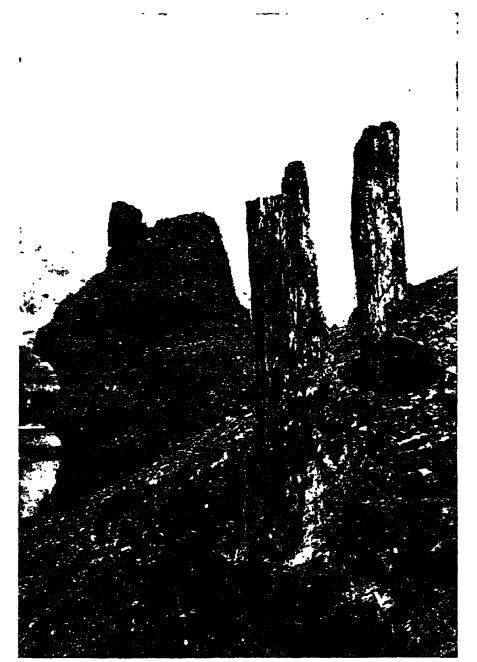
Yellowstone Park. — The Rocky Mountains also had their volcanoes and one of the most scenic and significant of these volcanic regions is the Yellowstone Xational Park, with its many hot-water ge 3 rsers (see Pt. I, pp. 230, 231). Here during Pliocene time the volcanoes in their periodic outburst of ashes buried forest after forest, and many of the trees, since changed to stone, but still standing upright, may be seen in superposed levels weathering out of the rocky sides of the hills (Fig., above).
[ p. 608 ]
Great Basin Deserts, and Columbia Plateau. — At the close of the Pliocene, or early in the Pleistocene, the Sierra Nevadas were faulted in the east and elevated vertically from 5000 to 7000 feet, and 450 miles to the east the Wasatch Mountains were faulted along their western side and raised bodily to even greater heights. Between them lies the lovrer land of the Great Basin that throughout the Pleistocene, as now, was the area of the Great American Desert. To the north of this basin country in eastern Washington, most of Oregon, and western Idaho, is the high Columbia Plateau, through which run the long and entrenched Snake and Columbia rivers. The plateau covers an area of over 250,000 square miles, five times greater than the state of New York. The greater part is a lava plain, since during the Pliocene deep fissures opened here and out of them welled time and again molten rock that finally attained to a maximum depth of 5000 feet (Fig., p. 546).
Colorado Plateau and Grand Canyon. — Between the Wasatch Mountains and the Front Ranges of the Rockies lies the highly elevated Colorado Plateau. This attained its present altitude late in the Pliocene and then began the making of the most scenic of all river valleys, the canyons of the antecedent Green and Colorado rivers and their tributaries. The gorge of the Grand Canyon of the Colorado is in places a mile deep, and its walls of horizontal strata furnish the finest exposure anywhere of the succession of Paleozoic sea bottoms, which in turn rest upon the oldest of the earth’s rocks (see Frontispiece).
Conclusions. — In all of this we see that the grander scenery of the present highlands is young, and indeed that most of it has come into being since the Pliocene. The valley scenery of the uplands on either side of the moimtains is also young, but the elevated inclined plains above the entrenched valleys are older, and vastly older stiH are the immense inland plains. These great plains reveal to us a topographic form that was not unlike that of Mesozoic time. How vastly different the life is upon them now, and what majestic brute and floral dynasties have had their being upon them we shall learn in other chapters of this book.
¶ Mountain Making in Foreign Countries
In South America toward the close of the Cretaceous the Andes had been elevated, folded, and thrusted eastward throughout the length of the continent (4500 miles), and during most of Cenozoic time an extensive peneplain was being developed in the Central Andes. From the present topographic development of the Andes, [ p. 609 ] Bowman concluded that vertical uplift began in latter Cenozoic time, elevating this peneplain from 3000 to 7000 feet. This was in turn eroded to mature slopes and then was reelevated in Pliocene and early Pleistocene time, so that now the deeph’ dissected erosion surface of the old peneplain stands at an average elevation of 12,000 feet, though locally it varies between 6000 and 15,000 feet. This plain is now the Altaplanici, the high plains of Bolma. Upon it in the west rest immense lava flows and lofty volcanic cones, some of which attain a height of 21,000 feet above the sea.
Subsequent to Bowman’s work, Singewald and Miller (1915) collected at Potosi on the Altaplanici fossil land plants. These show that the deposits are of late Pliocene age, and Berry says that the plants could not have grown at a higher altitude than from 4000 to 6000 feet. With this evidence the conclusion is now drawn that the Andes were elevated in Pleistocene time at least from 6500 to 8500 feet. This elevation was accompanied by great volcanic activity in the western ranges. The bulk of mineralization aJso dates from this time (Berry and Singewald 1921).
Eastern Greenland and the region eastward across Spitsbergen, Norway, Sweden, and Finland (Fennoscandia) were subject to great block faultings and warpings, seemingly in late Miocene time, developing not only great rifts or graben but broad sinking areas as [ p. 610 ] well, with a general trend to the northwest and southeast. This was the time when Eris was broken through, separating Laurentis from Baltis (Fig., p. 609). Previous to the Middle Miocene this land was the bridge that enabled the mammals of Europe and North America to intermigrate. Periodically, but more especially during the late Eocene and Oligocene, lava (the Thulean basalts) flowed widely through fissures over all these lands, and over eastern and western central Greenland, Iceland, the Faroe, Orkney, Shetland, and Hebrides islands, western Scotland, England, and northern Ireland (Giant’s Causeway); also Jan Mayen and Franz Joseph islands. The foundering of the crust where the Norwegian sea now is, permitted the triumphant spread of the Atlantic into the Arctic Ocean.
On page 547 it was stated in regard to Gondwana that Africa was separated from South America in Lower Cretaceous time (Fig., p. 555), and now we learn that in the Eocene the remainder of this equatorial Atlantic bridge sank, since late Eocene deposits are general along the western border of Africa. The Cretaceous remnants of Lemuris also almost all sank beneath the Indian Ocean during the Cenozoic.
In Europe, the majestic Alps are mute evidence of the great unrest of the earth’s crust during the Cenozoic, their upward culmination taking place in the late Miocene. The movement began in the west late in the Eocene, when the-Pyrenees of Spain, the Rif Moimtains of Morocco, and the Apennines of northern Italy had their origin. The entire Alpine system of western Europe began to rise early in the Miocene, and this deformation was most active late in the same epoch and was completed early in the Lower Pliocene when these mountains stood at their highest. The Eocene nummulitic limestones of the Alps are still found 10,000 feet above the sea, and those of the Pyrenees 11,000 feet. The movement was both vertical and thrusting from the south and southeast, from the southern portion of Tethys, elevating and folding the Cenozoic and older strata of the northern areas of this mediterranean into overturned, recumbent, and nearly horizontal folds, and pushing the southern or Lepontine Alps about 60 miles to the northward into the Helvetic region. Erosion has since carved up these overthrust sheets, leaving remnants lying on foundations which belong to a more northern portion of the ancient sea. Most noted of these residuals of overthrust masses is the Matterhorn, a mighty mountain without roots, a stranger in a foreign geologic environment. The thrusting was felt as a warping as far northwest as London, for the basins of London and [ p. 611 ] Paris date from this time. The Caucasus Alountains of eastern Europe, between the Crimea and the Caspian Sea, are also of early Pliocene origin, for their Miocene strata are now 6500 feet above the sea (see Fig., p. 609).
Wadia states that the Himalayas of India, as early as the Middle Cretaceous (Cenomanian), began blotting out in Asia much of the former extent of Tethys. In middle Upper Cretaceous time there was much volcanic actmty in these mountains. At the close of the Eocene, however, all of the Tethyian area of the Himalayas and Burma began to fold, giving rise to mountains of considerable altitude in many regions, and yet not e.xtensive enough to blot out the sea. During the Oligocene, Tethys, even though shallow, still preserved its continuity, accumulating thick, uniform marine deposits of gray to greenish shales and calcareous sandstones (Flysch of Swiss geologists). Toward the close of the Middle Miocene, the second and more marked phase of folding began, changing Tethys into a series of disconnected but subsiding basins, accumulating the continental deposits known as the Siwalik clays, sandstones, and conglomerates. Finally, in the Pliocene, came the third and greatest upheaval, when the Himalayas, the loftiest mountains of the earth, had peaks nearty as high as Mt. Everest of the present, which stands 29,000 feet above the sea. The nummulitic limestones of Eocene age are even now as high as 19,000 feet above sea-level, and once extended higher over the mountain axes. This uplift affected the land to the north for 1400 miles into Tibet and Mongolia, and the thrust pushed the older rocks over the newer ones in a north to south direction. (See Fig., p. 609.)
Summary. — In North America the deformation of the Laramide Kevolution was followed by a long, almost quiescent time up to the close of the Oligocene. Then unrest made its appearance in the western area of TethyS, and throughout the later half of Miocene and Pliocene time mountain making was going on in most parts of the world, in many areas on a stupendous scale. North and South America with their longitudinal chains of mountains did not change much in outline during the Cenozoic, but Europe, Asia, the Antilles, and Central America, with their latitudinal foldings, underwent marked alteration, and it was in fact in the Pliocene that these continents took on their modern expression. Finally in the Pleistocene the greater part of the Pacific Ocean was margined by majestic volcanoes. “ A great line of fire, starting with the early homes of culture in the Mediterranean, belts the earth, and branching grandly in the East and West Indies, cordons the [ p. 612 ] Pacific like the line of signal fires that flashed the tidings of the fall of Troy across the Aegean to Agamemnon in Mycenae ” (B. K. Emerson).
The Cascadian Revolution of western North America has been of long duration, beginning in the Middle Miocene and continuing into the present time. It is marked by intermittent action, pulsations of vertical uplifts, folding, thrusting, and igneous actmty, resulting in new moimtatn systems, increasing relief, and a higher continent. To us it now appears as if interrupted and finished, because we see it in near perspective. In its entirety, however, it is one of the greater revolutions of the earth, and there is no proof that the end has yet been attained. Long ago LeConte said that the Cascadian Revolution is so recent that the record of it is not lost, and a studj’ of it enables us better to comprehend the changes wrought by the earlier revolutions. In the geologic future it will take its place in the earth record through the evidence of its great foldings, metamorphism, and wide erosion of the older record — a transformation comparable to that wrought by the Appalachian Revolution closing the Paleozoic.
The closing revolution of the Cenozoic era was a critical period in the history of the earth, and as it culminated in the Pleistocene glacial climate, the conditions were all the more hazardous for the organisms that inhabited the polar and temperate regions of the earth. The warmer parts of the globe were the asylums that repeopled the northern lands, but man, probably arising in Asia even before the Pleistocene, advanced during the Glacial Period from the savage to the civilized state under the influence of cooler and even cold climates. We are now living in a time of rugged lands, obliteration of ancient peneplains, cold polar climates, and marked temperature belts.
¶ Economic Products
Petroleum. — In the Gulf Coastal Plain of Louisiana, Arkansas, Texas, and eastern Mexico, vast quantities of petroleum have been and still are being obtained. Most of it is from the marine horizontal Cenozoic formations, though some comes from undisturbed Cretaceous strata. California is another region that is producing petroleum in enormous quantities from the Cretaceous and the Cenozoic, which are more or less highly folded. The most extraordinary of all Cenozoic oil fields is, however, that of Baku, Russia, situated on the western shore of the Caspian Sea.
[ p. 613 ]
The Green River formation of the Uinta Basin, Utah, of Eocene age, has at least eighty beds of oil shale that will jield from a few to at least 55 gallons of oil to the ton, the average being about 12 gallons. It is estimated that there are here at least 42 billion barrels of petroleum and 500 million tons of ammonium sulphate (D. E. Winchester).
¶ Collateral Reading
I. Bowman, The Andes of Southern Peru. New York (Henry Holt), 1916.
C. C. O’Harra, The White River Badlands. South Dakota School of Mines, Bulletin 13, 1920.
J. C. Van Dyke, The Desert. New York (Scribner), 1901.
R. S. Yard, The Book of the National Parks. New York (Scribner), 1919
Guidebooks of the Western United States. United States Geological Survey, Bulletins 611-614:, 1915.
| XL. The Toothed Birds of Medieval Times | Title page | XLII. The Evolution of Mammals and the Rise of Mentality in the Cenozoic |