[ p. 648 ]
The Pleistocene, the final division of the Cenozoic era, and hence of geologic chronology, though brief as compared with the older divisions, was one of the critical times in the history of the earth. It was the time of the “ Great Ice Age,” and the record of the areas where the ice-fields prevailed consists in the main of a varied and most often a heterogeneous series of continental deposits, all of this being the Diluvium or deluge material of the older philosophers and the drift or tills of modern students of earth science. The bowlder beds of the ancient glacial deposits are known as tillites, while the glacially made banded clays have recently been named pellodites. Outside of the areas of glaciation the strata are in general like other continental formations laid down under moist and warmer climates. The exposed marine record is nearly everywhere very scanty, and the molluscs are almost all (at least 90 per cent) or all still Kving. The life of the land was also dominantly of living forms, though here the percentage of extinct species was greater than in the seas. The term Pleistocene was therefore proposed by Lyell to bring out the fact that the life of this time was very much like that of the present. In Europe, this time is usually known as the Quaternary.
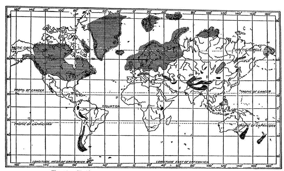
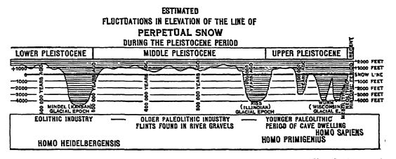
Cold Climate of the Pleistocene. — The distinguishing physical feature of Pleistocene time was its very extensive glaciation; in fact, there appear to have been a series of glaciations, for ice-sheets covering about 8,000,000 square miles of the earth’s surface existed at one time or another during this period in the temperate and colder regions of the two hemispheres (Fig., p. 649) . This is all the more remarkable when we consider that the ice-sheets were mainly of the low lands, and that the climates for a very long time previous had been mild. All of the water of these ice-sheets had been taken from the oceans and precipitated as snow on the continents. The decrease of temperature was such that the snow-line (see Pt. I, p. 120) was lowered about 4000 feet below its present limit (Fig., p. 653), and the strandlines of the oceans in the tropical and warm temperate regions, because of the abstraction of ocean water, were depressed probably [ p. 647 ] not less than 200 feet and not more than 420 feet. Finally, the loading of the lands with so much ice caused the crust to subside in the areas of the ice-sheets, while the regions immediately outside of the latter were apparently somewhat upwarped in compensation by the displaced deep-seated material of the sinking fields. The surface of the glaciated lands was therefore more or less unsteady, warping up and down some hundreds of feet in consonance with the changes going on in the ice-sheets during Pleistocene time. In addition, broad crustal movements unrelated to the glaciation had been in progress during the Pliocene and continued at intervals in the Pleistocene. As a result of these combinations of several causes the streams and shorelines generally show at the present time the marks of extreme youth — sharp gorges, drowned channels, barrier beaches, and elevated strand-lines.
Critical Life Conditions during the Pleistocene. — The development of such immense ice-fields upon the lands and the attendant reduction of temperature also meant the blotting out of vast areas on which no life or at least but little could exist. The Pleistocene was, therefore, a critical time in the history of the earth, especially for the plant and animal life of the glaciated lands and the shallow-water fife of the northern and southern oceans. The cold waters, pouring into the oceans, sank into the depths, and the conditions there also became critical for the sparse life. In the shallow waters of the warm parts of the ocean, however, there was almost no change in the environment, and consequently there is recorded here almost nothing more than the usual evolutional faunal alterations.
Recent Time. — The Pleistocene was followed by the Recent, or present time, but how long this has been going on can not yet be stated. In a general way, we may say that the estimates vary between 20,000 and 50,000 years, with the probability that the smaller figure may be nearer the truth. From a study of the glacial clays of Sweden, which there and elsewhere are laid down in layers, a lighter colored winter layer alternating with a darker and thicker summer one, De Geer concludes that that coimtry became habitable 17,000 years ago. The melting of the glaciers began earlier in Germany, hence the greater estimates given above. As man has dominated the organic world since the beginning of the Recent, this is also known as Psychozoic time, a name given it by LeConte. We are living in the opening events of a new era, the Psychozoic Era, but how long it is to last before another critical closing time appears, who can tell?
[ p. 649 ]
[ p. 650 ]
¶ General Distribillion of Glaciation
In the discussion of Pleistocene glaciation it should be recognized that the ice has only partly withdrawTi. Greenland and Antarctica are still mantled with continental ice-sheets in contrast to their unglaciated state in earlier periods. It is the excess of glaciation beyond the present areas that is to be considered in the discussion of the wide distribution of the ice-fields of the Pleistocene.
More than half of the glaciated area during the Pleistocene was in North America, and more than half of the remainder in Europe. The glaciation was, therefore, notably localized, though its effects were world-wide (Fig., p. 649).
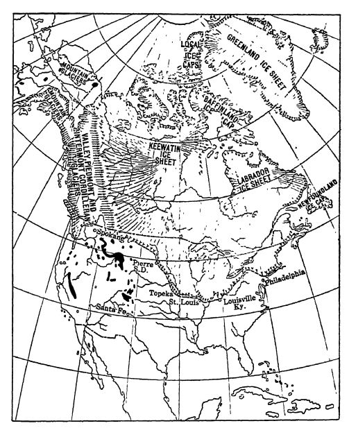
North America. — In North America it was mainly the northeastern half, and the plains country rather than the mountainous region, that was deeply buried under the continental glaciers (Pt. I, p. 124). Alaska was in the main free of ice and the same appears to have been true of the Arctic archipelago. There were three great centers of ice accumulation and radiation in North America, covering together an area of about 4,000,000 square miles (Fig., p. 651). The Keewatin ice-sheet was the most extensive, covering the great medial flat area of the continent southward into Missouri and westward into the high plains to within 800 to 1000 miles of the Rocky Mountains. The Labradorean ice-sheet was not much smaller, and extended from northern Labrador southwest ward for 1600 miles to the Ohio River. The main flow of the ice was southward toward the region of melting, marked by greater warmth. Newfoundland and Nova Scotia appear to have had independent ice-sheets, while Greenland was glaciated more extensively than now but not completely across Davis Strait so as to connect with the Labradorean mass. The Cordilleran ice-sheet covered all of the Cordilleran area from Alaska southward into Oregon, Idaho, and Montana, Farther south there were local alpine glaciers in the Rocky Mountains and in the Coast Range and the Sierra Nevadas of California (Fig., p. 651).
Some students of North American glacial deposits hold that the Cordilleran ice-sheet attained maximum spread before the Keewatin one, and the latter before the Labradorean sheet; in other words, that the maximum accumulation of ice shifted more and more to the east during Pleistocene time. In Europe, the accumulation shifted westward with time. On both sides of the North Atlantic, therefore, the shifting of ice accumulation was toward this ocean.
[ p. 651 ]
[ p. 652 ]
Other Countries. — All norihweslem Europe, Iceland, and Spitzbergen were deeply buried under ice-sheets, and the glaciers of the Alps descended far beyond their present limi ts and coalesced on the low lands in all directions. In the Himalayan region and locally in eastern Asia there were other mountains which were broadly glaciated. In the southern hemisphere, doubtless because of the absence of broad lands in high latitudes, there was comparatively little glaciation, most of it being restricted to the Andean areas. Antardica is assumed to have been as deeply covered with ice then as it is now. (See Fig., p. 649.)
Thickness of the Ice-sheets. — How thick the Keewatin and Labradorean, ice-sheets were is not known. It is widely held, however, that they must have been some thousands of feet in depth to have enabled them to flow southward with a descending grade across the higher irregularities. LeConte places the thickness at 10,000 feet over Canada and 6000 feet over New England. Daly (1915) places the least thickness at 1950 feet and says it may have been three times as great. Geologists as a rule believe that the thickness at the centers of ice dispersion could not have been less than 4000 feet, and that it may have exceeded this average depth.
¶ AllernatiTig Cold and Warm Stages
It is a well-known fact that in most areas of past glaciation there occur, between sheets of drift, beds of peat and clays with fossil leaves and wood, and sands with bones of many kinds of large mammals . These fossils show clearly alternating groups of plants and animals living in different climates; one set is of northern origin and of cold habitat, while the following one is from the south and of mild climes. The cold climate assemblages have among other forms reindeer, caribou, musk-oxen, moose, woolly mammoths (Fig. C, p. 643), and walrus, while those of the warm climates have Hons, sabre-tooth tigers, peccaries, tapirs, camels, llamas, many horses, hippopotamuses, great sloths (Fig., p. 665), the Columbian and Imperial elephants (Figs. B, D, p. 643), and the manatee or sea-cows. It is the succession of these fossils in the Pleistocene strata that has led to the discerning of alternating warm and cold climates. These marked alterations led to very extensive migrations of mammals from one part of the continent to another, as the conditions of temperature and moisture changed. During the warm interglacial times, southern species spread far to the north, as when mastodon ranged into Alaska (Fig. A, p. 643) and the sea-cow spread north to New Jersey. Increasing cold and the spread of glaciation brought about a reverse migration and drove northern and even Arctic forms far to the south. Musk-oxen then spread into Utah and as far south as Oklahoma, [ p. 653 ] Arkansas, Missouri, Ohio, and Pennsylvania; the northern or haiiy mammoth (Fig. C, p. 643) lived south of the Ohio and Potomac rivers, and the walrus had its home along the strands of New Jersey.
It has come to be generally held, therefore, that during the Pleistocene the temperature varied more than once between cold and warmer climates. During the cold times there was increase in the extent and thickness of the continental ice-sheets, and during the warmer interglacial stages the ice was melted away to a greater or less degree. However, as to the number of these alternations there is as yet no unanimity among geologists, because of the great difficulties in correlating the separated areas of glacial material, all of which are so much alike. Some geologists recognize three, and others as many as six glacial stages, with from two to five interglacial warmer times (Fig., above). The lesser number of alternations appears the more probable.
It is also now widely accepted that the interglacial times were markedly variable in duration and that all of them were not only warmer than the present, but that they lasted longer, and sometimes much longer, than the glacial stages. In Europe one of the interglacial times was so warm that the hon and the hippopotamus lived with Tna.Ti in England, and in North America the pawpaw bush spread north at least as far as Toronto, while to-day it is not known to live much above the Ohio River.
Chamberlin and Salisbury divide Pleistocene time as in the first column of the following table, and the statements concerning the mammals in the second column are after 0. P. Hay. The time estimates in the third and fourth columns are by T. C. Chamberlin (1919).
[ p. 654 ]
| After Chamberlin and Salisbury | After 0. P. Hay | Maximum Years | Minimum Years |
|---|---|---|---|
| Post-glacial or present time | Vanishing of ice-sheets. Champlain marine invasion. Lowering of water-level of Great Lakes. Gradual amelioration of climate. Gradual extinction of elephants, mastodons, Megalonyx, musk-oxen, etc. | 25,000 | 20,000 |
| Dimensions of Pleistocene time in North America | |||
| Fifth or Wisconsin glacial stage Worm stage in Europe |
Spread of ice-sheets and drift. Fauna and flora driven south. | 40,000 65,000 | 30,000 60,000 |
| Fourth or Peorian interglacial stage | Record not well determined. Formation of peat beds and soils. Wide distribution of loess. | 135,000 | 90,000 |
| Fourth or Iowan glacial stage | Spread of ice-sheets and drift. Record not w’ell determined. | 180,000 | 105,000 |
| Third or Sangamon interglacial stage | Accumulation of peats, soils, and loess. Horses, elephants, mastodons, bison, peccaries, and tapirs probably present. | 260,000 | 155.000 |
| Third or Illinoian glacial stage Riss state in Europe |
Spread of ice-sheets and drift. Deposition of loess. Apparently 60 per cent of present land fauna then living. Mastodons, mammoths, horses, tapirs, bison, deer, and sabre-tooth tigers. | 340,000 | 190,000 |
| Second or Yarmouth interglacial stage | Formation of peats, soils, and bluish loess. Animals about as in Illinoian stage. | 500,000 | 275,000 |
| Second or Kansan glacial stage Mindel stage in Europe |
Spread of ice-sheets and drift. Extinction of certain camels and horses, Megatherium, Glyptodon, and Elephas imperator. | 660,000 | 330,000 |
| First or Aftonian interglacial stage | Great abundance of mylodons, megatheres, Megalonyx, mastodons, elephants (3 species), horses (6 species), camels (4 species), sabretooth tigers, bears, etc. A warm temperate fauna. | 900,000 | 450,000 |
| First or Nebraskan glacial stage. Alachua, Dunnelion, Bone Valley | Spread of ice-sheets and drift. Includes PreKansan, Nebraskan, and Albertan drifts. A rich Pliocene mammal fauna. | 1,200,000 | 540,000 |
| Pliocene (Blanco) | |||
[ p. 655 ]
¶ Effects of the Glacial Climate
Historical. — During the greater part of the past centun’, geologists holding strictly to supposed implications of the Laplaeian theory of earth origin believed that the earth had been gradually cooling and that it became cold for the first time in the Pleistocene. When, therefore, the first announcements were made, nearly fifty years ago, that a cold climate had been present in the Permian (see p. 428) most of our colleagues of those days could not accept what is now undoubted evidence. The controversj* over the origin of the Pleistocene glacial deposits, however, not only made it possible to accept the evidence of the drifts and tills as the result of ice work, but paved the way for the evidence of other and older geologic climates. We now know that such occurred much farther back in the history of the earth, one toward the close of the Paleozoic in the Permian, and two earlier ones in Proterozoic time (pp. 171 and 174). There is evidence of yet other cool periods, and it is probable that we shall learn that the earth has undergone more than four glacial climates (see Fig., p. 445).
Changes in Drainage due to Ice-sheets. — The geologic work done by glaciers in general is described on pages 138 to 144 of Pt. I. Erosion by the continental ice-sheets was unequal and the deposition of the drift materials was especially irregular in distribution. From this it follows that the drainage system of the land was deranged and considerably modified. River valleys were locally filled by the drift to depths ranging up to 400 feet, or partially covered over by the ice, forcing the drainage around its front, as was the case in the middle course of the Ohio River. In fact, the drainage of the glaciated areas was in certain regions revolutionized. Chamberlin and Salisbury state that there were few streams of great length in the areas covered by the ice that were not turned from their old courses for greater or less distances by the ice or the drift. The Ohio and the Missouri — the master streams of the United States marginal to the glaciated area — were built up from previous systems, and a host of their tributaries within the glaciated area suffered marked changes.
Origin of the Great Lakes. — All ice-sheets push out lobes along the preexisting valleys, and those of the Great Ice Age, especially during the Wisconsin stage, were no exception to this rule. Accordingly, the Keewatin ice-sheet, when it finally melted and retreated across the area of the Great Lakes, had lobes that extended along the ancient valleys (see Fig., p. 135 of Pt. I), scouring them deeper, and leaving in front, as they receded, small lakes that grew to [ p. 656 ] ever greater proportions and were variable in outline. The first to appear were Lake Chicago, the beginning of Lake Michigan; Lake Saginaw, a part of the future Lake Huron; and Lake Whittlesey, which was of considerably larger extent than its descendant, Lake Erie. At this time, certain of the present small rivers were large, as the St. Croix, Wisconsin, Rock, and Illmois, draining the vast melting waters of the Keewatin ice-field into the Mississippi River. In central New York the “ finger lakes ” were considerably larger than they are now and their waters for a long time drained into the Susquehanna River, and later through the Mohawk and Hudson rivers. Finally, when the ice had retreated well into Canada, all the Great Lakes were connected far more widely than they are now and drained out eastward through the Ottawa and St. Lawrence valleys. It was this eastward drainage that originated Niagara Falls, which formerly began at Lewiston, New York. It is thought that the making of the gorge by the Niagara River from Lewiston to the present Falls has taken something like 10,000 years (see Fig., p. 268).
Lake Agassiz. — As the ice retreated from Minnesota, the Dakotas, and Manitoba, it left a shallow basin in which another great lake came into existence. Lake Agassiz, as it is called, was once five times as large as Lake Superior, but when the ice-sheet which blocked its northern edge finally melted away, the waters of the lake were drained off, leaving only much smaller lakes, such as Winnipeg, in the deepest parts of its basin. Its existence has been determined from the many raised terraces and sandy beaches made by its waves, and by the broad, flat bottom bruit of fine silts which were deposited in the lake. This alluvial plain is now one of the richest wheatgrowing districts in the world. For other large lakes of Pleistocene time, such as Lakes Lahontan of Nevada and Bonneville of Utah, see pages 87 and 88 of Pt. I.
St. Lawrence Marine Invasion. — When the ice-sheets had finally retreated into Canada and across the St. Lawrence valley and Lake Ontario, the Atlantic Ocean found the glaciated lands depressed, and as a further result of the melting glaciers, the rising waters entered the depression and filled it at least 690 feet deeper than now. This was, therefore, a time of inland or epeiric seas, and it is certain that at some time in the Pleistocene Hudson Bay also appeared, since in the western part of the bay marine strata occur up to a thickness of 600 feet (Tyrrell). In other words, a great part of eastern North America sank under the enormous load of the ice-sheet and when the latter vanished the rising Atlantic flooded deeply Hudson Bay, the St. Lawrence and Ottawa valleys, all of Lake [ p. 657 ] Ontario and Lake Champlain, and southward to the east of Lake George. Marine shells and the bones of whales and seals are found about Lake Champlain at elevations of up to 440 feet above the present level of the water, at 520 feet near Montreal, and at 480 feet near Ottawa. In the St. Lawrence valley marine fossils are known as far west as Brockville, Ontario (see R. I, p. 80, under “relic lakes”).
Oscillations of Strand-lines. — At no time in the Pleistocene earlier than the St. Lawrence marine invasion is it knowm that either the Atlantic or Pacific oceans to any great extent invaded the continent. In other words, North America stood higher above the strand-line than was the case at any time during the Cenozoic.
It is now known, however, that the strand-line was not a constant one during the Pleistocene, but that it oscillated up and down within some hundreds of feet. The cause for this oscillation of sealevel was the subtraction of water as vapor from the oceans and the piling of it upon the continents in the solid form of snow and ice. Drygalski in 1887, and more recently Professor Daly especially, have pointed out that when the great ice-sheet existed on the land the oceanic level between 30° N. and 30° S. must have been depressed to a ma ximum of not more than 420 feet in the region of the equator, the amount of depression depending upon the extent of the continental ice-sheet. During the Pleistocene warm intervals, the ice of the lands was more or less completely melted away and the water returned to the oceans, thus raising the strand-line. When the ice began to accumulate on the lands, the oceanic level was depressed and the continents enlarged. At these times the lowered strand-lines everywhere began to cut more or less wide shelves or sea terraces into the lands, and when the waters returned it was upon these flooded shelves that the reef-corals began their making of the thick coralreef limestones.
The land ice also changed the relative levels of land and ocean. When the lands were loaded with the ice-sheets, this great added weight finally depressed them some hundreds of feet. It can be plainly seen that when the GuK of St. Lawrence and Lakes Champlain and Ontario became inland seas, the region around them was depressed at least 600 feet. Finally, long after the ice had been melted, the depressed land began to rise very slowly, but did not return everywhere to its former level. The lands were thus more or less warped and such a condition brought on the present Great Lakes.
[ p. 658 ]
Marked Changes in Europe. - During the Pleistocene, Great Britain remained in connection with northern France (between Calais and Boulogne) and then eroding outer valleys of the Seine and Somme were flooded by the English Channel. The separation of Great Britain from the continent may have taken place only 5000 years ago and an elevation of 120 feet would agam umte Sem On the other hand, the Thames and the great Pleistocene Rhine flowed niit much farther north, and their former outer plains and valleys are now occupied by the North Sea. This subsidence appeared about 17,000 years ago.

The shallow Baltic Sea is also of latest Pleistocene origin. When the ice left North Germany, the area of the Baltic was still depressed and the North Sea extended across southern Sweden and united the cold Baltic waters with the Arctic Ocean by way of the White Sea. In these waters a certain bivalve (Yoldia artica) was common, and from it the sea has been called the Yoldia sea. On the lands lived the Dryas flora. As the ice melted farther to the north, Denmark was united to Sweden, northwestern Finland also became land, and in amsequence the Baltic depression became for a time an inland fresh-water [ p. 659 ] lake known as the Ancylus lake, from the snail shell Ancylus fluiiatllis. This lake did not last long, since the North Sea soon passed across again, depressing Denmark under the so-called Littorina sea, and another slight uplift introduced the present geography.
In southern Europe, great down-sinking of certain basins has been in progress and the Black Sea is of verj* recent origin. Sicilly and Malta were united to Africa, and made of the Mediterranean depression two fresh-water lakes. Later, when the Sicilian-Malta bridge was depressed into the depths of the Mediterranean, at about the Middle Pleistocene, connection with the Atlantic was established and the present inland ocean introduced.
Means of Estimating Years since Retreat of Glaciers. — The clays or pellodites in many places in northern North America and Europe are regularly laminated or banded, a fact which attracted the attention of Edward Hitchcock as early as 1841, and led him to say that “ probably each layer marks the annual deposit.” Nothing came of this suggestion imtil De Geer in Sweden set to work to demonstrate that banding was due to seasonal changes. A lighter and darker band are laid down each y-ear, and each pair is called a varve. The thicker, coarser, and lighter colored band is the spring and summer layer, while the darker, thinner, and finer grained one with more or less of organic matter is the late summer and winter deposit. Counting these layers throughout Sweden, De Geer has determined that Stockholm was under the Pleistocene ice about 9000 years ago, that the ice-sheet began to leave southernmost Sweden 12,000 years ago, and northern Germany 17,000 years ago.
Record of Lands to the South of the Ice-sheets. — The glaciated area has a topographic expression all its own, for here we find the drift in its many forms, erratic stones, large and small, and a striated and scoured ground. Soils are mostly yellowish and thin or absent, and everywhere occur lakes of varying sizes occupying the depressions. In front of the ice-sheets occur the deep old soils that are usually of a reddish color, there is no drift, erratics, or striated ground, the lakes and ponds are comparatively few and due to other causes- The streams are flowing in their old courses, but at lower levels.
The stratigraphic record of the warmer areas of Pleistocene time is scattering, varied, and fragmentary, and it is therefore difficult to determine the chronologic sequence. There are wind deposits of sand and dust along the rivers and the shores of lakes, and in various arid areas occur accumulations of dust (loess) , elsewhere there are sediments of rivers and lakes and the deposits made by springs, asphalt pools and fillings of caves and sink-holes often abounding in [ p. 660 ] bones, peats and marls of marshes and ponds, lavas and ashes in the areas to the west of the Rocky jMountains, and finally the fresh-water, estuarine, and marine accumulations along the borders of the continent. All of these deposits are apt to be thin and localized.
¶ Causes of Glacial Climate
As yet there is no accepted explanation of why the earth from time to time undergoes glacial chmates, but it is becoming clearer that they are due rather to a combination of causes than to a single cause. Probably the greatest single factor is high altitude of the continents, wdth great chains of new mountains (the hypsometric causes) which disturb the general direction and constitution of the air currents (the atmospheric causes) and the ocean currents as well.
Hypothesis of Polar Wandering. — It has often been suggested that the axis of the earth has shifted and that the north pole in Pleistocene time was 15° or 20° south of its present position. To explain the equatorial glaciation of Permian time some writers have shifted the north pole to the region of Mexico, and the south pole to the Indian Ocean; even if this were possible, however, the distribution of the ice-fields did not center about these imaginary poles. As the earth is essentially as rigid as steel, the dynamic conditions in such a mass would not permit of such changes without leaving a record of them in the structure of the earth-shell. There are no such records discernible. Moreover, it was long ago demonstrated mathematically by G. H. Darwin that migrations of the axis of the earth sufficiently extensive to be of geological importance have not occurred. “ It would appear,” says Barrell, “ that the assumption of polar wandering as a cause of climatic change and organic migration is as gratuitous as an assumption of a changing earth orbit in defiance of the laws of celestial mechanics.”
Effects of Continental Emergence. — Of the four known glacial climates of geologic history, at least three (early Proterozoic, Permian, Pleistocene) occurred during or directly after times of intensive mountain making, while the fourth (late Proterozoic) apparently also followed a time of elevation. The Laramide Revolution at the close of the Mesozoic, on the other hand, was not accompanied by a glacial climate’, but only by a cooler one, with alpine glaciers in Colorado; the glacial conditions in central Australia are earlier. The cooled Lias time (p. 512) also followed a mountain-making period. We therefore see that the known cooled or cold climates occurred during or immediately followed periods of marked mountain making.
Again, the three marked glacial climates of late Proterozoic, Permian, and Pleistocene times and the cooled climates of the Lias and Cretaceous all fall in with times when the continents were more or less highly emergent. There were no cold climates when the continents were flooded by the oceans, and it may be added that the periods of [ p. 661 ] wide-spread limestone making preceded and followed, but did not accompany, the reduced climates (see Fig., p. 445).
Effect of Volcanic Ash in Atmosphere. — Humphrey’s has shown that volcanic dust, shot very high above the cloud region of the earth’s atmosphere, where it may continue to float for months, does appreciably reduce the temperature at the surface of the globe. The greatest amount of dust in the atmosphere should, therefore, coincide wdth the times when the volcanoes are most active, or when mountams are being elevated- An analysis of the climates during these times shows that while they may have been thus cooled, the dust in the higher atmosphere of the earth does not appear to have been a primary factor in bringing on glacial periods. On the other hand, it can not be denied that such periodically formed blankets against the sun’s radiation may have been a contributory cause in cooling climates during some of the periods when the continents were highly emergent.
Effects of Oceanic Spreading. — The life of the seas of the past indicates vast stretches of time of mild to warm and equable temperatures, with but shght zonal differences between the equator and the poles. These were punctuated by short but decisive periods of cooled waters and great mortality, followed by quick evolution and the rise of new stocks. On the land the story of the climatic changes is different, but in general the equability of the temperature simulated that of the oceanic areas. The lands were, however, periodically inundated by warm waters, causing insular climates that were milder and moister. With the vanishing of the floods, somewhat cooler and certainly drier climates were produced. (See Fig., p. 445.)
When to these factors is added the effect upon the climate of the periodic rising of mountain chains, it is apparent that the lands must have had constantly varying climates. In general, the temperature fluctuations seem to have been slight, but geographically the climates varied between mild to warm pluvial and mild to cool arid. Finally, it must not be forgotten that when the lands were highly emergent, the formerly isolated lands were connected by land bridges that more or less altered the oceanic water circulation and therefore the local temperature.
Effect of Carbon Dioxide in Atmosphere. — A great deal has been written about the supply and consumption of the carbonic acid of the air as the primary cause for the storage of warmth by the atmospheric blanket. A greater supply of carbon dioxide is said to cause increase of temperature, and a marked subtraction of it to bring on a glacial climate (see Pt. I, p. 92, and Pt. II, p. 438). This aspect [ p. 662 ] of the climatic problem is altogether too large and important to be entered upon here. It is permissible to state, however, that the glacial climates are irregular in their geologic appearance, are variable latitudinally, as is seen in the geographic distribution of the tillites between the poles and the equatorial region, and finally that they appear in geologic time as if suddenly introduced. These differences do not seem to be conditioned in the main by a greater or smaller amount of carbon dioxide in the atmosphere, for if this gas is so strong a controlling factor, it -would seem that at least the glacial climates should not be of such quick development. On the other hand, an enormous amount of carbon dioxide was consumed in the vast limestones and coals of the Cretaceous, with no general glacial climate as a result; though it must be admitted that the great limestone and vaster coal accumulations of the Pennsylvanian were followed by the Permian glaciation. Again, it may be stated that the Pleistocene cold period was preceded in the Miocene and Pliocene by far smaller areas of known accumulations of limestone and coal than during either the Pennsylvanian or Cretaceous, and yet a severe glacial climate followed.
Effect of Sun’s Wannth on Earth. — The heat waves of the sun radiating into space warm the earth’s surface more than the air, because the former is an absorbing surface. Nearest the earth’s surface the air is laden with water-vapor, another absorbing layer. At high altitudes the free air has contact with no absorbing surface to warm it, and as it transmits sun-rays with great freedom, it derives only a little heat from them directly. It contains, moreover, ozone, carbon dioxide, and water-vapor, which freely radiate long-wave rays and thus dissipate into space the heat gained. Consequently the high air is cold, and cools whatever it blows upon. Its cooling action on the surfaces of mountains is greater on account of the high winds which prevail. Abbot attributes the coolness of the free upper air to its transparency, its considerable radiating capacity, and its expansion; the coolness of the rugged mountains to their contours, and to the contact of the cool winds; the coolness of the elevated inland plateaus to the dryness of the air above them, at the same time recognizing that all three are receiving more intense rays from the sun than is the earth’s surface in general.
Effect of Variation in Solar Energy. — As all of the appreciable heat of the atmosphere is derived from the sim, it is necessary to examine this source to see if the quantity varies. It is now well known through the work of Langley and Abbot that the sun is a slightly variable star and that the output of radiation outside of the [ p. 663 ] atniosph6re of tho earth is variable 'Within limits of from 5 to 10 per cent in quantity and in irregular periods of from five to ten days. Abbot says that a solar change of 5 per cent, continued for six months, might well alter the mean temperature of inland stations 3°-6° F., which would make the difference between an unusually hot and an unusually cold season. Moreover, Huntington states that five authorities on glaciation have concluded that if the mean temperature of the earth were to fall 9° or 11° F. and were to remain thus low for a suflacient length of time, meteorological conditions would be so altered that a large part of North America would be covered with ice down to about the fortieth degree of latitude, and Europe would suffer a corresponding glaciation. Of course there is no direct evidence to show that the intensity of solar radiations has varied so greatly in past times. That it does vary in a minor degree, however, has been shown. According to Abbot, sun-spots are at times one twentieth of the sun’s diameter, or five times that of the earth, and sun-spot groups at times spread over more than one tenth of the sun’s diameter. Curiously, the earth’s surface air temperature is on the whole lower at sun-spot maxima than at sun-spot minima. This being so, Huntington postulates that at certain times the sun may have been stimulated to unusual activity, just as it is to-day when we have periods of unusually numerous sun-spots, but to a greater degree. During the times of great but short stimulation, the sun’s atmosphere would also be laden with much dust, shutting in the solar heat and cooling the thermal blanket of the earth to the extent of bringing on a glacial climate. As the solar atmosphere became clearer and more and more of its heat radiated into space, the earth would become warmer, giving rise to a long interglacial stage of usual warmth or aridity. Finally it should be added that as cold climates appear during or shortly after excessive mountaia making on the earth, crustal unrest and reduced climates appear to occur simultaneously with the hypothetical stimulations of the sim.
Conclusions. — Briefly, then, we may conclude that the markedly varying climates of the past seem to have been due primarily to periodic changes in the sun and in the topographic form of the earth’s surface, plus variations in the amoimt of heat stored by the oceans. The transformed face of the earth altered the configuration of the continents and oceans, the air currents (moist or dry), the oceanic currents (warm, ndld, or cool), and the volcanic ash content of the atmosphere. The causation for the warmer interglacial climates may lie m oscillations of solar energy.
[ p. 664 ]
¶ Life of the Pleistocene
The most interesting life of the Pleistocene is naturally the mammalian, and even though it is as a rule very fragmentary, it is so widely scattered as to give a fair idea of its extent. In fact, as Scott says, with all its gaps, the record is impressive. The human history will be presented in the next chapter.
The most striking of the Pleistocene mammals in North America were the three species of elephants and the one of mastodon. The last named, Mammout americanum, migrated from Siberia into Alaska, and ranged over nearly all of the United States and southern Canada (Fig. A, p. 643). It was most abundant in the forested regions and rarer in the plains coimtry, and persisted so long that the animal may have been hunted to extermination by the red men.
Of the elephants, the most interesting and widely distributed was the Siberian woolly mammoth (Elephas primigenius ) , an animal of the cold climate, standing about 9 feet tall at the shoulders, and coming to North America byway of Alaska (Fig. C, p. 643). It ranged from the far north through British Columbia into the United States and across to the Atlantic Coast. The mammoth also migrated from Asia into Europe and was there hunted by Pleistocene man (see Fig., p. 683). It died out in North America late in Pleistocene time.
Closely related to the above form was the Columbian elephant (Elephas columbi), of taller stature, beiog 11 feet at the shoulders (Fig. D, p. 643) . It lived during the earlier half of Pleistocene time in the warmer portions of North America, roaming over the whole United States and the high plains of Mexico. The third species was the huge Imperial elephant (Elephas imperator), said to attain to 13 feet and 6 inches in height (Fig. B, p. 643). It was probably a plains animal that survived from Pliocene times and died out in the Middle Pleistocene, Its range was western America from Nebraska to Mexico City.
The horses were exceedingly numerous in the earlier Pleistocene, and roamed, apparently in great herds, ail over Mexico and the United States and even into Alaska. There were at least ten species of Equus, one no larger than the smallest pony, others larger than the heaviest modern draft-horses. They were descendants of American Pliocene horses and all died out during the Pleistocene.
Of peccaries there was an abundance, and there were also camels and llamas. During the times of glaciation the caribou ranged south into Pennsylvania and musk-oxen into Utah, Arkansas, and Ohio. The modern mocee was present in the western half of the continent, [ p. 665 ] [ p. 666 ] but the stag-moose (Cervalces scotti) was a late arrival during the last ice invasion. Other ruminants related to the musk-ox occurred earlier in the period, and of bison there were at least seven kinds, ranging from Florida to Alaska, one species (Bison latifrons) with a horn spread of 6 feet.
Among the carnivores, the most formidable was the great sabretooth tiger (Smilodon), which lived over the greater part of the United States. Of rodents the most interesting was the late Pleistocene giant beaver (Castoroides ohioensis), as large as a black bear.
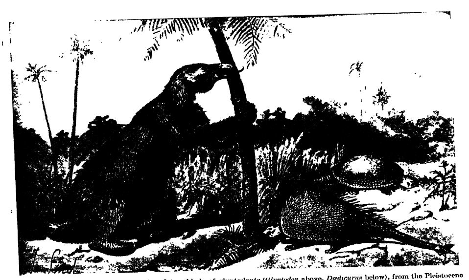
The ground-sloths were represented by a large and widely spread form, Megalonyx, first discovered and named by President Thomas Jefferson. The giant southern form Megatherium (Fig., p. 665), had a body as large as that of an elephant, though shorter in limb, while the oldest and smallest of the sloths was Mylodon.
¶ Collateral Reading
Ernst Antevs, The Recession of the Last Ice Sheet in New England. American Geographical Society, Research Series, No. 11, 1922.
C. E. P. Brooks, The Correlation of the Quaternary Deposits of the British Isles with those of the Continent of Europe. Annual Report of the Smithsonian Institution, for 1917, 1919, pp. 277-375.
O. P. Hat, The Pleistocene of North America and its Vertebrated Animals from the States east of the Mississippi River and from the Canadian Provinces east of longitude 95°, Carnegie Institution of Washington, Publication No. 322, 1923.
Ellsworth Huntington and S. S. Visheb, Climatic Changes. New Haven (Yale University Press), 1922.
R. W. Satles, Seasonal Deposition in Aqueo-glacial Sediments. Memoirs of the Museum of Comparative Zodlogy, Harvard College, Vol. 47, 1919, pp. 1-67.
G. F. Wright, The Ice Age in North America. Sixth edition. Oberlin, Ohio (Bibliotheca Sacra), 1920.
W. B. Wright, The Quaternary Ice Age. London (Macmillan), 1914.