| IV. Evolution, the Constant Change of Living Things | Title page | VI. Seas, the Essential Recorders of Earth History |
[ p. 52 ]
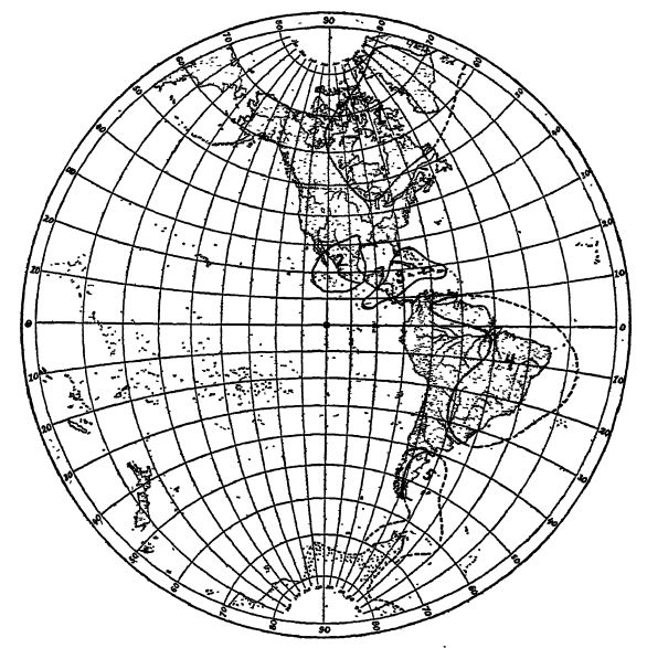
In this chapter we are to study the greater features of the earth’s surface, the continents and oceans, and the interrelations of these parts among themselves and as the abodes of life (see Fig., below).

Major Features of the Earth’s Surface. — The most striking characteristic of the earth’s surface is its division into great land areas, the continents, and into vast oceanic basins. If there were no continents, there would be a universal ocean, and if the earth’s surface had no inequalities of level, the depth of water would be everywhere about 8000 feet. Without land, there would be no terrestrial life, no higher plants than the seaweeds, and among the animals no higher vertebrates at all. The highest mentality of the world would at best be that of the squid or cuttle-fish and crab or lobster. Of sedimentary rocks, there would be almost none. Even the composition of the atmosphere would be of another character, with very little of free oxygen, and the oceans would be devoid of nearly all salt (sodium chloride). This being so, it is a question if life could have originated at all in such a fresh-water environment.
The outer shell of the earth is the rock sphere, in Geology spoken of as the lithosphere. Lying upon the latter, and to a very limited extent circulating within it, is the hydrosphere, or sphere of water; and outside of both is the envelope of gas and vapor known as the atmosphere.
There is an outer rigid portion of the lithosphere that cracks, faults, warps, and folds; it is known as the stratosphere (means composed of layers or strata of rock), or as the tectonosphere (means the shaping outer part of the lithosphere). Below the rigid portion is the very slowly mobile portion of the lithosphere.
Within the hydrosphere, above the surface of the lithosphere, and at the base of the atmosphere exists the biosphere, consisting [ p. 53 ] of the living organisms, the plants and animals. Collectively the organisms are also spoken of as the bios. The biosphere is the transition zone between the atmosphere and hydrosphere on the one side, and the lithosphere on the other. The carbonic acid of the air may be transformed into organic rock through the agency of plant life, and, as coal, take part in the formation of the earth’s crust. Through the life of the waters, carbonic acid and sulphate of lime may be changed to limestone. As carbonic acid results from volcanic action, the hot internal material of the earth may, through plants, become living substances (Walther).
Parts of the Lithosphere. — In its largest features the surface of the earth or lithosphere is divided into lands, the continents (about 30 per cent, or 57,254,000 square miles), and great bodies of salt water, the oceans (about 70 per cent, or 139,295,000 square miles). To the north of the equator occur about three fourths of the total land areas (about 42,000,000 square miles) and these continents are grouped about the small Arctic Ocean. Accordingly the northern hemisphere is also known as the land hemisphere. Over the south pole lies the large continent Antarctica, and surrounding it is the frozen margin of the Antarctic Ocean, whose waters continue with imdefined boimdaries far into the northern hemisphere as the Pacific, Atlantic, and Indian oceans. The Pacific Ocean alone is greater by 10,000,000 square miles than all the lands combined.
In other words, the oceans now surround the six great continents (1) North America; (2) South America; (3) Eurasia, or combined Europe and Asia; (4) Africa, (5) Oceanica or .°quinoctia, comprising West Oceanica or Melanesia, Central Oceanica or Australasia (Australia, Tasmania, New Zealand, and the Fiji Islands), and East Oceanica or Polynesia; and (6) Antarctica (with a probable area, according to Murray, of 5,122,000 square miles).
The relative areas of the lithosphere above and below sea-level are as follows:
The highest peak is Mt. Everest in the Himalayas, 29,141 feet
-
Dry land area 30.4 per cent. Area of continental platform 35.5 per cent
- More than 6000 feet above sea-level . . . 2.3
- Between sea-level and 6000 feet above . . . 28.1
- Between sea-level and 600 feet below . . . 5.1
-
Water area 69.6 per cent. Actual oceanic basins 64.5 per cent
- Between sea-level and 6000 feet below . . . 7.0
- Between 6000 and 12,000 feet below . . . 14.8
- Between 12,000 and 18,000 feet below . . . 39.6
- Between 18,000 and 24.000 feet below . . . 3.1
The greatest known oceanic depth is near Guam, 31,600 feet
[ p. 54 ]
¶ Continents
Mean Elevation of the Land. — The mean height of the continents above the sea is given by Sir Archibald Geikie as about 2400 feet. Dana says that the material of the Pyrenees spread over Emope would raise the surface only 6 feet; and that of the Alps, although of four times larger area, only 22 feet. Finally, only 6 per cent of the lands (or about 3,300,000 square miles) is 3250 feet above sea-level, so trifling is the total surflcial area of the present or visible mountains.
Total Amount of Erosion. — As all of the sodium chloride of the oceans has been derived from the lands through their weathering during the geologic ages, and as the percentage of salt in the average igneous rock is known, we have in these facts a means of computing the amount of such rock worn away in the course of the ages. According to Barrell, this is equivalent to 3.3 times the volume of all lands at present above the level of the sea.
Characteristics of Continents. — Dana defines a continent as “ a body of land so large as to have the typical basin-like form, — that is, independent mountain chains on either side of a low interior.” As the movmtain borders of the continents vary from 500 to 1500 miles in breadth at the base, it follows that a continent cannot be less than a thousand miles (twice 500) in width. The wider border faces the larger ocean; in North America the Pacific Mountains face the Pacific Ocean, while the narrower Appalachians margin the continent on the Atlantic side. Between the latter and the Rocky Mountains lies the continental basin, a vast area drained by the Missouri and Ohio, which flow into the Father of Rivers, the Mississippi. As the Arctic Ocean is small and comparatively shallow. North America and Greenland in the far northeast are bordered by low and narrow mountains, known as the United States Range. On the south, the small Gulf of Mexico has its compensating elevations in the small east-west trending mountains of Arkansas and Oklahoma.
Grain of Continents. — The rocks of the lands usually have a definite strike, or alignment, and this is especially true in the areas of mountains of the present and past. This is the grain of the continents, as seen in the strike, igneous intrusions, rock flowage, schistosity, etc. ; it is due to the various pressures which the continents have undergone during their long history, and to a shrinking earth. It is a fundamental character of all continents and gives hints of their former history and geography. (Ruedemann.)
[ p. 55 ]
Oldest or Nuclear Parts of the Continents. — Most of the present continents have been formed around ancient protuberances of the lithosphere, the nuclear lands, “ the primeval, immovable cornerstones of the earth ” (Emerson). For the most part- these consist of very old igneous rocks and metamorphosed sedimentaries. They are the oldest lands that have remained more or less continuously above sea-level, and it was against these nuclei that many of the mountain chains have been pressed. In general, however, these nuclear continental masses are not the areas from which the formations of the last half of the earth’s history have derived their sediments, for nearly all of them during this time remained low in relation to sea-level. In other words, the sediments have come from the periodically raised moimtains. The nuclei appear to have come [ p. 56 ] into existence before Proterozoic time. The word shield was applied to them by Professor Eduard Suess of Vienna in 1888, because the two best known examples, the Canadian and Baltic masses, have the form of a depressed shield. Nucleus of Dana and Willis is an older and better term. They have also been called cores, bosses, and coigns.
There are at least thirteen of these ancient land masses (see Fig., pp. 55, 57), and to distinguish their names readily from those of the oceans it is proposed in this chapter to accept the method of Arldt, ending the names of the lands in is and those of the oceans and seas in ic. Three of the diields occur in North America: Canadis, Columbis, and Antillis; three in South America: Guianis-Amazonis, and Platis; Africa has Ethiopis and Verdis; Lemuris is peninsular India and Madagascar; the two of Eurasia are Baltis and Angaris; Oceanica has Bornis and Australis; and finally there is Antr ardis, at present a high mountainous ice-covered land, considerable parts of which rise to an altitude of about 10,000 feet above the sea.
Permanency of Continents and Ocean Basins. — In the earlier days of Geology it was held that there was no stability in continents and oceans as such, and that there had been complete interchange between them. Even Sir Charles Lyell taught that all parts of the ocean bottoms had been land. Now, however, most geologists hold with Dana that the oceanic basins and the continents have in the main, although not at all in detail, been permanent features of the lithosphere at least since the close of Archeozoic time. This hypothesis was first announced by Dana in 1849. There is likewise much agreement among geologists in the belief that the oceanic basins are vast sinking fields of heavier materials, also spoken of as the negative areas of the lithosphere, because the sum of their crustal movements is downward; and in general it appears that the oceanic basins have gradually attained not only greater depth but greatly enlarged area as well. On the other hand, the continents are the rising masses of lighter rocks, and for this reason are also called the positive areas, because the sum of their movements is upward (see Pt. I, p. 242). Of the known land surfaces, about one half appear to have the folded structure, but if the younger unfolded rocks were removed, it would be seen that the whole of the continents consist of folded and igneous rocks. Of these two great features of the lithosphere, the oceanic basins are the more permanent, while the continents are either locally enlarged or great masses of them are warped under or fractured and depressed beneath the oceanic level.
[ p. 67 ]
It seems that since Archeozoic time about 25,000,000 square miles of land have gone permanentlj’ beneath the oceans. That the internal forces of the earth have WTought great changes in the outlines of the continents and therefore in the shapes of the oceans as well will be shown in subsequent pages. In general, it may be said that oceans are the most permanent areas and that they have grown larger at the expense of the continents. The contmental masses of the present, day are recognizable in Precambian time, and these early continents occupied much larger areas than their recent descendants” (Ruedemann). The greatest changes have taten place in Oceanica, southern Eurasia, Antarctica toward Australia and South America, and in the central Atlantic and northern Indian oceans.

The proof that there has been no complete interchange between the continents and oceans is seen in the following facts; (1) On the continents there are almost no deposits of deep-sea origin, and the few isolated cases met with occur only on the margins or on continental islands.
Geologists have long sought on the continents for geologic sediments comparable to those now forming in the great abysses of the ocean, but to no avail The German geologist Walther, who has carefully examined recent abyssal sediments, in his geologic studies has considered repeatedly whether any fossil rock possesses abyssal characteristics, and nowhere has he met with such of Paleozoic or Mesozoic age. Sir John Murray also failed to find large areas of oceanic rocks. However, a microscopic and chemical analysis of certain deposits on islands such as Barbados (here 1200 feet above sea-level) and Trinidad of the American mediterranean, Sicily and Malta, Borneo and Timor, and possibly Haiti, Jamaica and Cuba, shows that oceanic deposits of Cenozoic age occur on them. Chamberlin says: “ The cases in which true abysmal deposits now appear above the sea-level do not, when all are put together, appear to attain in area so much as one per cent of the total earth surface. Moreover, nearly all of these oceanic deposits lie in the zones of exceptional crustal instability.”
(2) The marine deposits on the continents are nearly always those of very shallow seas, in fact, not at all unlike those now accumulating on the continental shelves, or in Hudson Bay and the Baltic Sea. Further proof of this is given by the fact that the contained fossils indicate that the life was all of shallow-water types. If there had been complete interchange, on some continent there should be preserved a long and unbroken oceanic record in both the deep-sea sediments and animals, but nowhere has such a series of materials been discovered. (3) It is now established that the lithosphere is denser and therefore heavier beneath the ocean basins than under the lands, making it impossible for them to have interchanged their positions without destroying the density equilibrium of the outer shell.
Deep troughs or geosynclines have, it is true, been repeatedly developed within the continents, near their margins, but even though some of these have in places subsided as much as 70,000 feet, yet at no time have they held other than very shallow seas. This is proved by the character of their sediments and the entombed fossils. Stated in another way, there has been subsidence with compensating sedimentary accumulation. This is certainly true for the Appalachic and Cordilleric geosynclines, out of which [ p. 59 ] there eventually arose the Appalachian and Rocky Mountain systems. See Chapter X.
Two Types of Continental Borders. — Suess, Von Richthofen, and their followers, have pointed out that there are two general types of continental structures. The subsiding Pacific, on the one side, and the Indian and Atlantic oceans on the other have produced distinctly’ different geologic and geographic results. Briefly, the facts are as follows:
The Pacific border areas are usually concordant and follow the trends of the folded mountains bounding this ocean. On the other hand, the Atlantic and Indian border areas are either neutral or are discordant with the structural trend of the coasts.
In general, the rock strata of the Pacific borders are of more recent times, Mesozoic inland and marginally Cenozoic, while those of the Atlantic are oftener of more ancient formations across which discordantly lie the young geologic deposits. Along the Pacific shores there is therefore a parallelism and a readily perceptible dynamic connection with this subsiding ocean, while the marging of the Atlantic and Indian oceans have no such relationship, since the shorelines cut across ancient nuclei, old mountain ranges, and elevated table lands.
Examples of Continental Fragmenting. — As the ocean basins are the more permanent features of the earth’s surface and as they are the periodically sinking areas, it is to be expected that more or less large parts of the ancient continents should have been dragged beneath the waters. In this connection we do not, however, have in mind the mjdJiologic continent Atlantis, since there are no scientific data proving its existence. As a true example of continental fragmenting may be cited Madagascar, a great island, 975 rniles long, with an estimated area of 230,000 square miles, lying in the Indian Ocean off the east coast of Africa. No naturalist doubts its former connection with Affica, because of their sinnilftr animflls, and yet the channel of Mozambique which now separates it from the mainland is from 240 to 600 miles wide, and represents a land area that has gone down to a depth ranging between 5000 and 10,000 feet. To the northeast of Madagascar lie many small islands, the Seychelles, and to the northwest occurs the Comoro group, all of which are also held to have been parts of Africa and Madagascar. Not only this, but many biologists and geologists hold that all of these lands are but parts of the comparatively recent land Lemuris (see Fig., p. 57).
Another striking example is Japan, all of which was a part of the Asiatic continent previous to the Cenozoic, and parts of it remained connected as late as the Miocene. Now the Island Kingdom is separated from the mainland by the Sea of Japan, which is about 600 miles across in its widest part, and over 1000 miles from northeast [ p. 60 ] to southwest. This great downfaulted and sunken field is in general now a shallow sea not much over 650 feet deep, but eastward of the Gulf of Korea there is an overdeepened trough approximately 275 by 325 miles across, having a depth exceeding 10,000 feet.
Africa is unlike most of the continents in that it is a nuclear land, being a series of elevated plateaus ranging between 3000 and 6000 feet, and without marginal folded mountains that are younger than the early Paleozoic. In the northwest of this continent are the Atlas Mountains, actually a part of Europe, and the only ones in Africa of Cenozoic making. Southern Africa retains the roots of very ancient mountains, none of which are younger than Devonian time. Africa is the continent least invaded by the oceans, and its geologic recordings are in the main in continental deposits. It is, in fact, a land of fresh-water and intermontane deposits. The Mesozoic and Cenozoic seas invaded Africa widely only in the north and very sparingly along the east and west coasts. The African continent is a great elevated segment or block of the lithosphere with the geologic appearance of broken-down eastern and western margins. The faulted nature of its coasts is further seen in the fact that they are singularly free of large indentations and harbors. Finally all of eastern Africa, Arabia, and Asia Minor is faulted and rifted m a tremendous way, showing clearly the effects of the inbreaking of the Indian Ocean into greater Africa.
South America, on the contrary, has all along its western coast, in the high Andes, the elevated border required for a continent, but along its east coast we seek in vain for folded mountains younger than the Proterozoic, and it is therefore held by many of the ablest geologists, that northeastern South America across to Africa has gone down into the Atlantic.
Gondwana Land. — The broken-down and submerged parts of the continents referred to above (Africa and South America) are parts of a former great transverse equatorial land, and as there will be occasion to refer to this land from time to time, it is desirable to introduce the subject here.
Besides the facts given above, there is much other evidence of a geologic, paleontologic, and zoologic character relating to the distribution of plants and animals since the Paleozoic, tending to show that Brazil was once widely connected with northwestern Africa across what is now the deep Atlantic Ocean. This lost continent is the Gondwana Land (from a district of the same name in India) of Neumayr (1883) and Suess (1885) and of the zoogeographers, a vast transverse land stretching from the northern half of South [ p. 61 ] America across the Atlantic to Africa and thence across the Indian Ocean to peninsular India, including Lemuris. It was in existence throughout the Paleozoic, but the Atlantic bridge and Lemuris sank into the oceans during the Mesozoic. Gondwana when complete was comparable to another transverse land of the north, Eris or Holarctis, which existed when North America was continuous with Greenland and Eurasia across Iceland to the British Isles (see Figs., pp. 431 and 555).
Mechanics of Continental Fragmenting. — Until recently, geologists have not been able to explain how continental masses may be dragged down or broken up and faulted into the depths of the oceans. The following explanation is by the late Professor Barrell, who was working on this problem at the time of his passing; the evidence is partially presented in The Evolution of the Earth and its Inhabitants, 1918.
In the rift valleys of eastern Africa, Death Valley of southeastern California, and the Caspian Sea of Russia, is seen the evidence of down-fracturing of great inland areas. Of the same nature are the riftings letting in the ocean in the areas of the Red Sea, Gulf of California, and west of Greenland in Davis Strait. From these cases we pass to great horsts like Madagascar, previously described.
To accept the foundering of land masses like those just mentioned, and more especially that of western Gondwana, there must be shown a process of internal loading or weighting of the rocks sufficient to cause them to settle down. It is thought that from 3 to 5 per cent of added weight is sufficient. It is now well known that parts of continents have been made lighter through intrusion of vast granitic bathyliths. The Rocky Mountains area previous to the Miocene tended to remain near sea-level, and since that time has been raised between 6000 and 11,000 feet. There would appear to be evidence here of a regional decrease in density in late geologic time, and the cause appears to be the rising of vast volumes of molten acidic magmas, along with the expansion of the cover rocks caused by the accession of heat, causing the area to rise from one to two miles into isostatic balance.
The specific gravity of igneous rocks varies between 2.70, the average of acidic granites, and 3.30 for the extremely basic types, the pyroxenites and peridotites. Granites have from 65 to 75 per cent of silica, diorites 55 to 65 per cent, and gabbros 45 to 5 per cent. There is here, therefore, a density variation amounting to 20 per cent.
If the earth is layered in density, such heavy masses would presumably originate deeper than those which are more siliceous. The siliceous also give off basic fractions by differentiation, but the exposed intrusives on the continents are mostly granite, and the basic portions represent a smaller volume. Great intrusions of basic magmas rising from the deeper interior would, under the principles of isostasy, produce subsidence.
When the lighter igneous rocks are intruded, they dome the overlying rocks, but in the great intrusions of gabbro at Sudbury, Ontario, the form of the rising mass is saucer-shaped, concave upward. It appears that the floor subsided under it during or after the intrusion, and accordingly also the roofing rocks. This form is the opposite of a laccolith, for the latter make domes. This fimdamental distinction in form appears to be related to the high density. Being [ p. 62 ] denser than the surrounding rocks, such magmas have settled down; Grout has named them lopoliths. The Lake Superior area of gabbro is a far greater lopolith and has given rise to a much larger basin than that of Sudbury. A yet larger area of basic extrusion and intrusion into granitic rocks is that extending from western Greenland across to Iceland and Scotland. In this region, 1800 miles across, occur vast basaltic flows ranging in depth up to 10,000 feet. Their age appears to be Oligocene and early Miocene. Since then, this land of Eris has faulted on a vast scale and broken up into the geography seen to-day.
Another area of similar weighting and downbreaking is that of Lemuris, or the region of the Indian Ocean. Here the evidence is presented by J. W. Gregory in his book. The Rift Valleys and Geology of East Africa, 1922. It is also presented in broad outlines in this book in the chapter on the Upper Cretaceous. Still another is Brazil, described in the chapter on Jurassic time.
¶ Oceans
The Five Oceans. — Oceans are the beginning and end of the rivers of the lands, and the sun furnishes the energy that lifts the waters into circulation. The word ocean is of Greek origin, and came to mean the great outward sea, the Atlantic, as distinguished from the inward sea, the Mediterranean. The ancient peoples of the Mediterranean knew of but one ocean, the Atlantic, that to them surrounded the stationary flat earth. The word ocean now has reference to the connected bodies of marine water that envelop the earth, of which there are five. Pacific, Antarctic, Atlantic, Indian, and Arctic.
Mediterraneans. — The mediterranean waters are also to be considered as oceanic areas, since they are not only large but also very deep, though never so deep as are the deepest parts of the oceans. These seas are, in fact, parts of the oceans, but are long and narrow, and more or less widely enclosed by continents. The typical example is the Mediterranean, lying between Eurasia and Africa; it is also known as the Roman mediterranean, the latter part of the name, meaning a sea in the middle of the land, coming down to us from the ancient nations which once ruled its borders. It figures largely in Historical Geology, and we shall have much to say about it under the name Tethys. Another but less typical example is the American mediterranean lying between the three Americas and walled off from the outer ocean by the Greater and Lesser Antillean islands and South America; it includes the Caribbean Sea and the Gulf of Mexico.
Area. — About 70 per cent of the surface of the earth is covered by oceans, but as the continents are more or less submerged about their edges, these marginal portions down to 600 feet are also truly [ p. 63 ] parts of the continental platforms (Fig., p, 77). Accordingly, the actual oceanic areas occupy somewhat more than 65 per cent of the surface of the earth, or roughly 140,000,000 square English miles.
Arranging the areas according to depth, Murray’s table is as follows;
| Depth in feet | Square English miles | Percentage |
|---|---|---|
| 0- 600 | 9,750,065 | 7.0 |
| 600- 3,000 | 6,964,750 | 5.0 |
| 3,000- 6,000 | 5,010,185 | 3.6 |
| 6,000-12,000 | 26,915 000 | 19.3 |
| 12,000-18,000 | 81,381,000 | 58.45 |
| 18,000-24,000 | 9,058,000 | 6.5 |
| 24,000-31,614 | 216,000 | 0.15 |
| 139,295,000 | 100.00 |
It is very important to bear in mind that nearly 70 per cent of the earth’s surface is covered by water, and hence any marked movement of the earth’s outer shell changes the relation of the shorelines to the lands. Such crustal changes were common throughout the geological ages and were especially effective in causing the oceans to spill widely over the continents, or to retreat and make the lands larger and more protuberant.
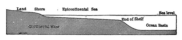
The Continental Shelves. — The continents are more or less submerged about their margins, and the area under water down to the 100-fathom (600 feet) line is truly a part of the continents, because it is only beyond this that the descent is rapid down the continental slopes into the oceanic depressions. For more detail see Fig., above. These marginal shallow-water areas are known as the continental shelves, and have an areal extent of less than 5 per cent (9,750,000 square miles, according to Murray) of the earth’s surface, or 7 per cent of the oceanic areas. Therefore, the continental platforms have an area of less than 35 per cent of the lithosphere, while the remainder, of more than 65 per cent, is occupied by the actual oceanic basins (see Fig., p. 77).
Usually the depth of water over the continental shelves is taken as 100 fathoms, but Daly (1915) states: “ The charts of the world show the break of slope on the shelves to be near the forty fathom line.” Barrell (1915) also takes this view.
The reason why there are continental shelves, and why these are said to terminate at a depth of 600 feet, is because it is at this depth that the ocean storm waves cease to act on the bottoms of the seas. The areas of the continental shelves are, therefore, the regions of agitated waters bordering the lands and capable of holding mud in suspension to depths of not over 600 feet (see Fig., p. 63). The mud-mantled slopes of the ocean basins mark the slow settling of the mud from the waters beyond the reach of wave agitation. Consequently, in all ages the continental shelves must have been constructed at this depth facing the open oceans.
Depth and Volume of Oceans. — Below about 12,000 feet are the submerged oceanic plains with their swells, ridges, and peaks, making up about 65 per cent of the oceanic areas. For more detail, see pages 113-116 of Pt. I of this text-book.
From the above we learn that most of the oceanic areas lie below 6000 feet, and that more than 65 per cent are deeper than 12,000 feet. Areas with a greater depth than 18,000 feet are called deeps, of which fifty-seven are now known (see page 91 of Pt. I). The deeps are of two kinds: (1) the areally greater central deeps that are large, basin-Hke, down-warped regions going to depths of 24,000 feet-; and (2) the more marginal troughs that are long and narrow, going to 31,600 feet. The latter, the foredeeps of Suess, are seemingly down-faulted regions situated near the continents and compensatory to the adjacent uplifted mountains.
The mean depth of the oceans is placed at 13,000 feet, and the volume of all the oceanic waters is said to be fifteen times greater than the mass of land protruding above sesrlevel. If all the deeper parts of the oceans were filled by solid material up to the estimated mean depth, it is said that there would result a universal ocean, covering the entire earth to a depth of 1.5 miles. These facts are recited here not only to impress the student with the immense volume of water when contrasted with the small mass of land above sealevel, but further to show, since the waters are mobile and cover nearly three-fourths of the earth’s unstable surface, why it is that the oceans are enabled so readily to overflow the lands upon relatively small changes in the elevation of the crust. As the oceans are all connected one with another, a movement of the bottom of [ p. 65 ] any one basin affects the oceanic level in all, raising or lowering the strand-line everywhere simultaneously (eustatic movements).
Original Source of Water. — According to the Laplacian theory of earth origin, the ocean waters were regarded as primordial and originating with the primal atmosphere. Following this view, the assumption would be that the original oceans were not only as large in volume as they are now, but even larger, for all of the water in the outer shell of the earth must have soaked into it from the oceans. This theory is no longer acceptable, and it is now held that the ocean waters have been gradually added to the surface of the earth through the volcanoes and thermal springs. In other words, most of the oceanic water was originally water occluded or dissolved in the deep earth, and through volcanic action this juvenile water (steam) has been liberated and added to the already accumulated or vadose water.
Barrell states it as probable that from 25 to 50 per cent of the present oceanic waters have been added during Archeozoic and Proterozoic times, and during the Paleozoic from 5 to 10 per cent more. This therefore means that about 50 per cent of the water present on the surface of the earth had its origin previous to Archeozoic time.
Oceanic Level. — In general practice we speak as if there were a mean sea-level. There is, however, no such condition as a perfect spheroidal oceanic level, or a water surface equidistant throughout each circle of latitude from the center of the earth. Nevertheless, recent researches indicate that the differences of level at different points of the sea-surface do not depart more’ than 100 or 200 feet from a true spheroid of revolution. This subject is discussed further on page 235 of Pt. I under “ datum plane.”
There can not be spread over the entire lithosphere a sheet of water of equal depth, because the earth rotates and is locally heterogeneous in density, is flattened at the poles, and has an uneven surface. Furthermore, the edges of the continents attract the waters upward to them, while the mass of the earth attracts the waters downward. When a great mountain range arises, like the Andes, the water level must rise all along the coast of these mountains, and when these ranges are worn away, then again the water level must sink.
Oceanic Level during the Geologic Ages. — The mean oceamc level in the sense of a flooding plane over the continents has also fluctuated considerably throughout the geologic ages, and the times of these inundations since the beginning of the Paleozoic are now beginning to be deciphered. These, however, [ p. 66 ] are the smaller pulses of the oceanic levels, for there appear also to be longenduring times when the mean of the strand level is either low or high. During the Archeozoic the total of the land areas appears to have been greater than at any other time, and while there were times of wide oceanic flooding during the Proterozoic, yet the continents stood in the main well above the mean of the oceanic level. Toward the close of the Proterozoic, all of the present continents appear to have been completely emergent, since nowhere is there found a marine record until the beginning of the Paleozoic. To emphasize this absence of record, Walcott has named the interval Lipalian time (see Chapter XIII) In the Paleozoic the mean of the oeeanie level was high, but in the Permian it sank and it did not rise again widely over the lands until middle Jurassic time. The fluctuating floods continued to rise well into Cretaceous times, but toward the end of the Mesozoic, the waters subsided. During the Cenozoic, and especially after the Miocene, the continents were mostly emergent, and the climax was in the Pleistocene. The oceans are again tending to submerge the lands.
The cause for such long-persisting changes in the oceanic level is not yet known, but they may be due in minor amount to unloading of the protuberant lands into the oceanic basins, and mostly to the constant increase of the volume of water through the additions from volcanoes. On the other hand, the greater fluctuations have been explained as due to periodic deepening of the oceanic basins, but as they have also become wider through continental fracturing, this twofold volume increase should have made the continents more emergent than they have been. In other words, the oceans seemingly have long had their present mean depth, and the increase in the volume of water has been compensated for by down-sinking parts fragmented from the continents. Continental fragmenting works in cooperation with isostasy to maintain the residual continents above the mean of the oceanic level.
Composition of Ocean Waters. — That the ocean waters are quite salt when contrasted with the fresh waters ” of the rivers and lakes is well known, and the subject has already been discussed on page 91 of Pt. I. The salinity is somewhat variable from place to place, even in the oceans proper, is markedly so along the margins of the oceans where the rivers dilute the sea-water, and is most so in shallow areas under dry climates where concentration may go on continually. The salinity, therefore, may vary from the average of 3.5 per cent and range from less than 1 to over 4 per cent. The composition of the salts is given on the page referred to above.
All of the salts and the nitrogen in the sea as well have been brought down by the rivers, as discussed on pages 45 and 161 of Pt. I. Through the action of organisms the magnesium, Ume, silica, and nitrogen are taken out of the sea-water, while the clays take up the potash, about as fast as supplied; the common salt, however, seems to have increased constantly in quantity.
The great volume of carbon dioxide in the ocean, the main foodstuff for plants, has been absorbed in part from the atmosphere and [ p. 67 ] probably in largest amount from submarine volcanic action during long geologic time. This juvenile CO2 would naturally be retained by the seas. The free oxygen so necessary for animal life has also been absorbed in part from the atmosphere, but the greater amount has come from the carbon dioxide through the action of growing plants. It is thought that nearly all of the free oxygen of the air has been dissociated out of the CO2 by living plants in the oceans and on the lands. The oxygen and CO2 are less abundantly absorbed and retained in the warmer waters of the tropical seas.
Waters rich in calcium carbonate maintam, as a rule, a more varied life than do other waters. Such are especially favorable for organisms that use much lime in their hard parts, e.g., the corals and molluscs; even the crustaceans prefer such waters.
Ocean Currents and Temperature. — The earth rotates on its axis from west to east with a speed, in the equatorial region, of about 1000 miles per hour, while at the poles it becomes nothing. This movement, combined with the effects of the temperature differences of the zones, sets up the well-known trade winds of the tropics that blow rather strongly and constantly toward the equator and to the west, and so drag along the warm tropical surface waters. These in turn impinge on the eastern sides of the continents and are then variously deflected, in the maia according to the shapes of the lands, causing great streams of heated water, or oceanic currents, to flow toward the poles as previously described, pages 92 to 94 of Pt. I. In this way the currents assist not only to equalize the temperature and salinity of the sea water, but also to warm the air in the higher latitudes and to spread the life of the oceans. At the same time the polar waters, receiving but little solar heat and cooled by their great fields of ice, flow equatorward, and since they are heavier than the warm tropical waters, sinlc beneath them into the depths of the oceanic basins. At the surface the temperature varies from about 80° at 5° north latitude (the warmest area) to about 32° at the poles.
Besides the great ocean currents there are many others of varying intensity set up by differences in temperature of the air and water, differences in the pressure of air and water, and varying degrees of salinity, and still others caused by the winds, the waves, and tidal action. The sea is eternally restless.” At the surface the Florida current of the Gulf Stream at its narrowest place, 44 miles, between the Bahamas and Florida, has a mean annual flow of 72 miles per day, but during the warmest and coldest months this rises to 120 miles per day. Northward between the Atlantic States and Bermuda [ p. 05 ] and east of New York the rate of flow is about 48 miles per day. When less than halfway across the Atlantic, the streaming becomes less and less farther northeastward. Prom this rapid and exceptional streaming, the rate of flow or ocean drift ranges down to zero. Around headlands the water may flow as fast as 6 miles per hour. In depth the surface currents penetrate very variably, and in general the stronger currents are near the lands along the continental slopes, oceanic islands, and submerged ridges. As a rule, the penetration is less than 1000 feet, but in the Azores strong currents still exist at 2600 feet. In the tide-swept straits between the Canary Islands currents are present at 12,000 feet, and ofiF the continental slope of Ireland they occur at 6000 feet. Therefore the ocean currents sweep the higher swells and ridges of the bottom clean of ooze, and level the bottoms into monotonous, undulating, abyssal plains.
Dispersion of Life by Currents. — It is a well known fact that nearly all marine animal life begins as minute and usually transparent larvae. These float or feebly swim about for a time, up to several weeks in duration. In this way they may be carried by the great ocean currents many hundreds and even thousands of miles away from where they were born, and into the colder regions of the “ roaring forties ” where they can not maintain themselves because of the polar currents or the reduced temperatures of the winter months. The larvae of West Indian corals are thus carried to Bermuda and have also adapted themselves to the most northerly small reefs off Beaufort, North Carolina. Along the coast of New England are found during the summer months not only larval but as well mature southern foreigners such as jelly-fishes, [ p. 69 ] Physalia (the Portuguese man-of-war), ophiurans, crabs, and other marine types. During the long geologic times when the earth has a nearly uniform mild climate, this oceanic dispersion of life is greatest, and because of these favorable conditions the marine faunas then have a more or less cosmopolitan distribution.
Light Penetration. — Since it is the green plants which assimilate inorganic matter into their living substance, and since animals depend on plants for their subsistence, it becomes necessary to know to what depths the sun’s kinetic energy penetrates into the oceans. Verrill relates that he has dredged red algae two inches tall attached to bowlders at a depth of 480 feet off Eastport, Maine.

White objects can be seen in the clear tropical waters with the unassisted eye down to 200 feet, and coral reefs to 145 feet. Here the sun’s rays enter nearly vertically, but toward the poles the angle is ever more slanting. Therefore, the vertical penetration is much less away from the equator, and at 67° north latitude the bottom can be seen in clear water only down to 80 feet. However, through the aid of photographic plates, it is now established that considerable quantities of light (ultra-violet and blue rays) in the tropical regions go down to 3250 feet, and some even to 5000 feet. These rays, however, are not usable by the assimilating plants
[ p. 70 ]
It is probable that the red, orange, and yellow rays made use of by plants in photosynthesis (i.e., the making of protoplasm through light energy) do not go in depth much beyond 600 feet. The portion of the ocean penetrated by sunlight is, therefore, spoken of as the diaphanous region, or the zone of transparency. It is also the region of photosynthesis, where the green plants change inorganic substances into organic structures. The dark region, where plants do not live, is known as the aphotic region, or the zone where sunlight is absent.
Oceanic Muds and Oozes. — The continental edge is also the mudrline, for everywhere over the ocean bottoms only fine-grained mud is being deposited; on the continental slopes, green and blue muds, coral mud, and volcanic ash of coarser grain (see p. 113 of Pt. I, and Fig., p. 71 of Pt. II); and elsewhere, green, blue, and red oozes of the finest grain. The mud of the continental slopes is [ p. 71 ] [ p. 72 ] mostly derived from the continents and is carried seaward by the action of the waves and the currents; while the impalpably fine oozes of the oceanic abysses are largely of organic origin and mainly result from the microscopic floating forms of plants and animals that live in the upper sunlit waters, and upon their death rain into the deeps, where their soft parts are food for the life of the bottom, and their skeletons go to make up the muds of the deep seas (see Figs., p. 115 of Pt. I, and pp. 68-70 of Pt. II). Wind-borne volcanic and desert dust and the disintegrated floating pumice are also contributed, however, and become notable in the composition of the red clays which floor the deepest parts of the ocean basins.
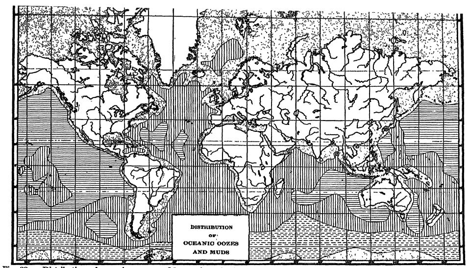
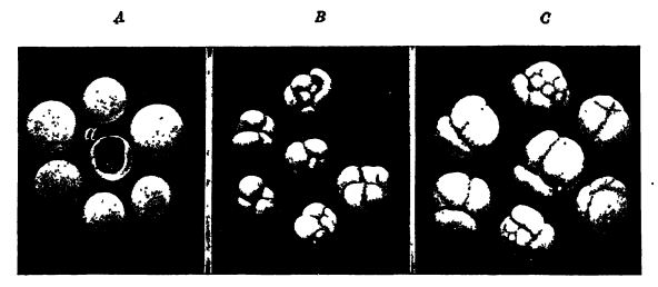
Globigerina Ooze. — Globigerina ooze is a fine organic mud- with more than 30 per cent of calcium carbonate, derived in the main from the tests of the microscopic animals known as Foraminifera, of which Globigerina and Orbulina are the most prevalent forms (Fig., p. 68). These animals, of which there are about twenty kinds in tropical regions, live in the sunlit waters and after their death drop into the abyss. To them in the warmest waters are added other microscopic calcareous particles derived from lime-secreting algae (coccospheres and rhabdospheres, Figs. 4-5, p. 154). This type of ooze is more widely distributed than any other, and usually occurs in depths of less than 15,000 feet and more than 6000 feet, although around tropical oceanic islands it may form in the shallowest of seas. On the one side the Globigerina ooze merges into the blue muds and on the other into the red clay, for at greater depths than 15,000 feet the solvent powers of the abyssal waters, as previously stated, dissolve the lime and carry it away in solution. The Globigerina oozes originate in the warmer waters and occupy nearly 30 per cent of the ocean bottoms (Fig., p. 71).
Diatom Ooze. — In the surface waters of the oceans also live microscopic plants that secrete beautifully ornamented siliceous tests, and of these a single species is particularly abundant in the polar waters (Fig., p. 69). Their tests after death fall into the deeps and there form the Diatom ooze, which occupies about 6.5 per cent of the oceans in high latitudes (Fig., p. 71). See also page 115 of Pt. I.
Radiolarian Ooze. — The Radiolaria are microscopic animals that also secrete very beautifully shaped and ornate tests of silica (Fig., p. 70); while they occur in all oceans they are most abundant and varied in the tropical regions of the Pacific and Indian oceans. The area of these oozes is small, being about 3.4 per cent of the oceans. Murray states that the Radiolarian ooze may be regarded as a variety of red clay containing many radiolarian skeletons (Fig., p. 71).
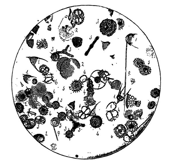
The Living Plankton. — The life feature of prime importance in the ocean is the plankton, a term that Haeckel proposed for the passively floating life of the seas, a world of little things, which is also a part of the pelagic life. It may be gathered in a very fine meshed net, and when so taken appears as a variously colored gelatinous film having a fishy smell. The great majority of the plankton is made up of primitive plants (mainly algae, Fig., p. 69, and Figs. 4, 5, p. 154) and animals (chiefly Foraminifera and Radiolaria, [ p. 73 ] Figs., pp. 68 and 70, and, at certain seasons, the larvae of higher animals) that are microscopic in size. It is a wonderfully interesting micro-flora and -fauna, a well adjusted society of organisms with its producing class of synthetic plant forms, and its consuming class of animals. It is seK-sustaining and independent of the land other than for chemical and mineral foods. It has been described as “ the pastures of the sea ” and compared with “ the grass of the fields.” The quantity and variety change from place to place and with the season of the year, being far more abundant close to the lands and in temperate waters than out in the open ocean and in polar seas.
The plankton lives and propagates mainly in the upper 300 feet of the oceans. It is the cause of most of the phosphorescence seen glowing at night, for much of it then rises to the surface. “ There is a cascade of sparks at the prow, a stream of sparks all along the water-level, a welter of sparks in the wake, and even where the waves break there is fire. So it goes on for miles and hours, and is just one of a thousand wa 3 rs of feehng the abundance of life” (Thomson). The plankton is also the food for most of the animals living on the bottom of the oceans, which are collectively known as the benthos, and all animals that swim freely about are dependent for sustenance upon it. In other words, the plankton is the ultimate source of food for all marine animals.
The plankton directly figures but little in Geology because of its very perishable nature. Indirectly, it makes important contributions by adding carbon to the black muds.
Life of the Cold Abyssal Waters. — The waters at the bottom over the abyssal plains are everywhere dark, icy cold, and almost without movement. In addition, the pressure is great, the oxygen is scarce, and as there are no barriers the highly specialized animal life, in the main invertebrates, has migrated quite uniformly, though sparingly, over the bottoms. The sparse fauna consists mostly of blind forms, and where eyes have been inherited and are still functional, as in some fishes, they are enlarged to great size that they may catch any ray of light, for nearly all abyssal invertebrates and fishes are phosphorescent, thus being able to “ transform the dark depths into a magic garden.” In some of the fishes the entire body glows, in others there are rows of minute sparkling spots on the ades of the body, or there are hashing lights on the head, or at the ends of long tentacles. Others have long delicate feelers for finding their way along the bottoms of the dark abysses.
[ p. 74 ]
¶ Collateral Reading
James Johnstone, Conditions of Life in the Sea. Cambridge (University Press), 1908.
Otto Keummel, Handbuch der Oceanographic. Two volumes. Stuttgart (Engelhom), 1907 and 1911.
John Murray and Johan Hjort, The Depths of the Ocean. London (Macmillan), 1912.
Eudolph Ruedemann, The Existence and Configuration of Precambrian Continents. New York State Museum, Bulletin 239-240, 1922, pp. 65-152.
A. Agassiz, A Contribution to American Thalassography. Three cruises of the U. S. Coast and Geodetic Survey Steamer Blake in the Gulf of Mexico, in the Caribbean Sea, and along the Atlantic Coast of the United States from 1877 to 1880. Bulletin of the Museum of Comparative Zoology, Harvard College, Vols. 14 and 15, 1888.
C. Wyville Thomson, The Voyage of the Challenger. Two vols. New York (Harper), 1878.
J. Walther, Allgemeine Meereskunde. Leipzig (Weber), 1893.
| IV. Evolution, the Constant Change of Living Things | Title page | VI. Seas, the Essential Recorders of Earth History |