Public domain
[p. 846]
The distinguishing feature of this period is its extensive glaciation, ice-sheets covering six or eight million square miles of the earth’s surface where mild climates had prevailed not long before. But for the ice-sheets and their effects, this period might properly be joined to the Pliocene, making one period of high and extensive lands and correspondingly restricted oceans.
¶ General Distribution of Glaciation
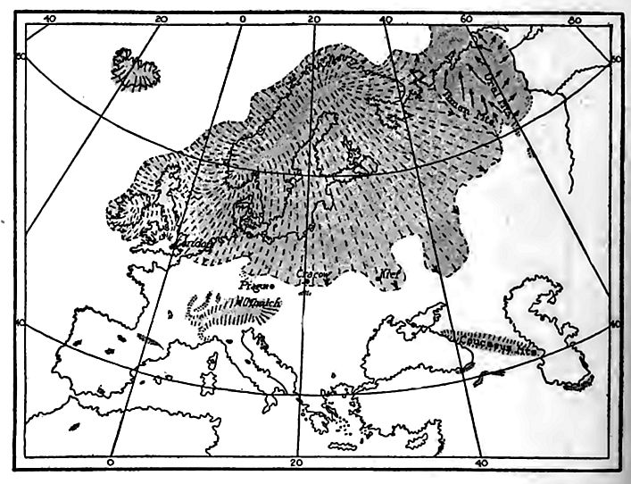
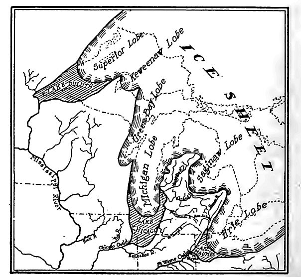
More than half the area glaciated during the Pleistocene period was in North America (Fig. 560), and more than half of the remainder in Europe (Fig. 561). The glaciation was, therefore, notably localized, though the whole world felt its effects.
North America. Nearly half of North America was buried by ice (Fig. 560), and strangely enough, it was the northeastern half of the continent rather than the northern. More strangely still it was the plain, rather than the mountainous part, which had most ice. Alaska was largely free from ice except in the mountains, and continuous glaciation did not extend as far south on the mountain-girt plateaus of the Pacific border as on the smooth low plains of the Mississippi basin.
Three great centers of ice radiation, besides Greenland, have been recognized.[1] These are the Labradorean, the Keewatin, and the Cordilleran. From these centers, ice-sheets spread, covering some 4,000,000 square miles. The centers from which the movements radiated are determined with certainty by glacial striae, and by the direction of transportation of drift.[2]
From the Labradorean center, the extension was notably [p. 847] greatest to the southwest, and in this direction the limit is some 1,600 miles from the center of dispersion, in latitude about 37° 30’, the most southerly point of the great lowland glaciation of the period. The extension of the Keewatin ice-sheet to the southward was scarcely less. It found its limit in Kansas and Missouri, about 1,500 miles from its center, while to the west and southwest it reached 800 to 1,000 miles toward the Rocky Mountains. One of [p. 848] the most marvelous features of the ice dispersion was the gnat extension of the Keewatin sheet from a low flat center westward and southwestward over what is now a semi-arid plain, rising in the direction in which the ice moved, while mountain glaciers on the west, where now known, pushed eastward but little beyond the foothills.
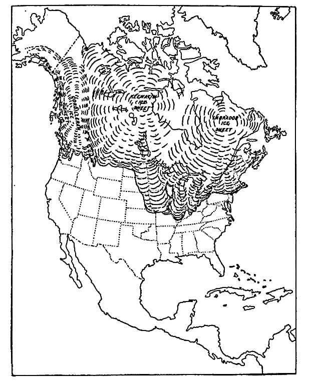
The Cordilleran ice-sheet is less simply defined. Much of it occupied a plateau hemmed in by mountains, and plateau glaciation was complicated by extensive mountain glaciation of alpine type. In some sense, the whole Cordilleran ice-sheet was the product of a confluence of mountain glaciers deploying on the intervening plateau; but there appears to have been plateau glaciation not solely dependent on contributions of ice from the mountains. The southerly lobes of the complex body of ice crossed the boundary of Canada into the United States. Though hampered by its environment, [p. 849] the Cordilleran ice-sheet seems to have conformed to the habit of the Labradorean and Keewatin sheets in expanding chiefly to windward. The plains of Alaska seem to have been largely free from glaciation even when the waters of the Ohio and the Missouri, 2,000 miles farther south, were being turned from their courses by the ice-sheets. The localization of the glaciation is one of its most significant features.
South of the more or less continuous Cordilleran glaciation of Canada, local glaciers were widely distributed in the western mountains, even down to New Mexico, Arizona, and southern California. They were larger at the north and smaller at the south. Of glaciation in the mountains of Mexico little is known.
Greenland was glaciated somewhat more extensively than now, but its glaciers appear never to have extended to the continent, as was formerly conjectured. Newfoundland seems to have had its own ice-sheet, and the same was probably true of Nova Scotia, and perhaps of the peninsula between the Bay of Fundy and the lower St. Lawrence.
Other continents. South of the ice-sheets of Europe, great glaciers descended from the Alps to the lowlands in all directions, and lesser ones among the lower mountains. Iceland was buried in ice, and even Corsica had glaciers. In Asia glaciers larger than those of to-day affected all the higher mountains, and ice-sheets existed in some of the more northern lands. The southern hemisphere was affected to a lesser degree, but the higher mountains generally bore glaciers, and Antarctica is assumed to have been buried beneath ice as now. In tropical regions, there were glaciers in mountains where none exist now, and in mountains where there are glaciers, the ice descended then to levels 5,000 feet or more below its present limits.
¶ The Criteria of Glaciation
The area of North America which was overspread by ice is covered by a mantle of clay, sand, and bowlders, which taken together, constitute the drift. The various lines of evidence which have led to the general acceptance of the glacial theory, have to do with (1) the drift, (2) the surface of the rock which underlies [p. 850] it, and (3) the relations of the drift to its bed. Some of the principal considerations are the following:[3]
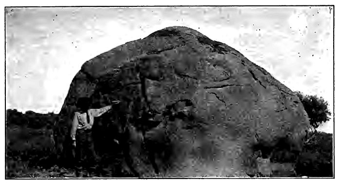
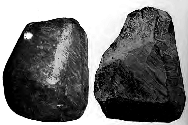
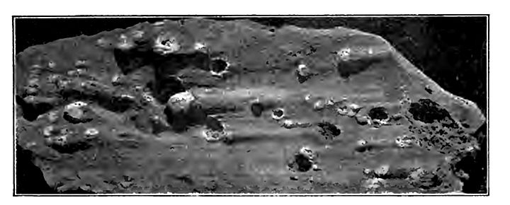
1. The constitution of the drift. One of the striking characteristics of the drift is its heterogeneity, both physical and lithological. It is made up at one extreme, of huge bowlders (Fig. 562), and at the other of impalpable earthy matter. Between these extremes there are materials of all sizes, and the proportions of coarse and fine are subject to the greatest variations. Coarse materials are, on the whole, most abundant in regions of rough topography, where the underlying and neighboring formations in the direction from which the drift came are resistant; fine materials [p. 851] are most abundant where the underlying formations and neighboring formations in the direction from which the drift came are weak. The fine part of the drift is made up chiefly of the same materials as the gravel and bowlders, but of these materials in a fine state of subdivision. The coarse and the fine materials are often mixed without trace of assortment or arrangement.
The drift of any locality is likely to contain rock material from every formation over which the ice which reached that locality had passed; but the larger part of the drift of any place is of materials from formations near at hand. Probably 75% of the material of the drift was not moved 50 miles.[4] No agent except glacial ice can impress these precise features on the deposits which it makes.
2. Peculiarities of the bowlders, etc., of the drift. The bowlders and smaller stones of unstratified drift possess significant features. Many of them have smooth surfaces, but they are not generally rounded. They are often sub angular, and the wear which they have suffered has been effected obviously by planning and bruising, rather than by rolling (Figs. 205 and 564). Some of these planed, subangular bowlders and stones are distinctly marked with [p. 852] one or more series of lines or striae on one or more of their faces. The lines of each series are parallel, but those of different sets may cross at any angle. By no means all the stones of the drift show striae. They are rarely seen on those which have lain long at the surface, and they are more common on the less resistant sorts of rock, such as limestone, than on more resistant ones, such as quartzite. No depositing agent except glaciers habitually marks the stones which it deposits in this way.
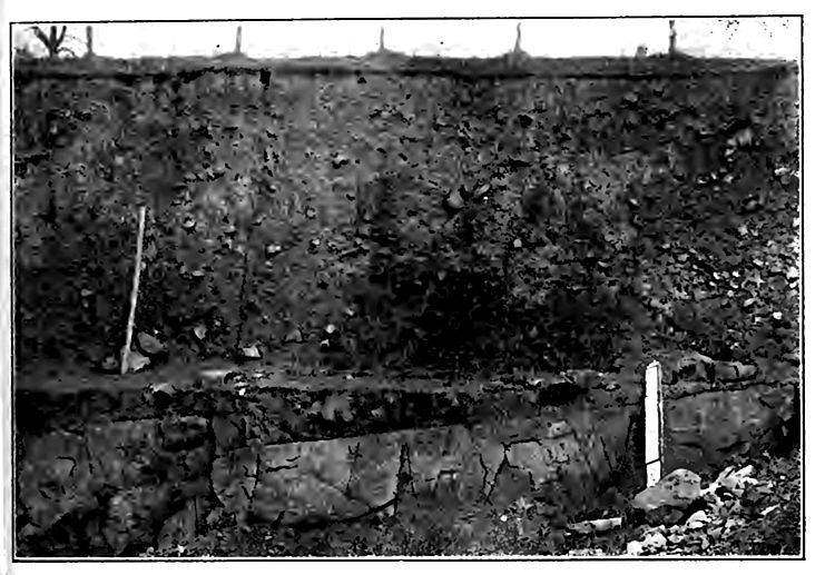
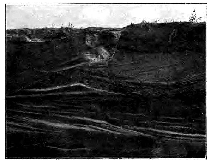
3. Structure. The larger part of the drift is unstratified, hut a considerable part is stratified, often irregularly. The unstratified drift (Fig. 565) or till (for some of it the name bowlder-clay is appropriate), has little orderly arrangement of its parts, yet it often has a sort of rude cleavage which has been called foliation (Fig. 566). The planes of cleavage are in such position as to suggest that they were developed by pressure from above. The stratified drift (Fig. 567) shows by its structure that it was deposited by water, which doubtless sprang, in large part, from the melting of the ice.
[p. 853]
Either of the two great types of drift, the stratified and the unstratified, may overlie the other, or the two may be interbedded. The association of the two is often such as to demonstrate their essential contemporaneity of origin. No agents but glacial ice and glacio-fluvial waters could have brought about such relations between the stratified and unstratified drift over such extensive areas.
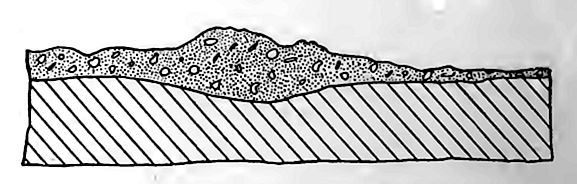
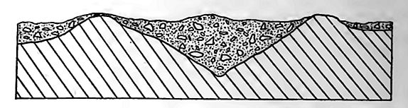
4. Distribution. The distribution of the drift is essentially the same as that of the ice-sheets and glacial waters; but apart from this general fact, there are several special features to be noted, (a) Within the area of its occurrence, the drift is measurably independent of topography. That is, its vertical range is as great as the relief of the surface itself. Within the state of New York, for example, it ranges from sea-level to the tops of the Adirondacks, nearly 5,000 feet above. It is found in valleys and on hills, and [p. 854] on plains, plateaus, and mountains, indiscriminately, though not usually in equal amounts, (b) The drift is sometimes so disposed as to make the surface rougher than it would be otherwise, and sometimes so as to give it less relief. This is illustrated by Figs. 568 and 569. © It is measurably independent of present drainage basins, so far as its constitution is concerned. Thus, materials from one drainage basin are found in the drift of other drainage basins so commonly as to make it clear that present divides did not constitute divides to the ice. (d) Various sorts of material in the drift at certain points are so related to their sources as to make it clear that they were carried upwards, sometimes hundreds of feet, from their original sites, (e) A considerable area in southwestern Wisconsin, and the adjacent parts of Illinois, Iowa, and Minnesota without drift. This driftless area is neither notably higher nor lower than its surroundings, and glacial ice seems to be the only[p. 855] agent which could have spared it, while covering its surroundings, (f) Stratified drift often extends beyond the unstratified in the direction in which the ice was moving, especially in valleys and on low land. This is the work of running water.
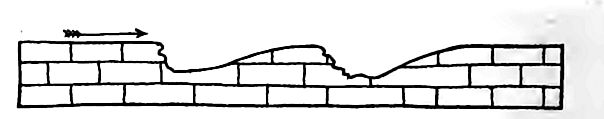
5. Topography. Among the characteristic features of the topography of the drift are: (a) Depressions without outlets, and (b) associated knobs, hills, and ridges, similar in size to the depressions (Figs. 227 and 570). Many of the depressions contain ponds or lakes. The surface of some parts of the drift, on the other hand, is nearly plane. Neither planeness nor unevenness can be ascribed exclusively to the stratified nor to the unstratified drift. Either may be rolling, or either may be plane, though the phases of topography assumed by the two sorts of drift are somewhat unlike.
6. Thickness. The drift ranges from zero to more than 500 feet in thickness, and the variations are often great within short [p. 856] distances. Within the glaciated area, one hill may be composed of drift, while the next has only an interrupted veneer of it. The drift may be thick on hills and thin in valleys, or, more commonly, the reverse. No agent besides glaciers habitually leaves its deposits so unequally distributed, and in such disregard of pre-existing topography.
7. Contact with underlying rock. The plane of contact between the drift and the rock beneath is generally, though not always, sharply defined, and the surface of the rock is likely to be fresh and firm (Figs. 203, p. 252). This relation is in contrast with that between the mantle rock and the underlying formations where there is no drift (Figs. 210, p. 257).
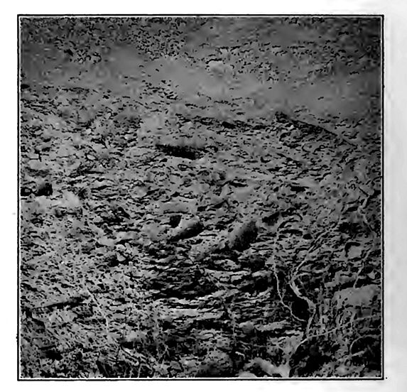
8. Striation and planation.[5] The rock surface beneath the drift, and especially beneath the unstratified drift, is frequently polished, planed, striated (Fig. 203), and grooved. These features are wide-spread throughout the drift-covered area, and they occur at all elevations where the drift occurs. The striae on the bed rock beneath the drift are generally approximately parallel in any given [p. 857] locality, and tolerably constant in direction over considerable areas. When large areas are considered, the striae are sometimes far from parallel; but their. departure from parallelism is generally according to a definite system (Fig. 571). The direction of striae corresponds with the- direction in which the drift was transported.
Besides the striae, grooves, etc., on the bed rock, there are often other details of surface which are equally characteristic. Minute protuberances of surface often show more wear on one side than on the other (Fig. 572), and minute depressions (Fig. 573) show analogous features.
9. The shapes of rock hills. The rock knolls which were left bare when the ice retreated often show peculiarities of form and surface which are distinctive. Like the minute protuberances of surface just referred to, rock hills over which the ice passed were worn more on the side from which the ice approached (the stoss side) than on the other (Fig. 211, p. 257). Bosses of rock which do not show notably unequal wear often show distinct smoothing. Projecting glaciated knolls of rock which show the characters seen in Fig. 225, p. 269 are known as roches moutonnées. A succession of roches moutonnees generally gives fairly accurate information [p. 858] as to the direction of ice movement, even though striae are not preserved.
Summary. The characteristics of the drift, as set forth in the preceding paragraphs, leave little room for random speculation concerning its origin. From its variable thickness we know that the force or forces which produced it must have been such as could leave the drift now in thick bodies and now in thin, over either limited or [p. 859] extensive areas. From its distribution we know that the force or forces which produced it were largely independent both of underlying rock formations and of topography. From its physical make up we know that the agency or agencies which produced it must have been able to carry and deposit, at one place and at one time, materials as fine as the finest silt or mud, and bowlders many tons in weight, while they were competent, under other circumstances, to make deposits of much less extreme diversity. From its lithological make up, and from the nature of the finer parts of the drift, we know that the drift forces worked on different sorts of rock, deriving materials from many; that they ground some of the materials into a fine earthy powder or “rock flour,” commonly calledclay; that they as a rule derived the larger part of the drift of any locality from formations near at hand; and that the materials, even large bowlders, were sometimes carried up to altitudes considerably above their source. From the structure of the drift it is concluded that the drift force or forces must have been capable of producing deposits which were sometimes stratified and sometimes unstratified, and that the deposition of these two phases of drift was sometimes contemporaneous and sometimes successive, the number of alternations being considerable in some places. From the striae on the stones of the drift it is known that the production of the drift must have involved the action of forces which, under some conditions, [p. 860] were capable of planing and beveling and striatiiig many stones, especially the softer ones of the unstratified drift, while rounding and leaving unstriated most of those of the stratified; but that the agency or agencies concerned must have been such that under certain circumstances their activities failed, on the one hand, to leave more than a very small percentage of the stones of the unstratified drift beveled and striated, while, on the other hand, they sometimes permitted the stratification of gravels containing many sub-angular, plane-faced, and striated stones, varying in size from pebbles to bowlders. From the striae on the bed-rock beneath the drift and the unweathered character of the surface of the rock, it is clear that severe wear was inflicted on the surfaces over which the drift was spread, while the positions in which the strise were developed show that the agency which inflicted the wear was able to adapt itself to all sorts of surfaces. The general parallelism of strise in a limited area, and the systematic departure from parallelism over great areas, are also significant of the manner in which they were produced. From the topography of the drift it is known that the forces which produced it must have been such as were able to develop plane surfaces at some points, surfaces marked by more or less symmetrical drift-hills, which are measurably independent of rock-topography at others, and short, choppy hills, associated with undrained depressions, in still others.
The true theory of the drift must explain all these facts and relations. Any hypothesis which fails to explain them all must be incomplete at the least, and any hypothesis with which these facts and relations are inconsistent, must be false.
Geologists are now very generally agreed that glacier ice. supplemented by those other agencies which glacier ice calls into being, is the only agent which could have produced the drift. But it is [p. 861] not to be forgotten that this does not preclude the belief that at various times and places, in the course of the ice period, icebergs may have been formed, or that locally and temporarily they played an important role. It does not preclude the idea that, contemporaneously with the production of the great body of the drift by glacier ice, the sea may have been at work on some parts of the present land area, modifying the deposits made by ice and ice drainage. Indeed, there is abundant evidence that such was the fact, for some regions, now covered by drift, stood lower than now, relative to sea level, when the drift was deposited, or since. The glacial theory does not deny that rivers produced by the melting of the ice were an important factor in transporting and depositing drift, bo.th within and without the ice-covered territory. It does not deny that lakes formed in one way and another through the influence of ice, were locally important in determining the character and disposition of the drift. Not only does the glacier theory deny none of these things, but it distinctly affirms that rivers, lakes, the sea, icebergs, and pan-ice must have co-operated with glacier ice in the production of the drift, each in its appropriate way and measure, and that after the disappearance of the ice and the ice-water, the wind had some effect on the drift before it was clothed with vegetation.
¶ The Development and the Thickness of the Ice-sheets
The development of glaciers from snow-fields has been discussed already (p. 229), but a few words with reference especially to the development of the ice-sheets of our continent, are here added.
If the expansion of the ice-sheets was due principally to movement from a center or centers, the ice at these centers must have been prodigiously thick, for in the course of its progress it encountered and passed over hills, and even mountains, of considerable height. In the vicinity of elevations which it covered, its thickness must have been at least as great as the height of these elevations above their bases.
If the centers of the North American ice-sheets remained the centers of movement throughout the glacial period, and if the degree of surface slope necessary for movement were known, the maximum [p. 862] thickness of the ice could be calculated. It is probable, however, that the centers of the ice-sheet did not remain the effective centers of movement, and that the surface slope necessary for movement was variable.
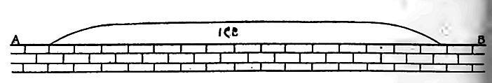
If the fall of snow toward the margin of the ice-sheet greatly exceeded that at its center, as it probably did, a belt near the margin, rather than the geographic center of the field, may have controlled the marginal movement of the ice. With excess of accumulation near the border, the slope of the surface near the edge might be relatively great, while it was slight, or even nil in the center of the field, as shown by Fig. 574. Under these circumstances, the maximum thickness of the ice-sheets might be notably less than if the geographic center remained the effective dynamic center. The former view is illustrated by Fig. 574.
No sufficient data are at hand for determining with accuracy the average slope of such an ice-sheet as that which covered our continent, but something is known of its slope at certain points. Near Baraboo, Wis.,[6] the edge of the ice at the time of its maximum extension in that region lay along the side of a bold ridge, the axis of which was nearly parallel to the direction of ice movement. The position of the upper edge of the ice against the slope of the rii is sharply defined. For the last % miles, its average slope about 320 feet per mile. This was at the extreme edge of the ice, where the slope was at a maximum. In Montana, the slope of upper surface of the ice for the 25 miles back from its edge has been estimated at 50 feet per mile.[7] Half of this seems like a very lowslope. A surface with a slope of 25 feet per mile would Seem to the [p. 863] eye to be nearly plane; yet even so moderate a slope may lead to very extraordinary conclusions.
The southern limit of drift in Illinois is not less than 1,500 or 1,600 miles from the center of movement. An average slope of 25 feet per mile for 1,600 miles would give the ice a thickness of 40,000 feet at the center, the slope of the surface on which the ice rested being disregarded. This thickness, nearly eight miles, seems incredible. Even an average slope of 10 feet per mile would give a thickness of about three miles at the center. If by reason of relatively great precipitation near its margins, the only part of the ice-cap which had any considerable slope was its outer border (Fig. 574), so great a maximum thickness would not be demanded.
Stages in the history of an ice-sheet. The history of an icesheet which no longer exists involves two distinct stages. These are (1) the period of growth, and (2) the period of decadence. If the latter did not begin as soon as the former was completed, an intervening stage, representing the period of maximum ice extension is to be recognized. In the case of the ice-sheets of the glacial period, each of these stages was probably more or less complex, the general period of growth being marked by temporary intervals of decadence, while during the general period of decadence the ice was subject to temporary intervals of growth. In the study of the work accomplished by an ice-sheet, it is of importance to distinguish between these main stages.
¶ The Work of an Ice-sheet
Erosion and deposition were the two great phases of ice work, and both have been discussed briefly (pp. 251-68). It may be noted here that the surface over which the ice-sheets moved probably had an erosion topography, and was covered by a layer of mantle rock. The ice removed the mantle of decayed material, and cut deeply into the undecayed rock beneath. By its erosion, the ice modified the topography to some extent, for weaker formations were eroded more than resistant ones, the topography favored more forcible abrasion at some points than at others, and the ice itself [p. 864] was more effective at some times and places than at others. On the whole, the topographic effect of glacial erosion was probably to soften the surface contours, without noticeably diminishing the relief.
The second great result of the ice-sheets was the deposition of the drift. Some of it was deposited while the ice-sheets were growing, some of it after they had attained their growth, and some of it while they were declining. Some of it was deposited beneath the body of the ice, and some of it at its edge. The drift altered the topography notably, especially where it was thick and the relief of the underlying rock slight.
Formations Made by the Ice-sheets[8]
The drift formations fall chiefly into three categories, namely (1) those made directly by the ice (unst rati fled), (2) those made [p. 865] by ice and water conjointly (stratified, but stratification often irregular), and (3) those made by water emanating from the ice (stratified, often with cross-bedding).
Ground moraines, terminal moraines, and lateral moraines are the principal types of drift deposited by glaciers directly. So far as ice-sheets are concerned, ground moraines are the most extensive by far, and lateral moraines have little development.
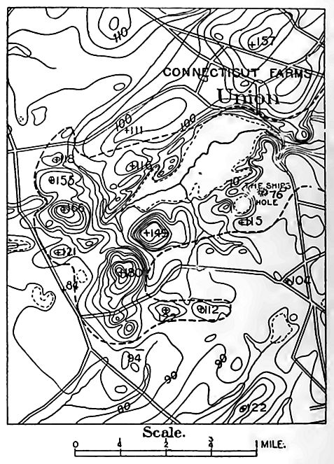
The characteristics of the ground moraine are those usually given for drift in general. Ground moraine (or till) is nearly coextensive with the ice-sheets themselves, though it failed of deposition in some places, and has been removed in others. The ground moraine of the North American ice-sheets is thickest in a broad belt a little within the margin of the drift (Fig. 560), extending from central New York through Ohio, Indiana, Illinois, Iowa, Minnesota, and Dakota, and thence northward to an unknown limit in Canada.
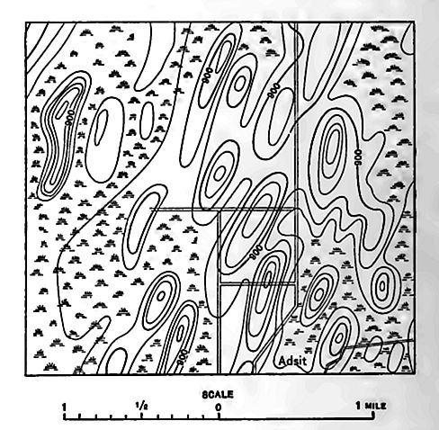
The topography of the ground moraine varies within wide limits. It is commonly undulatory, involving gentle swells and sags (northeast half of Fig. 228). In some cases the swells take on rather definite elongate shapes, with their longer axis in the direction of ice movement. They are then called drumlins (Fig. 575). Drumlins have pronounced development in eastern Wisconsin, where they are numbered by the thousand, in central and western New [p. 866] York, in some parts of New England,[9] and in some other places. The drumlins of New York (Fig. 577) are, in general, longer and narrower than those of Wisconsin.
The origin of drumlins has been much discussed without reaching a final conclusion. Opinion is chiefly divided between the views (1) that they were accumulated beneath the ice under special conditions, and (2) that they were developed by the erosion (by the ice) of earlier aggregations of drift.2
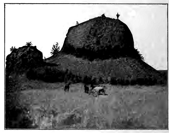
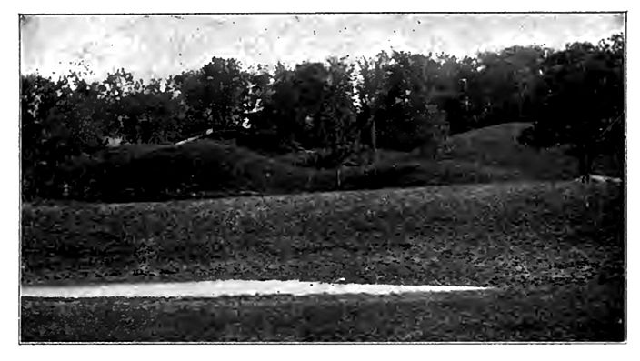
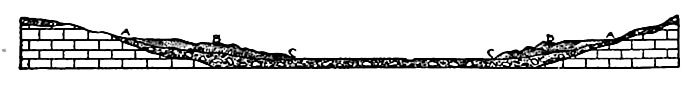
A terminal moraine is made where the edge of the ice remains nearly stationary in position for a considerable period of time. In constitution, it may be very like the adjacent ground moraine, though there is often a larger proportion of stratified drift associated with it. It sometimes constitutes a more or less well-defined ridge, but it is more accurately characterized as a belt of thick drift. Its most distinctive feature does not lie in its importance as a topographic feature, but in the details of its own topography. Its surface is often characterized by hillocks and hollows, or by interrupted ridges and troughs, following one another in rapid succession, and without apparent order (Figs. 227, Figs. 228, and 570). Many of the hollows and troughs contain marshes, ponds, and lakes. The shape and abundance of round and roundish hills, and of short and more or less serpentine ridges, often closely huddled together, have locally given rise to such descriptive names as “knobs.” “short hills,” etc.; but it is the association of “knobs” or “short hills” with “kettles,” and not either feature alone, which is especially characteristic of terminal moraine topography.
The “knobs” vary in size, from low mounds but a few across, to considerable hills half a mile or more in diameter, and a [p. 867] hundred feet or more in height. Not rarely they are about as steep as the loose material of which they are composed will lie. The “kettles” are the counterparts of the elevations. They may be a few feet, or many rods, or even furlongs in diameter. They may be so shallow that the sagging at the center is scarcely observable, or they may be scores of feet in depth. Where steep-sided depressions are closely associated with abrupt hillocks, the topography [p. 868] may be notably rough. The topography of the terminal moraine may be well developed, even where the moraine as a whole does not constitute much of a ridge.[10]
The surface of the terminal moraine, where well developed, is generally rougher than that of the ground moraine, but more hecause the sags and swells are of smaller area and steeper slopes than because the relief is notably more. It is not to be understood, however, that this peculiar topography always affects terminal moraines, or that it is confined strictly to them. The elevations and depressions of the moraine may grade from strength to weakness, and locally may even disappear, while features closely simulating those characteristic of terminal moraines are sometime! found in other parts of the drift.
Where an ice-sheet halted in its retreat, its edge remaining in a [p. 869] constant or nearly constant position for a sufficiently long period, a terminal moraine (called a recessional moraine) was developed. The not uncommon impression that a terminal moraine is one which marks the terminus of the drift, is erroneous. The word terminal refers to the terminus of the ice at the time when it formed the moraine.
Fluvio-glacial Deposits
The waters arising from the melting of the ice-sheets organized themselves to a greater or less extent into streams before they left the ice.[11] Ultimately, the subglacial and englacial waters escaped from the ice, and when this took place, the conditions of flow were changed more or less suddenly, and deposits were made in several classes of situations.
1. At the edge of the ice. Where subglacial streams flowed under “head,” the pressure was relieved when they escaped from the ice, and decrease of velocity and deposition of load were the common results. In many cases, the deposits were made at the edge of the ice. After the ice melted, the deposits which had [p. 870] been made against it and on its edge sometimes assumed the form of mounds, hillocks, and short ridges, known as kames (Fig. 580). Karnes are primarily phenomena of the margin of the ice, developed by running water (the active agent) in association with ice (the passive partner). Kames are composed of stratified gravel and sand chiefly, but the stratification is often very irregular, and the gravel ill-rounded. In position, kames have some relation to terminal moraines, and many of the conspicuous knobs and lulls of such moraines are, individually, kames.
In regions of strong relief, ice often occupied deep valleys after it disappeared from the intervening ridges. In such situations the [p. 871] ice sometimes seems to have lost vigorous motion, and drainage along its sides gave rise to deposits of stratified drift which, after the melting of the ice, had somewhat the form of terraces, while their slopes and upper surfaces had something of the topography of kames. Such terraces have been called kame terraces[12] (Fig. 581). Kame terraces are of frequent occurrence in the glaciated part of the Appalachian Mountains.
2. Beyond the edge of the ice. When the waters issuing from the ice found themselves in valleys, they aggraded their valleys in many cases, developing valley trains,[13] which often extended far beyond the unstratified drift with which they were contemporaneous. Valley trains are usually associated with stout terminal moraines (Fig. 230 p. 272).
Where the water escaping from the ice spread over a plain instead of being concentrated in valleys, the deposits took on a form more like that of alluvial fans. By union, these fans often became extensive, making outwash plains (also called overwash plains, moraine plains, frontal aprons, etc.). When the water issuing from the ice flowed into standing water it tended to develop deltas. Many such deltas are known about extinct lakes, and about the borders of existing lakes, the levels of which have been lowered.
3. Beneath the ice. Subglacial streams seem sometimes to have deposited gravel and sand in their channels. Where such streams were confined to definite channels, and where their courses remained constant in position for a long time, the channel deposits stood out as ridges after the melting of the ice. Such ridges of gravel and sand are eskers (Fig. 231). It is not to be inferred that eskers never originated in other ways, but it seems clear that the aggradation of the channels of subglacial streams is the principal [p. 872] method by which they were formed. The material of eskers is irregularly stratified. As in kames, the stratification is often much distorted, probably as the result of ice pressure. Bowlders may be present in them and on their surfaces, showing the presence of the ice during their building. The best-developed eskers in the United States are in Maine.[14]
4. Deposits of superglacial and englacial streams. Superficial and englacial streams have been supposed to make deposits in their channels, and it has even been conceived that eskers were the deposits in superglacial stream channels, let down from the ice when it melted. Against this view stand two facts: (1) So far as known, the surfaces of ice-sheets are free from drift except at their immediate edges,[15] and (2) superficial streams are, in general, much too swift to allow the accumulation of drift in their channels. The channels of most surface streams in North Greenland, even near the edge of the ice where surface debris is abundant, are free from drift. Judging from the force with which they issue from the ice, englacial streams too, are, as a rule, much too swift to allow deposition in their channels.
Relations of stratified to unstratified drift.[16] The general relations of the stratified to the unstratified drift, already referred to (p. 852), maybe understood when it is remembered (1) that the edge of each ice-sheet probably oscillated back and forth, more or less, during both its advance and its retreat, (2) that there were several successive ice-sheets over large parts of the area affected by drift, and (3) that stratified drift was being deposited at all stages of every ice-sheet, at points (a) beneath the ice, (b) at its edge, and © beyond it. These considerations explain why stratifies I drift is found underneath till, over till, and interbedded with it.
Topographic distribution of stratified drift. Though stratified drift is most abundant in valleys and on lowlands, it is not confined to these positions. Kames are measurably independent of valleys and lowlands, and though eskers often show a tendency to follow valleys, they often disregard topography to the extent of crossing [p. 873] ridges and uplands a few hundred feet in height (200 to 400 feet in Maine )[17]. Kame-terraces and deltas, also, are often well above the bottoms of the depressions with which they are associated.
Changes in Drainage Effected by Glaciation
The unequal erosion of the ice-sheets, but especially the irregular disposition of the drift, produced a profound effect upon the topography of the planer parts of the glaciated area. One result was the derangement of the drainage. This is seen in the thousands of lakes, ponds, and marshes which affect the surface of the drift. The basins of the lakes or ponds arose in various ways. There are (1) rock basins produced by glacial erosion; (2) basins due to the obstruction of river valleys by drift; (3) depressions in the surface of the drift itself; and (4) basins produced by a combination of two or more of the foregoing. Besides the lakes and ponds now in existence, others have become extinct by the filling of their basins or by the lowering of their outlets.
Glaciation also changed the courses of streams. In many cases, pre-existing valleys were filled with drift in some places, so that when the ice melted, the drainage followed courses which were partly new. In other cases, the ice, by encroaching on the middle course of a valley, as in the case of the Ohio, forced drainage around its front, and the drainage lines thus established were often held after the ice melted. There are few streams of great length in the area covered by the ice which were not turned from their old courses for greater or less distances by the ice or the drift. The Mississippi, the Ohio, and the Missouri, the master streams of the United States within the glaciated area, and a host of their tributaries, suffered in this way.[18]
[p. 874]
The Succession of Ice Invasions
The glaciation of North America did not consist of a single ice invasion, but of a series of invasions separated by long intervals of time. It is not yet known how far the ice retreated in the intervals between the advances, but some of the interglacial intervals were much longer than the time since the last ice-sheet disappeared. There is also good evidence that in some of them the climatic conditions became at least as mild as they are to-day.
The proofs of the interglacial intervals and the evidences of their duration are found (1) in the erosion effected by streams after the deposition of one sheet of drift, and before the deposition of the next, (2) in the depths to which earlier sheets of drift were leached and oxidized by weathering before the deposition of later ones upon them, (3) in the accumulations of peat, soil, etc., nowfound between different sheets of drift, and (4) in the changes of topographic attitude which intervened between the deployment of successive ice-sheets.[19]
The following are the American stages of the glacial period commonly recognized in the interior of North America, numbered in the order of their age:
XI. The Champlain substage (marine). X. The glacio-lacustrine substage.
IX. The Wisconsin, the fifth invasion, sometimes divided into two, an Early Wisconsin and a Late Wisconsin.
VIII. The Peorian, the fourth interglacial interval.
VII. The Iowan,[20] the fourth invasion.
VI. The Sangamon, the third interglacial interval.
V. The Illinois, the third invasion.
IV. The Yarmouth, or Buchanan,[21] second interglacial interval.
III. The Kansan, or second invasion now recognized.
II. The Aftonian, the first known interglacial interval.
I. The sub-Aftonian, or Jerseyan, the earliest known invasion.
[p. 875]
These stages were not equal. The early ones were longer and the late ones shorter.
I. The sub-Aftonian or Jerseyan glacial stage. In Iowa there is a very old drift-sheet lying beneath the Kansan drift. In the -area of the Keewatin ice-sheet, this sub-Aftonian driftsheet is not known at the surface, except as exposed by erosion. In Pennsylvania and New Jersey,[22] the frayed edge of a very old sheet of drift emerges from beneath the Wisconsin drift of the region, and is, perhaps, the equivalent of the sub-Aftonian of Iowa.[23]
II. The Aftonian interglacial stage. Overlying the oldest till is a stratum of sand and gravel at some points, and beds of peat and muck at others, with stumps and branches of trees. The surface of the drift below shows evidences of an interval of erosion and weathering. The organic remains in the interglacial beds indicate a cool temperate climate; but as a cool temperate stage must be passed through twice between successive glacial epochs, once as the ice retreats, and a second time as it advances again, organisms indicative of a cool climate do not necessarily show how warm the interglacial epoch may have become.
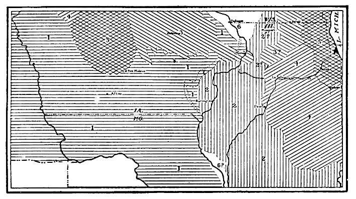
III. The Kansan glacial stage. The Kansan stage is represented by a sheet of till occupying a large surface area in Kansas, Missouri, Iowa, and Nebraska (Fig. 582). Theoretically it extends under the later glacial formations to the northward, as far back as the Keewatin center of radiation. Much of this sheet of drift, as originally developed, has probably been rubbed away by later glaciations. Presumably a similar sheet was formed by a contemporaneous ice-sheet spreading from the Labradorean center, but it has not been certainly identified. The Kansan drift is clayey till, with little stratified drift. Stream action seems to have been notably inefficient at this time. This and some other consonant facts have led to the abandonment of the former notion that vast floods inevitably accompanied the melting of the ice.
[p. 876]
IV. The Yarmouth interglacial stage.[24] Where the Illinois till overlaps the Kansan (eastern Iowa), an old soil with deep subsoil weathering was formed on the surface of the latter before its burial.
V. The Illinois glacial stage. The exposed part of the Illinois drift appears at the surface in the southern and western portions of Illinois. It runs Lack under later formations to the northeast, toward the Labradorean center of radiation. It is not identified with any confidence east of Ohio, where its margin seems to have been overridden by the ice of the Wisconsin epoch. The identification of the Illinois drift in the Keewatin area is yet an open question. The Illinois till is clayey, with little assorted drift associated. The west edge of the Illinois ice-lobe pushed out into Iowa a score of miles, forcing the Mississippi in front of it.[25] The Kansan lobe had earlier invaded Illinois from the west, and probably forced the Mississippi east of its present course, if such an easterly course had not been taken before the Kansan epoch. Efforts to trace out the early courses of the Mississippi under the thick mantle of drift in Illinois and Iowa have not been entirely successful.
VI. The Sangamon interglacial stage.[26] Like the preceding interglacial stages, this is marked by peat, muck, old soil and subsoil, weathering, surface erosion, etc., on the surface of the Illinois drift. Judged by these criteria, the interval was not as long as the Yarmouth.
VII. The Iowan glacial stage.[27] The Iowan ice-sheet left a thin sheet of till (Fig. 582), marked by a profusion of large granitoid bowlders many of which lie on the surface. The known Iowan drift was formed by a lobe of the Keewatin ice-sheet, which extended down into the north-central part of Iowa, but fell short of the Kansan invasion of the same region.
VIII. The Peorian interglacial stage.[28] This is characterized in the same way as the preceding interglacial intervals, but less strongly.
[p. 877]
IX. The Wisconsin glacial stage (or stages). Following this epoch of readjustment, the ice radiated from the Labradorean, Keewatin, and Cordilleran centers (Fig. 560), and from many isolated heights. Nearly all the well-known mountain glaciation of the west is referred to this epoch. The margin of the ice-sheets assumed a pronounced lobate form, and the drift which they left is characterized by stout terminal moraines, numerous kames, eskers, drumlins, outwash aprons, valley trains, and other features distinctive of glacial action and glacio-fluvial co-operation. This drift-sheet, far beyond all the others, bears the stamp of the great agency of the period. The pronounced topographic expression of this formation is in contrast with the relatively expressionless surfaces of the older sheets of drift. A part of this difference is due to the greater freshness of the Wisconsin formation; but the larger part, apparently, is assignable to a stronger original expression.
The Wisconsin glacial epoch has been divided into two, an Earlier and a Later. They are, however, less distinct than the other epochs mentioned above, and so are grouped together here.
[p. 878]
The disposal of the ice in great lobes is referable to the influence of the great basins. Field studies indicate that broad, smoothbottomed basins, elongate in the general direction of ice movement, favored the prolongation of the ice into broad lobes, while sharp. deep valleys of tortuous course or transverse attitude had little effect upon the extension of the ice. A study of Fig. 560 will make clear the relation between the great ice-lobes and the broad, smooth valleys lying under or back of them.
The Later Wisconsin drift has nearly a score of concentric terminal moraines in some places.[^] Some of these represent readvances of the ice in the course of its general retreat, and others perhaps nothing more than halts sufficient to permit an exceptional accumulation of drift at the ice border. The older drift-sheets far as overridden by the ice of this epoch, were cut away more largely than in preceding epochs, and the scoring of the rocks below was more prevalent and profound.
Not all of these several sheets of drift have been seen in superposition, and the history sketched is based on the relations of the sheets of drift at different points.2 Theoretically, and perhaps really, the several sheets of drift are imbricated as shown in Fig. 583; but each sheet of drift is discontinuous beneath the overlying one, and this discontinuity goes so far that beneath the Wisconsin [p. 879] drift, for example, the several sheets are more commonly wanting than present.
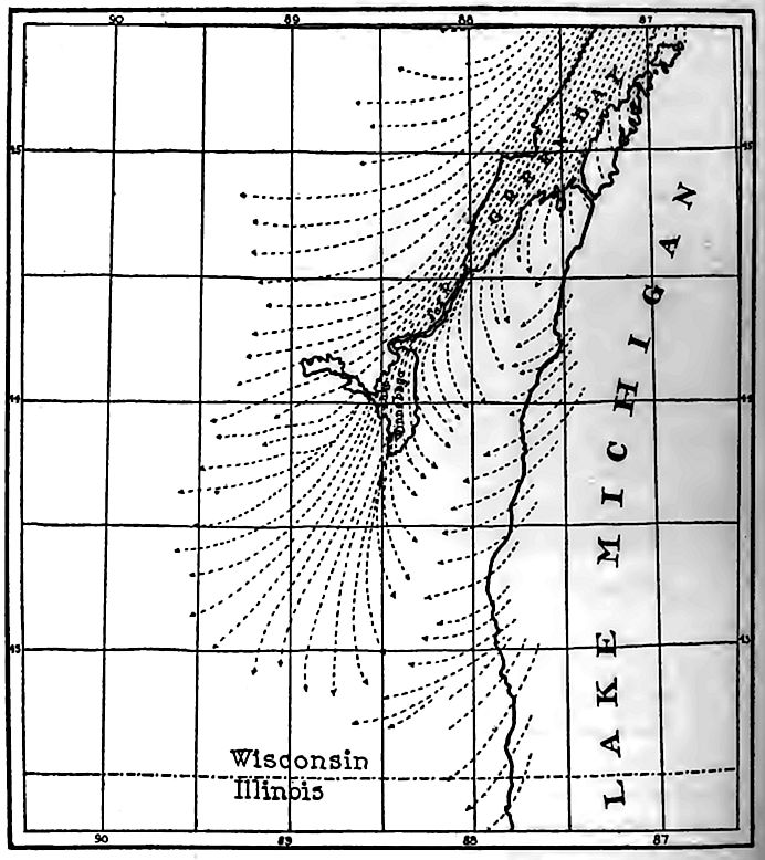
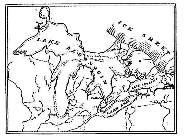
X. The glacio-lacustrine substage. In the course of the retreat of the ice of the Wisconsin epoch, a complex series of lakes arose between the ice border on the one hand, and the higher land fronting it on the other. Many of these lakes were temporary and shifting, and had shifting outlets. Thus as the ice border receded north of the divide separating the St. Lawrence basin from the Mississippi basin, glacial waters were ponded between the ice on the north and the divide on the south. This gave rise to many lakes, the history of which cannot be given here; but a brief sketch of the history of the Great Lakes will indicate the nature of the changes which took place.
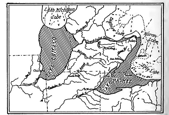
When the end of the Lake Michigan ice-lobe (Fig. 584) withdrew a little from the southern end of the Lake Michigan basin, a lake formed about its southern end, and found a point of discharge into the Illinois valley southwest of Chicago. The outflowing waters eroded its channel to greater depths, and it has since become the site of the Chicago drainage canal.[29] The glacial lake (Lake Chicago) thus initiated was gradually extended northward (Fig. 585) as the ice-lobe was melted.
A similar lake was formed about the head of the Lake Superior ice-lobe, and discharged to the Mississippi. Lake Maumee was formed about the end of the Erie ice-lobe, and discharged its waters by way of Fort Wayne into. the Wabash, and thence to the Gulf. A later stage of Lake Chicago and Lake Maumee is shown in Fig. 585, when, finding a lower outlet as the ice melted back, Lake Maumee sent its outflow across southern Michigan to Lake Chicago.
Somewhat later, Lake Saginaw developed about the end of the Saginaw ice-lobe, and discharged by way of Grand River into Lake Chicago, and thence to the Mississippi. Lake Maumee then discharged into Lake Saginaw.
[p. 880]
[p. 881]
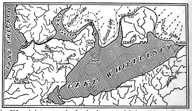
Later, the whole Erie basin, and a portion of that of Ontario, was freed of ice, and a lake twice the area of the present Lake Erie (Lake Arkona) developed. An advance of the ice changed the lake and in its changed outline it is known as Lake Whittlesey (Fig. 586).
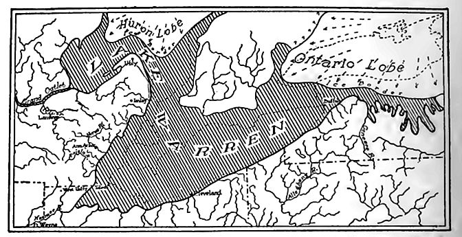
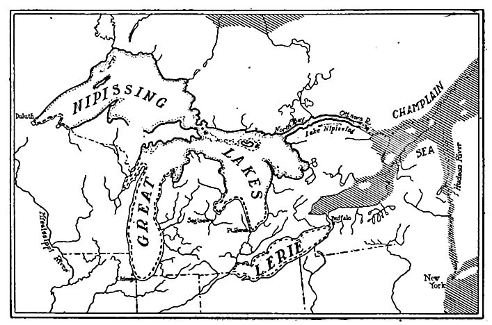
With further retreat of the ice, the ponded waters in the Saginaw basin became confluent with those in the Erie basin, which had, in the meantime, become extended into the borders of the Ontario basin, but were blocked in that direction by the Ontario ice-lobe. The extensive water-body thus developed is known as Lake Warren (Fig. 587). At first, this lake discharged across Michigan into Lake Chicago, but later, when the Mohawk valley was freed from ice, it offered the lower outlet, and the level of Lake Warren was drawn down, and it was divided into two lakes, Erie and Iroquois (Fig. 588).
Meantime, the glacial lakes in the basins of Lake Michigan and Superior experienced analogous shif tings of areas and of outlets. While Lake Iroquois was discharging through the Mohawk valley, Lake Algonquin (Fig. 588), formed by the coalescence of the glacial lakes of the Superior, Michigan, and Huron basins, was discharging its waters eastward. At first the outlet was probably by the St. Clair-Erie route, through Lake Iroquois, to the Mohawk; but later, when the ice had retired farther north, an outlet appears to have been effected from Georgian Bay, via the Trent River to Lake Iroquois.
When at length the ice withdrew from the Adirondacks so far as to permit the waters of Lake Iroquois to find an outlet lower than that by way of the Mohawk, a new series of lowerings of the lakes followed. At first the outlet seems to have skirted the Adirondacks and emptied into a glacially-ponded water-body (glacial Lake Champlain) that occupied the Champlain basin, and discharged southward into the Hudson. Later the outlet was to the Champlain arm of the sea presently to be noted. By this time Lake Algonquin had given place to the great Nipissing Lakes (Fig. 589), which had their outlet via Lake Nipissing to the Ottawa, and thence to the Champlain arm of the sea. Subsequently the outlet was shifted to its present position, probably by a gentle upwarping of the surface at the north.[30]
[p. 882]
Similar complicated histories doubtless attended the retreat [p. 883] of the ice in the Mackenzie and Hudson Bay basins, but little is yet known regarding them.
[p. 884]
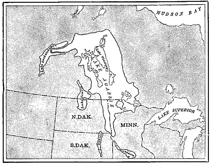
A very important lake was formed in the Red River valley of the North (Lake Agassiz,Fig. 590), discharging, in its earlier history, into the Minnesota River at Lake Traverse. Lake Agassiz was not connected with the complex system of basins of the St. Lawrence valley, and had a comparatively simple history. It grew to the northward with the retreat of the ice which held it in at that end, and continued to discharge into the Minnesota River until the retreat of the ice gave it a northerly outlet. It developed beaches while it discharged to the southward, and another set after the outlet was northward. On the final withdrawal of the ice, the lake was drained.
The evidence which demonstrates the existence of these expanded lakes is found chiefly in the deposits which they made, and in the topographic features which they developed about their shores. Many of the former shore-lines have been traced in detail, and most of them depart notably from horizontality. In general, they rise to the north and northeast.
It is probable that there were corresponding lacustrine substages at the close of each of the several glacial epochs, but their history is not known.
XI. The Champlain substage.[31] The significant feature of this stage is represented in Fig. 589, which represents an arm of the sea extending up the St. Lawrence to Lake Ontario, filling the basin of Lake Champlain, and probably connecting southward by a narrow strait along the site of the Hudson valley with the ocean. The sediments deposited in this arm of the sea contain shells and bones of marine animals. The marine fossils are found at various places about Lake Champlain at altitudes varying from 400 feet or less about the south end of the lake, to 500 feet at the north end. and about 600 feet near the east end of Lake Ontario.[32]
[p. 885]
At about the same time the sea stood higher than now relative to the land on the coast of Maine, where marine shells occur up to elevations of 200 feet or more,[33] and to still greater heights farther north.
The Loess
The term loess is used both as a textural and a formational name. Lithologically, it is a silt intermediate between sand and clay. It is generally free from stones of all sorts, except the concretions developed in it since its deposition. In the exceptional cases where stones occur in it, they are confined to its very bottom, or are found in loess which has slumped or been washed down from its original position. It is sometimes interstratified with sand, especially at its base where it is thick. On slopes and at their bases loess is often mingled with slope wash, talus, etc.
[p. 886]
Composition.[34] The loess contains angular, undecomposed particles of the commoner carbonates (calcite and dolomite) and silicates (feldspars, amphiboles, pyroxenes, micas, etc.), and several of the rarer silicates have been identified. Magnetite also is a common, though never an abundant, constituent. All these are subordinate to quartz. These constituents strongly suggest that the material of the loess was derived from the flour of the glacial mill. In color it is predominantly huffish brown, but in not a few places it has a grayish (bluish) cast a few feet below the surface.
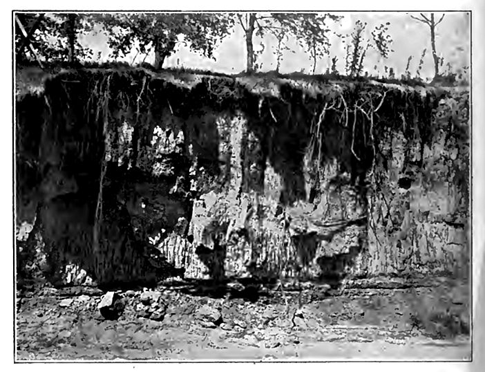
The loess often stands with vertical faces (Fig. 591) for long periods, where sand or clay would be degraded into slopes. I on the loess tend to assume the form of little canyons, because the [p. 887] silt of the road-bed is washed or blown away, while that on either side stands up with steep or even vertical slopes. Weathered faces of the loess often show a rude columnar structure (Fig. 591), the columns being one to several feet in diameter. The loess, as a rule, shows no’ stratification, but in its coarser phases there is often some suggestion of such structure, and where interbedded with sand, stratification is sometimes distinct.
Distribution. The best known loess in America and Europe is associated with glacial formations, though the loess extends far beyond the borders of the drift in some directions, in both continents. In China and other lands of Asia,[35] where loess has its greatest known development, it is not generally associated with glacial formations.
In North America the loess does not occur east of the Mississippi basin, and has no great development east of the Wabash River. It is wide-spread in Illinois and the states along the Missouri, and in the states along the Mississippi farther south. Within this area, its distribution is peculiar in that it follows the main streams that led away from the Iowan drift-sheet, and is found especially on the bluffs overlooking the valleys. On this account it was formerly known as the Bluff formation. In this bluff-position, it has more than its average thickness and coarseness of grain, and grows thinner and finer in grain back from the river bluffs until it is lost in a vanishing edge. At the same time, its material loses its distinctive characteristics.
Just south of the borders of the Iowan and Wisconsin drift-sheets, it mantles many of the divides between the main streams; but farther south it is more confined to the valley borders. It has little regard for topography, and can hardly be said to have an upper limit. Within the the drift-covered part of the Mississippi basin, it occurs (1) as a surface mantle overlying drift, and (2) between sheets of drift. South of the drift there are in places distinct sheets of loess, sometimes separated by a well developed soil zone. The surface of the lower sheet shows the effects of prolonged weathering [p. 888] and oxidation,[36] in some places. Loess occurs in isolated spots even as far west as Washington and Oregon.[37]
Age. The relations of the loess to the several drift-sheets make it clear that it was accumulated at different stages of the glacial period, but within the glaciated area the accumulation at one of these stages exceeds that at all others, both in volume and a real extent. The loess deposited at this stage is often referred to as “the loess,” and is usually correlated in time with the Iowan drift. It is at least later than the Illinois sheet of drift which it mantles, and earlier than the Wisconsin drift which overlies it. Locally, a thin mantle of loess overlies the Wisconsin drift, even its later parts.[38] No considerable body of loess older than the Illinois drift is known.
Thickness. The loess of the Mississippi basin rarely attains a thickness of more than a score or two of feet, and this only along the main valleys; but exceptionally its thickness approaches 100 feet. Thicknesses of 10 feet are much more common than greater ones.
Accessories. The loess contains characteristic accessories of two kindc, namely, concretions and fossils. The concretions arc of lime carbonate and iron oxide. Many of the former are irregular and of such shapes as to have been called “petrified potatoes”; but many of them have other shapes. The ferruginous concretions take various forms, one of which is the “pipe stem,” perhaps formed about rootlets. The fossils are chiefly gastropods (Fig. 592) almost exclusively of land species, or of such as frequent isolate ponds.[39] There is, however, a lowland silt formation classed bj some as loess, in which fresh-water fossils are found. The other fossils are bones and teeth of land mammals.
Origin. There has been much diversity of opinion as to the origin of the loess, the fundamental question being whether it is aqueous or eolian. There is little doubt that the loess-like silts which occur in the terraces of rivers are of fluvial origin; but some [p. 889] would not regard them as loess. Some, indeed, would so define loess as to make it an eolian product.
By the aqueous hypothesis, the loess is assigned to direct deposition by rivers, or their lake-like expansions. To make this possible it is necessary to suppose that the waters stood at elevations 200 to 600 feet higher than now, relative to adjacent surfaces, in the Mississippi basin. This involves difficulties that have never been satisfactorily met. Furthermore, if the waters of rivers or [p. 890] their lake-like expansions were high enough to cover the areas overspread by loess, it is not clear that there could have beeD u appropriate habitat for the land fauna of the time.
Under the eolian hypothesis, or at least one phase of it, tl river flats are supposed to have supplied the material of the loess, which was whipped up by the winds and re-deposited on the adjacent uplands. The rivers are thus made essential factors in the distribution, though not the direct agents of deposition. Thi hypothesis seems on the whole to best fit the phenomena of the larger part of the upland loess of the Mississippi basin. The constituents of the loess, which appear to have come from the glacial drift, were derived largely from the deposits made by glacial waters, or from later flood plain silts derived from the glacial formations; but it is probable that some of the loess was derived from glacial drift directly, before it became clothed with vegetation.[40]
The Duration of the Glacial Period
The desire to measure the great events of geological history in terms of years increases as the events approach our own time. The uncertainties attending such measurements are, however, so great that the results have an uncertain value, and do little more than indicate the order of magnitude of the time involved. Attempts to determine the date and duration of the glacial period fall mainly into two categories: (1) Estimates of the relative duration of the several glacial and interglacial epochs, and (2) estimates in years of the time since the close of the glacial period.
1. The best data for estimating the relative duration of the [p. 891] several glacial stages are found in the central basin of the Mississippi, for here only are all members of the series present. The criteria that have been used in estimating relative duration embrace (1) the amount of erosion of the drift, (2) the depth of leaching, weathering, and decomposition of its materials, (3) the amount of vegetable growth in interglacial intervals, (4) the climatic changes indicated by interglacial and glacial floras and faunas, (5) the times needful for the migration of faunas and floras, particularly certain plants whose means of migration are very limited, (6) the time required for advances and retreats of the ice, and some others. A few of these, as the first, are subject to direct measurement; but most of them are matters of judgment.
The average of the estimates of five glacial geologists who have most studied the data, is shown in the following table:
| From the Late Wisconsin[41] to the present, | 1 | time-unit |
| From the Iowan to the present, | 3 to 5 | “ |
| From the Illinoian to the present, | 7 to 9 | “ |
| From the Kansan to the present, | 15 to 17 | “ |
| From the sub-Aftonian to the present, | x | “ |
2. Of the efforts that have been made to measure in years the post-glacial interval, those based upon the recession of Niagara and St. Anthony Falls are the most significant.[42] It is important, however, to note precisely what is being measured. In both these instances, the measurement attempted is the time occupied in the recession of the falls from their starting point to their present positions. It is as important to know when they began their gorge cutting, as to know how long they have been occupied in it. The [p. 892] gorge cutting of the Niagara Falls could not have begun until the Mohawk outlet of the lakes (p. 883) was abandoned, because the escarpment through which the cutting subsequently took place was submerged while Lake Iroquois discharged through the Mohawk valley. The time measured by the Niagara cutting is only that which has elapsed since the ice retired from the north flank of the Adirondacks far enough to permit the waters of the ancestral Lake Ontario to find an outlet lower than the Niagara escarpment, and no very effective cutting could take place until the waters were withdrawn to something near their present level.
If the border of the ice-sheet at this stage (Fig. 588) is compared with the border of the ice at the maximum Wisconsin stage, it will be seen that it had retreated some 600 miles, and it cannot be assumed that the retreat was an uninterrupted one.
Before attempting to place a value upon the period so represented, the time at which the gorge below St. Anthony Falls began to be cut may be considered. It is to be presumed that for a time after the retreat of the ice-edge north of the site of these falls, the Mississippi valley was being aggraded, for the outflowing drainage must be presumed to have been overburdened with glacial detritus. In support of this assumption is the abundant evidence that the Mississippi valley, as far down as the mouth of the Chippewa River, was filled with detritus to a depth of more than 100 feet. Farther south the glacial filling appears to have been 80, 70, 60, and 50 feet above the river, the last in the latitude of central Illinois.
When fluvio-glacial aggradation of the Mississippi valley ceased, it was necessary for the river to clear out its trench before effective cutting of the gorge below the falls could begin. Under any probable hypothesis, there must have been a retreat of the ice some 700 to 800 miles from its extreme extension (to Des Moines) during the last glacial epoch, before the cutting began. The rate of recession is unknown, but 200 feet per year is an improbably high rate. At this rate, the ice must have been receding well toward 20,000 years before the falls began. If the retreat of the ice previous to the beginning of the cutting of the Niagara gorge is taken at 600 miles, the time occupied, on the assumption of a retreat of 200 feet per year, is about 15,000 years.
[p. 893]
If the length of the Niagara gorge be divided by the average annual retreat since the successive positions of the falls were located by accurate surveys, the quotient is about 7,000. This result is, however, subject to several qualifications, chief of which is the fact that at the time of the beginning of the cutting of the gorge, the waters of the upper lakes flowed by a more northerly route to the sea, leaving only the waters of the Erie basin to pass over the falls. If the history is correctly read, it was only at a comparatively late date that the waters of the Upper Great Lakes went out through the Niagara River. These and other considerations have led Gilbert, Taylor, Spencer, and others to the view that the cutting of the narrower portion of the gorge was probably the work’ of the lesser volume of water from the Erie basin, and that the recession at this stage proceeded at a relatively slow rate, but that the rate of recession was accelerated when the upper lakes began to discharge their waters to Lake Erie. It is this accelerated rate that is used as the divisor in the simple computation that gives 7,000 years. In view of these considerations, it is thought that 7,000 should be multiplied several times to give the true time-estimate. Spencer places the period at about 39,000 years, and Taylor at 50,000 years as an approximate maximum. There are, however, those who do not accept the conclusions, and who appeal to other phenomena that cannot be discussed here.
From a comparison of the earlier and later surveys of St. Anthony Falls, the time of recession from the mouth of the gorge has been estimated at about 8,000 years. But considerations not taken into account in this estimate, make it clear that this estimate should be increased to 12,000 or 16,000 at least.
It will be seen therefore that even in these cases of best data, there are possible errors, and that these errors may affect the results to the extent of several hundred per cent. If the range of the estimates for Niagara Falls be placed at 10,000 to 50,000 years, and if this be added to the range of estimates for the time of retreat of the ice before the falls came into existence, 10,000 to 30,000 years more, the result is 20,000 to 80,000 years for the time since the beginning of the Late Wisconsin ice retreat. These may be taken for a rough, wide-ranging estimate of the time since the climax of the Late Wisconsin [p. 894] ice invasion. Using the estimates in the table of relative duration above, and remembering that we are multiplying such errors as there may be in the previous estimates, we reach the following dates for the climaxes of the several ice invasions :
| Climax of the | [Late] Wisconsin | 20,000 to | 80,000 | years ago. |
| “ “ “ | Iowan | 60,000 to | 400,000 | “ |
| “ “ “ | Illinois | 140,000 | to 720,000 | “ |
| “ “ “ | Kansan | 300,000 to | 1,360,000 | “ |
| “ “ “ | sub-Aftonian | y to | z | “ |
Little value is to be placed on estimates of this kind, except as means for developing a conception of the order of magnitude of the time involved.
Foreign
In Europe, the succession of ice epochs and formations is not less complex than in North America, though there is not complete agreement among geologists as to the number of glacial epochs.[43] In the Alps four glacial epochs are recognized.[44] These are designated[45] Giinz (pre-Kansan?), Mindel (Kansan?), Riss (Illinois?), and Würm (Wisconsin?). The glacial formations of other continents have not been studied in detail, in many places, but recent studies in Turkestan indicate that there were several glacial epochs in the Thian Shan Mountains.[46]
¶ The Cause of the Glacial Period
Many hypotheses of the cause of the glacial period have been offered, but none commands universal assent. Most of them appeal to a combination of agencies, but each centers on some one facto! which gives character to the hypothesis. They fall mainly into three classes: (1) those based on elevation of the land, the hypsometric hypotheses; (2) those based on phenomena and relations outside the earth itself, the astronomic hypotheses, and (3) those based [p. 895] on changes in the constitution, movements, or cloud-content of the air, the atmospheric hypotheses.
Hypsometric Hypotheses
The hypothesis of elevation.[47] Since the best-known glaciers are in mountains, the suggestion was natural that elevation of the glaciated regions was the cause of the great ice-sheets. The chief evidence of the elevation postulated is the submerged valleys of the sea-coasts, especially those of the northern latitudes. It has been held by advocates of this hypothesis that 4,000 feet or more of elevation is indicated by the northern fiords, and that this elevation, together with accompanying geographic changes, was competent to produce the Pleistocene glaciation. Those who question this view doubt the fact of so great elevation, and doubt whether any elevation which there may have been was contemporaneous with the ice-sheets. Further, they offer evidence that the land was lower than now at certain important stages of the glacial period. The elevation hypothesis also encounters difficulty in explaining the interglacial intervals, now well established, and in accounting for the markedly mild climate of some of them. The hypothesis, in its simple and popular form, would seem to require a great elevation of a large part of two continents, for each ice epoch, and a great depression for each interglacial epoch. This can hardly be granted. On the whole, this hypothesis has lost rather than gained favor, as evidence has accumulated.
Astronomic Hypotheses
Croll’s hypothesis.[48] A semi-astronomical hypothesis was advanced by Croll in the latter part of the last century. For a time it was widely accepted, especially in Europe. It is founded primarily on variations in the eccentricity of the earth’s orbit, combined with the precession of the equinoxes.
The orbit of the earth is slightly elliptical, and this ellipticity is [p. 896] subject to considerable variation. This does not alter the total amount of heat received by the earth, or by either hemisphere, from the sun; but it affects the distribution of heat within the yen. shortening or lengthening the cooler and warmer seasons, according as they fall in the perihelion or the aphelion part of the earth’s orbit. Thus the hemisphere which has summer in perihelion has a short summer with much heat per hour; the other hemisphere has a long summer with less heat per hour. The precession of the equin< i reverses the seasonal relations of the hemispheres every 10,500 years. At present the earth is nearest the sun in winter in the northern hemisphere (summer in the southern hemisphere). In 10,500 years the earth will be nearest the sun in the summer of the northern hemisphere (winter of the southern hemisphere). We shall then have a shorter summer with more solar heat per hour than now, and a longer winter with less heat per hour. Croll’s hypothesis is built upon the belief that snow-accumulation would be favored by long winters, and snow-melting reduced by short summers. The hypothesis is that the glacial epochs were the times of aphelion winters during periods of great eccentricity.
It is admitted that these astronomical relations are insufficient in themselves to produce the observed glaciation, and so certain terrestrial conditions are made important elements in the working force of the hypothesis. Thus it is held that the zone of the tradewinds and the thermal equator would be shifted from the glaci.v hemisphere toward the warmer one, and that this shifting would turn a large part of the warm equatorial waters away from the cooler hemisphere. Croll held that if the trade- wind belts were shifted southward a few degrees, a large part of the equatorial current would be south of Cape St. Roque, and so turned into the South Atlantic, greatly lowering the temperature of the northern hemisphere. When the southern hemisphere was passing through cold period, nearly all the equatorial current would be north oi Roque, and this would give the northern hemisphere a moist interglacial epoch.
If the hypothesis were correct, (1) glacial epochs should alternate between the northern and the southern hemispheres, and (2) their duration should be limited to an appropriate fraction of the precessional [p. 897] period (21,000 years). This appropriate fraction is probably about that which effective winter bears to the whole year. In the middle latitudes, the effective period of cold would perhaps be 5,000 or 6,000 years; in the high latitudes, one-half or more of the precessional period. These peculiarities of the hypothesis afford a means of testing it. If it be true, the glacial episodes should bear evidences of equal length; they should all be short, and all of those in the same period of eccentricity, equally distant from each other in time. If the computed periods of eccentricity are correct (which has been questioned), there could only be a few alternations of glaciation between the hemispheres within a given period of high eccentricity, while none of them could be more recent than 60,000 years; indeed, Croll placed the close of the glacial period 80,000 years ago.
The glacial studies of recent years seem to show that the intervals betweeii the different invasions are of very unequal duration, and that the most recent is relatively young. It has also been found that glaciation was extended notably beyond its present limits on the lofty mountains of the equatorial regions, though this climate should not have been much affected. The Labradorean and Keewatin ice-sheets pushed out from what appear to have been their centers about 1,600 and 1,500 miles respectively. If one foot per day be allowed for the advance of the margin — an estimate much beyond the probabilities — it would take more than 20,000 years for the ice-edge to reach the extension observed. This is nearly the whole of the precessional period. Nor is the difficulty escaped by assuming that the snow-field grew up simultaneously over the whole area, or some large part of it, for numerous bowlders are found 600 to 1,000 miles from their probable sources. To allow time for the residue of winter snow above summer melting to build itself up to a height capable of giving effective motion, and then to allow time to carry drift this great distance at any probable rate of motion, taxes the hypothesis very severely, to say the least. On the whole, the result of prolonged study of the hypothesis has been to weaken, rather than strengthen it.
Other astronomical hypotheses. Attempts have been made to base other theories on the eccentricity of the earth’s orbit, and [p. 898] also on variations in the obliquity of the ecliptic; but none of them has gained much acceptance. They encounter most of the difficulties of the Crollian hypothesis, in somewhat different forms. There have been speculations upon the possible passage of the earth through cold regions of space, but there is no astronomical basis for them.
The hypothesis of a wandering pole. It was early suggested that the axis of the earth may have been shifting its geographic position, and that the Pleistocene glaciations were but polar glaciations of the existing type, at a time when the north pole was 15° or 20° south of its present position. So long as the theory of a thin crust resting on a liquid nucleus, and capable of sliding over it, was accepted, the mechanical difficulties of this hypothesis did not seem insuperable; but if the earth is essentially rigid, as seems almost certain, the dynamic objections to the hypothesis seem fatal to it. The distribution of the ice-sheets of the earlier glacial epochs also raises objections to this as a general theory.
Atmospheric Hypotheses
Hypotheses have been based on the direction of the prevailing winds and also upon the degree of cloudiness; but these have no1 been satisfactorily connected with known causes and with the conditions prevailing in Pleistocene times. Furthermore they have not been worked out into detail so as to fit the facts of periodicity and localization, facts which all hypotheses must meet before they can have serious claims to acceptance. Winds and clouds were no doubt factors in glaciation.[49]
The leading hypothesis of the atmospheric class is based chiefly on a postulated variation in the constituents of the atmosphi especially in its amount of carbon dioxide and water. Both 1 1 elements have high capacities for absorbing heat, and both arc ing constantly supplied and constantly consumed. Periods of great land elevation, extension, and erosion are periods of great consumption of carbon dioxide, for, on account of the great contact which the exposed surface presents, the carbon dioxide takes part in the decomposition of rock in a large way. So also, at times of [p. 899] great land elevation and extension, the sum total of evaporation of water was reduced, and the average amount of water vapor in the air was correspondingly lowered. The great elevation of land at the close of the Tertiary seems to afford conditions favorable both for the consumption of carbon dioxide in large quantities, and for the reduction of the water content of the air. Depletion of these heat absorbing elements was equivalent to the thinning of the thermal blanket which they constitute. If it was thinned, the temperature was reduced, and this would further decrease the amount of water vapor held in the air. The effect would thus be cumulative. The elevation and extension of the land would also produce its own effects on the prevailing winds and in other ways, so that some of the features of the hypsometric hypothesis form a part of this hypothesis. This hypothesis also takes into account the action of the ocean in absorbing and giving forth carbon dioxide under the varying conditions that prevailed. It is thus a highly complex hypothesis and cannot be fully set forth here.[50]
By variations in the consumption of carbon dioxide, especially in its absorption and escape from the ocean, the hypothesis attempts to explain the periodicity of glaciation. Localization is attributed to the two great areas of permanent low pressure in proximity to which the ice-sheets developed.
While this hypothesis is still new and on trial, it is almost if not quite the only one which has been worked out into details so far as to fit the leading facts as now developed by studies of the glacial formations. It should be understood, however, that its truth remains to be established, and that modifications and additions may yet be required,
¶ Formations Outside the Ice-sheets
While the glaciation of middle and high latitudes was the most striking event of the Quaternary period, by far the larger part of the earth’s surface was not affected directly by the ice, and outside [p. 900] the area of glaciation, the commoner phases of erosion and deposition were in progress, and non-glacial Pleistocene formations are wide-spread. Under the varied conditions of the period, various classes of deposits were made, among which were the following: (1) Eolian deposits, conspicuous along many shores and rivers, and in sundry arid regions, and inconspicuous as dust over much larger areas. (2) Fluviatile deposits, made by streams (a) with and (b) without connection with the ice. These deposits occur along most streams of low gradient, and along many others. Kindred deposits were made by sheet-floods and temporary streams, even far from the courses of permanent streams. (3) Lacustrine deposits of both the glacial and non-glacial types, made in existing lakes and about their borders, and also over the sites of the numen >us lakes which have become extinct since the beginning of the period. (4) Deposits made by springs. (5) Terrestrial organic deposits (peat, calcareous marl, etc.) occur outside the area directly affected by the ice, but are more common in the ponds and marshes to which glaciation gave rise. (6) Marine deposits, on lands submerged during the Pleistocene period, and doubtless over essentially all of the ocean bottom. (7) Volcanic rocks of Pleistocene age are found in our continent, chiefly west of the Rocky Mountains, though volcanic dust is widely distributed on the Great Plains. All these kinds of deposits were doubtless made at other periods, but have not been so generally preserved.
The average thickness of the Pleistocene deposits is not great. Glacial drift and Pleistocene accumulations of debris at the ba of mountains are sometimes several hundreds of feet thick; but otherwise the thickness of non-glacial Pleistocene deposits rarely exceeds a few score feet.
On the Atlantic and Gulf Coasts
On the Coastal Plain of the Atlantic and the Gulf of Mexico, there is a wide-spread but thin body of gravel, sand, loam, and clay, referred to the Pleistocene period. It ranges from sea-level up altitudes of several hundred feet, though most of it lies below 200 feet. All of the non-glacial post-Tertiary deposits of the Atlantic and Gulf plains were formerly grouped together under the name [p. 901] Columbia; but the materials formerly grouped under this name represent at least three somewhat distinct stages of deposition.[51]
The oldest subdivision of the Columbia series is found at levels higher than those of the younger subdivisions. In the principal valleys, it constitutes broad but often rude terraces, which rise up-stream. Up the Potomac, the Susquehanna, the Delaware, and other valles, the terraces rise to altitudes notably above those attained by the formation outside the valleys. In New Jersey this member of the Columbia series is called the Bridgeton formation.
In the District of Columbia, the second member of the Columbia series covers rock terraces 100 feet or so below the oldest member phase of the series (Fig. 593). The relations of the two subdivisions indicate that extensive erosion followed the deposition of the first, and that the broad valleys then developed were subsequently aggraded by sediments similar to those of the preceding epoch of deposition. The two deposits are so nearly alike in composition that their separation is based chiefly on their topographic relations. This member of the Columbia series is called, in New Jersey, the Pensauken formation.
The third phase of the composite Columbia is found at still lower levels along the streams and coasts. Its disposition is such as to show that the second phase of the Columbia formation had been somewhat extensively eroded before the deposition of the third. In the valleys formed during this interval of erosion, and along the coast at accordant levels, the third member of the series finds its chief development. Outside the valleys, the landward edge of this member of the series is as ill-defined as the landward edge of the older members in the inter-stream areas. In New [p. 902] Jersey, this member of the Columbia series is called the Cape May formation.Fig. 594 shows, diagrammatically, the supposed relations of the three phases along an interfluvial tract, from the coast inland.
The various members of the Columbia series rest unconformable on older formations. On the Atlantic Coast, the older divisions often rest on the Lafayette formation, and often on terranes from which the Lafayette had been eroded before the deposition of the Columbia series (Fig. 595).
Fossils. The Columbia series rarely contains fossils; but at a few points shells of fresh-water mollusks have been found in the Pensauken a few feet above sea-level. Marine shells have been found in gravels which are perhaps of Pensauken age, on the east coast of New Jersey. Such evidence as the few fossils afford, therefore, is against the marine origin of at least parts of the formation. The Cape May formation, like the older Pleistocene formations of the Atlantic Coast, is generally without fossils, but marine shells have been found in it at a few points (southern New Jera a few feet (10 or less) above sea-level.

The origin of the Columbia and associated formations. The origin of the Columbia formation presents much the same problems as that of the Lafayette, and is probably to be explained in much the same way; that is, the series is looked upon as largely subaerial (pluvial and fluvial), the result of land aggradation. The occasion for renewed deposition on the Coastal Plain in the Quaternary period probably lay (1) partly in changes of gradient incidenl surface warpings, and (2) partly in the changes of climate of the period. Slight further upward bowing of the highlands wesl the coast probably stimulated the streams descending from them [p. 903] to increased erosion, and the deposition of a part of their loads on the plain below was a natural result. The poor assortment of the material, the common cross-bedding, the numerous trifling unconformities, and the absence of fossils, all are consistent with this interpretation.
The second factor contributed to the same end. The climate of the period was changeable, and at least periodically cold, as the recurrent ice-sheets show. Under these conditions a larger proportion of the precipitation than now was doubtless in the form of snow, and this was favorable to the flooding of streams during the melting seasons. Floating ice helped to transport the bowlders of the formation, and so to give it the heterogeneity which is one of its distinctive features, especially in proximity to the glacial drift. The cold climate probably affected erosion, and therefore [p. 904] deposition, in another way, for the reduction of temperature probably attended by a reduction of vegetation, and an incn of erosion. The reduction of vegetation was probably greatest just where erosion was most readily stimulated, namely, in the higher altitudes.
It is conceived, therefore, that the deposition of the principal subdivisions of the Quaternary series of the Coastal Plain resulted from the combined effect of slight surface warpings and climatic changes; that epochs of notable deposition alternated with epochs when erosion was dominant in the same regions; and that the materials of each principal stage of deposition were deposited, shifted, and re-deposited repeatedly, so that the Bridgeton, the Pensauken, and the Cape May formations are each really complex series, though they nowhere attain great thickness.
While the Cape May division of the Quaternary was being deposited, the sea transgressed some parts of the present coast to a slight extent, at the same time that deposition was taking place in the valleys scores of miles inland, and in some cases hundreds of feet above sea-level. If similar relations existed during the earlier stages of Quaternary deposition, the seaward edges of the deposits of each principal stage of deposition may be marine. It is probable also that the series contains estuarine phases of sedimentation, and it can hardly be doubted that each subdivision now recognized on the land has its synchronous marine phase beneath the sea.
The Cape May formation was essentially contemporaneous with the last glacial epoch, and it seems not improbable that the earlier members of the Quaternary system of the coast were made during earlier glacial epochs.
In recent times, dunes have been developed at numerous points along the coast, and their development and destruction is still in progress.[52] Humus deposits also have somewhat extensive development in the tidal marshes, and to a less extent elsewhere.
In the Interior
Some of the non-glacial Pleistocene formations of the interior, notably the loess, the valley trains, etc., have been referred to. [p. 905] Apart from such formations, there are others which seem to be measurably or wholly independent of the ice. The wide-spread gravels of the western plains have been referred to (p. 829), but their deposition continued into the Pleistocene, and is indeed still in progress. There are numerous tracts and belts of dunes where conditions favor their development, as in central Nebraska,1 and some parts of Kansas. Dunes are of common occurrence locally even east of the Great Plains, as about the head of Lake Michigan and along its eastern shore. Even where dunes are wanting, windblown sand and dust in small quantities are wide-spread.
Outside the region affected by the ice-sheets, erosion rather than deposition was the great feature of the Quaternary in the interior. In the erosion, wind, running water, and ground-water have co-operated.
In the West
The Quaternary formations of the west belong to all the several categories mentioned on p. 900, and in addition there is much glacial drift left by mountain glaciers. Few of these various sorts of deposits have received close study over any considerable area, though something is known of all. The deposits of some of the lakes at various points west of the Rocky Mountains, especially those of the Great Basin, deserve special mention.
Lacustrine deposits. The most considerable of the western Pleistocene lakes was Lake Bonneville[53] (Fig. 596) of which Great Salt Lake is the diminutive descendant. Its basin is believed to have been due to deformation and faulting. Previous to the formation of the lake, the basin is thought to have been arid, a conclusion based on the great alluvial cones and fans subsequently covered by the lake. During the pre-lacustrine period of aridity, such quantities of debris from the surrounding mountains were brought into the basin as to bury the bases of the mountains to depths of perhaps 2,000 feet, at a maximum.
[p. 906]
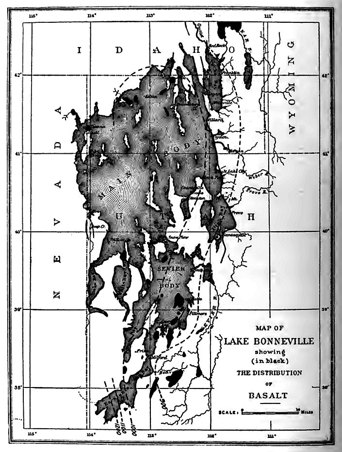
[p. 907]
Later, climatic conditions became such as to bring a large lake into existence, but after a time it appears to have dried up, probably because of another change of climate. Still later, the lake was restored, and its water rose higher than before, and found an outlet to the northward. In the course of time, evaporation from the lake again became more considerable than precipitation and inflow, and the lake gradually shrank to the present dimensions of Great Salt Lake. At its maximum, Lake Bonneville was more than 1000 feet deep, and had an area of more than 19,000 square miles; the maximum depth of Great Salt Lake is less than 50 feet (average less than 20) and its area but about one-tenth that of its ancestor It is apparently doomed to still further decrease by the diversion of water from the feeding streams for purposes of irrigation.
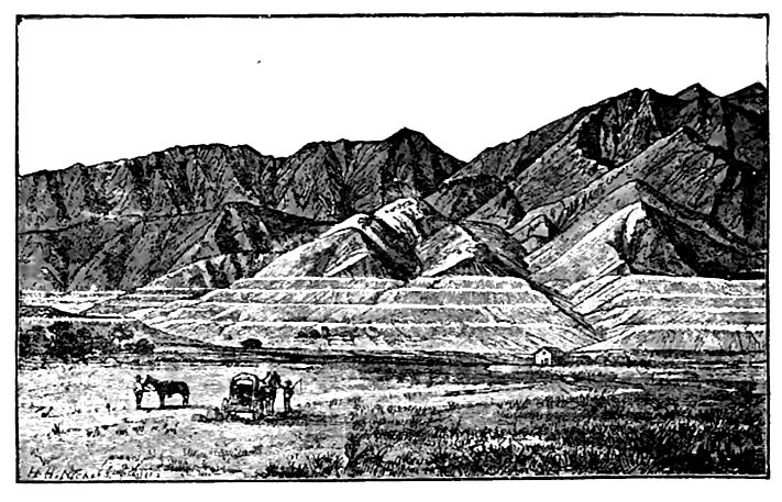
Terraces, deltas, and embankments of other sorts were developed about the shores of Lake Bonneville wherever the appropriate conditions existed (Figs. 269 and Figs. 597), and because of the aridity of the climate since the lake sank below them, they have been modified but little by erosion. As the lake dried up, deposits of salts were made, among which sodium chloride and sodium sulphate are most [p. 908] abundant. Great Salt Lake is estimated to contain 400,000,000 tons of common salt, and 30,000,000 tons of sodium sulphate.
Igneous eruptions (Fig. 596) have taken place within the basin at various stages of the lake’s history, even since Lake Bonneville disappeared. Since this time, too, there has been faulting in the basin (Figs. 598 and 599), with displacements of as much as 40 feet. Furthermore, the shore lines of the former lake have been deformed so that some parts of the Bonneville shore line are more than 300 feet higher than others (Fig. 596).
Farther west, but still in the area of the Great Basin, were other lakes, probably contemporaneous with Bonneville. Among them Lake Lahontan[54] was of importance. Its history and I hut of a lake which occupied a part of Mono Valley, California,[55] were similar to that of Lake Bonneville.
Glacial effects. The extent of glaciation in the western mountains has been outlined in the early part of this chapter. The erosive work of the mountain glaciers was considerable, as shown both by the extensive deposits of glacial drift, and by the forms of the valleys which the glaciers occupied. The most massive accumulations [p. 909] of drift are in the form of lateral moraines which in some cases are nearly or quite 1,000 feet high.[56] Under the conditions of active drainage which existed in the mountains, much of the glacial debris was carried beyond the ice by the water emanating from it, and deposited in the valleys and “ parks,” or on the plains below. Glacial cirques, the result of a peculiar phase of glacier erosion, are well developed in many of the glaciated valleys, as for example, in the Uinta Mountains.[57]
The characteristics of mountain valleys which were occupied by considerable glaciers, are essentially constant. They include (1) well developed cirques at the heads (PI. XVII) ; (2) the upper parts of the valleys were so thoroughly cleaned out by the ice that little loose debris, except that due to post-glacial weathering, remains; (3) numerous tributary valleys are hanging (Fig. 209), and their waters form cataracts; (4) at and near the limits of the ice, at stages when its end or edges remained nearly constant in position for a time, there are heavy accumulations of drift, lateral moraines being as a rule more conspicuous than terminal; (5) the valleys contain lakes (PI. XVII), some of which occupy rock basins, and some basins produced by drift dams; and (6) valley trains or outwash plains below the moraines. The partial removal of these deposits has developed terraces (Fig. 163).
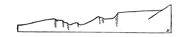
Glacial lake deposits. By obstructing valleys, the mountain glaciers of the west gave rise to numerous temporary lakes in which lacustrine sediments were laid down. The extent of such lakes in the west and northwest has not been determined, but where glaciation [p. 910] was extensive, derangement of the drainage was common, and deposits of glacio-lacustrine clay, hundreds of feet deep, are known at some points. Where such deposits were made in narrow valleys now drained, they have been partly removed, and their remnants constitute terraces.
Alluvial and talus deposits. In the basin region of Utah and Nevada, there are exceptional deposits of detritus, the accumulation of which was favored by topography and climate. The mountain ranges of the basin region are separated by broad depressions. From the steep slopes, detritus is carried down both by descending torrents and by gravity, and while it is largely deposited at and against the bases of the mountains, some of it is spread widely over the surrounding plains. This debris is mainly unstratified, or poorly stratified, and some of it is very coarse. It occurs in greatest quantity where canyons issue from the mountains, and in such situations huge fans of bowlders, sometimes 1,000 feet in height, are found.[58] The torrents were able to carry this coarse material so long as they were confined within the canyons, but with the change of gradient below, the water gave up its load. As the glacial deposits increase in importance to the north, talus and other subaerial accumulations become less conspicuous, and are of m.uch less importance in Montana, Idaho, and Washington, than in the more arid and unglaciated regions farther south.
Eolian deposits. The wind is an important agent of erosion and deposition in the west. Its erosive work is shown in the peculiar carving which affects the cliffs and projections of rock at many points (Fig. 62), and its depositional work by the dunes, which are not rare. The erosive work of the wind here is far greater than is commonly appreciated by those unfamiliar with arid regions.
Deposition from solution. About many springs, as in the Yellowstone Park, deposits of siliceous sinter and calcareous tufa are now making (Fig. 175). Considerable deposits of a similar nature antedate the present by a notable interval of time, but probably fall within the limits of the Quaternary period.
Marine deposits. At some points along the western coast of the United States marine deposits reach inland some distance from [p. 911] the sea. They reach altitudes of 200 or 300 feet in California[59] and Oregon, and perhaps’ even higher. The submergence indicated by the position of these beds must have given origin to considerable bays in the lower courses of the Columbia and Willamette valleys. By far the larger part of the marine Quaternary deposits of the coasts of the continent are still beneath the sea.
Igneous rocks. The Quaternary eruptions of North America have not been clearly separated from those of the late Tertiary, but there are some igneous rocks which are Quaternary, some of them even late Quaternary. Mount Shasta shows several postglacial lava-flows,[60] and there are small cinder cones on alluvial cones at the east base of the Sierras in southeastern California. In southern California (Mohave desert) and northern Arizona (vicinity of Flagstaff) there are cinder cones, and lava- flows of limited extent which are so slightly touched by erosion that there can be little doubt that they date from a time long subsequent to the beginning of the Quaternary period. Judged by the same criteria, there are lava-flows and cinder cones of Quaternary age in New Mexico, Colorado, Utah, Nevada, Oregon, (p. 382), Idaho,[61] Washingf on,[62] and at various points in the Sierras.[63] On many of them vegetation has hardly begun to gain a foothold. Gilbert estimates that of 250 lava-fields observed in these states, 15% are of Pleistocene age, and of 350 volcanic cones in the same states, 60% are considered to be Pleistocene.[64] Volcanic ash is interbedded with loess at various points in eastern Washington and Oregon,[65] and overlies glacial moraines in some parts of Alaska.
¶ Changes of Level during the Pleistocene
The very considerable changes of level which marked the closing stages of the Pliocene have been mentioned, and many of them [p. 912] doubtless continued into the Pleistocene. Minor movements of later date, such as those which affected the basins of bakes Bonneville and Lahontan during the Pleistocene have also been noted, but such changes are probably but a meager index of the crust al warpings of the period. Specific data on this point are less abundant than could be desired, for the phenomena of erosion and deposition which followed the elevation of the Ozarkian or Sierran epoch are not readily differentiated from the similar phenomena resulting from later elevation. Nevertheless evidence of Pleistocene changes of level, as distinct from late Pliocene, are not wanting, especially near the coasts and about the shores of the Great Lakes.
From the evidence at hand, it appears that deform ative movements were wide-spread both in the western mountains and in the area covered by the great ice-sheets. In general, the areas covered by the ice-sheets have risen since the ice melted. It is a tenable hypothesis that the rise, or some part of it, resulted from the melting of the ice, and that it followed a depression caused by the weight of the ice. The rise of the land has on the average been greatest where the ice was thickest.[66] This rise of the glacial centers is shown in various ways, but especially by the raised beaches along the coasts, and by the deformed shore lines of the interior lakes. Thus the shore lines of Lake Agassiz[67] are considerably higher at the north than at the south, their inclination being as much as a foot to the mile in the northern part of the basin. The shore lines of Lake Iroquois[68] (p. 883) decline from the northeast to the southwest at the average rate of three and a half feet per mile. East of the east end of Lake Ontario they are about 400 feet higher than at the west end. The beaches of Lake Algonquin[69] (Fig. 588) are 25 feel above the present lake at Port Huron, and 635 feet above the lake at North Bay, Ontario. The shore lines of the other lakes show comparable warping.
There have been changes of level, though less extensive in most places, in regions which were not glaciated. Thus along the [p. 913] Atlantic coast south of the drift there have perhaps been complex movements, but of no great range, in the course of the period. On the whole, elevation (relative) appears to have exceeded depression, but the latest movement (present) appears to have been one of sinking, as the drowned ends of the valleys show.
It is not improbable that movements of equal magnitude have affected the interior regions of the continent, but except about the lakes, there is no datum plane like the sea-level to which these changes may be readily referred. In a few places, notable local deformation is known. In western New York[70] and Ohio, the solution of underlying gypsum and salt is suspected of being the occasion of some of the slight deformations which have been observed.
Some of the islands of Southern California seem to have risen, relatively, some 1,500 feet since the Pliocene. Other parts of the California coast, and some of the adjacent islands, have been subsiding during the same period.[71] Near San Francisco, the surface is thought tc have ranged from 1,800 feet below its present level, to 400 feet above.[72] Along the northwestern coast of Oregon, a rise of at least 200 feet during the Pleistocene[73] has been estimated.
Foreign
The salient points in the glacial history of Europe have been sketched and some indication has been given of the extent of the deployment of ice in other continents. It need only be added here that outside the areas affected by the ice, there are, in all continents, accumulations of sediment of the sorts just enumerated. In Europe there are cave deposits of Quaternary, perhaps of glacial age, which are of especial interest because they contain human relics, probably the oldest known. The relics consist of rude stone implements, bones of mammals with human markings on them-, and bones of human beings.
[p. 914]
¶ The Life of the Pleistocene Period
Destructive effects of glaciation. Glaciation was the great physical event of the Pleistocene period, and its effect on the life of the times is the topic of chiefest interest in connection with the life of the period. It is reasonable to believe that the successive ice-sheets, several million square miles in extent, destroyed much life, and caused great change in that which survived. The logic is so cogent that we must believe it to be true; yet so far as the record shows, the difference between the preglacial life and the postglacial is less than might have been anticipated. Thus more than half the known species of the marine Pliocene invertebrates arc still living, whereas, in the transition between several of the more ancient periods, nearly all species disappeared. Of the Pliocene plant species, a very considerable percentage are still living. The land vertebrates, on the other hand, were very generally replaced by new species, and the same appears to have been true of the insects.
At the height of glaciation, the sum total of life on the globe must have been greatly reduced. Even the re-expanded life of to-day is probably inferior, quantitatively, to that of the middle Tertiary. Not only this, but existing life is, on the whole, probal >ly pocrly adjusted to its surroundings, for it is improbable that, in the millions of square miles where life was destroyed by the ice, there has yet been worked out the best balance between the veget ation and the soils and climate on which it depends, between the carnivorous animals and the herbivores on which they prey, not to speak of all the complicated minor relations that are involved in a well-adjusted peopling of the earth.
To-and-fro migration. An important biological effect of the ice-sheets on life, was enforced migration in latitude. With every advance of the ice, the whole fauna and flora of the affected region had to move on in front of it, or suffer extinction. The arctic species immediately adjacent to the ice border crowded upon the sub-arctic forms next south of them, the sub-arctic forms crowded upon the cold-temperate, and these in turn upon the warm-temperate and so on. It is not unlikely that the limits of the tropical [p. 915] zones were somewhat shifted, and the zones themselves narrowed. During the interglacial epochs, migrations were reversed. As the zones were shifted back and forth alternately by the advances and retreats of the ice, every organism was under special stress to adapt itself to a new zone, to migrate, or to die. There appear to have been four to six such to-and-fro migrations in America and Europe, and the swing of these movements was several hundred miles, and in some cases perhaps one to two thousand miles. During some of the interglacial epochs, the life of middle latitudes indicates a climate milder than the present, and hence that the icesheets were reduced at least as much as now. During some of the interglacial epochs, northern lands seem to have supported as many plants and animals as now. This carries the conclusion that the migratory swing in these more pronounced cases was some 2,000 miles in North America, and more than 1,000 miles in Europe. As indicated in the physical description, other geological evidence warrants the belief that the interglacial intervals were long enough to permit a complete northern return of the life which was forced south during glacial epochs, and the fossil evidence supports the conclusion that the climates were congenial enough to invite it.
The forced migrations must, in their nature, have been peculiarly effective in causing a severe struggle for existence. Forms previously specialized to meet local conditions were put to a most adverse test, for the invading ice forced every form within the glaciated area to move on, while the fringing zones of depressed temperature encircling each ice-sheet, forced plant and animal life, even beyond the ice border, to seek new fields. An incidental result of this wholesale migration was an unwonted commingling of plants and animals, for every aggressive form pushed forward in the van of the advancing zone, and hence came into new organic environment, while every laggard fell behind, and was overtaken by less reluctant migrants.
Climatic adaptations. It has been remarked before that the floras of the middle Tertiary were mixed, judged by the present distribution. Types which we now regard as tropical lived in high latitudes, with forms which are now boreal. So also species that are now boreal lived in low latitudes then with forms which are now [p. 916] tropical. The to-and-fro movement of the climatic zones seems to have sorted out the mixed assemblage, or to have forced special types into special adaptations, or both, so that to-day most species are confined to definite climatic zones. Adaptation to climatic zones and restriction to them seem therefore to have been favored by the climatic fluctuations of the glacial period.
Relics of glacial migrations. Significant evidence of the northerly and southerly migrations of the glacial period is found in the existing life of the higher mountains within or near the borders of the once glaciated areas. It is obvious that at the time the ice stood in the vicinity of these mountains, the only life which could occupy them was of the arctic type. As the ice retired to the north, the arctic life of the surrounding lowlands moved northward after it, and the temperate life came on to take its place. In the mountains, however, the arctic life still found congenial conditions, by ascending to higher and higher altitudes as the warmer climates advanced. It was thus cut off from the retreating arctic life of the lowlands, and at length isolated. In the high mountains, such life still finds suitable conditions. In some of the higher parts of the northern Appalachians, plants, insects, and small mammals whose kin now live in the arctic zone, remain to this day. The same point is still more strikingly illustrated in the Alps.
Life of the Interglacial Stages
By far the larger part of the fossils whose exact relations to the ice invasions can be fixed, are found in the interglacial beds. These, therefore, possess the highest order of value.
The Toronto beds. The most instructive interglacial beds carefully studied in America are those on the Don River and in the Scarboro cliffs, near Toronto.[73:1] The fossil-bearing beds are underlain by a sheet of bowlder clay the age of which is not detern lined, but it is the equivalent of one of the older drift sheets. Its upper surface was eroded before the fossiliferous interglacial beds of s1 ratified sand and clay, with a maximum thickness of more than 150 [p. 917] feet, were deposited upon it. The lower part of the interglacial accumulations constitutes the Don formation, and the upper part, the Scarboro formation. Subsequent to the erosion of the latter, thick sheets of bowlder clay and assorted drift of Wisconsin age were deposited upon it.
The Don formation contains a warm-temperate fauna and flora, and the Scarboro formation a cold-temperate fauna and flora above. Up to 1900, the flora of the warm-temperate stage had yielded 38 species of plants, many of which indicate a climate appreciably warmer (3° to 5°) than that of Toronto at present. Among these are the pawpaw and the osage orange, which now flourish only in more southerly latitudes. The fauna includes about 40 species of mollusks, some of which are now living in Lake Ontario, some in Lake Erie, while some are not known in the St. Lawrence waters.
The flora of the Scarboro beds embraces 14 species of plants, and the fauna 78 species of animals, 72 of which are beetles. This assemblage implies a climate of about the type which now prevails in southern Labrador. The arctic fauna and flora which should theoretically have followed this cold-temperate one, heralding the approach of the next ice-sheet, are undiscovered.
Other interglacial epochs. In other interglacial formations, there is evidence at many points of an ample growth of vegetation, recorded in peat and muck beds, in humus-bearing soils, and in twigs, limbs, trunks, etc., of trees. From these no great number of species has been identified. Recently, bones of horses (more than one species) have been found in the Aftonian interglacial beds in Iowa,[74] along with bones of elephants and mastodons.
Marine Life
On the more northerly coasts. During that stage of the Wisconsin glaciation when the eskers of Maine were being formed, and the sea-level stood higher than now relative to the land along that part of the coast, arctic mollusks abounded in the shore-waters and were buried in marine clays formed contemporaneously with the eskers.[75] The species live now in waters that are near the freezing [p. 918] point most of the year. Remains of walruses, seals, and whales also have been found. In the Champlain substage, the arm of the sea that occupied the lower St. Lawrence and Champlain valleys was peopled by a marine fauna of the same type, essentially, as that which now lives about the mouth of the St. Lawrence and on the coast of Labrador.
On the more southerly coasts. Away from the immediate influences of the ice-sheets, the record of marine life does not indicate any profound departure from the progressive modernization that had been in progress through the Tertiary period. It has been stat i d by Dall that the Pleistocene fauna of the Atlantic coast does not imply as cold waters as the Oligocene fauna does, and by Arnold that the Pleistocene fauna of the California coast does not imply as cool a climate as the Pliocene fauna of that coast. It is to be noted, however, that the known marine record may not cover more than a small part of the Pleistocene period, and that it is not certain, — perhaps not probable, — that the portion represented was one of the glacial epochs. When the ice was pushing into the ocean on the coast of Maine, as in the late Wisconsin epoch, and an arctic fauna occupied that coast, it is scarcely probable that a warmtemperate fauna lived on the southern coast; nor is it probable that, when icebergs were being set free into Puget Sound, and along all the coast to the north, a warm-temperate fauna lived on the California coast; but warm-temperate faunas on those coasts during interglacial epochs are entirely consistent with a climate such as that suggested by the Don beds.
The Terrestrial Life of the Non-glacial Regions
The life of the lands distant from the glaciated areas cannot now be correlated closely with the glacial and interglacial stages. One of its features was northerly types which appear to have been driven south by the advancing ice, and, later, to have followed its retreating edge northward. The mammoth and mastodon, the bear, bison, reindeer, and musk-ox, were characteristic members of this group. In mid-latitudes, there were several types on the verge of extinction in North America, such as the horse, tapir. llama, and sabre-tooth cat. It is not improbable thai there was [p. 919] intermigration with Eurasia by the northeastern or northwestern routes during the interglacial intervals. A second prominent feature of the faunas was a southern group consisting of gigantic sloths, armadillos, and water-hogs, whose forebears had come from South America a little earlier when the isthmian route was open to land animals.
The boreal group. As in the Pliocene, the proboscidians dominated the fields and forests of mid-latitudes. The mammoth ranged from Mexico northward, reaching Canada and Alaska at times of maximum deglaciation. In Siberia, the mammoth was covered with wool and hair, and was obviously adapted to a cold climate. The mammoth survived the glacial period in America, and its tusks and skeletons are not infrequently found in beds of peat and muck that have accumulated since, in northern United States and Canada. The mastodon also ranged northward into [p. 920] Canada, but since it emigrated to South America and crossed the tropics, it cannot have been ill-adapted to a warm climate. It likewise outlived the glacial period. Williston suggests that while mammoths were abundant in Kansas and on plains where forests did not prevail, mastodons were mostly confined to valleys and timbered regions, notably those of the eastern States, the eastern part of the Mississippi basin, and the Pacific coast.
Several species of horses have been found in western beds referred to the Pleistocene period. A gigantic elk ranged from Mississippi to New York. Two or three species of buffaloes roamed over the Ohio valley and southward to the Gulf, and remains of the musk-ox and reindeer, distinctively arctic animals, have been found as far south as Virginia and Kentucky. Bears, rather recent emigrants from Eurasia, were present, as were wolves and peccaries.
The southern group. Over against this assemblage of more or less boreal forms pushed southward by glacial advances, there was the group of South American immigrants, the monster slot lis. Megatherium, Mylodon, Megalonyx, and the gigantic armadillo Ghyptodon with a strong carapace and a massive tail plated with spiked ossicles (Fig. 601). The remains of this group have been found chiefly in caverns and crevices, or in the muck and mire about salt springs, or in fluvial deposits, the precise ages of which are difficult to fix. There is apparently nothing in the climatic conditions of such an interglacial stage as that which permitted pawpaws and osage oranges to flourish about Toronto, to forbid the presence of these animals in the most northerly ranges in which their relics are found, Pennsylvania and Oregon.
Pleistocene Life in Eurasia
The changes undergone by the life in Europe, during the glacial period, were similar to those already sketched for America.
During the first glacial epoch, a thoroughly arctic fauna lived in the North Sea, while during the first recognized interglacial epoch, the arctic fauna retreated northward. During this interglacial interval, a temperate flora, comparable to thai now living in England, clothed the British Isles, while the hippopotamus, elephant, deer, and other mammals invaded Britain by way of the [p. 921] land bridge which then connected it with the continent. A similar flora and fauna advanced to corresponding latitudes on the main land. A luxurious deciduous flora occupied the valleys of the Alps, and flourished at heights which it no longer attains. Toward the close of this interglacial epoch, the temperate flora gave place to an arctic flora.
During the second glacial epoch, according to Geikie,[76] the ice reached its maximum extent in Europe, and arctic-alpine plants occupied the low grounds of central Europe, while northern mammals, including the reindeer, the arctic fox, etc., reached the mountains of southern Europe, and even the shores of the Mediterranean.
During the second interglacial epoch, the arctic-alpine flora and the northern fauna of central Europe were replaced by a temperate flora and fauna. The plants which then occupied northern Germany and central Russia imply a climate milder than the present, and the mammalian fauna, which included the hippopotamus and elephant (Elephas antiquus), was in keeping with the flora. Toward the close of this interglacial epoch, however, a northern facies began to be assumed, and as the third glacial epoch came [p. 922] on, the northern types were pressed well to the south, though not so far as in the preceding epoch. In the third interglacial epoch the mammalian fauna included the Irish deer, the horse, the mammoth, and the woolly rhinoceros. The climate seems to have been congenial to a cool-temperate fauna.
During the remaining epochs, the oscillations were apparently less, and the to-and-fro migrations of life appear to have become less and less, corresponding to the diminishing oscillations of the glacial stages.
Pleistocene life of other continents. The Pleistocene life of North America and Europe were similar, but that of South America had a character quite its own. The major fauna was composed of two great elements, (1) the gigantic sloths and armadillos, which were indigenous to that country and very numerous, and (2) the descendants of the Pliocene mammals which had migrated from North America. Among the northern immigrants were horses, mastodons, llamas, tapirs, wolves, and a large variety of rodents.
Owing to the isolation of Australia, its organic development followed lines of its own. The vertebrate fauna consisted exclusively of marsupials and monotremes. In general, they differed, specifically, from those now living, and were, on the whole, larger. Although glaciers had but slight development in Australia, the effects of the wide-spread refrigeration of the higher latitudes was doubtless felt.
Comparatively little is known of the Pleistocene life of Africa. A moderate climate in the northern portion seems to be attested by fluvial accumulations which have yielded remains of the buffalo, antelope, hippopotamus, rhinoceros, and horse. These appear to have belonged to an early stage of the Pleistocene. A later stage is represented by mollusks of existing species, and a mammalian fauna embracing the elephant, buffalo, hippopotamus, antelope. sheep, camel, and horse, a group differing widely from the present occupants of the region.
Man in the Glacial Period
In America. Previous to the last decade of the last century, no small mass of prehistoric material of human origin had been [p. 923] assembled and somewhat widely accepted as conclusive of man’s presence in America in glacial times. The rise of a more critical spirit in archa3ologic geology, and the application of more rigorous criteria have, however, disclosed weaknesses both in the evidence and in the interpretations put upon it, with the result that man’s antiquity in America is a more open question to-day than it was thought to be fifteen years ago.
Prehistoric human relics in America range from the rudest stone chippings and flakings to skillfully fashioned and often polished handiwork in stone, metal, and bone. Following European precedent, the earlier students in America classed the rougher artefacs[77] as paleolithic, and interpreted them as indicating the presence of Paleolithic man, and of the Paleolithic or Old Stone age in America. The more perfectly fashioned artefacs were classed as neolithic, with corresponding reference to the Neolithic or New Stone age. Some investigators very properly regard “paleolithic” and “neolithic” merely as stages of early art, and not as chronological “ages,” or geologic divisions, but the terms have been much used in the latter sense.
The relics interpreted as paleoliths consist chiefly of rudely chipped pieces of flint, quartz, argillite, etc. (Fig. 602). With them other products of early art are found. The neoliths embrace a wider range of stone artefacs, typified by well-chipped arrowpoints, spear-heads, knives, and scrapers of flint or quartz, and by the ground and polished axes, chisels, pestles, mortars, and other implements of greenstone and similar tough or workable rock. The paleoliths, as defined above, were confidently interpreted as the work of an earlier and less cultured people, while the neoliths [p. 924] were known to have been the customary implements and weapons of the natives of the continent when first invaded by Europeans. Stone axes have been found in abundance in the ancient copper mines of the Lake Superior region, and thus the use of stone and of copper implements is shown to have been contemporaneous; but this was long after the retreat of the last ice-sheet. It is to be noted that the phase of the stone art designated neolithic was dominant on the continent until recent times, and is scarcely yet extinct, and that it was contemporaneous with the “Iron age” of Europe, entirely overlapping the “Bronze age.”
The chief points brought into question by the critical inquiries of recent years are (1) the reference of the ruder artefacs to a stage of art more primitive than that of the Indians and other aborigines, and (2) the reference of the gravels and other superficial formations in which they were found to the glacial period.
By a series of investigations relative to the first of the points, Holmes[78] reached the conclusion that the early inhabitants of the country, like the later Indians, resorted habitually to gravel-beds and to outcrops of appropriate rock to procure the raw material for their stone artefacs, and that it was their custom to test and to rough-out the material on the ground, leaving the chippings and the rejected material scattered about when the rough work was done. The more delicate work of shaping the rough material into implements was apparently done as need required, at their dwelling sites or other convenient places to which stone from the quarries was carried. A full series of the stages of manufacture, as thug interpreted, is shown in Fig. 603.
By virtue of this separation of the process of manufacture into two parts, (1) roughing out at the quarries, gravel-beds, etc., and (2) shaping tools at dwelling sites or elsewhere, there aros geographic separation of the products. The rude failures and rejects, together with the extemporized hammer-stones, cores, Makings, and chips, were scattered about the sites of the raw material, [p. 925] while the completed implements were liable to be found only about the dwelling sites, or wherever, in the course of their use, they were lost or thrown aside. In the light of this definite separation, it is not difficult to see how the idea of two stages of art might arise, and how easily the finds might be misinterpreted.
The most available sites for finding suitable raw material in a convenient form were the river gravels and the terrace formations. This was especially true in and about the glaciated regions where trains of glacial gravels led away from the ice-fields. In these, quartz, flint, chert, etc., were usually abundant, in the convenient form of pebbles and cobbles.
The rude artefacs in question have been found chiefly in such gravels, but gravels derived from chert-bearing limestone or quartzbearing rock are also fruitful sources. In other words, there is a correspondence between the distribution of the ruder artefacs, and that of the raw material. The distribution of the finished artefacs is much wider and more varied. There is special infelicity in supposing that great numbers of implements would be lost in glacial rivers during the glacial epochs, for the waters of these rivers must have been so cold and silty, that they contained little life. Later, when the climate was milder and the streams warmer and clearer, [p. 926] and when the adjacent country was filled with game and when the glacial gravels were exposed in bluffs and channels, these streams must have afforded abundant material for stone implements.
The demonstration of two stages in the manufacture of arrowpoints, spear-heads, knives, etc., as practiced by the aborigines of the country, raised the question whether there are any true paleolithic artefacs in North America. The difficulties of discriminating between “paleoliths” and “rejects,” if indeed they can be discriminated, is illustrated by Fig. 604. One of the chipped blades represented has been regarded as a typical “paleolith,” while the other forms are “rejects.”
It has been found that most of the artefacs in valley gravels are in their superficial portions, in their talus slopes, or in secondary deposits, many of which are of recent origin. Of the less superficial finds, many have been shown to be cases of relatively recent burial by natural means. The processes of streams in cutting down their channels in valley gravels are such that superficial material may be buried to very considerable depths. In their meanderings, they cut into the bordering terraces or uplands, developing steep bluffs. When the meanders shift, as they are sure to do, the bluffs grade down to a slope by the falling, or sliding, or washing of the top to the bottom, as illustrated in Figs. 605-607. The material which was in the top originally, may get into the base of the talus, and be buried deeply. Similar secondary burial takes place in all sorts of loose material of eolian, pluvial, and fluvial origin. It is to be noted that this is a normal process, not an exceptional one. There are other ways, too, notably scour and fill (p. 184), in which human relics may be buried in river gravels.
Without further details, it may be said that human relics have not been found, in America, in gravels known to have been deposited in the glacial period, or before. All that have been reported from glacial gravels, have been found either in such positions as to show that they were buried in post-glacial time, or in such posit i onto make this inference tenable. The existence of man in America in the glacial period or before is therefore not demonstrated.
Sources of good evidence. There are two classes of formations in which good evidences of glacial man, if there was such man in [p. 927] America, are to be sought, viz., (1) in undisturbed till-sheets below horizons affected by surface intrusion, and (2) in interglacial beds, where overlain by till and protected from all assignable sources of subsequent intermixture. Both these classes of beds have yielded fossils of other forms of life, and these alone have been seriously considered in the usual studies of the life of the glacial and interglacial stages. These beds have not yet yielded human [p. 928] relics in America, but they should do so in time, if man lived here in glacial or interglacial times.
In Europe. The European data indicating great antiquity of man are superior to the American. In Europe there are numerous caves in which the relics of man, mingled with those of extinct animals, have been securely protected by layers of stalagmite. While the ages of the stalagmite layers have rarely been fixed with certainty, or well correlated with the glacial stages, they bear inherent evidence of considerable antiquity. The European cave evidence seems to have no strict counterpart in America.
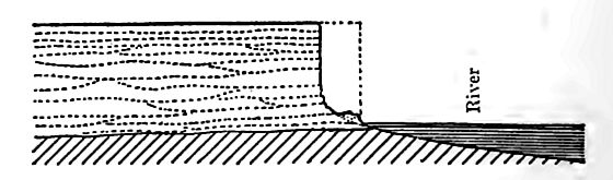
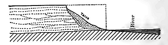
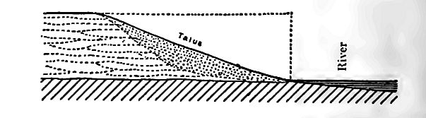
The association of man with extinct animals is a phenomenon that may mean the extension of man’s presence backward, or the extension of the animals’ presence forward; and to this doublefaced problem research has not yet furnished a final key. Obviously, [p. 929] however, the larger the number of animal types not known to have lived this side the last glacial stage whose remains are commingled with human relics, the stronger the presumption of man’s presence before the close of the glacial period. From this point of view, the European case seems to be strong.
There is one further feature in the European case that is, at least, suggestive. Two climatic groups of animals are associated with the human relics, — a subarctic and a subtropical. In the subarctic group, there were reindeers, mammoths, woolly rhinocerouses, arctic gluttons, musk-oxen, and other boreal forms; in the subtropical group, lions, leopards, hippopotamuses, hyenas, southern rhinoceroses, and other African types. These contrasted groups, as interpreted by James Geikie and others, imply migrations of the kind already sketched as characteristic of the glacial period. While it cannot be positively affirmed that there have been no climatic oscillations of a similar kind since the last glacial epoch, there is a somewhat strong presumption that those implied by these two classes of animals were connected with climatic oscillations of the glacial period. This presumption therefore connects man with at least the later of the glacial epochs.
The relics thus associated with extinct animals have been assigned to paleolithic man, and to a primitive stage of culture. This interpretation is based on the crudeness of the stone artefacs rather than upon the evidence of a higher order of art which the record presents. If, however, the rude stone artefacs are susceptible of being interpreted as the waste incidental to the making of good stone implements, — an interpretation which does not seem to have been yet fully adjudicated in Europe, — a more favorable judgment of the art of these ancient peoples would be reached; for associated with the ruder artefacs (or paleoliths), there are implements of bone, such as needles, awls, harpoons or spears with barbs, etc., implying some advance in art; there are carvings that show not a little skill, and drawings in which the elements of perspective and shading, as well as skill in delineation, are indicated (Fig. 608). These seem to imply a higher stage of art development than is consistent with the exclusive use of paleolithic stone implements. On the whole, present evidence seems to justify the conclusion of most [p. 930] European archaeological geologists, that man was present in southern and central Europe during the later part of the glacial period, and perhaps even early in the period. Penck[79] would place his beginni og as far back as the interglacial epoch which, he thinks, may correspond with the North American Yarmouth (p. 874).
References relative to the antiquity of man: Abbott, C. C, Peabody Acad. Sci., Salem, 1881; Proc. Bost. Soc. Nat. Hist., Vol. XXII, 1884; and Vol. XXIII, Smiths. Rept., 1875, and Pop. Sci. Monthly, 1889; Babbitt, F. K… Am. Nat., Vol. XVIII, 1884; Becker, G. F., Bull. Geol. Soc. of Am., Vol. II; Blake, W. P., Jour. Geol., Vol. VIII, 1899; Chamberlin, T. C, Jour. Geol., Vol. X; Geikie, James, The Great Ice Age, pp. 616-690; and Prehistoric Europe, pp. 568 et seq.; Gilbert, G. K., Sci. Am. Supp., Vol. XXIII, 1887; Lyell, Sir Charles, Antiquity of Man; McGee, W J, Am. Geol., Vol. XXII, pp. 96-126: Sci., new ser., Vol. IX, pp. 104-105; Salisbury, R. D., Sci., new ser., Vol. VI. pp. 977-981, 1897; Upham, Warren, Science, Vol. XVI, pp. 355-6; Am. Geol., Vols. XXX and XXXI; Whitney, J. D., Cal. Proc. Acad, of Sci., Vol. Ill, pp. 277-278; Am. Jour. Sci., 2d ser., Vol. 43, pp. 265-267, 1867; The Auriferous Gravels of the Sierra Nevada of California, Cambridge, 1879; Williston, S. W. Science, new ser., Vol. XVI; Winchell, N. H., Bull. Geol. Soc. of Am., Vol. XIV; Am. Geol., Vols. XXX and XXXI; Wright, G. F., Bull. Essex Inst., Vol. XIII, 1882; Ohio Arch., and Hist. Quart., 1887; The Ice Age in North America and its Bearings upon the Antiquity of Man, pp. 506-571; Man and the Glacial Period, pp. 243-307; Brit. Assoc. Adv. Sci. Rept. for 1891.
¶ Notes
A fourth center has been suggested. Wilson, The Glacial History of Nantucket and Cape Cod. ↩︎
This applies only to the radiations of the last glacial epoch. ↩︎
The phenomena pointing to the glacial origin of the drift have become so familiar that it is unnecessary to give extended references to the literature of the subject. They were emphasized in many of the early publications concerning the drift. The striae and other scorings of the ice are elaborated in the 7th Ann. Rept., U. S. Geol. Surv. The study of the drift from the standpoint of genesis is given in the Jour. Geol., Vol. II, pp. 70S 72 1 and 807 835, and Vol. Ill, pp. 70-97, and in Glacial Geology of Now Jersey, pp. 3 The geological Reports of all the states affected, and of Canada, contain descriptions of the phenomena. ↩︎
The Local Origin of the Drift, Jour. Geol., Vol. VIII, p. 426. ↩︎
7th Ann. Rept., U. S. Geol. Surv., pp. 155-248. An elaborate discussion of this topic. ↩︎
Jour. Geol., Vol. Ill, p. 655. ↩︎
Calhoun, Jour. Geol., Vol. IX, p. 718. ↩︎
Jour. Geol., Vol. II, pp. 517-538, and International Geol. Congr Session, 1893; also McGee, idem. ↩︎
For the topography of the drumlins, see the following topographic sheets U.S. Geol. Surv.: Wisconsin: Sun Prairie, Watertown, and Waterloo; New York: Oswego, Palmyra, Clyde, Brockport, and Weedsport; Massachusetts: Boston. ↩︎
References on terminal moraines: Chamberlin, Third Ann. Rept., U. S. Geol. Surv., 1881-2, pp. 291-402, and Amer. Jour. Sci., Vol XXIV pp. 93-97; Salisbury, Glacial Geology of New Jersey, pp. 92-100 and 231-206. ↩︎
The general topic of ice drainage is discussed in Glacial Geology of New Jersey, p. 113 et seq., and Jour. Geol., Vol. IV, p. 950 et seq. ↩︎
Salisbury, op. cit., pp. 156 and 121-124 respectively. ↩︎
3d Ann. Rept., U. S. Geol. Surv., and Jour. Geol., Vol. I. p. 534. ↩︎
Stone, Mono. XXXIV, U. S. Geol. Surv. ↩︎
Jour. Geol., Vol. IV, p. 804. ↩︎
Jour. Geol., Vol. IV, pp. 948-970. ↩︎
Stone, Mono. XXXIV, U. S. Geol. Surv., p. 434. ↩︎
For changes in the Mississippi and in the rivers of Illinois, see Leverett, Monogr. XXXIII, U. S. Geol. Surv., p. 120. For changes in the Upper Ohio, see Chamberlin and Leverett, Am. Jour. Sci., Vol. XL VII, 1894 (contains references to earlier work in this region) . For changes in the Erie and Ohio Basin, see Leverett, Monogr. XLI, U. S. Geol. Surv., Chap. Ill, and Tight, Professional Paper No. 13, U. S. Geol. Surv. For changes in the course of the upper Missouri and its tributaries, see Todd, Science, Vol. XIX, p. 148 (1892), Geol. of S. Dak., pp. 128 and 130 (1899), and Bull. 144, U. S. Geol. Surv. Changes in drainage in New York have been summarized by Tarr, Phys. Geog. of New York, 1902, with references to earlier literature. ↩︎
Distinct glacial epochs and the criteria for their recognition, Jour. Geol.j Vol. I, pp. 61-84. ↩︎
Question has recently been raised as to the reality of this drift-sheet. ↩︎
The Buchanan gravels lie between the Kansan and Iowan drift-sheets, in localities where the Illinois is not present, and hence their age is not quite certain. ↩︎
Salisbury, Ann. Rept. of State Geol. of N. J., 1893. ↩︎
The Albertan “drift” (province of Alberta, Can.) formerly thought to be the probable equivalent of the sub-Aftonian, is probably not of glacial origin (Calhoun). ↩︎
Leverett, Mono. XXXVIII, U. S. Geol. Surv. ↩︎
Idem. ↩︎
Idem. ↩︎
See Calvin, Bain, and others, Reports Iowa Geol. Surv. The reality of this sheet of drift as a separate formation has recently been called into question by Leverett. ↩︎
Leverett, op. cit. ↩︎
This valley appears to have served a similar function in earlier stages of glacial retreat; but it was not the preglacial outlet of the Lake Michigan basin, as there are much lower channels (now buried) both north and east of it. One of these must have been the preglacial outlet of the Lake Michigan basin. ↩︎
An account of the history of the Great Lakes, by F. H. Taylor, is found in Studies in Indiana Geography. See also Goldthwaite, Bull. XVII, Wiaet ffl sin Surv., and Bull. VII, Geol. Surv. of Ill. ↩︎
Peet, Jour. Geol., Vol. XIII (1904), pp. 415-469, 617-661; Salisbury, Glacial Geol. of N. J., pp. 196-200; also Ries and Merrill, 10th Ana. Rept. N. Y. State Geologist, 1890; Ries, Bull. N. Y. State Mus., Vol. III. I Baldwin, Ann. Geol., Vol. XIII, 1894; Davis, Proc. Bos. Soc. Nat. Hist… Vol. XXV, 1891; Upham, Bull. Geol. Soc. Am., Vol. Ill, 1891; Kellogg. Sciei Vol. XIX, 1892; and Woodworth, Bull. 84, N. Y. State Mus. ↩︎
Dawson, G. M., Am. Jour. Sci., 3d ser., Vol. VIII (1874), p. 143; Dawson, J. W., The Canadian Ice Age, p. 201, and Am. Jour. Sci., Vol. CXXY. I ↩︎
Dana, Manual of Geology, 4th ed., p. 982; and Stone, Jour. Geol., Vol. I, pp. 246-254, and Bastin, Rockland, Me. folio, U. S. Geol. Surv. ↩︎
Sixth Ann. Rept. U. S. Geol. Surv., p. 281. ↩︎
Von Richthofen, China. This author early (1877) advocated the eolian origin of the loess of China, but this explanation has not passed unchallenged. See Skertchly and Kingsmill, Q. J. G. S., Vol. LI, 1895, pp.238-254. Willis, Researches in China, Vol. I, Carnegie Institution. ↩︎
Report on Crowley’s Ridge, Ark. Geol. Surv., pp. 224-235. ↩︎
Jour. Geol., Vol. IX, p. 730. ↩︎
Jour. Geol., Vol. IV, pp. 929-937. ↩︎
Shimek, Geol. Surv. of la., Vol. IV, pp. 929-937, and Loess Papers, Bull. Labr. Nat. Hist., Univ. Iowa, 1904. ↩︎
References. Loess is described in the geological reports of the following States: Iowa, Illinois, Missouri, Arkansas (Report on Crowley’s Ridge), Kentucky (Report on Jackson Purchase Region), Tennessee, Louisiana (1899 and 1902), Mississippi (1854 and 1860), Minnesota (Vol. I, and Report for 1880), South Dakota (Bull. I), and Nebraska (Vol. I). Other references are Pumpelly, Am. Jour. Sci., Vol. XVII, 1879; McGee, Eleventh Ann. Rept., U. S. Geol. Surv.; Chamberlin and Salisbury, Sixth Ann. Rept., U. S. Geol. Surv.; Todd, Bull. Phil. Soc. of Wash., Vol. IV, Bull. Geol. Soc. of Am., Vol. V, and Science, N. S., Vol. V; Shimek, Am. Geol., Vols. XXVIII and XXX, Bull. la. Lab. Nat. Hist., Vols. I, II, and V, Proc. la. Acid. Sci., Vols. IN. V, VI, and VII; Leverett, Am. Geol., Vol. XXXIII. and Monog. XXXVIII; Calvin, Bull. Geol. Soc. Am., Vol. X, p. 119; Chamberlin, Jour. Geol., Vol. \ , 1897; Davis, Explorations in Turkestan, 1905; and Willis, Researches in China, Vol. I, Carnegie Institution. ↩︎
See IX, p. 874. ↩︎
References on Niagara: Gilbert, Am. Jour. Sci., 3d ser., Vol. XXXII, 1886; Science, Vol. VIII, 1886; Proc. Am. Assoc. Adv. Sci., Vol. XXXV, 1887; Rept. N. Y. Com. State Res. at Niagara, 6th Rept., 1890, Chapter in Physiography of the United States, and Bull. U. S. Geol. Surv. Upham, Am. Jour. Sci., 3d ser., Vol. XLV; Jour. Geol., Vol. I, 1893; Am. Geol., Vol. XI, 1893, and XVIII, 1896, and Pop. Sci. Mo., Vol. XLIX, 1896. Spencer, Am. Jour. Sci., 3d ser., Vol. XLVIII, 1894, Am. Geol., Vol. XIV, 1894, and Evolution of the Falls of Niagara; and Taylor, Bull. Geol. Soc. Am., Vol. IX, p. 84.
St. Anthony Falls: Winchell, N. H. Fifth Ann. Rept. Natl. Hist, and Geol. Surv. of Minn., 1876; Geol. of Minn., Vol. II, 1888, 23d Ann. Rept., 1894; Southall, The Epoch of the Mammoth, p. 373. ↩︎Geikie, Jour. Geol., Vol. Ill, pp. 241-269. Keilback, ibid., vol. III. pp. 113-125. ↩︎
Penck, Die Alpen im Eiszeitalter. ↩︎
Penck, Science, Vol. XXIX, p. 359. ↩︎
Huntington, Explorations in Turkestan, Carnegie Institution. ↩︎
Dana, Manual of Geology, 4th ed., p. 970, and Upham, Am. Geol., Vol. VI, p. 327, and Am. Jour. Sci., Vol. XII, p. 33. ↩︎
Climate and Time in their Geological Relations; a theory of secular changes of the earth’s climate, by James Croll, 1890, pp. 312-328; also Climate and Cosmology, 1889, and The Cause of the Ice Age, Sir Robt. Ball, 1893. ↩︎
Manson. Am. Geol., Vols. XIV, XXIII, and XXIV. ↩︎
For a fuller exposition of this hypothesis see Chamberlin and Salisbury’s Earth History, Vol. Ill, pp. 432-446. ↩︎
Reports of the State Geologist of New Jersey, 1S97-1900; also Philadelphia folio U. S. Geol. Surv. ↩︎
See for example, the Norfolk, Va.-N.C, folio, U. S. Geol. Surv. ↩︎
Darton, 19th Ann. Rept., U. S. Geol. Surv., Pt. IV; and topographic maps of Camp Clarke, Brown’s Creek, and St. Paul sheets, and the folios of the state, published by the U. S. Geol. Surv. ↩︎
Russell, Mono. XI, U. S. Geol. Surv. ↩︎
Eighth Ann. Rept., U. S. Geol. Surv. ↩︎
This means that the drift is 1,000 feet deep. The crests of the lateral moraines are locally 2,500 feet above the valley bottoms. See Cloud Peak, Wyo., folio, U. S. Geol. Surv. and Professional Paper 62 (Atwood). ↩︎
See Hayden Peak and Gilbert Peak, Utah, topographic sheets of the U. S. Geol. Surv., for fine examples of large cirques. ↩︎
King, Geol. Surv. of 40th Parallel, Vol. I. ↩︎
Ashley, Jour. Geol., Vol. Ill, pp. 446-450. ↩︎
Diller, Physiography of the United States, pp. 245 et seq. ↩︎
Nampa, Ida., folio, U. S. Geol. Surv.; also Russell, Bull. 217, U. S. Geol. Surv. ↩︎
Tacoma and Ellensburg, Wash., folios, U. S. Geol. Surv. ↩︎
See Bidwell Bar, Colfax, Downieville, Lassen Peak, Pyramid Peak, and Truckee, Cal., folios, U. S. Geol. Surv. ↩︎
Mono. I, U. S. Geol. Surv., pp. 323-337. ↩︎
Jour. Geol., Vol. IX, p. 730. ↩︎
DeGeer, Proc. Boston Soc. Nat. Hist., Vol. XXV, 1892. ↩︎
Upham, Mono. XXV, U. S. Geol. Surv. ↩︎
Taylor, A Short History of the Greul Lakes, published in Studies in Indiana Geography; also Am. Jour. Sci., Vol. LXIX (1895), pp. (1895), pp. 69, 249. ↩︎
Gilbert, Proc. Am. Ass. Adv. of Sci., Vol. XL, p. 249. ↩︎
Lawson, Bull. Dept. Geol., Univ. of Calif., Vol. I. Reviewed in Jour Oeol., Vol. II, p. 235. ↩︎
Ashley, Jour. Geol., Vol. Ill, p. 449. ↩︎
Diller, 17th Ann. Rept., U. S. Geol. Surv., Pt. I. ↩︎
Coleman, Interglacial Fossils from the Don Valley, Toronto, Am. Geol., Vol. XII, 1894, pp. 86-95, with references to earlier literature; also glacial and Interglacial Beds Near Toronto, Jour. Geol., Vol. IX, 1901, pp. 285 310. ↩︎ ↩︎
Calvin, G. S. A., 1908. ↩︎
Stone, Mon., U. S. Geol. Surv., XXXIV, 1899, pp. 53-54, and Bastin, Rockland, Me. folio, U. S. Geol. Surv. ↩︎
The Great Ice Age, Third Edition, pp. 607-615. ↩︎
The term “artefac” designates any object fashioned by man, in any way or for any purpose, or, incidentally, without purpose. It includes stone chips, broken and rejected material, and various forms of by-products, as well as implements, weapons, ornaments, etc. ↩︎
Holmes, W. H., A Stone Implement Workshop, Am. Anthropologist, Vol. Ill, 1890, pp. 1-26; Review of the Evidence Relative to Auriferous Gravel Man in California, Smith. Rept. 1900, pp. 417-472; Si one Implements of the Potomac-Chesapeake Tidewater, Ann. Kept. Bureau of Eth., 1893 94, pp. 1-152, and Jour. Geol., Vol. I. ↩︎
Science, Vol. XXIX, 1909, p. 359. ↩︎