Public domain
[p. 828]
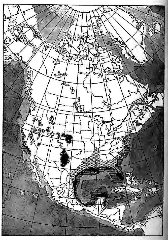
The most distinguishing feature of the Pliocene, so far as the present continents are concerned, is the predominance of terrestrial deposits. This is a consequence (1) of the exceptional deformations which took place during the period, and just before its begin n and (2) of the recency of the period, which has saved its depoe to a large extent, from removal. Similar deposits in similar amounts during and after other periods of comparable deformation, have been largely removed by subsequent erosion. These deposits of the Pliocene are perhaps most obvious in intermontane regions such as the Great Basin. They have sometimes been interprel as lacustrine deposits, and such deposits no doubt exist; but o areas much greater than those occupied by lakes in Pliocene tin and over tracts which never formed parts of well-defined flood plains, broad aprons of detritus accumulated. Such accumulations arc now most considerable at bases of mountains whose steep slopes join plains of low gradient, and where the climate is sub-arid, the rain falling in sudden and copious showers, largely concentrated on the mountain heights. The thirsty plains below, covered with porous debris, quickly drink up the descending floods and strand the detritus they bring down. Most of the western mountain America are flanked by such deposits, some of which are of Plioa age, and some younger. In lake basins, subaerial sediments nn into lacustrine, and the two may be interst ratified. The dep in question merge so insensibly into flood-plain deposits that I cannot be separated from them in all cases; nor should they since they are of the same essential nature. Pliocene deposil this type are doubtless concealed beneath later accumulate similar sort in nearly all the large basins, and at the bases of nearly all the steep slopes in the western mountain region.
[p. 829]
East of the Rocky Mountains, on the western border of the plains, deposits of this class are wide-spread. Some of them are Pleistocene, and some are probably older. In many places these gravels show by their constitution that they came from the mountains, and in some situations they have been shifted repeatedly (p. 181), always farther from the mountains and to lower levels (Fig. 555), with the result that they now constitute a series of deposits of somewhat different ages, rather than a single formation assignable to a definite epoch.
In the Mississippi basin, far from all mountains, there are patches of gravel on various hills and ridges, which are interpreted as the remnants of a once more or less continuous mantle of river detritus. The definite correlation of these gravels is not now possible, and they may not all be of the same age. They are not older than Cretaceous, and are older than the glacial drift. Their similarity to the Lafayette (Pliocene) gravels farther south suggests their correlation with that formation. The material of these gravels, almost wholly quartz, quartzite, and chert, is partly local, and partly from the north. The leading topographic features of the Mississippi basin have been developed since their deposition, for their remnants are on the crests of the highest lands within the area where they occur.
About the Atlantic and Gulf coasts similar deposition gave rise to the Lafayette (Orange Sand) formation. This formation has been so variously interpreted that it merits special consideration, and the interpretation here given it is not unchallenged.
The Lafayette Formation[1]
This formation has an extensive distribution, (1) between the Piedmont plateau and the Atlantic, (2) on the inland part of the Coastal Plain of the Gulf of Mexico, and (3) in the southern part of [p. 830]the Mississippi basin, and is represented, if our interpretation is correct, (4) in the valleys west of the Appalachians. On the Coastal Plain of Texas, the formation is connected with analogous deposits on the Great Plains, and through them with the intermontane deposits of the west, already mentioned. The term Lafayette has been usually applied only to the formation on the slope between the Appalachians and the Atlantic, about the Gulf, and in the Mississippi basin below the Ohio. Thus limited, the formation has been estimated to have an area of some 250,000 square miles. It lies upon the eroded edges of all older formations of the region, from pre-Cambrian to Miocene. It extends inland from the coast up to altitudes of 1,000 feet[2] near the Rio Grande, 800 feet in Tennessee, and 300 to 500 feet on the Atlantic slope.
[p. 831]
At its mountain-ward edge, ragged belts of the Lafayette formation follow the valleys up into the mountains, and unless our identifications are in error, they reach back with local interruptions, into the intermontane valleys. At its seaward margin, it is more or less completely concealed by younger beds, and it is not to be doubted that it passes out to sea beneath them. No part of the formation now known on land is demonstrably marine.
It is not to be understood that the Lafayette formation occurs everywhere within the general area of its distribution. Over considerable areas, it caps divides, but is absent from the valleys between them, obviously the result of stream erosion. The base on which the formation rests has but little relief, and a gentle dip seaward. It appears to have been either in an advanced stage of erosion when the Lafayette formation was deposited, or too low to have become notably rough as a result of erosion.
Thickness. In general, the formation thickens seaward; but at any given distance from the sea, it is thicker in the valleys which affected the surface on which it was deposited, and thinner on the divides between them. The known thickness ranges from 0 to 200 feet or more. Sections of 20 or 30 feet are common, and of more than 50 feet are rare.
Constitution. The Lafayette is composed of gravel (and occasionally bowlders), sand, silt, and clay, variously related to one [p. 832] another. It may be said to be both heterogeneous and homogeneous; that is, there is considerable variation in composition in short distances, and but little more in great ones. In the lower Mississippi valley, whence the name is derived (Lafayette County, Miss.) it is of sand and gravel chiefly, the coarser phases being along drainage lines where it has the distinctive characteristics of fluvial sand and gravel. Over a broad tract of the uplands east of the Mississippi and away from valleys generally, it is composed largely of silt and clay. Its constituents are largely the insoluble residues of older formations farther up the slope on which the formation lies, chert and quartz pebbles making up the gravels, and other insoluble matter the fine constituents.[3] These constituents replace one another at short intervals and in various ways, and no systematic succession is observable. Lens-like masses are not uncommon. Irregular stratification is the rule, but some portions are not bedded or laminated. Certain lenses of sand suggest an eolian origin. A singular pebble-earth that finds its analogue in subaerial and flood-plain deposits is common.
The color of the formation ranges from brick-red through various pinks, purples, oranges, and yellows, to white. The color is more irregular than the composition, bands, blotches, and mottlings diversifying the structural units.
Fossils. Fossils are rare. In its unquestioned and represent ative parts they are all of land plants and animals (except, of course, the fossils derived from earlier formations). The formation is so much dissected that it is well exposed to observation, and the rareness of known fossils is not due to lack of adequate search.
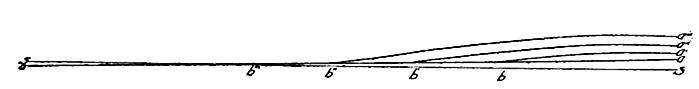
Origin. The preferred interpretation of the Lafayette formation is as follows: After the base-leveling of the region before the Comanchean period,[4] the Appalachian tract was bowed up and a new stage of degradation inaugurated. During the earlier pari of the Tertiary, a partial peneplaning of the less resistant tracts was accomplished, accompanied by relative subsidence along shore. [p. 833] At the opening of the Pliocene, the Appalachian tract is supposed to have been affected by broad, flat, intermontane valleys, mantled by a deep residual soil and subsoil. The Piedmont tract to the east is supposed to have been a peneplain near sea-level. It is assumed that the upward bowing was felt first in a relatively narrow belt along the axis of the mountain system, that the rise was gradual, and that the rising arch increased in width as time advanced. The first up-bowing rejuvenated the head waters of the streams from the mountain tract, and the surface, with its heavy mantle of residual earth, readily furnished load to the streams. When the streams reached that portion of the peneplain not yet affected, or less affected, by the bowing, they dropped part of their load (Fig. 555). With continued rise, the zone of deposition is supposed to have been shifted seaward, and the deposits already made were eroded and this material redeposited farther from the mountains and nearer the sea. Thus the process is presumed to have continued till the border of the upraised tract passed beyond the present sea-coast; after which the whole deposit within the area of the present land was subject to erosion, which had reached a notable degree of advancement before the first known glacio-fluvial deposits were laid down. A similar erosion of deposits already made, with redeposition of the materials nearer sea, would have taken place without the seaward widening of the up-arched tract.Fig. 149 shows the sequence of erosion and deposition in this latter case.
The preceding hypothesis of the Lafayette formation postulates that aggradation in each depositional zone developed a plexus of
[p. 834]
drainage lines competent to fill the shallow valleys and spread rather generally over the low divides of the coastal peneplain. In the region of deeper valleys, such as the Tennessee, the valleys were only partially filled. It has generally been assumed that the formation was once continuous east of the mountains where patches only now remain; but it may be that the higher divides, especially toward the source of supply of the sediment, were never covered by the formation.
The removal and re-deposition of material in the manner sketched above is regarded as an important part of the interpretation of the formation, and the source of grave difficulty in the correlation of it and its derivatives. The erosion and re-deposition of the material did not cease with the Lafayette epoch, but has been in progress ever since, and the derivatives so closely resemble the parent formation in structure and material that their interpretation is exceptionally difficult.
If it shall ultimately be shown that the seaward portions of the Lafayette, now concealed or unstudied, are marine, the preceding hypothesis would need to be modified only by supposing that as the feeding ground of the streams was bowed up, the coastal border of the plain was submerged. In this case, there should have been estuarine formations in the seaward valleys.
The chief alternative view relative to the origin of this formation regards it as marine[5], deposited during a stage of submergence essentially co-extensive with the area of the formation. This hypothesis has been faithfully applied by geologists of wide familiarity with the phenomena, and abandoned as untenable even where the conditions seem most to favor it. It is, however, still entertained by others. The difficulties felt by those who have abandoned it are (1) the absence of marine fossils; (2) the presence of structural features not indicative of typical marine deposits; (3) the chemical condition, particularly the high and very varying oxidation, and the meager hydration; (4) the topographic relations of the formations, especially the lack of any approach to horizontality of its upper limit; and (5) the absence of shore phenomena. The terraces and cliffs that have been appealed to in this connection, [p. 835] are local, doubtfully consistent with one another, and better explained in some other way than by the operation of waves.
Marine Pliocene Beds
The Atlantic coast. If fossils be the test, Pliocene beds of marine origin have little development on the eastern side of the continent. In Florida only (Caloosahatchie beds)[6] have beds containing marine fossils any considerable extent at the surface, though small patches are known farther north.[7] They may be parts of a continuous formation, chiefly concealed. The time relations of these marine Pliocene beds to the Lafayette are undetermined. Pliocene beds of marine origin have not been certainly identified between Florida and Texas, but they cover considerable areas farther south, as in Yucatan.
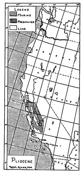
The Pacific coast.[8] Sedimentation was in progress over less extensive areas along this coast than during the Miocene period. The area of marine deposition especially was greatly restricted (Fig. 556. Compare Fig. 543). The marine deposits are chiefly of fine clastic sediments, while the non-marine deposits contain more coarse material. The maximum known thickness of the marine Pliocene is found south of San Francisco, where about 4,000 feet of strata (Merced series) are exposed.[9] The non-marine part of the system (Paso Robles formation) is about three-fourths as thick in the San Joaquin valley.
Crustal Movements of the Pliocene[10]
The tendency to crustal movements, both warping and faulting, which had characterized the western part of the continent since the close of the Mesozoic, seems to have continued at least intermittently [p. 836] through the Pliocene, though the movements which tool| place during the period are not always distinguishable from those
of earlier and later times. Deforming movements often extend through long periods, and the Pliocene movements were in many places probably no more than continuations of those begun earlier.
About the close of the period, movements were extensive and great, resulting in increased height of land. The interval of active erosion which followed is sometimes known as the Ozarkian or Sierran epoch.[11] The region covered by the Lafayette formation was somewhat higher than now, and in reaching this position, was perhaps somewhat deformed. The coast line was probably farther east than now, perhaps at the e of the continental shelf, across which streams may have flowed. To this epoch, the submerged continuations of the St. Lawrence, the Hudson, the Delaware, the Susquehanna, and the Mississippi are commonly referred. Some of these submerged valleys have great depth, and it has been assumed that their depth was a measure of the elevation of the land when they were excavated. But if the considerations set forth in Chapter XXXI have force, it is not necessary to postulate BUeh extraordinary changes of level by uplift and depression. Continental [p. 837] creep along the slope between the continental platforms and the ocean basins may have lowered the valleys notably as it carried them seaward. The earlier assumption that the land along the Atlantic seaboard must have stood 2,000 to 3,000 feet, or perhaps even 7,000 to 12,000 feet[12] above its present level to allow the excavation of these valleys, may be quite unnecessary, even if the valleys in question are merely submerged river valleys. (See p. 294, and Chapter XXXI).
In the Mississippi basin there was also notable elevation at this time, though probably less than has sometimes been estimated. It seems possible, or perhaps even probable, that the evolution of the principal physiographic features of the interior, so far as due to erosion, began with the Ozarkian epoch, though the study of the evolution of the topography of this region has not advanced so far as to make this conclusion certain.
In the west, too, there were notable closing-Tertiary movements. The plateau region was in process of uplift, periodically, throughout the Tertiary, during which it has been estimated to have undergone an elevation of 20,000 feet (Dutton), and a degradation of 12,000, leaving it 8,000 feet above sea-level. How much of this is assignable to the Sierran epoch is uncertain. It was Dutton’s view that the Colorado plateau was so elevated at this time as to rejuvenate the Colorado River, and that the cutting of its inner gorge some 3,000 feet (maximum) below the outer (p. 137), was the work of later times. More recent studies indicate that even the outer and broader part of the valley is younger than was formerly thought, perhaps post-Sierran, and raise a question as to whether the inner gorge is not the result of rock structure, rather than of a distinct and later uplift.[13] If the whole of the canyon is postSierran, the elevation of the region in the Sierran epoch (and later) must have been several thousand feet. The later elevations, largely by blocks, were so recent that the fault scarps are almost always distinct, and independent of stratigraphy and drainage.[14]
[p. 838]
In the basin region, faulting and deformation[15] gave rise to depressions between the Sierra Nevada and the Wasatch Mountains, preparing the way for two great Pleistocene lakes (Bonneville and Lahontan). It is probable that many other faults between the Rockies and Sierras were developed at the same time, and in many cases the movement seems to have been along fault planes established earlier.
In the Sierra region, the post-Tertiary (or late Tertiary?) uplift was still more marked.[16] Not only the deep canyons of these mountains, but all the scenery of the high Sierras is post-Tertiary. “Its bold, rugged, savage grandeur is due to its extreme recency. The wildness of youth has not been tempered and mellowed by age.”[17] The beginning of the re-elevation of the Sierras, after peneplanation, is usually placed in late Miocene time.
Still nearer the Pacific, notable changes marked the transition to the Pleistocene. In some parts of southern California (Los Angeles County) marine Pliocene beds are said to occur up to altitudes of 6,000 feet,[18] and in others (San Luis Obispo), there was folding (Fig. 545) and faulting, while the shore-line was pushed out toward the edge of the continental shelf.[19] There are submerged valleys[20] along the Pacific coast, as along the Atlantic, but their excavation, instead of following the Ozarkian uplift, has been referred to a somewhat earlier time. Some of these valleys differ from those of the Atlantic coast, in not being the continuations of existing land valleys. The late Pliocene movements and lava flows, the latter filling many of the valleys, are thought to have so disturbed the drainage that the streams no longer reached the sea by their former courses.
In Washington, present knowledge points to the early Pliocene as a time of prolonged erosion. The crests of the Cascade Mountains seem to represent remnants of a deformed peneplain, which, carried to the east and south, is continuous with an erosion plain [p. 839] which cuts across strata (Ellensburg formation) of late Miocene[20:1] age. The planation must, therefore, have been later than that part of the Miocene period represented by the Ellensburg formation. At least the early part of the Pliocene period, if not most of it, would seem to have been necessary for the accomplishment of this great planation, so that the peneplain can hardly be thought to antedate late Pliocene time. If this is correct, the main features of the present topography of this rugged region are the result primarily of Pleistocene erosion on the peneplain uplifted and deformed in, or subsequent to, late Pliocene time, and secondarily of vulcanism, which has built up the great volcanic piles (Rainier) and others) which affect the region. In British Columbia also, the Pliocene is thought to have been primarily a time of erosion.
Deformative movements of the orogenic type seem not to have been common at the close of the Pliocene, but such movements affected the Santa Cruz Mountains of California, where Miocene (Monterey) and Pliocene (Merced) beds were deformed together.[21]
On the whole, the close of the Pliocene must be looked upon as a time of great deformation, a critical period in the history of North America. New lands were made by emergence from the sea, and old lands were deformed and made higher; new mountains were made, and old ones rejuvenated; streams were turned from their courses in some places, and nearly everywhere started on careers of increased activity. The fact that such notable changes, with increased elevation of land, occurred during the epoch next preceding the glacial period, is one of the considerations which led to the once wide-spread belief that the elevation was the cause of the climate of the latter period. While there may be a connection between the two things, it was probably not in the simple and commonly accepted sense.
The volcanic activity of preceding periods continued into the Pliocene, and became somewhat pronounced near the end of the period in different parts of the western Cordillera. Some of the late igneous formations of the Sierras, and perhaps of northern [p. 840] California,[22] belong to this time, and probably some of those of nearly or quite every other state west of the Rocky Mountains. Many of the prominent volcanic peaks of the west date from this time, or later, and represent the later phases of the prolonged period of volcanic activity, just as the great lava flows and intrusions represent the earlier. Many lesser cones belong to the same period.
Foreign
From considerable areas of Europe covered by water during the Miocene, the waters retreated late in the period or at its close; but the sea covered southern and southeastern England, Belgium, and parts of France during at least some portion of the Pliocene, and still more extensive areas of the present continent about the Mediterranean. Beyond the inland margins of the marine Pliocene, there are contemporaneous beds of terrestrial origin. In southeastern Europe, brackish and salt lakes came into existence, as shown by the fossils and the local deposits of salt and gypsum. In some places, as in the Vienna basin, brackish water beds below grade up into fluviatile beds above.
In Italy only do Pliocene beds attain massive development. Along the Apennines, their thickness has been variously estim:; at from 1,600 to 3,000 feet, and in Sicily 2,000 feet. Limestone as well as clastic beds enter into the system, and occur up to heii of 3,000 feet.
Marine Pliocene is known in Egypt, where the sea is thought to have extended up the Nile to Assuan. The formation of the bas (rifts) of the Red Sea and the Gulf of Suez, has been assigned to this period, though the rift origin of these depressions has not 1 < accepted universally.
¶ The Life of the Pliocene
The land plants. During the Pliocene there was a further ing out of the mixed flora of previous periods, and the south migration of what are now tropical and subtropical plants continued. In southern France there were species identical with those [p. 841] now living in the Canaries. In Europe generally there was still much commingling of species now separated geographically. Some of this later separation is in longitude, and does not carry climatic suggestiveness. The evidence, on the whole, points to a general movement in latitude, in anticipation of the present distribution and adaptations of the plants.
The land animals. The history of the mammals continued to be the great center of interest. Three important features characterized it: (1) A notable intermigration of the continental faunas, including those of North and South America; (2) the initiation of the present divergence between Old and New World types; and (3) the culmination and perhaps initial decline of the placentals, the human and domestic species aside.
The intermigration of the early part of the period was a consequence of the land connections, not yet worked out in detail, brought about by deformative movements. The extent of the connection of North America with Eurasia at the northwest and northeast respectively is uncertain, but the evidence of good migratory routes for the land mammals during a portion of the period may be accepted as conclusive. There are also strong hints of the existence of a connection which afforded passage for some species, but not for others. The prohibition was perhaps the increasing cold in the later stages of the period, leading up to the glacial period which followed. The increasing cold, with its effect on intermigration, was perhaps the chief factor in developing the difference between the mammals of the Old World and the New.
The connection between North and South America introduced a biological movement of dramatic interest. There appears to have been no effective isthmian thoroughfare for land animals between the earliest Eocene and the Pliocene, when a way was opened. During the Eocene connection, a few North American mammals seem to have sent representatives into South America, and these had evolved on distinctive lines in the interval. A remarkable group of sloths, armadillos, and ant-eaters had developed from an edentate, stem; strange hoofed animals of orders unknown elsewhere (Typotheria, Toxodontia, Litopterna) had arisen from some very primitive ungulate form; monkeys of the South American [p. 842] type had evolved probably from a North American Eocene lemuroid, while rodents of the porcupine type had been derived from some unknown immigrant. That the connection of the continents in the Eocene was only partial or temporary, seems to be implied by the absence in South America of most of the great North American groups (creodonts, carnivores, condylarths, artiodactyls, peri dactyls, and insectivores) . The absence of proboscidians implies a lack of connection between South America and Africa, where these forms developed during the Eocene and Miocene. Many carnivorous and herbivorous marsupials, similar to those of Australia, lived at this time in South America, implying either connection in that direction, or striking parallel evolution. The remarkable South American mammalian fauna is a striking instance of evolution on a large scale in comparative isolation, and in relative freedom from the severe stimulus of effective competition, powerful carnivores, and shifting geographic relations.[23]

When connection between the two Americas was made in Pliocene time, the fauna of each continent invaded the other. Horses, mastodons, deer, carnivores, llamas, and tapirs, from the north went to South America, while gigantic sloths from the south came to our continent, but did not maintain themselves long.
The herbivores continued to occupy the foremost place among mammals. Both the odd- and even-toed ungulates completed [p. 843] their deployment into present orders, and very generally into present genera. They were also represented by many genera and species which are now extinct. A list of Pliocene families would be little more than a catalogue of living ones. The evolution of the horse was advanced to the existing genus Equus. Giraffes and giraffe-like animals, some of them of great size, invaded southern Europe and Asia, coming probably from Africa.
The giants of the period were the proboscidians. The extinct Dinotherium was widely distributed in Europe and has been found in India, but is not known to have reached America. Mastodons seem to have occupied all the continents, but it is doubtful whether the elephant reached America before the Pleistocene. They appear to have flourished in Europe, and with the associated rhinoceroses and hippopotamuses, gave to the European fauna an African aspect.
The carnivores of both continents throve and perhaps gained on the herbivores; at any rate they put a severe tax on the herbivores, forcing further progress in the line of alertness, sagacity, speed, and defense, and gaining similar qualities themselves. The rodents appear to have held about their present place relatively.
[p. 844]
Supreme interest attaches to the development of the primates, but the data on this point are likely to remain limited until the tropical regions of the Old World are more fully studied, for the chief evolution of this group seems to have taken place there. No remains of lemuroids or of their descendants have been found in the Pliocene of North America. Those of Europe are from the middle and southern parts of the continent, a limitation which probably implies that northern Europe was already too cold for these animals.
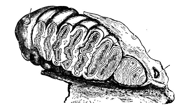
The most interesting discovery of recent date is that of the remains of a man-like skeleton in Java, and named Pithecanthropus erectus. The relics include the roof of a skull, two molar teeth, and a femur. The form of the femur indicates that its possessor walked erect. The forehead was low and the frontal ridge prominent, [p. 845] and in general the characteristic features were intermediate between those of the lowest men and the highest apes, as shown in Fig. 559. The size of the brain was about two-thirds that of an average man. The interpretation of this find has elicited much difference. of opinion. By some the bones are thought to be those of an abnormal man; by others, those of an ancestral type between man and his more remote ancestry.
The marine life. The record of marine life on the Atlantic coast of America is extremely meager. The few forms which have been found in southern New England (Gay Head, Sankoty Head) show that species which then ranged from Bering Sea to the north Atlantic, are now confined to temperate latitudes.[24] On the coast of California the early Pliocene faunas indicate a temperature lower than that of the Miocene, while the later Pliocene faunas point to sub-boreal conditions.[25] On the other hand, Pliocene fossils from Alaska (vicinity of Nome) indicate for this locality, when the beds containing these fossils were deposited, a climate similar to that of north Japan and the Aleutian Islands, where the sea remains unfrozen, though Nome has now a sub- arctic climate. Similarly Pliocene fossils from the northwest Goast of Iceland indicate a temperature no colder than 42° (mean) where conditions are now arctic.[26] The apparent lack of harmony between the phenomena of California and higher latitudes may perhaps be due to the different horizons from which the fossils come.
Certain fossils of Japan and California indicate intermigration, or migration from a common center, sometime during the period.
Map work. Many of the folios mentioned on pp. 726 and 771 afford good sections of the Tertiary formations. In addition, the following folios may be mentioned: Arizona, Bradshaw Mountain; Colorado, Ouray; Georgia, Rome; Idaho, Boise, Silver City; Kentucky, Richmond; Maryland, Patuxent; Nebraska, Camp Clarke, Scott’s Bluff; Washington, Tacoma, Ellensburg, Mt. Stuart, Snoqualmie; West Virginia, Huntington.
¶ Notes
The fullest sketch of this formation as a whole is that of McGee in the Twelfth Annual Report of the U. S. Geological Survey. A few references to other accounts of the formation in special localities, often under other names, are as follows: Safford, Am. Jour. Sci., Vol. XXXVII, 1864; Hilgard, Agric. and Geol. of Miss., 1860, and Am. Jour. Sci., Vol. XLI, 1866, and Vol. IV, 1872; Salisbury, Geol. Surv. of Ark., Report on Crowley’s Ridge, 1889; Durable, Jour. Geol., Vol., II, 1894, p. 560; Smith, E. A., and Johnson, L. C, Geol. Surv. of Ala., 1894. ↩︎
McGee, loc. cit. ↩︎
Hilgard, Am. Jour. Sci., Vol. IV. p. 266, Ld72. ↩︎
Rivers of Pennsylvania, and Geographic Development of Northern Vu Jersey, Nat. Geo. Mae., Vol. I and Vol. II. respectively. Hayes, chapter an the southern Appalachians, in Physiography of the United States. ↩︎
McGee, 12th Ann. Rept., U. S. Geol. Surv. ↩︎
Dall, Am. Jour. Sci., Vol. XXXIV, 1887, p. 161, Wagner Free Inst, of Science, Vol. XIV, pt. VI, p. 1604, Bull. 74, U. S. Geol. Surv. ↩︎
Dall, Trans. Wagner Free Inst, of Sci., Vol. Ill, Pt. II, pp. 201-217, 1892. ↩︎
Arnold, Ralph, Jour. Geol., Vol. XVII. ↩︎
Lawson, Science, Vol. XV, 1902, p. 410, and Hershey, Am. Geol., XXIX, p. 359, give the Pliocene of California greater thicknesses. ↩︎
LeConte, Am. Jour. Sci., Vol. XXXII, p. 167, 1886, Bull. Geol. Soc. Am., Vol. II, p. 329, Jour. Geol., Vol. VII, p. 546, 1899; Hershey, Science, Vol. III, p. 620, 1896; McGee, 12th Ann. Rept., U. S. Geol. Surv., and Science, Vol. Ill, p. 796; also King, op. cit., and Dutton, Mono. I, U. S. Geol. Surv. ↩︎
Hershey, Science, Vol. Ill, p. 620, 1896, and LeConte, Jour. < VII, p. 529. ↩︎
LeConte, op. cit., and Spencer, Am. Jour. Sci., Vol. XIX, 1905. ↩︎
Huntington and Goldthwaite, Bull. Mus. Comp. Zool. Geol. Ser., Vol. VI, p. 252; and Davis, ibid., Vol. XXXVIII. ↩︎
Huntington and Goldthwaite, op. cit., p. 248. ↩︎
King, U. S. Geol. Expl. of the 40th Parallel, Vol. I, p. 542. ↩︎
LeConte, op. cit., and Diller, 14th Ann. Rept., U. S. Geol. Surv. ↩︎
LeConte, Jour. Geol., Vol. VII, pp. 529-530. * Hershey, Am. Geol., Vol. XXIX, p. 364. ↩︎
Fairbanks, San Luis folio, U. S. Geol. Surv. ↩︎
LeConte, Bull. Geol. Soc. of Am., Vol. II, p. 325. ↩︎
Smith, Ellensburg, Wash., folio, U. S. Geol. Surv.; and Willistand Smith, Professional Paper 19, U. S. Geol. Surv. ↩︎ ↩︎
Ashley, Jour. Geol., Vol. Ill, p. 434. ↩︎
Hershey, Jour. Geol., Vol. X, pp. 377-392. ↩︎
Reports of the Princeton University expedition to Patagonia 1896-99. ↩︎
Dall, Jour. Geol., Vol. XVII. ↩︎
Arnold, Ralph, Jour. Geol., Vol. XVII. ↩︎
Dall, loc. cit. ↩︎