Public domain
[p. 394]
The general method by which rocks are formed has been set forth in previous chapters, and many of their structural features have been touched upon. It remains to assemble the structural features already mentioned and to note certain additional ones.
Sedimentary Rocks
Stratification. Sedimentary rocks are usually arranged in more or less distinct layers; that is, they are stratified. Stratification consists primarily in the superposition of layers of different constitution or compactness, on one another; but layers of like constitution or compactness are often separated by films of different material which cause the partings between them. The bedded arrangement of stratified rocks is due to various causes, but primarily to the varying agitation of the waters in which the sediment > were laid down. Where the depositing waters are agitated to the bottom, coarse sediment only is likely to be deposited. Where the waters are quiet at the bottom, fine sediment is the rule. Since the agitation of the waters is subject to frequent change, coarser material may succeed finer, and vice versa, in the same place. Hence arise beds, layers, and laminae. The terms layer and bed are generally used as synonyms, while laminai are thinner divisions of the same sort. The term stratum is sometimes applied to one layer, and sometimes to all the consecutive layers of the same sort of rock. For the latter meaning the term formation is often used.
In some cases bedding seems to have been determined by si rong currents which temporarily not only, prevented deposition over a given area, but even cut away the loose surface of deposits already made, giving a firm surface from which succeeding deposits are [p. 395] distinct. This sequence of events is sometimes shown by the truncation of lamina?, and by other signs of erosion. The commoner sorts of bedded rock are limestones, shales, sandstones, and conglomerates.
The bedding of limestones is often caused by films of clayey material between the layers of limestone, the films causing natural partings. Sometimes, however, bedding arises from variations in the physical condition of the calcareous sediment itself. Lamination is not usually conspicuous in pure limestone, though it may be well developed in. the shaly phases of this rock. Shales are normally laminated as well as bedded, and the lamination is often more notable than the thicker bedding. Bedding in shale may arise from the introduction of sandy laminae, or by changes in the texture of the mud, earth, clay, etc., of which the shale was made. Sandstones are sometimes divided into beds by shaly or clayey partings, but quite as often by variations in the coarseness of the sand itself, or by the presence of laminae or layers that are less coherent than those above and below. Sandstones may be thick or thin-bedded and their bedding passes insensibly into lamination.
[p. 396]
Sand is usually deposited in relatively shallow water where it is subject to much shifting before it finds a permanent lodgment. In the course of this shifting, bars or reefs are formed which usually have a rather steep face in the direction in which they are being shifted. The sand carried over the top of the bar finds lodgment on the sloping face opposite. The inclined laminae thus formed constitute a kind of bedding, but since its planes do not conform to the general horizontal attitude of the formations as a whole, it is called false or cross-bedding, or, more accurately, cross-lamination (Fig. 303). The same structure is developed on delta fronts, and generally in water shallow enough to be subject to frequent agitation at the bottom. Sandstone is cross-bedded more commonly than shale or limestone. The bedding of conglomerate is due chiefly to variations in coarseness, and laminae or beds of sand often occur between the layers of coarser material. Conglomerate is often thick-bedded, and cross-bedding is common.
Lateral gradation. When the varying nature of the agitation of the sea at different depths and along the different parts of a coast is considered, it will be understood that deposits of one kind may grade into others horizontally. Thus a bed of conglomerate (gravel) may grade laterally into sandstone (sand), and this into shale (mud) or limestone. It is indeed more remarkable that sedimentary strata are as regular and persistent as they are, than that they sometimes grade into one another.
Special markings. The rhythmical action of waves gives rise to undulatory lodgment, known as ripple-marks (Fig. 263). They are usually not the direct product of the surface-waves, as shown by the fact that they are much smaller than these waves. They are sometimes made by streams and stream-like currents. Under proper circumstances, ripple-marks are preserved indefinitely. Ripple-marks are also made by wind (Fig. 61). They are usually [p. 397]
only a few inches from crest to crest, but in rare instances they attain much greater size, examples 30 feet across being known.[1] Occasional ridges and depressions of much greater dimensions are produced which are attributable to the formation of successive bars, or to the building of wave-cusps.[2] Rill-marks are not infrequently produced by the undertow and other currents passing over pebbles, shells, etc. (Fig. 264).
Sediments are sometimes exposed between tides, or under other circumstances, for periods long enough to permit drying and cracking at the surface. On the return of the waters, the cracks may be filled and permanently preserved. These are known as sun-cracks or mud-cracks (Figs. 267 and 268). They affect shales chiefly, but are occasionally seen in limestones and fine-grained sandstones. During the exposure of the sediments, a shower may pass, and raindrop impressions (Fig. 304) be made which are subsequently filled by fine sediment and preserved.
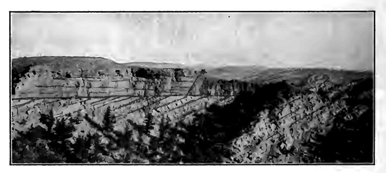
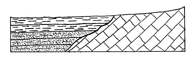
Uncomformities. In Figs. 305, 306, and 307, one set of bed is seen to be out of harmony with another set. This relation is one [p. 398] of unconformity. An unconformity is developed by the erosion, the deformation, or both, of the older and lower set of beds before the deposition of the younger and upper set. The interval of time between the deposition of the two unconformable sets of beds may be very long — when the unconformity is said to be great, or short — when the unconformity may be slight. Unconformities are often of great significance in the interpretation of geological history.

[p. 399]
There may be unconformities between stratified rock and igneous rock, and between stratified rock and metamorphic rock, as well as between different series of bedded rocks.
Igneous Rocks
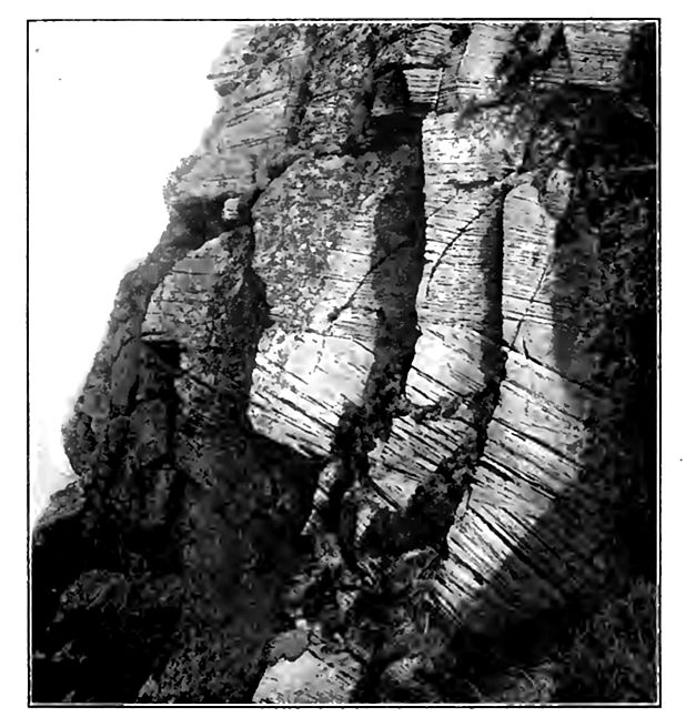
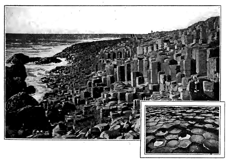
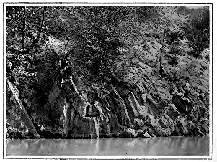
Certain large structural features of igneous rocks have been mentioned in treating of their origin in the previous chapter. When a great flow of lava spreads out upon the surface, there is [p. 400] no internal lamination or stratification, and the resulting rock is usually classified as massive rather than stratified; but when a succession of flows occurs, each individual flow forms a layer, and the series as a whole becomes stratiform. The successive flows are not usually co-extensive. If the later flows of the closing stages of a period of vulcanism fail to reach as far as the earlier ones, a terrace or step-like aspect is given to the region, whence the name trap-rock ((trappe, steps) is derived. Such lava sheets, especially if of basalt, often assume a columnar structure in cooling, the columns being rude six-sided prisms standing at right angles to the cooling surfaces (Figs. 8 and 308). This phenomenon is sometimes well developed in sills (p. 15). The formation of the columns is sometimes regarded as a variety of concretionary action, but more commonly as a result of contraction (p. 17). The various structural forms due to intrusions of lava have been enumerated (p. 367).
Metamorphic Rocks
The conspicuous structural feature of metamorphic rocks is their schistosity (p. 14). Crumpling has followed the development of the schistose structure in many cases. Slaty cleavage, which represents incipient metamorphism, has been referred to (p. 53), as have the causes which produce metamorphism.
Features Arising from Disturbance
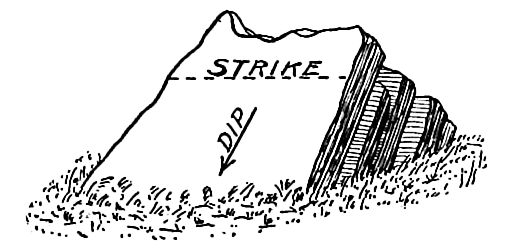
Inclination and folding of strata. The original attitude of beds, whether formed by water or by lava-flows, commonly departs but little from horizontality. Both kinds of deposits, however, occasionally take place on considerable slopes. Modifications of the 'original attitude result from earth movements, and the measurement of these modifications is an important feature of field study. The position of beds is recorded in terms of dip and strike. The dip is the inclination of the beds referred to a horizontal plane, as illustrated in Fig. 309, and is usually measured by a clinometer, shown in Fig. 310. In measuring the dip, the maximum angle is always taken. The direction as well as the amount of the dip is to be noted. Thus dip 40°, S. 20° W., gives the full record of the position of the bed of rock under consideration. The strike is [p. 401] the direction of the horizontal edge of dipping beds, or more generally, "the direction of a horizontal line along the outcropping edge of a dipping bed, as illustrated in Fig. 309. Since the strike is always at right angles to the dip, the strike need not be recorded if the direction of the dip is. Thus dip 40°, S. 20° W. is the same as dip 40°, strike N. 70° W.

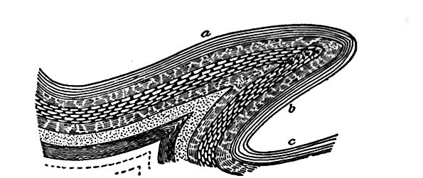
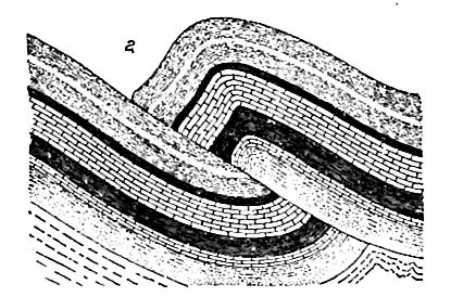
When beds incline in a single direction, they form a monocline. When they are arched up as in a fold, they form an anticline (Figs. 16 and 17). The anticline may depart from its simple form, as shown in Fig. 311. The downfold corresponding to an anticline is a syncline (Fig. 312). When beds assume the position shown in Fig. 18, the folds are isoclinal. When considerable tracts are bent so as to form great arches or great troughs with many minor undulations on the flanks of the larger, they are called geanticlines, or anticlinoria (Figs. 286 and 313), and geosynclines or synclinoria (Fig. 314). Folding is often accompanied by the development of slaty cleavage (p. 53).
[p. 402]
[p. 403]
Fig. 314. — Synclinorium, Mt. Greylock, Mass. (Dale, U. S. Geol. Surv.)
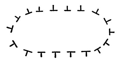
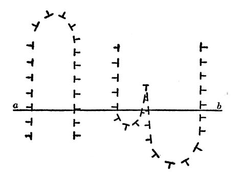
As found in the field, folds are usually much eroded, and often completely truncated (Fig. 313). The structure is then determined by a careful record of dips and strikes. On the field map, the record may be made as shown in Figs. 315 and 317, where the free ends of the lines with but one free end, point in the direction of dip, while the other lines represent the directions of strike. Applying this method, the structure shown in Fig. 315 represents a syncline, and that in Fig. 317 an anticline. In cross-section, the structure presented by Fig. 315 would appear as in Fig. 316.Fig. 319 shows a doubly plunging anticline; that is, an anticline the axis of which dips down at either end.Fig. 320 shows a combination of synclines and anticlines, and Fig. 321 a cross-section along the line ab of Fig. 320. The outcrops of rock where the dip and strike can be determined may be few and far between, but when they are sufficiently near one another, the structure of the rock, as shown in Fig. 320, may be worked out, even though the surface is flat.
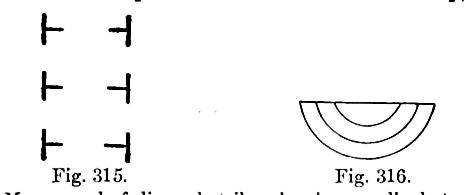
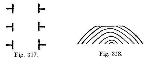
Fig. 317. — Map record of dip and strike showing anticlinal structure.[Fig. 318](#Figure_318). — The structure of the area shown in [Fig. 317](#Figure_317), in cross-section.
[p. 404]
[p. 405]
Much the larger portion of the earth’s surface is occupied by beds that depart but little from their original horizontal attitude, but in mountainous regions the beds have usually suffered bending, folding, crumpling, and crushing, in various degrees, in the course of the deformations that gave rise to the mountains. Distortion is on the whole most intense and characteristic in the most ancient rocks. Distortion is assigned chiefly to lateral thrust arising from the shrinkage of the earth, as explained in Chapter IX.

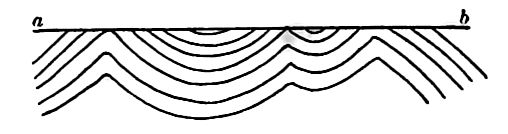
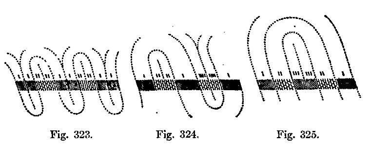
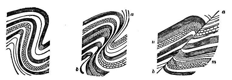
Complicated structures may be very difficult of interpretation. Thus overturned folds reverse the order of the strata in the under limb of the fold (Fig. 311). After such folds have been greatly eroded, so that their outer form is lost and their relations have become obscure, the reversed beds are likely to be interpreted as though they lay in natural order. In such a case as that represented in Fig. 322, a complex structure may be interpreted as a simple one. Thus these strata may have the structure shown in Fig. 323, 324, or 325, so far as dip and strike show.
[p. 406]
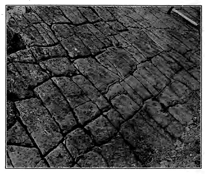
Joints. The surface rocks of the earth are almost universally traversed by deep cracks called joints (Figs. 2 and 327). In most regions there are at least two systems of joints, the crevices of each system being roughly parallel to one another, while those of the two systems, where there are two, are approximately at right angles. In regions of great disturbance, the number of sets of joints is often three, four, or even more. The joints of each set may be many yards apart, or in exceptional cases, but a few inches, or even a fraction of one inch.
[p. 407]
In undisturbed rocks the joints approach vertically, but in regions, where the rocks have been notably deformed, the joint planes may have any position. In igneous and metamorphic rocks they may simulate bedding planes (Fig. 328) . Joints do not ordinarily show themselves at the surface in regions where there is much mantle rock, but they are readily seen in the faces of cliffs, in quarries, and, in general, wherever rock is exposed. Though some of them extend to greater depths than rock has ever been penetrated, they are believed to be relatively superficial phenomena. They must be limited to the zone of fracture, and most of them are probably much more narrowly limited. Joints frequently end at the plane of contact of two sorts of rock. Thus a joint extending down through limestone may end where shale is reached. Joints are frequently offset at the contact of layers or formations, and a single joint sometimes gives place to many smaller ones. All these phenomena may be explained by the varying elasticity of various sorts of rock. Generally speaking, rigid rock is more readily jointed than that which is more yielding.

Joints may remain closed, or they may gape. They may be widened by solution, weathering, etc., and they may be filled, [p. 408] partly or wholly, by detritus from above, or by mineral matter deposited from solution (veins) . Many rich ore- veins are developed along joint-planes.
Joints have been referred to various causes, among which tension, torsion,[3] earthquakes,[4] and shearing[5] are the most important. Most of them may probably be referred to the tension or compression connected with crustal movements.[6] In the formation of a simple fold, for example, tension-joints parallel with the fold will be developed if tension goes beyond the limit of elasticity of the rock involved. If the axis of a fold is not horizontal, that is, if it “plunges,” as it commonly does, a second set of tension-joints roughly perpendicular to the first may be developed. If the uplift is dome-shaped and sufficient to develop joints, they will radiate from the center. It is true that joints affect regions where the rocks have not been folded, and where they have been deformed but little, but deformation to some extent is well-nigh universal.
[p. 409]
Shrinkage is a cause of certain minor tension-jointing. The columnar structure of certain lavas, and the cracks developed in mud when it dries, are examples. These causes, however, are not believed to affect rock structures to great depths.
Exceptionally, open joints are filled by the intrusion of sedimentary material from beneath. Thus have arisen the remarkable sandstone dikes[7] of the West, especially of California. Such dikes are sometimes several miles (nine at least) in length. The sand of these dikes was forced up from beneath either by earthquake movements of by hydrostatic pressure.
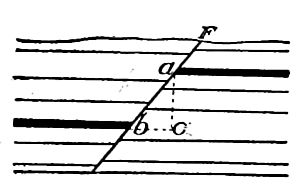
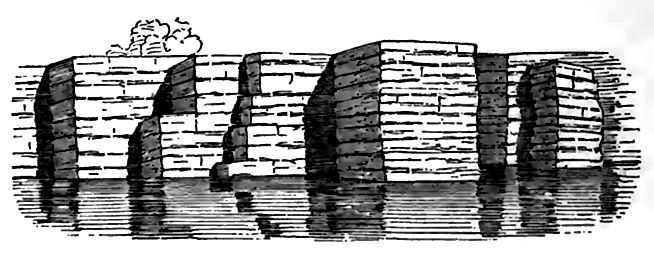
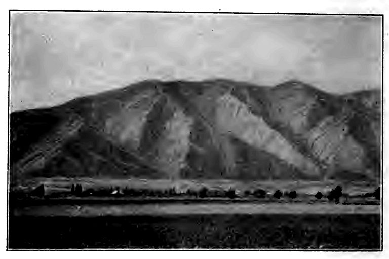
Faults.[8] The beds on one side of a joint-plane or fissure are sometimes elevated or depressed relative to those on the opposite side. Such a displacement is one type of a fault (Figs. 33 and 34) . Joint-planes and fault-planes may vary from verti cality to approximate horizontality. The angle by which the fault-plane departs from a vertical position is known as the hade (bac, Fig. 330). The vertical displacement (ac) is the throw, and the horizontal displacement (be) the heave. The heave and the throw are to be distinguished from the displacement, which is the amount of movement along the fault-plane (ab,Fig. 330). The cliff above the edge of the downthrow side is a fault-scarp. In many, probably in most cases, the scarp has been destroyed, or at any rate greatly obscured by erosion; but occasional fault-scarps of mountainous heights are found, as along the east face of the Sierras and along many of the basin ranges of Utah and Nevada. As a rule, they are much modified by erosion (Fig. 331).
[p. 410]
The rock on either side of a fault-plane is often smoothed as the result of the friction of movement. Such surfaces are slicken-sides. A slickenside surface has some resemblance to a glaciated surface, but is generally more glazed.
Faults involving vertical displacement along joints are of two general classes, normal (or gravity) and reversed (or thrust). In the normal fault (Fig. 330) the overhanging side is the downthrow side, i. e., the downthrow is on the side towards which the faultplane declines, as though the overhanging beds had sliddcn down the slope. Normal faults, as a rule, indicate an extension of st rat a, this being necessary to permit the dissevered blocks to settle downwards. In the reversed fault (Fig. 34), the overhanging beds appear to have moved up the slope of the fault-plane, as though the displacement took place under lateral pressure. This is clearly shown to be the case where an overfold passes into a reversed fault (Fig. 332). Another type of thrust-fault is shown in Fig. 333.
[p. 411]
In thrust-faults, the heave is often great. The eastern face of the Rocky Mountains near the boundary-line between the United States and Canada has been pushed over the strata of the bordering plains to a distance of at least seven or eight miles.[9] Overthrusts of comparable displacement have been detected in Scotland,[10] and elsewhere.
Sometimes a fault branches, and sometimes the faulting is along a series of parallel planes near one another,[11] instead of being along a single plane. Such a fault is distributive (Fig. 37).
Faults are found to die out when traced horizontally, sometimes [p. 412] by passing into monoclinal folds (Fig. 38), and sometimes without connection with folding. In depth they probably die out in similar ways in most cases. A fault of thousands, or even hundreds of feet is probably the sum of numerous slight slippings distributed through long intervals of time. The faulting along one plane may be the cause of many earthquakes.
The significance of normal and reversed faults.[12] Faults afford an indication of the conditions of stress and tension to which a region has been subjected, but some caution must be exercised in their interpretation. Normal faults usually indicate an extension of the surface sufficient to permit the fault-blocks to settle down unequally. Reversed faults usually signify a compression of the surface which required the blocks to overlap one another more than before the faulting. In other words, normal faulting usually implies tensional stress, and reversed faulting compressional stress. There may be cases of normal faulting in a region of compressed and folded strata, and reversed faults in regions of tension; but such cases are exceptional and usually local. These exceptional cases aside, the general inference from prevailing normal faults is that the regions where they occur have undergone stretching, while the inference from the less widely distributed thrust faults is that the surface where they occur has undergone compression.
In view of the current opinion that the crust of the earth has been subjected to great lateral thrust as a result of cooling, it is well to make especial note of the fact that the faults which imply stretching are called normal because they are the more abundant; and that the faults which imply thrust are less common, and are styled reversed. The testimony of normal faults in favor of tension is supported by the prevalence of gaping crevices, and of veins which are but crevices that stood open until filled by deposition. All these phenomena seem to testify to a stretched condition of the larger part of the surface of the continents.
Faulting may bring about numerous complications in the outcrop of rock formations, as already illustrated (pp. 65-67).
Faults of horizontal displacement. The preceding discussion has concerned faults which involve more or less vertical displacement [p. 413] along joint planes, but faulting is not limited to such displacements. • Horizontal displacements may take place along a joint plane, with no vertical displacement, and this also is faulting. Horizontal displacement often accompanies vertical displacement, and the former is as much a part of the faulting as the latter is. The tendency of recent study, whether based on theory or on field observation, is to emphasize the importance of the horizontal movement in faulting. In numerous mines, for example, where the walls of the shafts and tunnels afford excellent opportunity for determinations, horizontal movement is much more in evidence than vertical.
There are various displacements of rock bodies not mentioned above which are akin to faulting, if not to be regarded as such. Thus when strata are folded there is some slipping of layer on layer. Occasionally there is displacement of layer on layer, even when the beds are not folded. Such a case with a well developed “slicken-side” surface is known in Ohio, between beds which are nearly horizontal. The recognition of such movements as faults opens a wide door. The great variety of displacements along joints or other partings in the rock, shows the difficulty of defining faults sharply. Many movements of displacement, which can hardly be separated from faults logically, are not usually called faults.
Map work. The sections of the Structure Section Sheets of the folios of the United States Geological Survey furnish abundant illustrations of a variety of structural features, such as folding and faulting, and the relations of sedimentary, metamorphic, and igneous rocks. The sections of various Bulletins, Professional Papers, etc., of the same Survey afford other illustrations.
¶ Notes
Gilbert, Bull. Geol. Soc. Am., Vol. X, 1898, pp. 135, 140. ↩︎
Branner, Jour. Geol., Vol. VIII, 1900, pp. 481-484. ↩︎
Daubree. Geologie d’Experimentale, Tome 1, pp. 306-372. ↩︎
Crosby. American Geologist, Vol. XII, 1893, pp. 368-875. ↩︎
Becker. Bull. U. S. Geol. Surv., Vol. X, pp. 41-75. G. B. A., VoL I V. ↩︎
Van Hise. Principles of North American Pre-Cambrian Geology; 16th Ann. Rept., U. S. Geol. Surv., Pt. I, pp. 668-672. ↩︎
Diller. Bull. Geol. Soc. Am., Vol., I, pp. 441-442. Ibid., Hay, Vol. Ill, pp. 50-55; and Newsom, ibid., Vol. XIV, pp. 227-268. ↩︎
Chamberlin. Economic Geology, Vol. II, pp. 585 and 704. ↩︎
Willis, Bull. Geol. Soc. of Am., Vol. XIII, pp. 331-336, and McConnell, Canada Geol. and Nat. Hist. Surv., 1886, Pt. II. ↩︎
Geikie, Text-book of Geology. ↩︎
Becker, Geology of the Comstock Lode, Mono. Ill, U. S. Geol. Surv., Chapter IV. ↩︎
Van Hise, Sixteenth Ann. Rept., U. S. Geol. Surv., Pt. I, pp. 672-678. ↩︎