Public domain
| Chapter II — THE MATERIALS OF THE EARTH AND THEIR ARRANGEMENT | Index | Chapter IV — LAND WATERS — STREAMS |
[p. 88]
Since the atmosphere is a part of the earth, its activities and its history are proper subjects of geologic study. This view is in no way vitiated by the fact that the special study of the atmosphere constitutes the science of Meteorology. The atmosphere is one of the three great formations of the earth, and as a factor in geology, it takes its place beside the hydrosphere and the lithosphere. The study of the atmosphere, so far as taken up in geology, is restricted, commonly, to the effects of the atmosphere on the other parts of the earth; but the origin and history of the atmosphere are surely proper subjects of inquiry, in any thorough-going history of the earth.
The atmosphere has played a part in the history of the earth comparable to that of water, though its record is less clear. Unsubstantial as the atmosphere seems when contrasted with the liquid and solid portions of the earth, its extreme mobility and its chemical activity make it an agent of importance in geological history. It plays and has played a direct part as (1) a mechanical and (2) a chemical agent, and it serves and has long served an indirect function in furnishing the conditions under which (3) the sun produces its temperature effects, and (4) evaporation and precipitation take place. The atmosphere, too, furnishes the necessary conditions for land plants and animals, and the important influences that spring from them.
The atmosphere is not only an agent of decomposition, as already noted in connection with the decay of igneous rock, but it is also one of the great transporting agents of the earth, and helps to carry away the fine material produced by the chemical activity of its elements.
[p. 89]
¶ The Mechanical Work of the Atmosphere
The mechanical work of the atmosphere is accomplished chiefly through its movements. A feeble breeze is competent to move particles of dust, a wind of moderate velocity to shift dry sand, and exceptionally strong winds sometimes move small pebbles.
The principal movement of the wind is horizontal; but every obstacle against which it blows deflects a part of it, and some of these deflections are upward. Furthermore, there are exceptional winds, in which the vertical element predominates. Particles of dust are often caught by these upward currents, and carried to great heights, and transported great distances.
Dust[1]
Transportation of dust by the wind is nearly universal. No house, no room, and scarcely a drawer is so tightly closed but that dust enters, and the movements of dust in the open must be much more considerable. The visible dustiness of the atmosphere in dry regions during wind-storms is familiar proof of the efficiency of the wind as a carrier of dust.
Under special circumstances, opportunity is afforded for rough determinations of the distance and height to which dust is carried by the wind. Snow taken from snow-fields in high mountain regions is found to contain a small amount of earthy matter. Some of its particles are often volcanic dust, even when the place whence the snow is taken is scores or even hundreds of miles from the nearest volcano. In the great eruption of Krakatoa [2] in 1883, large quantities of volcanic dust (pulverized lava) were projected to great heights into the atmosphere. The coarser particles soon settled; but many of the finer ones, caught by the currents of the upper atmosphere, were carried around the earth in 15 days. Through all its long journey, the dust was gradually settling from the atmosphere, but not until it had traveled repeatedly round the earth did its amount become so small as to cease to make its [p. 90] influence felt in the historic red sunsets which it occasioned.[3] It is probable that dust from this eruption found its way to nearly all parts of the earth.
Volcanic dust is shot into the atmosphere rather than picked up by it. Dust picked up by the win,d is perhaps transported not less widely than volcanic dust, but, after settling, its point of origin is less readily determined. It would perhaps be an exaggeration to say that every square mile of land surface contains particles of dust brought to it by the wind from every other square mile, but such a statement would probably involve much less exaggeration than might at first be supposed.
Extensive deposits of dust blown about by the wind are known. Considerable beds of volcanic dust, locally as much as 30 feet thick, are known in various parts of Kansas and Nebraska, hundreds of miles from the nearest known volcanic vents. In China there is an extensive earthy formation, the loess (Fig. 52), sometimes reaching a thickness of hundreds of feet, which Baron von Richtofen believed to have been deposited by the wind.[4] This [p. 91] conclusion, has however, been questioned. The loess of some other regions has been referred to the same origin, and much of it is quite certainly eolian.[5] From the flood plains of such rivers as the Missouri, clouds of dust are swept up and out over the adjacent high lands at the present time, whenever the surface of the flood plain is dry and the wind strong. This dust is very like loess, if, indeed, it is not loess.
The transportation of dust is important wherever strong winds blow over dry surfaces free or nearly free of vegetation, and composed of earthy or sandy matter. Its effects may be seen in such regions as the sage-brush plains of western North America. The roots of the sage-brush hold the soil immediately about them, but between the clumps of brush where there is little other vegetation, the wind has often blown away the soil to such an extent that the base of each shrub stands up several inches, or even a foot or two, above its surroundings. Such mounds are often partly due to the lodgment of dust about the bushes.
[p. 92]
Since dust is carried to a considerable extent in the upper air, its movements and its deposition are little affected by obstacles on the surface of the land, and when it falls it is spread more or less uniformly over the surface where it settles.
Much of the dust transported by the wind is carried out over seas or lakes and falls into them, causing sedimentation over the bottom of the whole ocean, and at the bottoms of all lakes. The amount of dust blown into the sea cannot well be determined, but it is safe to say that, if such determinations were possible, the result, if stated in terms of weight, would be surprisingly great.
Sand
The wind does not commonly lift sand far above the surface of the land, and its movement is therefore interfered with by surface obstacles, more than are the movements of dust. A shrub, a tree, a fence, a building, or even a stone may occasion the lodgment of sand in considerable quantity, though it has little effect on the lodgment of dust. If the obstacle which occasions the lodgment of sand presents a surface which the wind cannot penetrate, such as a wall, sand is dropped abundantly on its wind [p. 93] ward side as well as on its leeward side (Fig. 55); but if it be penetrable, like an open fence, the lodgment takes place chiefly on its leeward side. In cultivated regions, cases are known where, in a few weeks of dry weather, sand has been drifted into lanes in the lee of hedges to the depth of two or three feet, making it difficult for vehicles to pass.

Dunes. In contrast with dust deposited from the atmosphere, wind-blown sand is often aggregated into mounds and ridges called dunes. Dunes sometimes reach heights of 200 or 300 feet, but much more commonly they are no more than 10 or 20 feet in height. The shape of dunes depends, among other things, on the extent and form of the area furnishing the sand, the strength and direction of the wind, and the shape of the obstacles which occasion the lodgment.

The shapes of the cross-sections of dunes are influenced by the strength and constancy of the winds. With constant winds and abundant drifting sand, dunes are steep on the lee side (be,Fig. 56), where the angle of slope is the angle of rest for the sand. It rarely exceeds 25°. Under the same conditions, the windward slope is [p. 94] relatively gentle {ab,Fig. 56). If the winds are variable so that the windward slope of one period becomes the leeward slope of another, and vice versa, this form is not preserved. Thus, by reversal of the wind, the section abc,Fig. 56, may be changed to adc. Where the winds erode (scour) more than they deposit, other profiles are developed. The erosion profiles may be very irregular if the dunes are partially covered with vegetation, as shown in Fig. 57.
The topographic map. Since dunes as well as other topographic features are conveniently represented on contour maps, and since such maps will be used frequently in the following pages, a general explanation of them is here introduced.
The features represented on the topographic map are of three distinct kinds:. (1) inequalities of surface, called relief, as plains, plateaus, valleys, hills, and mountains; (2) distribution of water, called drainage, as streams, lakes, and swamps; (3) the works of man, called culture, as roads, railroads, boundaries, villages, and cities.
Relief. All elevations are measured from mean sea-level. The heights of many points are accurately determined, and those which are most important are given on the map in figures. It is desirable, however, to give the elevation of all parts of the area mapped, to delineate the horizontal outline, or contour, of all slopes, and to indicate their grade or degree of steepness. This is done by lines connecting points of equal elevation above mean sea-level, the lines being drawn at regular vertical intervals. These lines are called contours, [p. 95] and the uniform vertical space between each two contours is called the contour interval. On the maps of the United States Geological Survey the contours and elevations are printed in brown (see PL. I).
The manner in which contours express elevation, form, and grade is shown in the following sketch and corresponding contour map,Fig. 58.
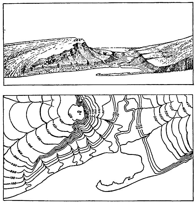
The sketch represents a river valley between two hills. In the foreground is the sea, with a bay which is partly closed by a hooked sand-bar. On each side of the valley is a terrace. From the terrace on the right a hill rises gradually, while from that on the left the ground ascends steeply in a precipice. Contrasted with this precipice is the gentle descent of the slope at the left. In the map each of these features is indicated, directly beneath its position in the sketch, by contours. The following explanation may make clearer the manner in which contours delineate elevation, form, and grade:
[p. 96]
1. A contour indicates approximately a certain height above sea-level. In this illustration the contour interval is 50 feet; therefore the contours are drawn at 50, 100, 150, 200 feet, and so on, above sea-level. Along the contour at 250 feet lie all points of the surface 250 feet above sea; and similarly all elevations above the lower and below the higher contour. Thus the contour at 150 feet falls just below the edge of the terrace, while that at 200 feet lies above the terrace; therefore all points on the terrace are shown to be more than 150 but less than 200 feet above sea. The summit of the higher hill is stated to be 670 feet above sea; accordingly the contour at 650 feet surrounds it. In this illustration nearly all the contours are numbered. Where this is not possible, certain contours — say every fifth one — are accentuated and numbered; the heights of others may then be ascertained by counting up or down from a numbered contour.
2. Contours define the forms of slopes. Since contours are continuous horizontal lines conforming to the surface of the ground, they wind smoothly about smooth surfaces, recede into all re-entrant angles of ravines, and project in passing about prominences. The relations of contour curves and angles to forms of the landscape can be traced in the map and sketch.
3. Contours show the approximate grade of any slope. The vertical space between two contours is the same, whether they lie along a cliff or on a gentle slope ; but to rise a given height on a gentle slope one must go farther along the surface than on a steep slope, and therefore contours are far apart on gentle slopes and near together on steep ones.
For a flat or gently undulating country a small contour interval is used ; for a steep or mountainous country a large interval is necessary. The smallest interval used on the atlas sheets of the Geological Survey is 5 feet. This is used for regions like the Mississippi delta and the Dismal Swamp. In mapping great mountain masses, like those in Colorado, the interval may be 250 feet. For intermediate relief contour intervals of 10, 20, 25, 50, and 100’ feet are used.
Drainage. Watercourses are indicated by blue lines. If the streams flow the year round the line is drawn unbroken, but if the channel is dry a part of the year the line is broken or dotted. Where a stream sinks and reappears at the surface, the supposed underground course is shown by a broken blue line. Lakes, marshes, and other bodies of water are also shown in blue, by appropriate conventional signs.
Culture. The works of man, such as roads, railroads, and towns, together with boundaries of townships, counties, and states, and artificial details, are printed in black." [6]
[p. 97]
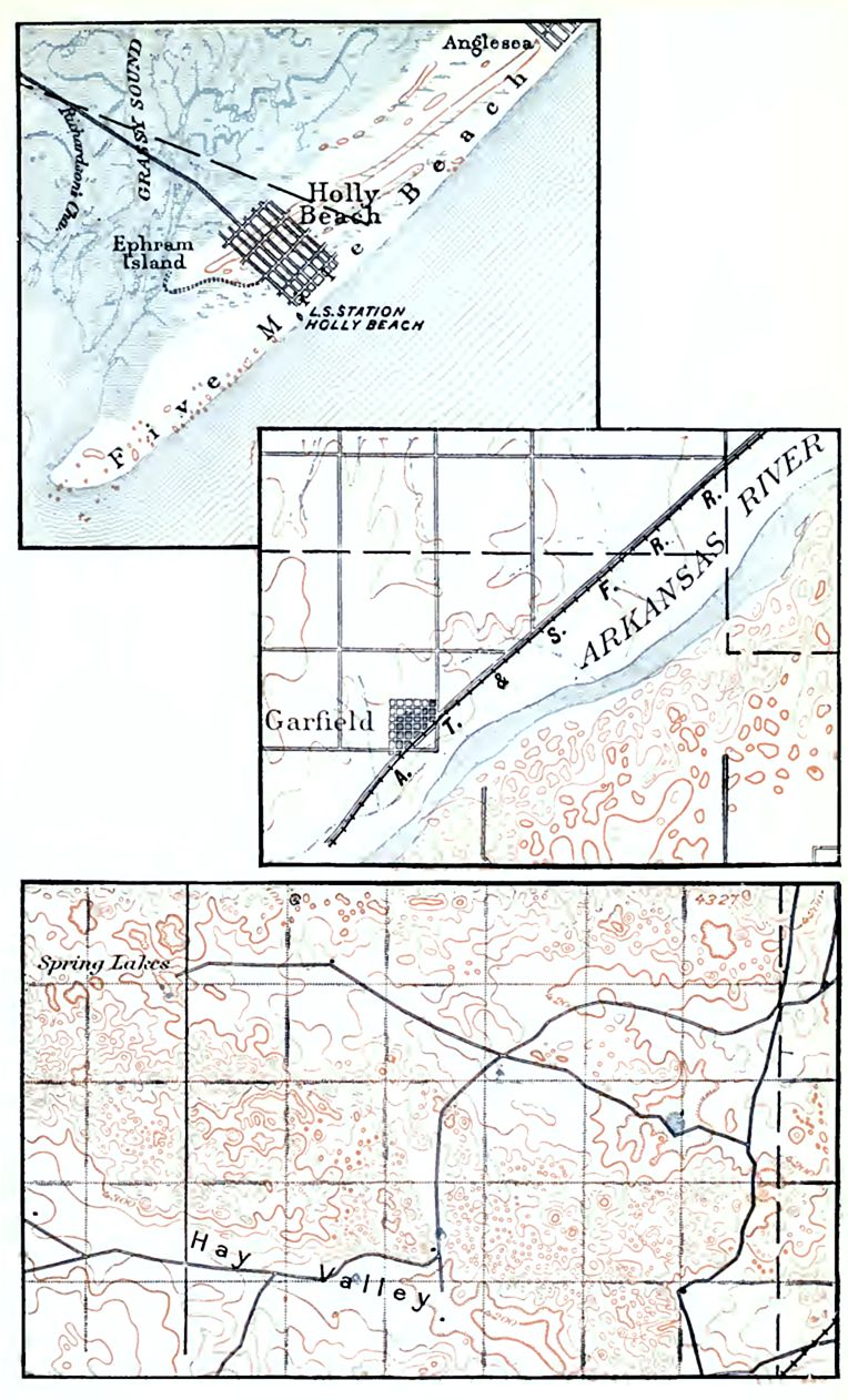
Topography of dune areas. From what has been said, it is clear that the topography of dune regions may vary widely, but it is always distinctive. Where the dunes take the form of ridges (Fig. 1, PL I), the ridges are often of essentially uniform height and width for considerable distances. If there are parallel ridges, they are often separated by trough-like depressions. Where dunes assume the form of hillocks (Figs. 2 and 3, PL I), rather than ridges, the topography is even more distinctive. In some regions depressions (basins) are associated with the dune hillocks. Occasionally they are hardly less notable than the dunes themselves.
Explanation of Plate I. In Fig. 1, Plate I (Five Mile Beach, 8 miles northeast of Cape May, N. J.), the contour interval is 10 feet. There is here but one contour line (the 10-foot contour), though this appears in several places. Since this line connects places 10 feet above sea-level, all places between it and the sea (or marsh) are less than 10 feet above the water, while all places within the lines have an elevation of more than 10 feet. None of them reaches an elevation of 20 feet, since a 20-foot contour does not appear. It will be seen that some of the elevations in Fig. 1 are elongate, while others have the forms of mounds. (From Cape May, N. J., Sheet, U. S. Geol. Surv.)
Fig. 2 shows dune topography along the Arkansas River in Kansas (Larned Sheet), and Fig. 3, dune topography in Nebraska (Camp Clarke Sheet), not in immediate association with a valley or shore. In Fig. 2 the contour interval is 20 feet. All the small hillocks southeast of the river are dunes. Some of them are represented by one contour, and some by two. In Fig. 3, where the contour interval is also 20 feet, there are, besides the numerous hillocks, several depressions (basins). These are represented by hachures inside the contour lines. In some cases there are intermittent lakes (blue) in the depressions. There are two depression contours (4280 and 4260) within the contour of 4300, near Spring Lake. The bottom of the depression is therefore lower than 4260, but not so low as 4240.
Migration of dunes. By the continual transfer of sand from its windward to its leeward side, a dune may be moved from one place to another, though continuing to be made up, in large part, of the same sand. In their migration, dunes sometimes invade fertile lands, causing so great loss that means are devised for stopping them. The simplest method is to help vegetation to get a foothold in the sand. The effect of the vegetation is to pin the sand down. As a dune ridge along a coast travels inland, another may be formed behind it, and successions of dune ridges are thus sometimes formed.
[p. 98]
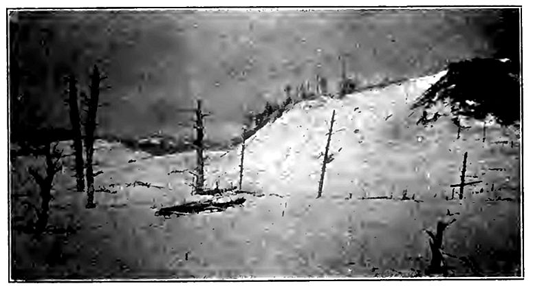
When dunes migrate into a timbered region, they bury and kill the trees (Fig. 59). In one instance on the coast of Prussia a tall pine forest, covering hundreds of acres, was destroyed during the brief period between 1804 and 1827.[7] At some points in New Jersey orchards have been so far buried within the lifetime of their owners that only the tops of the highest trees are exposed.

Trees and other objects once buried may be again discovered by farther migration of the sand (Fig. 60) [2:1]
Distribution of dunes. Dunes are likely to be developed wherever dry sand is exposed to the wind. They are especially characteristic of the dry sandy shores of lakes and seas, of sandy valleys, and of arid sandy plains.
Along coasts, dunes are likely to be extensively developed only where the prevailing winds are on shore. Thus about Lake Michigan, where the prevailing winds are from the west, dunes are abundant and large on the east shore, and but few and small on tho west. Along valleys, dunes are usually on the side toward which [p. 99] the prevailing winds blow. Dunes may be formed in the valley bottoms, but the sand is often blown up out of the valley, and lodged on the bluffs above.
Dunes probably reach their greatest development in the Sahara, where some of them take the form of hillocks, and some the form of ridges. They are also conspicuous in other arid, sandy tracts, as in some parts of western Kansas and Nebraska, and in parts of Wyoming.
Eolian sand is not always built up into dunes. It is sometimes spread somewhat evenly over the surface where it lodges. Eolian sand is probably much more widespread than dunes are.
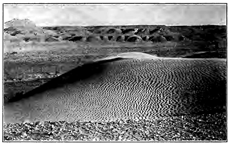
Wind-ripples. The surface of the dry sand over which the wind has blown for a few hours is likely to be marked with ripples (Fig. 61). While the ripples are, as a rule, but a fraction of an inch high, they throw much light on the origin of the great dune ridges. If the ripples be watched closely during the progress of a windstorm, they are found to shift their position gradually. Sand is blown up the gentler windward slope to the crest of the ridge, and falls down on the other side. Wear on the windward side may be about equal to deposition on the leeward, and the result is the [p. 100] orderly progression of the ripples in the direction in which the wind is blowing, just as in the case of dune ridges.
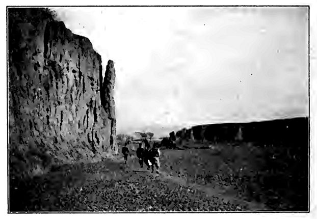
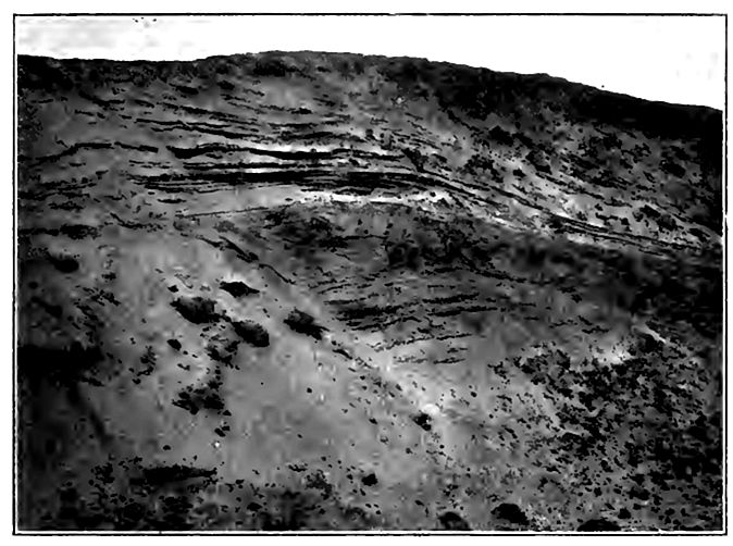
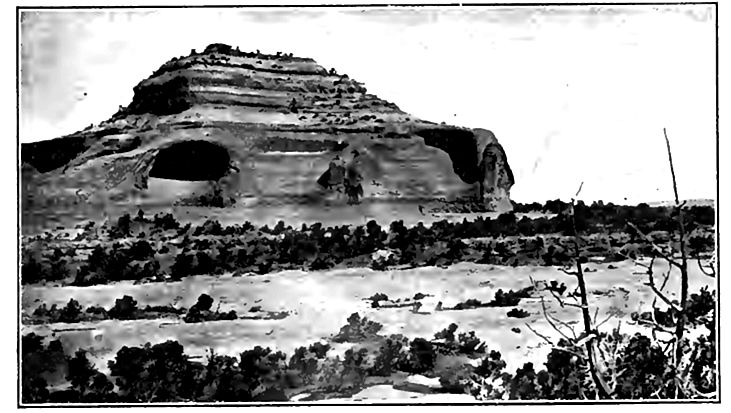
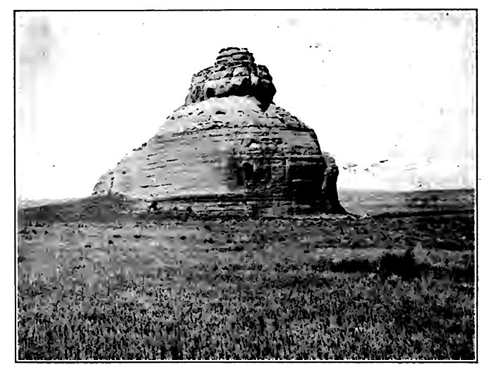
Abrasion by the wind. While the effect of the wind on sandy and dusty surfaces is considerable, its effect on solid rock is relatively slight and accomplished by the impact of the sand and dust it carries. Rock worn in this way acquires a surface peculiar to the agency accomplishing the work. If the rock is made up of laminae which are of unequal hardness, the blown sand digs out the softer ones, leaving the harder ones projecting as ridges between them. Adjacent masses of harder and softer rock of whatever thickness are similarly affected. The sculpturing thus effected on projecting masses of rock is often picturesque and striking (Figs. 62, 63), and is most common in arid regions.
Effect of wind on plants. Another effect of strong winds is seen in the uprooting of trees. The uprooting disturbs the surface in such a way as to make loose earth more readily accessible to wind and water. The uprooting of trees on steep slopes often causes the descent of considerable quantities of loose rock and soil.
[p. 101]
[p. 102]
Again, organisms of various sorts (certain types of seeds, germs, etc.), as well as dust and sand, are extensively transported by the wind.
Indirect effects of the wind. Other dynamic processes are called into being or stimulated by the atmosphere. Winds generate both waves and currents, and both are effective agents in geological work. The results of their activities are discussed elsewhere.
¶ The Chemical Work op the Atmosphere
The chemical work of the atmosphere (including solution and precipitation from solution) is principally accomplished in connection with water, a dry atmosphere having relatively little direct chemical effect on rocks or soils. The important chemical changes wrought by the atmosphere are oxidation, carbonation, and hydration. The nature and the results of these processes have already been noted in connection with the decay of rocks (p. 32). A few other effects of the atmosphere may be noted.
Precipitation from solution. The water in the soil is constantly evaporating. Such substances as it contains in solution are deposited where the water evaporates, and where evaporation is long continued without re-solution of the substances deposited, the surface becomes coated with an efflorescence of mineral matter. An example is found in the alkali plains of certain areas in the western part of the United States. Since the alkaline efflorescence is the result of evaporation, it is connected with the atmosphere, but the material of the efflorescence was brought to its present position by water. Other substances deposited when the water which held them in solution is evaporated, coat the pebbles and stones of arid plains in many places. Gravel is thus cemented into conglomerate not infrequently.
Conditions favorable for chemical changes. Conditions are not everywhere equally favorable for the chemical work of the atmosphere. In general, high temperatures facilitate chemical action, and, other things being equal, rocks are more readily decomposed by the chemical action of the atmosphere in warm than in cold regions. Chemical activity is probably greater where the [p. 103] climate is continuously warm than where there are great changes of temperature. Changes of temperature, on the other hand, tend to disrupt rock, and thus increase the amount of surface exposed to chemical change. Since nearly all the chemical changes worked by the atmosphere on the rocks are increased by the presence of moisture, the chemical activity of the atmosphere is greater in moist than in dry regions.
Though the chemical changes effected by the air are slow, their importance in the course of the earth’s long history must have been very great. The amount of rock which has been thus disintegrated probably far exceeds all that is now above the sea (Chapter VII).
¶ The Atmosphere as a Conditioning Agency
The most obvious mechanical work of the atmosphere is effected by the wind, but mechanical results conditioned by the atmossphere are also effected when the air is still.
Temperature effects. The disrupting effects of changes of temperature have been described briefly (p. 31) and illustrated (Figs. 13 and 14). Several conditions determine the efficiency of this process. The greater and the more sudden the change of temperature, the greater the breaking, the suddenness of the change being more important than its amount. It follows that great daily, rather than great annual, changes of temperature[8] favor rock-breaking. A partial exception to this generalization should be noted. If the pores and cracks are full of moisture, a change of temperature from 45° to 35° (Fahr.) might be far less effective in breaking the rock than a change from 35° to 25° in the same time, for in the latter case the sudden and very considerable expansion (about one-tenth) which water undergoes on freezing is brought into play. This may be called the wedge-work of ice.
The daily range of temperature is influenced especially by (1) latitude, (2) altitude, and (3) humidity. (1) If other things were equal, the greatest daily ranges of temperature would be in low [p. 104] latitudes. (2) High altitudes favor great daily ranges of temperature, so far as the rock surface is concerned, for though the rock becomes heated during the sunny day, the thinness and dryness of the atmosphere allow the heat to radiate rapidly at night. Here, too, the daily range of temperature is likely to bring the wedgework of ice into play. Since the south side of a mountain (in the northern hemisphere) is heated more than the north, it is subject to the greater daily range of temperature, and the rock on this side suffers the greater disruption. Similarly, rock surfaces on which the sun shines daily are subject to greater disruption than those much shielded by clouds. (3) The daily range of temperature is also influenced by humidity, a rock surface becoming hotter by day and cooler by night beneath a dry atmosphere than beneath a moist one. Aridity, therefore, favors the disruption of rock by changing temperatures. The color of rock, its texture, and its composition also influence its range of daily temperature, by influencing absorption and conduction. In general, crystalline rocks are more subject to disruption by this means than sedimentary rocks, partly because they are more compact, and partly because they are made up of aggregates of crystals of different minerals which, under changes of temperature, expand and contract at different rates, while the common sedimentary rocks are made up largely of numerous particles of one mineral.
[p. 105]
The disrupting effects of changes of temperature are slight or nil where the solid rock is protected by soil, clay, sand, gravel, snow, or other incoherent material. If the constituent parts of [p. 106] the loose material are coarse, like bowlders, their surfaces are affected like those of larger bodies of rock.
In view of these considerations, the breaking of rock by changes of temperature should be greatest on the bare slopes of isolated elevations of crystalline rock, and where the atmosphere is relatively free from moisture. All these conditions are not often found in one place, but the disrupting effects of changing temperatures are best seen where several of them are associated.
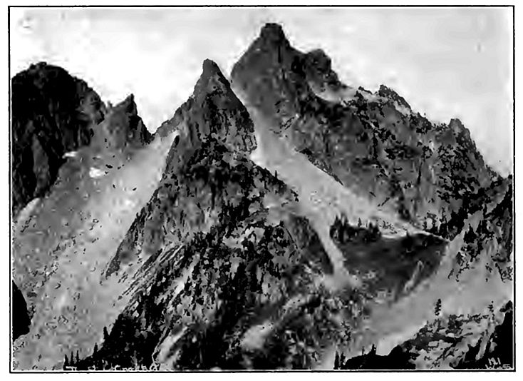
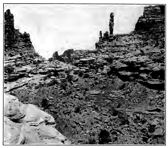
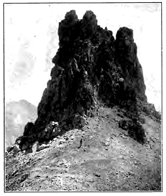
The importance of this method of rock-breaking is rarely appreciated except by those familiar with high and dry regions. Mountain climbers know that most high peaks are covered with broken rock to such an extent as to make their ascent dangerous to the uninitiated. High serrate peaks, especially of crystalline rock, are, as a rule, literally crumbling to pieces (Fig. 65). The piles of talus which lie at the bases of steep mountain slopes (Fig. 66) are often hundreds of feet in height, and their materials are often in large part the result of the process here under discussion. Masses of rock, scores and even hundreds of pounds in weight,[9] are sometimes detached in this way, and started on their downward course, but small pieces of rock are of course much more commonly broken off than large ones.
[p. 107]
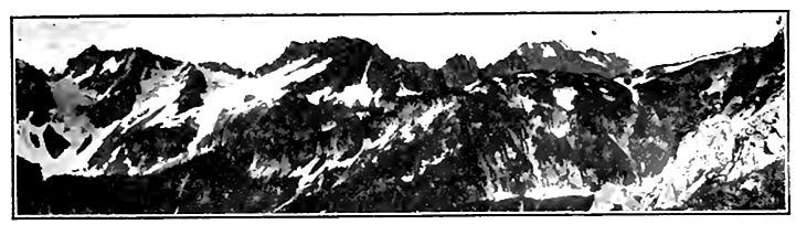
The sharp peaks which mark the summits of most high mountain ranges (Fig. 65) are largely developed by the process here outlined. The altitude at which the serrate topography appears varies with the latitude, being as a rule, higher in low latitudes and lower in high. But even in the same latitude it varies notably with the isolation of the mountains and the humidity of the climate. Thus within the United States the sharply serrate summits (Fig. 67) appear in Washington and Oregon at altitudes of 6,000 to 10,000 feet, while in the isolated Wichita range of Oklahoma, much farther south in a drier climate, the same sort of topography is developed at altitudes of 2,500 to 3,000 feet.
Even in low latitudes and moist climates the effects of temperature changes are often seen. For example, thin beds of limestone at the bottoms of quarries are sometimes so expanded by the heat of the sun as to arch up and break.
The disruption of rock by changes of temperature is one phase of weathering. It tends to the formation of a mantle of rock waste, which, were it not removed, would soon completely cover the solid rock beneath and protect it from further disruption by heating and cooling; but the loose material thus produced be [p. 108] comes an easy prey to running water, so that the work of the atmosphere prepares the way for that of other eroding agencies.
Evaporation and precipitation. Perhaps the most important work of the atmosphere as a geologic agent, lies in its relation to the evaporation, circulation, and distribution of water. Atmospheric temperature is the primary factor governing evaporation, an important factor in the circulation of the vapor after it is formed, and controls its condensation and precipitation.
It is impossible to separate sharply the geologic work of the water of the atmosphere from that of other waters; but so long as moisture is in the atmosphere (including the time of its precipitation) its effects are best considered in connection with the atmosphere.
The mechanical work of the rain. In falling, the rain washes the atmosphere, taking from it much of the dust, spores, etc., which the winds have lifted from the surface of the dry land. Not only this, but in passing through the atmosphere, the water dissolves some of its gases, so that when the rain reaches the land, it is no longer pure, and some of the gases it has taken up in its descent enable it to dissolve various mineral matters on which pure water has little effect.
As it falls on the surface of the land, the rain produces various effects of a mechanical nature. In the first place, it leaves on the surface the solid matter taken from the air. Clayey soils are baked under the influence of the sun, and when in this condition are softened by the rain, and more easily removed by running water. Under the influence of the expansion and contraction caused by wetting and drying, the soils and earths on slopes creep slowly downward. When rain falls on dry sand or dust the cohesion is at once increased, and shifting by the wind is temporarily stopped.
After the water has fallen from the air, its further work cannot be looked upon as a part of the work of the atmosphere; but the proper conception of the geological work of the atmosphere musJ recognize that the waters of the land have come through the atmosphere.
Effects of electricity. Another dynamic effect conditioned by the atmosphere is that produced by lightning. In the aggre [p. 109] gate, this result is inconsequential; yet instances are known where large bodies of rock have been fractured by a stroke of lightning, and masses many tons in weight have sometimes been moved appreciable " distances. Incipient fusion in very limited spots is also known to have been induced by lightning. Thus where it strikes sand it often fuses the sand for a short distance, and, on cooling, the partially fused material is consolidated, forming a little tube or irregular rod (a fulgurite) of partially glassy matter. Fulgurites are usually only a few inches in length, and more commonly than otherwise a fraction of an inch in diameter.
¶ Summary
On the whole, the tendency of the work of the atmosphere and of the work which is controlled by it, is to degrade the land, and to loosen materials of the surface so that they may be readily moved to lower levels by other agencies. The most important phase of the degradational work of the atmosphere is weathering, or the preparation of material for removal by other and more powerful agents of degradation. As we shall see, however, the atmosphere is not the only agent concerned in weathering (see p. 140).
The wind has doubtless been an important agent in the transportation of dust and sand, wherever and whenever there was dry land, ever since an atmosphere has existed. If it has been as effective as now through all the untold millions of years since there have been land and atmosphere, the total amount of work which it must have done is past calculation. Wind-deposited sand, now cemented into solid rock, has been identified, even in very ancient formations.
Laboratory work. The study of topographic and geologic maps, photographs, etc., illustrating wind work may well be taken up in connection with this chapter. Numerous sheets of the topographic maps published by the United States Geological Survey afford illustrations of dunes; so also do a few of the folios. Plates XVI to XXII of Professional Paper 60 of the U. S. Geological Survey afford good illustrations of wind work. A fuller list of topographic maps available for this purpose is to be found on p. 78 of the junior author’s Physiography (Advanced Course).
| Chapter II — THE MATERIALS OF THE EARTH AND THEIR ARRANGEMENT | Index | Chapter IV — LAND WATERS — STREAMS |
For an excellent study of the erosion, transportation, and sedimentation performed by the atmosphere, see Udden, Jour, of Geol., Vol. II, pp. 318-331; also Pop. Sci. Mo., September, 1896. ↩︎
The Eruption of Krakatoa. Committee of the Royal Society, 1888. ↩︎ ↩︎
A brief account of the influence of the dust on sunsets is found in Davis’s Elementary Meteorology, pp. 85 and 119. ↩︎
Von Richtofen; “China.” ↩︎
Chamberlin; Jour, of Geol., Vol. V, p. 79. ↩︎
From folio preface, U. S. Geol. Surv. ↩︎
Merrill. Rocks, Rock Weathering, and Soils, p. 295. ↩︎
It should be noted that it is the change of temperature of the rock surface, not the change of temperature of the air above it, which is to be considered. ↩︎
Livingstone has reported that the temperature of rock surfaces Africa sometimes reaches 137° Fahr. during the day, and cools sufficier at night to split off blocks of 200 lbs. weight. ↩︎